Related Research Articles
The Modified Mercalli intensity scale measures the effects of an earthquake at a given location. This is in contrast with the seismic magnitude usually reported for an earthquake.
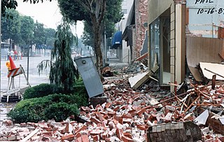
The 1987 Whittier Narrows earthquake occurred in the southern San Gabriel Valley and surrounding communities of Southern California, United States, at 7:42 a.m. PDT on October 1. The moderate magnitude 5.9 blind thrust earthquake was centered several miles north of Whittier in the town of Rosemead, had a relatively shallow depth, and was felt throughout southern California and southern Nevada. Many homes and businesses were affected, along with roadway disruptions, mainly in Los Angeles and Orange counties. Damage estimates ranged from $213–358 million, with 200 injuries, three directly related deaths, and five additional fatalities that were associated with the event.
The Virginia seismic zones in the U.S. state of Virginia include the Giles County seismic zone and the Central Virginia seismic zone. Earthquakes in the state are irregular and rarely reach over 4.5 in magnitude.

The 1909 Wabash River earthquake occurred at 04:45 local time on September 27 with a maximum Mercalli intensity of VII. It measured 5.1 on a seismic scale that is based on an isoseismal map or the event's felt area. With moderate damage in the Wabash River Valley, it is currently the strongest earthquake recorded in the U.S. state of Indiana. The earthquake occurred somewhere along a fault within the Wabash Valley seismic zone.

The 1940 New Hampshire earthquakes struck on December 20 and again on December 24. Both shocks had an estimated Ms magnitude of 5.6, and a maximum Mercalli intensity of VII. These doublet earthquakes were the largest to hit the state in several hundred years. Damage included minor fractures or knocked over chimneys in a zone extending through New Hampshire and four other states: Maine, New York, Vermont and Massachusetts.
The 1867 Manhattan earthquake struck Riley County, Kansas, in the United States on April 24, 1867, at 20:22 UTC, or about 14:30 local time. The strongest earthquake to originate in the state, it measured 5.1 on a seismic scale that is based on an isoseismal map or the event's felt area. The earthquake's epicenter was near the town of Manhattan.
The 1940 El Centro earthquake occurred at 21:35 Pacific Standard Time on May 18 in the Imperial Valley in southeastern Southern California near the international border of the United States and Mexico. It had a moment magnitude of 6.9 and a maximum perceived intensity of X (Extreme) on the Mercalli intensity scale. It was the first major earthquake to be recorded by a strong-motion seismograph located next to a fault rupture. The earthquake was characterized as a typical moderate-sized destructive event with a complex energy release signature. It was the strongest recorded earthquake in the Imperial Valley, causing widespread damage to irrigation systems and killing nine people.
The 1865 Memphis earthquake struck southwest Tennessee near the Mississippi River in the United States on August 17 that year. Soon after the Mfa 5.0 earthquake hit, observers said the earth appeared to undulate and waves formed in nearby rivers. The force of the earthquake felled and cracked chimneys in Memphis and New Madrid, Missouri on the other side of the Mississippi. Shaking from the earthquake spread as far as St. Louis, Missouri; Jackson, Mississippi; and Illinois. Apart from the 1811–12 New Madrid earthquakes, only three major events have struck the state of Tennessee, in 1843, 1865, and 1895. Several minor events have taken place as well.
The 1979 Imperial Valley earthquake occurred at 16:16 Pacific Daylight Time on 15 October just south of the Mexico–United States border. It affected Imperial Valley in Southern California and Mexicali Valley in northern Baja California. The earthquake had a relatively shallow hypocenter and caused property damage in the United States estimated at US$30 million. The irrigation systems in the Imperial Valley were badly affected, but no deaths occurred. It was the largest earthquake to occur in the contiguous United States since the 1971 San Fernando earthquake eight years earlier.
The 1986 North Palm Springs earthquake occurred on July 8 at 02:20:44 local time with a moment magnitude of 6.0 and a maximum Mercalli Intensity of VII. The shock occurred in a complex setting along the San Andreas Fault Zone where it bisects San Gorgonio Mountain and San Jacinto Peak at the San Gorgonio Pass and was the first in a series of three earthquakes that affected southern California and the northern Owens Valley in July 1986. Numerous strong motion instruments recorded the event, one of which showed relatively high accelerations. Between 29 and 40 people were injured, and financial losses were estimated to be in the range of $4.5–6 million.
The 1980 Eureka earthquake occurred on November 8 at 02:27:34 local time along the northern coastal area of California in the United States. With a moment magnitude of 7.3 and a maximum Mercalli intensity of VII, this strike-slip earthquake was the largest to occur in California in 28 years. Although damage was considered light, several loss estimates equaled or exceeded $2 million, and six injuries resulted when two vehicles came down with the partial collapse of a highway overpass on US 101 in Fields Landing. The north coast of California experiences frequent plate boundary earthquakes near the Mendocino triple junction and intraplate events also occur within the Gorda plate.
The 2019 Ridgecrest earthquakes of July 4 and 5 occurred north and northeast of the town of Ridgecrest, California located in Kern County and west of Searles Valley. They included three initial main shocks of Mw magnitudes 6.4, 5.4, and 7.1, and many perceptible aftershocks, mainly within the area of the Naval Air Weapons Station China Lake. Eleven months later, a Mw 5.5 aftershock took place to the east of Ridgecrest. The first main shock occurred on Thursday, July 4 at 10:33 a.m. PDT, approximately 18 km (11.2 mi) ENE of Ridgecrest, and 13 km (8.1 mi) WSW of Trona, on a previously unnoticed NE-SW trending fault where it intersects the NW-SE trending Little Lake Fault Zone. This quake was preceded by several smaller earthquakes, and was followed by more than 1,400 detected aftershocks. The M 5.4 and M 7.1 quakes struck on Friday, July 5 at 4:08 a.m. and 8:19 p.m. PDT approximately 10 km (6 miles) to the northwest. The latter, now considered the mainshock, was the most powerful earthquake to occur in the state in 20 years. Subsequent aftershocks extended approximately 50 km (~30 miles) along the Little Lake Fault Zone.
The 1934 Hansel Valley earthquake occurred on March 12 at approximately 8:05 a.m. MST with a moment magnitude of 6.6 and a maximum Mercalli intensity of VIII (Severe). The shock originated in the Hansel Valley at the north end of the Great Salt Lake in Utah in the United States. Damage was mostly confined to vulnerable buildings, and two people died. The dip-slip (normal) fault that generated the shock ruptured the surface of the ground and other geologic features were documented. A large aftershock occurred three hours after the initial event and may have caused additional damage.
The 1981 Westmorland earthquake occurred at 05:09 Pacific Daylight Time on April 26. The moderate strike-slip shock took place in the Imperial Valley of Southern California, just north of the Mexico–United States border. No injuries or deaths occurred, but damage was estimated at $1–3 million. With a Mercalli intensity of VII, this was one of fifteen intensity VII or greater shocks in the Imperial Valley that were observed in the 20th century up until April 1981. The region experiences large stand-alone events and earthquake swarms due to its position in an area of complex conditions where faulting transitions from strike-slip movement to the north and divergence to the south.
The 1927 Lompoc earthquake occurred on November 4 at 05:49 PST with an epicenter off the coast of Santa Barbara County Southern California. The earthquake measured 7.0 on the moment magnitude scale and had a maximum Modified Mercalli intensity of IX (Violent). It caused widespread damage in several towns of Santa Barbara County. A 2 m tsunami damaged railroad infrastructure and was recorded in Hawaii. There were no injuries or deaths from the earthquake.
The 1968 Borrego Mountain earthquake occurred on April 8, at 18:28 PST in the geologically active Salton Trough of Southern California. The Salton Trough represents a pull-apart basin formed by movements along major faults. This region is dominated by major strike-slip faults one of them being the San Jacinto Fault which produced the 1968 earthquake. The mainshock's epicenter was near the unincorporated community of Ocotillo Wells in San Diego County. The moment magnitude (Mw ) 6.6 strike-slip earthquake struck with a focal depth of 11.1 km (6.9 mi). The zone of surface rupture was assigned a maximum Modified Mercalli intensity (MMI) of VII.
The 1915 Imperial Valley earthquakes were two destructive shocks centered near El Centro, California on June 22. The earthquakes measured Ms 6.25 and occurred nearly one hour apart at 19:59 and 20:57 PST. Both shocks were assigned VIII (Severe) on the Modified Mercalli intensity scale. Heavy damage occurred in the areas of Mexicali and El Centro, amounting to $900,000. At least six people were killed in the earthquakes.
The 1895 Charleston earthquake, also known as the Halloween earthquake, occurred on October 31, at 05:07 CST near Charleston, Missouri. It had an estimated moment magnitude of 5.8–6.6 and evaluated Modified Mercalli intensity of VIII (Severe). The earthquake caused substantial property damage in the states of Missouri, Illinois, Ohio, Alabama, Iowa, Kentucky, Indiana, and Tennessee. Shaking was widespread, being felt across 23 states and even in Canada. At least two people died and seven were injured.
References
- Bakun, W. H.; Hopper, M. G. (2004). Catalog of significant historical earthquakes in the Central United States (PDF) (Report). Open-File Report 2004-1086. doi:10.3133/ofr20041086.
- Stover, Carl W.; Coffman, Jerry L. (1993). "Illinois". Seismicity of the United States, 1568–1989 (revised). U.S. Geological Survey Professional Paper 1527. Washington, D.C.: United States Government Printing Office.