McHenry County was formed in 1836 out of Cook and LaSalle counties. The county was named for Major William McHenry, a member of the Illinois Militia during Tecumseh's War, a major during the Blackhawk War in 1832, and a member of the Illinois House of Representatives and Senate. He died in Vandalia, Illinois in 1835.
McHenry County originally stretched all the way east to Lake Michigan, with the county seat centrally in McHenry, but in 1839, the eastern townships of the county were carved out forming Lake County.
McHenry County at the time of its creation in 1836
McHenry County was reduced to its current size in 1839 by the creation of Lake County, Illinois.
Historical sites
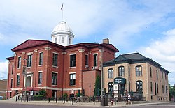
The Terwilliger House is one of several historical sites in McHenry County
According to the U.S. Census Bureau, the county has a total area of 611 square miles (1,580km2), of which 603 square miles (1,560km2) is land and 7.6 square miles (20km2) (1.3%) is water.[5]
In recent years, average temperatures in the county seat of Woodstock have ranged from a low of 11°F (−12°C) in January to a high of 85°F (29°C) in July, although a record low of −29°F (−34°C) was recorded in January 1979 and a record high of 109°F (43°C) was recorded in July 1936. Average monthly precipitation ranged from 1.29 inches (33mm) in February to 4.56 inches (116mm) in June.[6]
McHenry County is like much of the Upper Midwest, as it usually sees hot, humid summers, and cold, snowy winters. The county is notably susceptible to high wind events, blizzards, severe thunderstorms, tornadoes, and flooding.
As of the 2020 census, the county had a population of 310,229, a median age of 40.8 years, and 23.0% of residents under the age of 18 while 15.6% were 65 years of age or older. For every 100 females there were 98.9 males, and for every 100 females age 18 and over there were 97.2 males age 18 and over.[14]
Eighty-five point nine percent of residents lived in urban areas, while 14.1% lived in rural areas.[16]
There were 114,282 households in the county, of which 33.4% had children under the age of 18 living in them, 58.0% were married-couple households, 14.8% were households with a male householder and no spouse or partner present, and 20.6% were households with a female householder and no spouse or partner present.[14]
About 21.7% of all households were made up of individuals and 9.5% had someone living alone who was 65 years of age or older. There were 119,708 housing units, of which 4.5% were vacant, 80.7% of occupied units were owner-occupied, and 19.3% were renter-occupied, with a homeowner vacancy rate of 1.4% and a rental vacancy rate of 5.6%.[14]
Racial and ethnic composition
McHenry County, Illinois – Racial and ethnic composition Note: the US Census treats Hispanic/Latino as an ethnic category. This table excludes Latinos from the racial categories and assigns them to a separate category. Hispanics/Latinos may be of any race.
As of the 2010 census, there were 308,760people, 109,199households, and 82,288families residing in the county.[26] The population density was 511.9 inhabitants per square mile (197.6/km2). There were 116,040 housing units at an average density of 192.4 per square mile (74.3/km2).[5] The racial makeup of the county was 90.1% white, 2.5% Asian, 1.1% black or African American, 0.3% American Indian, 4.3% from other races, and 1.7% from two or more races. Those of Hispanic or Latino origin made up 11.4% of the population.[26] In terms of ancestry, 34.4% were of German heritage, 18.7% were of Irish ancestry, 14.2% Polish, 10.8% Italian, 7.8% English, and 3.7% of American heritage.[27]
Of the 109,199households, 40.1% had children under the age of 18 living with them, 62.3% were married couples living together, 8.9% had a female householder with no husband present, 24.6% were non-families, and 19.8% of all households were made up of individuals. The average household size was 2.81 and the average family size was 3.25. The median age was 38.0 years.[26]
The median income for a household in the county was $76,482 and the median income for a family was $86,698. Males had a median income of $61,971 versus $42,125 for females. The per capita income for the county was $31,838. About 4.9% of families and 6.2% of the population were below the poverty line, including 8.3% of those under age 18 and 4.6% of those age 65 or over.[28]
Racial / Ethnic Profile of places in McHenry County, Illinois (2020 census)
Racial / Ethnic Profile of places in McHenry County, Illinois (2020 Census)
Following is a table of towns and census designated places in NcHenry County, Illinois. Data for the United States (with and without Puerto Rico), the state of Illinois, and McHenry County itself have been included for comparison purposes. The majority racial/ethnic group is coded per the key below. Communities that extend into and adjacent county or counties are delineated with a ‡ followed by an accompanying explanatory note. The full population of each community has been tabulated including the population in adjacent counties.
Majority minority with no dominant group
Majority White
Majority Black
Majority Hispanic
Majority Asian
Racial and ethnic composition of places in McHenry County, Illinois (2020 Census) (NH = Non-Hispanic) Note: the US Census treats Hispanic/Latino as an ethnic category. This table excludes Latinos from the racial categories and assigns them to a separate category. Hispanics/Latinos may be of any race.
McHenry County government is based primarily out of Woodstock, the county seat. The McHenry County Government Center, located on the north end of Woodstock along Illinois Route 47, features county offices as well as judicial facilities.[citation needed]
The current Chairman of the McHenry County Board is Michael Buehler, who was first elected in 2020.[84]
The current Sheriff of McHenry County, Illinois is Robb Tadelmann, who was first elected in 2022.[85]
Politics
As one of the Yankee-settled and prosperous outer suburban "collar counties", McHenry County was a stronghold of the Free Soil Party in its first few elections, being one of nine Illinois counties to give a plurality to Martin van Buren in 1848. McHenry County has voted for the Republican candidate for president in all but two elections since 1852 (the Republican party was founded in 1854), the first being when “Bull Moose” candidate and former Republican president Theodore Roosevelt won the county in 1912.[86] Recent elections in 2004 and 2000 saw George W. Bush capture 59.72% and 58.5% of the county vote, respectively. In 2008, DemocratBarack Obama, then a Senator from Illinois, captured McHenry County with 52% of the vote—the first time a Democrat had carried the county since 1852.[86] In the 2012 presidential election, Obama only received 44% of the vote whereas Republican Mitt Romney captured 53% of the vote.[87] In the 2016 presidential election, Republican Donald Trump received 50% of the vote whereas Democratic Hillary Clinton received 42% of the vote. In 2020, Joe Biden came within 3% of carrying the county for the Democrats for the second time since 1852. McHenry County is now the only collar county that still leans Republican.
No person with significant ties to McHenry County has ever been elected to the United States Congress or Illinois governorship.[citation needed] The mother of U.S. President Gerald Ford, Dorothy Ayer Gardner, was born in Harvard in 1892.
United States presidential election results for McHenry County, Illinois[88]
McHenry County College, a growing community college established in 1967, serves the majority of county residents. The college includes 2,000 full-time students and 5,800 part-time students. The main campus is located on the northwest side of Crystal Lake, along U.S. Route 14. Secondary facilities exist in Crystal Lake and McHenry.
McHenry County also includes dozens of school districts. This is a list of high schools that can be found in the county:
Hospitals currently in the county include Mercy Harvard Hospital, Centegra Northern Illinois Medical Center in McHenry, Centegra Memorial Medical Center in Woodstock, and Centegra's Northwestern Medicine Huntley Hospital. Amita (formerly Presence) and Advocate health systems also maintain a strong influence in the county, and have hospitals in nearby Elgin and Barrington. On September 1, 2018, Centegra was acquired by Northwestern Medicine of Chicagonois. Prior to its acquisition by Northwestern Medicine, Centegra was the largest independent employer in McHenry County. It is now part of a network of more than 10 hospitals and 400 care locations.
Economy
Much of McHenry County's economy centers around manufacturing, metalworking, media development and printing, transportation equipment, agriculture, health care, education, retail, food production, distribution, and technology. Gravel mining makes up a sizable portion of the county's economy.[95]
The major employment centers can be found in Crystal Lake, Algonquin, Huntley, McHenry, and Woodstock.[96][citation needed] The southern portions of the county are within the scope of the Golden Corridor, the region of commerce along the Jane Addams Memorial Tollway.
Shopping
The county is known for its wide variety of shopping options. McHenry, Crystal Lake, and Algonquin/Lake in the Hills have established themselves as major retail areas, all featuring an array of big box stores, specialty stores, and restaurants. While there are no major malls located within the county, several lie just outside its borders: the lifestyle centersAlgonquin Commons and Algonquin Galleria, and the regional indoor mall Spring Hill Mall in West Dundee.
In addition, several historic downtowns throughout the county offer unique shops and eateries in charming environments. The Woodstock Square Historic District, antique shops in Richmond and Hebron, downtown Crystal Lake and downtown Algonquin, and shops in other historic downtowns throughout the county accommodate residents and tourists alike. McHenry's Green Street is also a major attraction in the county.
Recreation
Glacial Park, located in Northeast McHenry County
The entire county is served by the McHenry County Conservation District, which preserves sensitive land throughout the county and provides recreational opportunities for residents. The District also operates the McHenry County Prairie Path, a regional bike path that extends from the Wisconsin State Line in Richmond southward to Algonquin, where the path connects with the Fox River Bike Trail, which continues south to Aurora.
In addition, the Fox River, Kishwaukee River and Chain O'Lakes provide immense opportunities for boating, fishing, swimming, and other water activities. Moraine Hills State Park and Chain O' Lakes State Park are both located in the county, adjacent to the waterway. Other major lakes in the county include Crystal Lake, Wonder Lake, and McCullom Lake.
There are also dozens of parks, golf courses, and country clubs throughout the county. Major skiing areas include Nordic Ski Jump in Fox River Grove and Buffalo Snowboarding Park in Algonquin. In addition, the Windy City Balloon Port in Fox River Grove offers hot air balloon rides over the Fox River Valley.
McHenry County has an active art and theater scene. The historic Woodstock Opera House and Crystal Lake's Raue Center for the Arts both provide exceptional programs. In addition, Algonquin is noted for its Public Art Program, which showcases artwork year-round throughout the community. The county is also ideal for photography and filming. Much of the filming for the 1993 movie Groundhog Day took place in Woodstock.
Throughout the year are a variety of festivals throughout the county, the centerpiece of which is the McHenry County Fair, occurring during a week in August in Woodstock. Many towns also have their own festivals throughout the year. Some of the most notable ones are the Ground Hog Days and the Great Lake Steelpan Festival in Woodstock, Fall Fest in Huntley, the Summer Sunset Festival in Lake in the Hills, the Lakeside Festival in Crystal Lake, Milk Days in Harvard, Settler's Days in Marengo, Cary Days in Cary, Founders Days in Algonquin, and Fiesta Days in McHenry.
McHenry County was the most populous county in the United States without direct access to an Interstate Highway within its borders. As a result, residents usually used the nearby Interstate 90 (the Jane Addams Memorial Tollway), via interchanges in neighboring Kane County. But a new interchange is now completed at I-90 and Illinois Route 23, which provides McHenry County with direct access to the interstate highway system.
Interstate 94 lies to the east of McHenry County in Lake County, Illinois.
Mass transportation
McHenry County is served by Metra Rail, which provides daily commuter service to and from downtown Chicago. There are seven stations in the county, all of them located along the Union Pacific Northwest Line. The county is also served by Pace, which provides four fixed bus routes (550, 806, 807, and 808), and MCRide Dial-A-Ride transit service operated by Pace and First Transit. Those who receive an RTA Reduced Fare, Ride Free or ADA Paratransit Permit can also apply for MCRide Connect, a local version of the Rideshare Access Program (RAP) that provides vouchers for rides on either Uber or UZURV as long as either the pick-up, destination or both are in the county.
McHenry County is entirely within the scope of the Chicagomedia market and the majority of the county relies primarily on Chicago television stations, radio stations, and newspapers for the source of its news and information. Certain sections of the county, particularly the rural far northern and far western parts, are also within the scope of the Milwaukee and Rockford media markets, respectively.
The county has an FM radio station, WZSR (Star 105.5 FM), which plays mostly adult contemporary and pop music. WZSR is based out of Crystal Lake.
The Northwest Herald, with a circulation of approximately 21,000,[97] is the county's primary newspaper, serving the greater McHenry County area, and printed and published in Crystal Lake.
Lake and McHenry County Scanner, launched in 2012 by Sam Borcia, is a local digital newspaper which covers McHenry County and nearby Lake County, Illinois.[98]
↑"About Us". Lake and McHenry County Scanner. Retrieved September 10, 2021.
General
Forstall, Richard L. (editor) (1996). Population of states and counties of the United States: 1790 to 1990: from the twenty-one decennial censuses. United States Department of Commerce, Bureau of the Census, Population Division. ISBN0-934213-48-8.{{cite book}}: |first= has generic name (help)
Further reading
Dupré, D.H. and D.M. Robertson. (2004). Water quality of Nippersink Creek and Wonder Lake, McHenry County, Illinois, 1994-2001 [Scientific Investigations Report 2004-5085]. Reston, VA: U.S. Department of the Interior, U.S. Geological Survey.
This page is based on this Wikipedia article Text is available under the CC BY-SA 4.0 license; additional terms may apply. Images, videos and audio are available under their respective licenses.