Marengo, Illinois

Last updated

Marengo
Marengo Illinois1.jpg
Buildings in downtown Marengo.
Motto: 
Home of Settlers Days
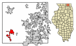
McHenry County Illinois Incorporated and Unincorporated areas Marengo Highlighted.svg
Location of Marengo in McHenry County, Illinois.
Illinois in United States (US48).svg
Location of Illinois in the United States
Coordinates: city_region:US-IL 42°15′03″N88°36′18″W / 42.25083°N 88.60500°W / 42.25083; -88.60500
CountryUnited States
StateIllinois
County McHenry
Township Marengo, Seneca, Coral, Riley
Founded1835
Government
   Mayor John Koziol
Area
[1]
  Total8.90 sq mi (23.06 km2)
  Land8.90 sq mi (23.06 km2)
  Water0.00 sq mi (0.00 km2)
Elevation
[2]
833 ft (254 m)
Population
 (2020)
  Total7,568
  Density850.15/sq mi (328.25/km2)
Time zone UTC-6 (CST)
  Summer (DST) UTC-5 (CDT)
ZIP Code
60152
Area code(s) 815/779
FIPS code 17-46786
Wikimedia CommonsMarengo, Illinois
Website www.cityofmarengo.com

Marengo is a city in McHenry County, Illinois, United States on the Kishwaukee River. It lies approximately 60 miles west northwest of Chicago and approximately 30 miles east of Rockford. Per the 2020 census, the population was 7,568. [3]

Contents

Geography

Marengo is located at 42°15′3″N88°36′18″W / 42.25083°N 88.60500°W / 42.25083; -88.60500 . [4]

The north edge of Marengo is bordered by the Kishwaukee River

According to the 2010 census, Marengo has a total area of 5.01 square miles (12.98 km2), all land. [5]

Major streets

Climate

Climate data for Marengo, Illinois (1991–2020 normals, extremes 1893–2018)
MonthJanFebMarAprMayJunJulAugSepOctNovDecYear
Record high °F (°C)62
(17)
73
(23)
84
(29)
94
(34)
107
(42)
107
(42)
109
(43)
107
(42)
103
(39)
90
(32)
80
(27)
67
(19)
109
(43)
Mean maximum °F (°C)47.6
(8.7)
52.6
(11.4)
68.9
(20.5)
81.5
(27.5)
87.2
(30.7)
94.0
(34.4)
95.3
(35.2)
93.4
(34.1)
89.3
(31.8)
81.9
(27.7)
67.1
(19.5)
50.4
(10.2)
97.1
(36.2)
Mean daily maximum °F (°C)29.2
(−1.6)
33.2
(0.7)
44.9
(7.2)
58.6
(14.8)
70.2
(21.2)
79.9
(26.6)
83.5
(28.6)
81.8
(27.7)
75.4
(24.1)
62.4
(16.9)
46.9
(8.3)
34.5
(1.4)
58.4
(14.7)
Daily mean °F (°C)20.9
(−6.2)
24.5
(−4.2)
35.4
(1.9)
47.4
(8.6)
58.7
(14.8)
68.6
(20.3)
72.6
(22.6)
70.7
(21.5)
63.6
(17.6)
51.2
(10.7)
38.0
(3.3)
26.5
(−3.1)
48.2
(9.0)
Mean daily minimum °F (°C)12.7
(−10.7)
15.8
(−9.0)
25.9
(−3.4)
36.2
(2.3)
47.2
(8.4)
57.2
(14.0)
61.7
(16.5)
59.6
(15.3)
51.8
(11.0)
39.9
(4.4)
29.1
(−1.6)
18.5
(−7.5)
38.0
(3.3)
Mean minimum °F (°C)−11.3
(−24.1)
−6.1
(−21.2)
7.5
(−13.6)
20.6
(−6.3)
32.1
(0.1)
42.9
(6.1)
49.4
(9.7)
47.7
(8.7)
35.4
(1.9)
24.6
(−4.1)
12.6
(−10.8)
−3.8
(−19.9)
−14.7
(−25.9)
Record low °F (°C)−29
(−34)
−27
(−33)
−16
(−27)
6
(−14)
21
(−6)
29
(−2)
39
(4)
37
(3)
24
(−4)
8
(−13)
−17
(−27)
−26
(−32)
−29
(−34)
Average precipitation inches (mm)1.67
(42)
1.64
(42)
2.08
(53)
3.81
(97)
4.57
(116)
4.62
(117)
4.05
(103)
4.22
(107)
3.68
(93)
2.98
(76)
2.35
(60)
1.94
(49)
37.61
(955)
Average snowfall inches (cm)8.0
(20)
9.1
(23)
2.4
(6.1)
0.4
(1.0)
0.0
(0.0)
0.0
(0.0)
0.0
(0.0)
0.0
(0.0)
0.0
(0.0)
0.0
(0.0)
1.6
(4.1)
9.3
(24)
30.8
(78)
Average precipitation days (≥ 0.01 in)7.25.87.910.511.79.89.09.07.28.07.47.4100.9
Average snowy days (≥ 4.4)3.51.10.40.00.00.00.00.00.00.00.63.313.3
Source: NOAA (mean maxima/minima 19812010) [6] [7]

History

Marengo was first named Pleasant Grove after a grove of trees near the town site. [8] The present name commemorates the Battle of Marengo. [8] A post office named Marengo was established in 1844. [9]

In the early morning of June 11, 2017, at around 4:50 A.M., a house in the northwest suburbs exploded. The gas explosion set four houses on fire and damaged 50 more, nearly 20 of which were deemed "unlivable." Despite the extensive damage, no fatalities or serious injuries occurred; only two people were reported to have suffered minor injuries. [10] [11]

Government

Marengo is governed by the mayor, John Koziol, and a city council of eight aldermen.

Demographics

Historical population
CensusPop.Note
1860 1,119
1870 1,32718.6%
1880 1,264−4.7%
1890 1,44514.3%
1900 2,00538.8%
1910 1,936−3.4%
1920 1,758−9.2%
1930 1,94810.8%
1940 2,0344.4%
1950 2,72634.0%
1960 3,56830.9%
1970 4,23518.7%
1980 4,3613.0%
1990 4,7689.3%
2000 6,35533.3%
2010 7,64820.3%
2020 7,568−1.0%
U.S. Decennial Census [12]
2010 [13] 2020 [14]

2020 census

Marengo city, Illinois - Demographic Profile
(NH = Non-Hispanic)
Note: the US Census treats Hispanic/Latino as an ethnic category. This table excludes Latinos from the racial categories and assigns them to a separate category. Hispanics/Latinos may be of any race.
Race / EthnicityPop 2010 [13] Pop 2020 [14] % 2010% 2020
White alone (NH)6,3055,75882.44%76.08%
Black or African American alone (NH)41940.54%1.24%
Native American or Alaska Native alone (NH)16200.21%0.26%
Asian alone (NH)37510.48%0.67%
Pacific Islander alone (NH)100.01%0.00%
Some Other Race alone (NH)7160.09%0.21%
Mixed Race/Multi-Racial (NH)692480.90%3.28%
Hispanic or Latino (any race)1,1721,38115.32%18.25%
Total7,6487,568100.00%100.00%

2000 Census

As of the census [15] of 2000, there were 6,355 people, 2,387 households, and 1,694 families residing in the city. The population density was 1,598.5 inhabitants per square mile (617.2/km2). There were 2,475 housing units at an average density of 622.6 per square mile (240.4/km2). The racial makeup of the city was 92.07% White, 0.30% African American, 0.27% Native American, 0.28% Asian, 0.02% Pacific Islander, 5.54% of other races, and 1.53% of two or more races. Hispanic or Latino of any race were 13.00% of the population.

There were 2,387 households, out of which 38.6% had children under the age of 18 living with them, 55.9% were married couples living together, 10.7% had a female householder with no husband present, and 29.0% were non-families. 24.9% of all households were made up of individuals, and 9.8% had someone living alone who was 65 years of age or older. The average household size was 2.64 and the average family size was 3.17.

The population was spread out, with 29.3% under the age of 18, 8.6% from 18 to 24, 31.0% from 25 to 44, 19.2% from 45 to 64, and 12.0% who were 65 years of age or older. The median age was 34 years. For every 100 females, there were 96.3 males. For every 100 females age 18 and over, there were 94.3 males.

The median income for a household in the city was $50,214, and the median income for a family was $57,209. Males had a median income of $41,298 versus $26,317 for females. The per capita income for the city was $22,225. About 3.9% of families and 4.4% of the population were below the poverty line, including 5.4% of those under age 18 and 5.5% of those age 65 or over.

Notable people

Media

The Marengo-Union Times is the newspaper of record in Marengo, IL. It has a circulation of 6,300 and is mailed to every home and business in the greater Marengo and Union, Illinois area.

Related Research Articles

<span class="mw-page-title-main">Berkeley, Illinois</span> Village in Illinois, United States

Berkeley is a village located in Cook County, Illinois, United States. Incorporated in 1924, the population at the 2020 census was 5,338.

<span class="mw-page-title-main">Burnham, Illinois</span> Village in Illinois, United States

Burnham is a village in Cook County, Illinois, United States. The population was 4,046 at the 2020 census. The ZIP code is 60633.

<span class="mw-page-title-main">Flossmoor, Illinois</span> Village in Illinois, United States

Flossmoor is a village in Cook County, Illinois, United States. The population was 9,704 at the 2020 census. Flossmoor is approximately 24 miles south of The Loop/Downtown Chicago. It is closely tied to neighboring Homewood, sharing a high school and park district.

<span class="mw-page-title-main">Hometown, Illinois</span> City in Cook County, Illinois, US

Hometown is a city in Cook County, Illinois, United States. The population was 4,343 at the 2020 census.

<span class="mw-page-title-main">Lansing, Illinois</span> Village in Illinois, United States

Lansing is a village in Cook County, Illinois, United States. Lansing is a south suburb of Chicago. The population was 29,076 at the 2020 census.

<span class="mw-page-title-main">Merrionette Park, Illinois</span> Village in Illinois, United States

Merrionette Park is a village in Cook County, Illinois, United States. The population was 1,969 as of the 2020 census.

<span class="mw-page-title-main">South Barrington, Illinois</span> Village in Illinois, United States

South Barrington is a residential suburb in Cook County, Illinois, United States, south of Barrington. Per the 2020 census, the population was 5,077. South Barrington is a wealthy suburb of Chicago. It is the location of the famous megachurch Willow Creek Community Church, Goebbert's Pumpkin Patch and Farm, and a lifestyle center named The Arboretum of South Barrington.

<span class="mw-page-title-main">South Holland, Illinois</span> Village in Illinois, United States

South Holland is a village and south suburb of Chicago in Cook County, Illinois, United States, within Thornton Township. The population was 21,465 at the 2020 census.

<span class="mw-page-title-main">Thornton, Illinois</span> Village in Illinois, United States

Thornton is a village in Cook County, Illinois, United States and a south suburb of Chicago. The population was 2,386 at the 2020 census. Thornton is home to the Thornton Quarry, one of the largest quarries in the world.

<span class="mw-page-title-main">Malta, Illinois</span> Village in Illinois, United States

Malta is a village in DeKalb County, Illinois, United States. The population was 1,143 at the 2020 census.

<span class="mw-page-title-main">Gilberts, Illinois</span> Village in Illinois, United States

Gilberts is a village in Kane County, Illinois, United States. The population was 8,366 at the 2020 census.

<span class="mw-page-title-main">Huntley, Illinois</span> Village in Illinois, United States

Huntley is a village in McHenry and Kane counties, Illinois, United States. As of the 2021 census it had a population of 28,008. It is a part of the Chicago metropolitan area.

<span class="mw-page-title-main">Pingree Grove, Illinois</span> Village in Illinois, United States

Pingree Grove is a village in Kane County, Illinois, United States. The population was 124 at the 2000 census. However, with rapid development in the following years, the 2010 census indicated 4,532 residents, and the 2020 census was 10,365.

<span class="mw-page-title-main">Boulder Hill, Illinois</span> Census-Designated Place in Illinois, United States

Boulder Hill is a census-designated place (CDP) in Oswego Township, Kendall County, Illinois, United States. Per the 2020 census, the population was 8,394. It is part of the Chicago metropolitan area on the Fox River, south of Aurora.

Fox Lake Hills is an unincorporated community and census-designated place (CDP) in Lake Villa Township, Lake County, Illinois, United States. Per the 2020 census, the population was 2,684.

<span class="mw-page-title-main">North Chicago, Illinois</span> City in Illinois, United States

North Chicago is a city in Lake County, Illinois, United States, and a suburb of the Chicago metropolitan area. The population was 30,759 at the 2020 census making it the 3rd largest city by population in the county, after Waukegan and Mundelein.

<span class="mw-page-title-main">Lakewood, Illinois</span> Village in Illinois, United States

The Village of Lakewood is a village in McHenry County, Illinois, United States. It was incorporated as a village on July 10, 1933. Per the 2020 census, the population was 4,283. Although commonly referred to as Lakewood, the town's proper name is preceded by 'The Village of'.

<span class="mw-page-title-main">Union, Illinois</span> Village in Illinois, United States

Union is a village in McHenry County, Illinois, United States. The population was 551 at the 2020 census.

<span class="mw-page-title-main">Preston Heights, Illinois</span> Census-designated place in Illinois, United States

Preston Heights is a census-designated place (CDP) in Will County, Illinois, United States. As of the 2020 census, the CDP population was 2,898.

<span class="mw-page-title-main">Sun City Center, Florida</span> Census-designated place in Florida, United States

Sun City Center is an unincorporated census-designated place (CDP) in southern Hillsborough County, Florida, United States. It is located south of Tampa and north of Sarasota on I-75. As of the 2020 census, the population was 30,952. The ZIP Code serving the community is 33573.

References

  1. "2020 U.S. Gazetteer Files". United States Census Bureau. Retrieved March 15, 2022.
  2. "USGS detail on Newtown" . Retrieved October 21, 2007.
  3. "Marengo city, Illinois". United States Census Bureau . Retrieved April 15, 2022.
  4. "US Gazetteer files: 2010, 2000, and 1990". United States Census Bureau. February 12, 2011. Retrieved April 23, 2011.
  5. "G001 - Geographic Identifiers - 2010 Census Summary File 1". United States Census Bureau. Archived from the original on February 13, 2020. Retrieved December 27, 2015.
  6. "NOWData – NOAA Online Weather Data". National Oceanic and Atmospheric Administration. Retrieved May 20, 2023.
  7. "Summary of Monthly Normals 1991–2020". National Oceanic and Atmospheric Administration. Retrieved May 20, 2023.
  8. 1 2 Chicago and North Western Railway Company (1908). A History of the Origin of the Place Names Connected with the Chicago & North Western and Chicago, St. Paul, Minneapolis & Omaha Railways. p. 98.
  9. "McHenry County". Jim Forte Postal History. Retrieved March 22, 2015.
  10. Marrazzo, Amanda. "'A miracle' that no one killed during Marengo explosion that set 4 houses ablaze". chicagotribune.com. Retrieved December 30, 2018.
  11. Rohr, Lauren (June 11, 2018). "One year after Marengo neighborhood explosion, families still seeking normalcy". Daily Herald. Retrieved December 30, 2018.
  12. "Decennial Census of Population and Housing by Decades". US Census Bureau.
  13. 1 2 "P2 HISPANIC OR LATINO, AND NOT HISPANIC OR LATINO BY RACE – 2010: DEC Redistricting Data (PL 94-171) – Marengo city, Illinois". United States Census Bureau .
  14. 1 2 "P2 HISPANIC OR LATINO, AND NOT HISPANIC OR LATINO BY RACE – 2020: DEC Redistricting Data (PL 94-171) – Marengo city, Illinois". United States Census Bureau .
  15. "U.S. Census website". United States Census Bureau . Retrieved January 31, 2008.