McHenry County is a county located in the U.S. state of Illinois. According to the 2020 Census, it had a population of 310,229, making it the sixth-most populous county in Illinois. Its county seat is Woodstock. McHenry County is one of the five collar counties of the Chicago-Naperville-Elgin, IL-IN-WI Metropolitan Statistical Area. Long known as a center of recreation along with agriculture in the western portion, it has more recently experienced rapid rates of suburbanization, exurbanization and urbanization, but the western portions of the county remain primarily agricultural and rural.

Lake County is situated in the northeastern corner of the U.S. state of Illinois, along the shores of Lake Michigan. As of the 2020 census, it has a population of 714,342, making it the third-most populous county in Illinois. Its county seat is Waukegan, the tenth-largest city in Illinois. The county is primarily suburban, with some urban areas and some rural areas. Due to its location, immediately north of Cook County, Lake County is one of the collar counties of the Chicago metropolitan area. Its northern boundary is the Wisconsin state line.

Scouting in Illinois has served youth since 1909. The state was the home of the Boy Scouts of America (BSA) founder, William D. Boyce.

Buffalo Grove is a village in Lake and Cook Counties in the U.S. state of Illinois. A suburb of Chicago, it lies about 30 miles (50 km) northwest of Downtown Chicago. As of the 2020 Census, Buffalo Grove has a population of 43,212. It totals 9.6 square miles (25 km2) of land, with the top three-quarters in Lake County and the bottom quarter in Cook County. Roads in the village such as Lake Cook Road and Illinois Route 83 converge on I-294, which take drivers to O'Hare International Airport 20 miles (32 km) south of Buffalo Grove. A part of the Chicago Metropolitan Area, Buffalo Grove is consistently ranked as one of the best places to live in Illinois and the Midwest, as well as one with the highest school district rankings in the country.

Naperville is a city in DuPage and Will counties in the U.S. state of Illinois. It is a southwestern suburb of Chicago located 28 miles (45 km) west of the city on the DuPage River. As of the 2020 census, its population was 149,540, making it the state's fourth-most populous city.

Algonquin is a village in McHenry and Kane counties, Illinois, in the United States. It is a suburb of Chicago, located approximately 40 miles (64 km) northwest of the Loop. As of the 2020 census, the village's population was 29,700.

Mettawa is a village in Lake County, Illinois, United States. Per the 2020 census, the population was 533. The village maintains trails for pedestrian, bicycle and equestrian usage. Five forest preserves of the Lake County Forest Preserve District are located within village boundaries.

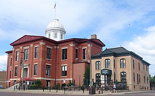
Johnsburg is a village in McHenry County, Illinois. It is a northwestern suburb of Chicago with a population of 6,355 as of the 2020 U.S. census.

McHenry is a city in McHenry County, Illinois, United States. It is a suburb, part of the Chicago metropolitan area and is located about 50 miles northwest of Chicago. Per the 2020 census, the population was 27,135. McHenry was at one time the county seat of McHenry County, which once included adjoining Lake County to the east. McHenry took its name from the county, which was named for Major William McHenry, a prominent US Army officer in the Black Hawk War.
A kame delta is a glacial landform formed by a stream of melt water flowing through or around a glacier and depositing material, known as kame deposits. Upon entering a proglacial lake at the end (terminus) of a glacier, the river/stream deposit these sediments. This landform can be observed after the glacier has melted and the delta's asymmetrical triangular shape is visible. Once the glacier melts, the edges of the delta may subside as ice under it melts. Glacial till is deposited on the lateral sides of the delta, as the glacier melts.

The Kishwaukee River, locally known as simply The Kish, is a 63.4-mile-long (102.0 km) river in the U.S. state of Illinois. It is a tributary of the Rock River and its name derives from the Potawatomi word for "river of the sycamore".
The Nantahala National Forest is the largest of the four national forests in North Carolina, lying in the mountains and valleys of western North Carolina. The Nantahala is the second wettest region in the country, after the Pacific Northwest. Due to its environmental importance and historical ties with the Cherokee, the forest was officially established on January 29, 1920, by President Woodrow Wilson. The word "Nantahala" is a Cherokee derived, meaning "Land of the Noonday Sun." In some spots, the sun reaches the floors of the deep gorges of the forest only when it is high overhead at midday. This was part of the homeland of the historic Cherokee and their indigenous ancestors, who have occupied the region for thousands of years.

Danville is a city in and the county seat of Vermilion County, Illinois, United States. As of the 2020 census, its population was 29,204. It is the principal city of the Danville metropolitan area.
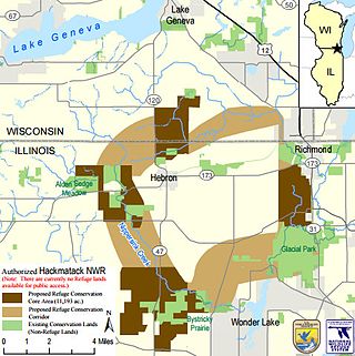
The Hackmatack National Wildlife Refuge is a newly established United States national wildlife refuge that will include noncontiguous properties, especially tallgrass prairie patches, wetland properties, and oak savanna parcels, located in the northwestern region of the Chicago metropolitan area and the southern part of the Milwaukee area. The refuge's boundaries encompass parts of McHenry County, Illinois, and Walworth County, Wisconsin. The refuge will be operated by the United States Fish and Wildlife Service, known as USFWS. 85 percent of the refuge will be in Illinois, and 15 percent in Wisconsin.

The Big Sur Land Trust is a private 501(c)(3) non-profit located in Monterey, California, that has played an instrumental role in preserving land in California's Big Sur and Central Coast regions. The trust was the first to conceive of and use the "conservation buyer" method in 1989 by partnering with government and developers to offer tax benefits as an inducement to sell land at below-market rates. Since 1978, with the support of donors, funders and partners, it has conserved over 40,000 acres through conservation easements, acquisition and transfer of land to state, county and city agencies. It has placed conservation easements on 7,000 acres and has retained ownership of over 4,000 acres.
Fort Daniel Conservation Area is a 200-acre (0.8 km²) park located 4 miles (6.5 km) east of Mount Zion, Illinois. The land preserve protects the site of a ghost town, Whistleville. Today, the site centers on hiking and picknicking in the Big Creek watershed southeast of Decatur.
The Prairie Trail is a 26-mile-long (42 km) shared use path for walking and cycling, located adjacent in McHenry County, Illinois. The path is part of the Grand Illinois Trail and connects McHenry County to other trails in the Chicago metropolitan area. It is considered to be a good example of convert old methods of transportation to a new one.

The 2022 United States Senate election in Illinois was held on November 8, 2022, to elect a member of the United States Senate to represent the state of Illinois.
The Macon County Conservation District (MCCD) is a public park authority, created in 1966, serving the metropolitan area of Decatur in the U.S. state of Illinois. The conservation district operates five conservation areas and six historic sites, as of 2022, throughout Macon County. Facilities include the park district's flagship open space, Rock Springs Conservation Area; a nature center within the Conservation Area, the Rock Springs Nature Center; and an Illinois State Natural Area, the Bois du Sangamon by Lake Decatur.