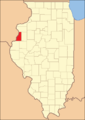
Henderson County, Illinois

Last updated

Henderson County
Henderson County Courthouse, Oquawka.jpg
Map of Illinois highlighting Henderson County.svg
Location within the U.S. state of Illinois
Illinois in United States.svg
Illinois's location within the U.S.
Coordinates: 40°49′N90°56′W / 40.81°N 90.93°W / 40.81; -90.93
CountryFlag of the United States.svg United States
StateFlag of Illinois.svg  Illinois
Founded1841
Named for Richard Henderson
Seat Oquawka
Largest villageOquawka
Area
  Total395 sq mi (1,020 km2)
  Land379 sq mi (980 km2)
  Water16 sq mi (40 km2)  4.1%
Population
 (2020)
  Total6,387
  Density16/sq mi (6.2/km2)
Time zone UTC−6 (Central)
  Summer (DST) UTC−5 (CDT)
Congressional district 15th
Website www.hendersoncountyedc.com

Henderson County is a county located in the U.S. state of Illinois. According to the 2020 United States Census, it has a population of 6,387. [1] Its county seat is Oquawka. [2]

Contents

Henderson County is part of the Burlington, IA–IL Micropolitan Statistical Area.

History

Henderson County was formed in 1841 from a portion of Warren County. It was named for Henderson County, Kentucky, which was named for Richard Henderson, [3] founder of the Transylvania Company, an early attempt to organize what later became Kentucky around 1775.

Geography

According to the US Census Bureau, the county has a total area of 395 square miles (1,020 km2), of which 379 square miles (980 km2) is land and 16 square miles (41 km2) (4.1%) is water. [4]

Climate and weather

Oquawka, Illinois
Climate chart (explanation)
J
F
M
A
M
J
J
A
S
O
N
D
 
 
1.3
 
 
30
15
 
 
1.5
 
 
36
21
 
 
3
 
 
49
31
 
 
3.6
 
 
62
43
 
 
4.4
 
 
72
54
 
 
4.5
 
 
82
63
 
 
4.5
 
 
85
67
 
 
3.9
 
 
83
65
 
 
3.6
 
 
76
57
 
 
2.9
 
 
65
46
 
 
2.7
 
 
49
33
 
 
2.1
 
 
35
21
Average max. and min. temperatures in °F
Precipitation totals in inches
Source: The Weather Channel [5]
Metric conversion
J
F
M
A
M
J
J
A
S
O
N
D
 
 
33
 
 
−1
−9
 
 
39
 
 
2
−6
 
 
75
 
 
9
−1
 
 
92
 
 
17
6
 
 
112
 
 
22
12
 
 
113
 
 
28
17
 
 
114
 
 
29
19
 
 
98
 
 
28
18
 
 
91
 
 
24
14
 
 
74
 
 
18
8
 
 
69
 
 
9
1
 
 
53
 
 
2
−6
Average max. and min. temperatures in °C
Precipitation totals in mm

In recent years, average temperatures in the county seat of Oquawka have ranged from a low of 15 °F (−9 °C) in January to a high of 85 °F (29 °C) in July, although a record low of −26 °F (−32 °C) was recorded in February 1996 and a record high of 105 °F (41 °C) was recorded in August 1983. Average monthly precipitation ranged from 1.31 inches (33 mm) in January to 4.48 inches (114 mm) in July. [5]

Major highways

Adjacent counties

Demographics

Historical population
CensusPop.Note
1850 4,612
1860 9,501106.0%
1870 12,58232.4%
1880 10,722−14.8%
1890 9,876−7.9%
1900 10,8369.7%
1910 9,724−10.3%
1920 9,7700.5%
1930 8,778−10.2%
1940 8,9491.9%
1950 8,416−6.0%
1960 8,237−2.1%
1970 8,4512.6%
1980 9,1147.8%
1990 8,096−11.2%
2000 8,2131.4%
2010 7,331−10.7%
2020 6,387−12.9%
2023 (est.)6,088 [6] −4.7%
US Decennial Census [7]
1790-1960 [8] 1900-1990 [9]
1990-2000 [10] 2010 [11]
2000 census age pyramid for Henderson County USA Henderson County, Illinois age pyramid.svg
2000 census age pyramid for Henderson County

As of the 2010 United States Census, there were 7,331 people, 3,149 households, and 2,127 families residing in the county. [12] The population density was 19.3 inhabitants per square mile (7.5/km2). There were 3,827 housing units at an average density of 10.1 per square mile (3.9/km2). [4] The racial makeup of the county was 98.2% white, 0.2% Asian, 0.2% American Indian, 0.2% black or African American, 0.1% Pacific islander, 0.2% from other races, and 1.0% from two or more races. Those of Hispanic or Latino origin made up 1.1% of the population. In terms of ancestry, 24.4% were German, 14.5% were Irish, 11.9% were English, 5.9% were Swedish, and 5.0% were American. [13]

Of the 3,149 households, 26.9% had children under the age of 18 living with them, 54.9% were married couples living together, 8.7% had a female householder with no husband present, 32.5% were non-families, and 27.3% of all households were made up of individuals. The average household size was 2.31 and the average family size was 2.78. The median age was 47.2 years.

The median income for a household in the county was $43,450 and the median income for a family was $55,154. Males had a median income of $41,052 versus $27,426 for females. The per capita income for the county was $22,492. About 7.8% of families and 11.4% of the population were below the poverty line, including 13.3% of those under age 18 and 8.3% of those age 65 or over. [14]

Politics

As part of Yankee-settled Northern Illinois, Henderson County was solidly Whig in its first three elections and then equally Republican from that party's formation until the Great Depression. Franklin D. Roosevelt in 1932 was the first Democrat to win it, but the county returned to Republican Alf Landon in 1936 and was not won by a Democrat until the GOP nominated the southern-oriented conservative Barry Goldwater in 1964.

After that, like many Yankee counties, it returned to its Republican roots between 1968 and 1984, but with the shift of the GOP to a Southern Evangelical perspective Henderson County turned reliably Democratic in presidential elections from 1988 to 2012. Republican Donald Trump carried the county with over 61 percent of the vote in 2016; the highest percentage won by any Republican candidate since Dwight D. Eisenhower in 1956, and for then Democratic opponent Hillary Clinton, it was the lowest by a Democrat since Al Smith in 1928.

Henderson County is located in Illinois's 17th Congressional District and is currently represented by Democrat Cheri Bustos. For the Illinois House of Representatives, the county is located in the 94th district and is currently represented by Republican Randy Frese. The county is located in the 47th district of the Illinois Senate, and is currently represented by Republican Jil Tracy.

United States presidential election results for Henderson County, Illinois [15]
Year Republican Democratic Third party
No.%No.%No.%
2020 2,39465.48%1,18732.47%752.05%
2016 2,15561.26%1,15532.83%2085.91%
2012 1,54143.19%1,97855.44%491.37%
2008 1,54140.25%2,21557.85%731.91%
2004 1,85744.71%2,26954.64%270.65%
2000 1,70844.18%2,03052.51%1283.31%
1996 1,23334.07%1,95353.97%43311.96%
1992 1,31032.36%2,01349.73%72517.91%
1988 1,72645.17%2,08554.57%100.26%
1984 2,28953.51%1,96946.03%200.47%
1980 2,44357.54%1,60937.89%1944.57%
1976 2,21050.15%2,15248.83%451.02%
1972 2,68960.62%1,74439.31%30.07%
1968 2,22453.62%1,63539.42%2896.97%
1964 1,86345.07%2,27154.93%00.00%
1960 2,57260.19%1,69739.71%40.09%
1956 2,74365.08%1,46934.85%30.07%
1952 2,83965.98%1,45833.88%60.14%
1948 2,33660.87%1,46538.17%370.96%
1944 2,69563.34%1,55036.43%100.24%
1940 3,26461.81%1,97737.44%400.76%
1936 2,66351.02%2,49647.82%611.17%
1932 1,81542.55%2,37255.60%791.85%
1928 2,69571.11%1,06528.10%300.79%
1924 2,87972.87%80320.32%2696.81%
1920 2,74776.65%74020.65%972.71%
1916 2,52858.50%1,61137.28%1824.21%
1912 64827.84%72130.97%95941.19%
1908 1,54762.23%82032.98%1194.79%
1904 1,66865.67%70827.87%1646.46%
1900 1,77261.98%97634.14%1113.88%
1896 1,75662.80%96234.41%782.79%
1892 1,35255.94%92138.11%1445.96%

Communities

City

Villages

Unincorporated communities

Townships

Henderson County is divided into eleven townships:

State and Federal facilities

See also

Footnotes

  1. "Henderson County, Illinois". United States Census Bureau . Retrieved June 9, 2023.
  2. "Find a County". National Association of Counties. Archived from the original on May 31, 2011. Retrieved June 7, 2011.
  3. Gannett, Henry (1905). The Origin of Certain Place Names in the United States. Govt. Print. Off. p.  154.
  4. 1 2 "Population, Housing Units, Area, and Density: 2010 - County". US Census Bureau. Archived from the original on February 12, 2020. Retrieved July 11, 2015.
  5. 1 2 "Monthly Averages for Oquawka IL". The Weather Channel. Retrieved January 27, 2011.
  6. "Annual Estimates of the Resident Population for Counties: April 1, 2020 to July 1, 2023". United States Census Bureau. Retrieved April 2, 2024.
  7. "US Decennial Census". US Census Bureau. Retrieved July 5, 2014.
  8. "Historical Census Browser". University of Virginia Library. Retrieved July 5, 2014.
  9. "Population of Counties by Decennial Census: 1900 to 1990". US Census Bureau. Retrieved July 5, 2014.
  10. "Census 2000 PHC-T-4. Ranking Tables for Counties: 1990 and 2000" (PDF). US Census Bureau. Archived (PDF) from the original on March 27, 2010. Retrieved July 5, 2014.
  11. "State & County QuickFacts". US Census Bureau. Archived from the original on June 6, 2011. Retrieved July 5, 2014.
  12. "Profile of General Population and Housing Characteristics: 2010 Demographic Profile Data". US Census Bureau. Archived from the original on February 13, 2020. Retrieved July 11, 2015.
  13. "Selected Social Characteristics in the United States – 2006-2010 American Community Survey 5-Year Estimates". US Census Bureau. Archived from the original on February 13, 2020. Retrieved July 11, 2015.
  14. "Selected Economic Characteristics – 2006-2010 American Community Survey 5-Year Estimates". US Census Bureau. Archived from the original on February 13, 2020. Retrieved July 11, 2015.
  15. Leip, David. "Atlas of US Presidential Elections". uselectionatlas.org. Retrieved November 6, 2018.
  16. Oquawka State Wildlife Refuge Illinois State Parks (accessed 19 December 2018)

Further reading

40°49′N90°56′W / 40.81°N 90.93°W / 40.81; -90.93

Related Research Articles

<span class="mw-page-title-main">Putnam County, Illinois</span> County in Illinois, United States

Putnam County is the least extensive county in the U.S. state of Illinois. According to the 2020 census, it had a population of 5,637. The county seat is Hennepin. The county was formed in 1825 out of Fulton County and named after Israel Putnam, who was a general in the American Revolution. Putnam County is part of the Ottawa, IL Micropolitan Statistical Area.

<span class="mw-page-title-main">Nez Perce County, Idaho</span> County in Idaho, United States

Nez Perce County is a county located in the U.S. state of Idaho. As of the 2020 census, the population was 42,090. The county seat is Lewiston. The county is named after the Native American Nez Perce tribe. Nez Perce County is part of the Lewiston, Idaho–WA Metropolitan Statistical Area.

<span class="mw-page-title-main">Warren County, Illinois</span> County in Illinois, United States

Warren County is a county in the U.S. state of Illinois. According to the 2020 census, it had a population of 16,835. Its county seat is Monmouth.

<span class="mw-page-title-main">Mercer County, Illinois</span> County in Illinois, United States

Mercer County is a county in Illinois. According to the 2020 census, it had a population of 15,699. Its county seat is Aledo.

<span class="mw-page-title-main">Menard County, Illinois</span> County in Illinois, United States

Menard County is a county in the U.S. state of Illinois. According to the 2020 United States Census, it had a population of 12,297. Its county seat is Petersburg. Menard County is part of the Springfield, Illinois, IL Metropolitan Statistical Area.

<span class="mw-page-title-main">McDonough County, Illinois</span> County in Illinois, United States

McDonough County is a county in the U.S. state of Illinois. According to the 2020 census, it had a population of 27,238. Its county seat is Macomb, which is also the home of Western Illinois University.

<span class="mw-page-title-main">Lawrence County, Illinois</span> County in Illinois, United States

Lawrence County is the easternmost county in the U.S. state of Illinois. At the 2020 census, the population was 15,280. Its county seat is Lawrenceville.

<span class="mw-page-title-main">Johnson County, Illinois</span> County in Illinois, United States

Johnson County is a county in the U.S. state of Illinois. According to the 2020 census, it has a population of 13,308. Its county seat is Vienna. It is located in the southern portion of Illinois known locally as "Little Egypt".

<span class="mw-page-title-main">Jasper County, Illinois</span> County in Illinois, United States

Jasper County is a county located in the U.S. state of Illinois. According to the 2020 census, it has a population of 9,287. Its county seat is Newton.

<span class="mw-page-title-main">Douglas County, Illinois</span> County in Illinois, United States

Douglas County is a county located in the U.S. state of Illinois. As of the 2020 United States Census, the population was 19,740. The county seat is Tuscola.

<span class="mw-page-title-main">Crawford County, Illinois</span> County in Illinois, United States

Crawford County is a county located in the U.S. state of Illinois. As of the 2020 census, the population was 18,679. Its county seat is Robinson.

<span class="mw-page-title-main">Biggsville, Illinois</span> Village in Illinois, United States

Biggsville is a village in Henderson County, Illinois, United States. The population was 304 at the 2010 census, down from 343 at the 2000 census. It is part of the Burlington, IA–IL Micropolitan Statistical Area.

<span class="mw-page-title-main">Gladstone, Illinois</span> Village in Illinois, United States

Gladstone is a village in Henderson County, Illinois, United States. The population was 281 at the 2010 census, down from 284 in 2000. It is part of the Burlington, IA–IL Micropolitan Statistical Area.

<span class="mw-page-title-main">Media, Illinois</span> Village in Illinois, United States

Media is a village in Henderson County, Illinois, United States. The population was 107 at the 2010 census, down from 130 at the 2000 census. It is part of the Burlington, IA–IL Micropolitan Statistical Area.

<span class="mw-page-title-main">Oquawka, Illinois</span> Village in Illinois, United States

Oquawka is a village in Henderson County, Illinois, United States. The population was 1,371 at the 2010 census. It is the county seat of Henderson County.

<span class="mw-page-title-main">Stronghurst, Illinois</span> Village in Illinois, United States

Stronghurst is a village in Henderson County, Illinois, United States. The population was 883 at the 2010 census. It is part of the Burlington, IA–IL Micropolitan Statistical Area.

<span class="mw-page-title-main">Rio, Illinois</span> Village in Illinois, United States

Rio is a village in Knox County, Illinois, United States. The population was 220 at the 2010 census. It is part of the Galesburg Micropolitan Statistical Area.

<span class="mw-page-title-main">Alexis, Illinois</span> Village in Illinois, United States

Alexis is a village in Mercer and Warren counties in Illinois, United States. The population was 793 at the 2020 census.

<span class="mw-page-title-main">West View, Pennsylvania</span> Borough in Pennsylvania, United States

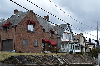
West View is a borough in Allegheny County, Pennsylvania, United States, just north of downtown Pittsburgh. The population was 6,685 at the 2020 census. It is a suburb of the Pittsburgh metropolitan area.

<span class="mw-page-title-main">Burlington, Iowa micropolitan area</span> Micropolitan Statistical Area in the United States

The Burlington, IA−IL Micropolitan Statistical Area, as defined by the United States Census Bureau, is an area consisting of two counties−one in southeast Iowa and the other in West Central Illinois, anchored by the city of Burlington, Iowa.