Pulaski County | |
---|---|
Coordinates: 37°14′N89°08′W / 37.23°N 89.13°W | |
Country | United States |
State | Illinois |
Founded | 1843 |
Named for | Casimir Pulaski |
Seat | Mound City |
Largest city | Mounds |
Area | |
• Total | 203 sq mi (530 km2) |
• Land | 199 sq mi (520 km2) |
• Water | 4.0 sq mi (10 km2) 2.0% |
Population (2020) | |
• Total | 5,193 |
• Estimate (2023) | 4,911 |
• Density | 26/sq mi (9.9/km2) |
Time zone | UTC−6 (Central) |
• Summer (DST) | UTC−5 (CDT) |
Congressional district | 12th |
Website | www |
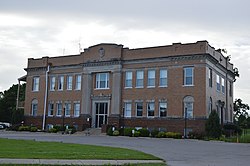
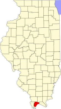
Pulaski County is a county located in the U.S. state of Illinois. According to the 2020 census, it had a population of 5,193. [1] Its county seat is Mound City. [2] Its largest city is Mounds. It is located along the Ohio River in the southwestern portion of the state, known locally as "Little Egypt".
Pulaski County was formed on March 3, 1843, out of parts of Alexander and Johnson counties. It was named in honor of Casimir Pułaski who was killed at the siege of Savannah in the Revolutionary War. [3]
According to the U.S. Census Bureau, the county has a total area of 203 square miles (530 km2), of which 199 square miles (520 km2) is land and 4.0 square miles (10 km2) (2.0%) is water. [4] It is the third-smallest county in Illinois by area.
Mound City, Illinois | ||||||||||||||||||||||||||||||||||||||||||||||||||||||||||||
---|---|---|---|---|---|---|---|---|---|---|---|---|---|---|---|---|---|---|---|---|---|---|---|---|---|---|---|---|---|---|---|---|---|---|---|---|---|---|---|---|---|---|---|---|---|---|---|---|---|---|---|---|---|---|---|---|---|---|---|---|
Climate chart (explanation) | ||||||||||||||||||||||||||||||||||||||||||||||||||||||||||||
| ||||||||||||||||||||||||||||||||||||||||||||||||||||||||||||
|
In recent years, average temperatures in the county seat of Mound City have ranged from a low of 26 °F (−3 °C) in January to a high of 90 °F (32 °C) in July, although a record low of −12 °F (−24 °C) was recorded in January 1985 and a record high of 104 °F (40 °C) was recorded in June 1954. Average monthly precipitation ranged from 3.04 inches (77 mm) in September to 4.76 inches (121 mm) in May. [5]
Census | Pop. | Note | %± |
---|---|---|---|
1850 | 2,265 | — | |
1860 | 3,943 | 74.1% | |
1870 | 8,752 | 122.0% | |
1880 | 9,507 | 8.6% | |
1890 | 11,355 | 19.4% | |
1900 | 14,554 | 28.2% | |
1910 | 15,650 | 7.5% | |
1920 | 14,629 | −6.5% | |
1930 | 14,834 | 1.4% | |
1940 | 15,875 | 7.0% | |
1950 | 13,639 | −14.1% | |
1960 | 10,490 | −23.1% | |
1970 | 8,741 | −16.7% | |
1980 | 8,840 | 1.1% | |
1990 | 7,523 | −14.9% | |
2000 | 7,348 | −2.3% | |
2010 | 6,161 | −16.2% | |
2020 | 5,193 | −15.7% | |
2023 (est.) | 4,911 | [7] | −5.4% |
U.S. Decennial Census [8] 1790-1960 [9] 1900-1990 [10] 1990-2000 [11] 2010-2020 [12] 2020 [1] |
As of the 2010 census, there were 6,161 people, 2,642 households, and 1,658 families living in the county. [13] The population density was 30.9 inhabitants per square mile (11.9/km2). There were 3,155 housing units at an average density of 15.8 per square mile (6.1/km2). [4] The racial makeup of the county was 64.4% white, 32.4% black or African American, 0.4% American Indian, 0.2% Asian, 0.7% from other races, and 1.9% from two or more races. Those of Hispanic or Latino origin made up 1.6% of the population. [13] In terms of ancestry, 15.1% were German, 6.8% were Irish, 6.6% were English, and 6.6% were American. [14]
Of the 2,642 households, 27.3% had children under the age of 18 living with them, 43.6% were married couples living together, 14.3% had a female householder with no husband present, 37.2% were non-families, and 33.4% of all households were made up of individuals. The average household size was 2.32 and the average family size was 2.96. The median age was 43.2 years. [13]
The median income for a household in the county was $31,173 and the median income for a family was $39,699. Males had a median income of $36,915 versus $29,007 for females. The per capita income for the county was $18,444. About 16.7% of families and 22.7% of the population were below the poverty line, including 32.0% of those under age 18 and 18.0% of those age 65 or over. [15]
Pulaski County was often a swing county at the presidential level, but has voted for the Republican candidates for U.S. president since 2012.
This trend in Pulaski County has begun to affect down-ballot races as well. In the 2020 Senate election, longtime Democratic Senator Dick Durbin lost the county for the first time in his career, after winning it in his four prior elections. [16]
Year | Republican | Democratic | Third party(ies) | |||
---|---|---|---|---|---|---|
No. | % | No. | % | No. | % | |
2024 | 1,583 | 66.35% | 769 | 32.23% | 34 | 1.42% |
2020 | 1,699 | 64.58% | 891 | 33.87% | 41 | 1.56% |
2016 | 1,675 | 61.24% | 962 | 35.17% | 98 | 3.58% |
2012 | 1,564 | 51.93% | 1,389 | 46.12% | 59 | 1.96% |
2008 | 1,593 | 48.72% | 1,638 | 50.09% | 39 | 1.19% |
2004 | 1,720 | 55.34% | 1,372 | 44.14% | 16 | 0.51% |
2000 | 1,430 | 47.41% | 1,518 | 50.33% | 68 | 2.25% |
1996 | 1,036 | 36.82% | 1,524 | 54.16% | 254 | 9.03% |
1992 | 1,169 | 32.94% | 1,987 | 55.99% | 393 | 11.07% |
1988 | 1,666 | 47.90% | 1,793 | 51.55% | 19 | 0.55% |
1984 | 1,923 | 52.48% | 1,724 | 47.05% | 17 | 0.46% |
1980 | 2,083 | 50.82% | 1,955 | 47.69% | 61 | 1.49% |
1976 | 1,836 | 42.26% | 2,489 | 57.28% | 20 | 0.46% |
1972 | 2,485 | 59.27% | 1,683 | 40.14% | 25 | 0.60% |
1968 | 1,741 | 37.59% | 2,076 | 44.82% | 815 | 17.59% |
1964 | 1,716 | 33.99% | 3,332 | 66.01% | 0 | 0.00% |
1960 | 2,621 | 52.83% | 2,322 | 46.81% | 18 | 0.36% |
1956 | 2,966 | 56.74% | 2,246 | 42.97% | 15 | 0.29% |
1952 | 3,447 | 58.88% | 2,397 | 40.95% | 10 | 0.17% |
1948 | 2,658 | 52.81% | 2,344 | 46.57% | 31 | 0.62% |
1944 | 3,248 | 58.02% | 2,311 | 41.28% | 39 | 0.70% |
1940 | 4,589 | 56.76% | 3,456 | 42.75% | 40 | 0.49% |
1936 | 3,774 | 49.37% | 3,804 | 49.76% | 67 | 0.88% |
1932 | 3,225 | 47.95% | 3,446 | 51.23% | 55 | 0.82% |
1928 | 3,319 | 65.18% | 1,726 | 33.90% | 47 | 0.92% |
1924 | 3,355 | 61.57% | 1,700 | 31.20% | 394 | 7.23% |
1920 | 4,002 | 62.85% | 2,276 | 35.74% | 90 | 1.41% |
1916 | 3,863 | 62.72% | 2,159 | 35.05% | 137 | 2.22% |
1912 | 1,632 | 51.27% | 978 | 30.73% | 573 | 18.00% |
1908 | 2,185 | 65.24% | 1,080 | 32.25% | 84 | 2.51% |
1904 | 2,180 | 70.71% | 792 | 25.69% | 111 | 3.60% |
1900 | 2,039 | 64.79% | 1,077 | 34.22% | 31 | 0.99% |
1896 | 2,081 | 63.97% | 1,152 | 35.41% | 20 | 0.61% |
1892 | 1,662 | 63.22% | 897 | 34.12% | 70 | 2.66% |
DeWitt County is a county located in the U.S. state of Illinois. As of the 2020 census, the population was 15,516. Its county seat is Clinton. The county was formed on March 1, 1839, from Macon and McLean counties. The county was named in honor of the seventh Governor of New York State, DeWitt Clinton.
Putnam County is the least extensive county in the U.S. state of Illinois. According to the 2020 census, it had a population of 5,637. The county seat is Hennepin. The county was formed in 1825 out of Fulton County and named after Israel Putnam, who was a general in the American Revolution. Putnam County is part of the Ottawa, IL Micropolitan Statistical Area.
Pulaski County is a county located in the southwestern part of the U.S. state of Virginia. As of the 2020 census, the population was 33,800. Its county seat is Pulaski. Pulaski County is part of the Blacksburg–Christiansburg, VA Metropolitan Statistical Area.
Williams County is a county located in the U.S. state of Ohio. As of the 2020 census, the population was 37,102. Its county seat is Bryan. The county was created in 1820 and later organized in 1824. It is named for David Williams, one of the captors of John André in the American Revolutionary War.
Rockcastle County is a county located in the southeastern part of the U.S. state of Kentucky. As of the 2020 census, the population was 16,037. Its county seat is Mt. Vernon.
Lincoln County is a county located in south-central Kentucky. As of the 2020 census, the population was 24,275. Its county seat is Stanford. Lincoln County is part of the Danville, KY Micropolitan Statistical Area.
Ballard County is a county located in the west portion of the U.S. state of Kentucky. As of the 2020 census, the population was 7,728. Its county seat is Wickliffe and its largest city is LaCenter. The county was created by the Kentucky State Legislature in 1842 and is named for Captain Bland Ballard, a soldier, statesman, and member of the Kentucky General Assembly. Ballard County is part of the Paducah, KY-IL Metropolitan Statistical Area.
Pulaski County is a county located in the U.S. state of Indiana. According to the 2020 U.S. census, the population was 12,514. The county seat is Winamac.
Wayne County is a county located in the U.S. state of Illinois. According to the 2020 census, it had a population of 16,179. Its county seat is Fairfield. It is located in the southern portion of Illinois known locally as "Little Egypt".
Union County is a county located in the U.S. state of Illinois. According to the 2020 United States Census, it had a population of 17,244. Its county seat is Jonesboro. It is located in the southern portion of Illinois known locally as "Little Egypt".
Scott County is a county located in the U.S. state of Illinois. According to the 2020 census, it had a population of 4,949, making it the fourth-least populous county in Illinois. Its county seat is Winchester.
Saline County is a county in Southern Illinois. At the 2020 census, it had a population of 23,768. The largest city and county seat is Harrisburg. This area of Southern Illinois is known locally as "Little Egypt".
McDonough County is a county in the U.S. state of Illinois. According to the 2020 census, it had a population of 27,238. Its county seat is Macomb, which is also the home of Western Illinois University.
Logan County is a county located in the U.S. state of Illinois. According to the 2020 census, it had a population of 27,987. Its county seat is Lincoln.
Johnson County is a county in the U.S. state of Illinois. According to the 2020 census, it has a population of 13,308. Its county seat is Vienna. It is located in the southern portion of Illinois known locally as "Little Egypt".
Effingham County is a county located in the south central part of the U.S. state Illinois. As of the 2020 census, the population was 34,668. Its county seat and largest city is Effingham. Some other cities in Effingham County, Illinois include Altamont, Teutopolis, Beecher City, Montrose, Dieterich, Shumway, Watson, Mason, and Edgewood. Effingham County comprises the Effingham, IL Micropolitan Statistical Area.
Alexander County is the southernmost county in the U.S. state of Illinois. As of the 2020 census, the population was 5,240. Its county seat is Cairo and its western boundary is formed by the Mississippi River.
Mound City is a city and the county seat of Pulaski County, Illinois, United States. It is located along the Ohio River just north of its confluence with the Mississippi River. As of the 2010 census, the city population was 588.
Mounds is a city in Pulaski County, Illinois, United States. The population was 661 in the 2020 census.
Pulaski is a village in Pulaski County, Illinois, United States. The population was 235 at the 2010 census. The village is named in honor of Polish Revolutionary War hero Casimir Pulaski.