Christian County | |
---|---|
Coordinates: 39°33′N89°17′W / 39.55°N 89.28°W | |
Country | United States |
State | Illinois |
Founded | 1839 |
Named for | Christian County, Kentucky |
Seat | Taylorville |
Largest city | Taylorville |
Area | |
• Total | 716 sq mi (1,850 km2) |
• Land | 709 sq mi (1,840 km2) |
• Water | 6.3 sq mi (16 km2) 0.9% |
Population (2020) | |
• Total | 34,032 |
• Density | 48/sq mi (18/km2) |
Time zone | UTC−6 (Central) |
• Summer (DST) | UTC−5 (CDT) |
Congressional district | 15th |
Website | christiancountyil |
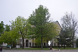
Christian County is a county located in the U.S. state of Illinois. As of the 2020 census, the population was 34,032. [1] Its county seat is Taylorville. [2]
Christian County was formed February 15, 1839, out of Sangamon, Montgomery and Shelby counties. It was named for Christian County, Kentucky. It was originally named Dane County and was called Dane County until 1840. [3]
According to the U.S. Census Bureau, the county has a total area of 716 square miles (1,850 km2), of which 709 square miles (1,840 km2) is land and 6.3 square miles (16 km2) (0.9%) is water. [4] The county is bounded on the north by Sangamon River, and intersected by the south fork of that stream. [5]
Taylorville, Illinois | ||||||||||||||||||||||||||||||||||||||||||||||||||||||||||||
---|---|---|---|---|---|---|---|---|---|---|---|---|---|---|---|---|---|---|---|---|---|---|---|---|---|---|---|---|---|---|---|---|---|---|---|---|---|---|---|---|---|---|---|---|---|---|---|---|---|---|---|---|---|---|---|---|---|---|---|---|
Climate chart (explanation) | ||||||||||||||||||||||||||||||||||||||||||||||||||||||||||||
| ||||||||||||||||||||||||||||||||||||||||||||||||||||||||||||
|
In recent years, average temperatures in the county seat of Taylorville have ranged from a low of 16 °F (−9 °C) in January to a high of 86 °F (30 °C) in July, although a record low of −23 °F (−31 °C) was recorded in January 1994 and a record high of 104 °F (40 °C) was recorded in August 1988. Average monthly precipitation ranged from 1.78 inches (45 mm) in January to 3.77 inches (96 mm) in May. [6]
Census | Pop. | Note | %± |
---|---|---|---|
1840 | 1,878 | — | |
1850 | 3,203 | 70.6% | |
1860 | 10,492 | 227.6% | |
1870 | 20,363 | 94.1% | |
1880 | 28,227 | 38.6% | |
1890 | 30,531 | 8.2% | |
1900 | 32,790 | 7.4% | |
1910 | 34,594 | 5.5% | |
1920 | 38,458 | 11.2% | |
1930 | 37,538 | −2.4% | |
1940 | 38,564 | 2.7% | |
1950 | 38,816 | 0.7% | |
1960 | 37,207 | −4.1% | |
1970 | 35,948 | −3.4% | |
1980 | 36,446 | 1.4% | |
1990 | 34,418 | −5.6% | |
2000 | 35,372 | 2.8% | |
2010 | 34,800 | −1.6% | |
2020 | 34,032 | −2.2% | |
2023 (est.) | 33,228 | [7] | −2.4% |
U.S. Decennial Census [8] 1790-1960 [9] 1900-1990 [10] 1990-2000 [11] 2010 [12] |
As of the 2010 United States Census, there were 34,800 people, 14,055 households, and 9,211 families residing in the county. [13] The population density was 49.1 inhabitants per square mile (19.0/km2). There were 15,563 housing units at an average density of 21.9 per square mile (8.5/km2). [4] The racial makeup of the county was 96.6% white, 1.4% black or African American, 0.5% Asian, 0.1% American Indian, 0.4% from other races, and 0.9% from two or more races. Those of Hispanic or Latino origin made up 1.4% of the population. [13] In terms of ancestry, 21.9% were German, 12.7% were Irish, 10.6% were American, and 9.9% were English. [14]
Of the 14,055 households, 30.1% had children under the age of 18 living with them, 50.1% were married couples living together, 10.3% had a female householder with no husband present, 34.5% were non-families, and 29.9% of all households were made up of individuals. The average household size was 2.36 and the average family size was 2.90. The median age was 41.6 years. [13]
The median income for a household in the county was $41,712 and the median income for a family was $52,680. Males had a median income of $42,897 versus $30,027 for females. The per capita income for the county was $21,519. About 12.7% of families and 16.6% of the population were below the poverty line, including 28.6% of those under age 18 and 9.4% of those age 65 or over. [15]
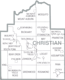
Christian County is divided into these seventeen townships:
Like most of German-settled Central Illinois, Christian County was solidly Democratic until Woodrow Wilson’s response to German defeat in World War I turned the county over to the Republican Party in its 1920, 1924 and 1928 landslides. The county remained Democratic-leaning through the rest of the twentieth century, only voting Republican in landslide wins. However, since 2000 Christian County has become reliably Republican.
Year | Republican | Democratic | Third party | |||
---|---|---|---|---|---|---|
No. | % | No. | % | No. | % | |
2020 | 11,563 | 71.24% | 4,335 | 26.71% | 333 | 2.05% |
2016 | 10,543 | 68.12% | 3,992 | 25.79% | 942 | 6.09% |
2012 | 8,885 | 60.33% | 5,494 | 37.31% | 348 | 2.36% |
2008 | 7,872 | 51.94% | 6,918 | 45.65% | 365 | 2.41% |
2004 | 9,044 | 59.24% | 6,112 | 40.03% | 111 | 0.73% |
2000 | 7,537 | 51.03% | 6,799 | 46.03% | 435 | 2.94% |
1996 | 5,563 | 37.49% | 7,431 | 50.08% | 1,843 | 12.42% |
1992 | 5,087 | 28.92% | 9,042 | 51.40% | 3,461 | 19.68% |
1988 | 7,040 | 45.61% | 8,295 | 53.74% | 101 | 0.65% |
1984 | 8,534 | 52.84% | 7,541 | 46.69% | 77 | 0.48% |
1980 | 8,770 | 54.69% | 6,625 | 41.31% | 641 | 4.00% |
1976 | 7,445 | 43.90% | 9,306 | 54.87% | 209 | 1.23% |
1972 | 10,072 | 56.98% | 7,556 | 42.75% | 47 | 0.27% |
1968 | 7,486 | 42.31% | 8,465 | 47.84% | 1,743 | 9.85% |
1964 | 6,153 | 34.09% | 11,898 | 65.91% | 0 | 0.00% |
1960 | 9,263 | 47.54% | 10,207 | 52.38% | 15 | 0.08% |
1956 | 10,282 | 52.91% | 9,093 | 46.79% | 59 | 0.30% |
1952 | 9,906 | 50.11% | 9,844 | 49.80% | 17 | 0.09% |
1948 | 7,576 | 44.40% | 9,366 | 54.89% | 120 | 0.70% |
1944 | 8,995 | 48.79% | 9,360 | 50.77% | 82 | 0.44% |
1940 | 10,255 | 46.91% | 11,457 | 52.41% | 150 | 0.69% |
1936 | 8,145 | 39.69% | 11,400 | 55.55% | 976 | 4.76% |
1932 | 6,096 | 33.42% | 11,515 | 63.12% | 631 | 3.46% |
1928 | 9,896 | 56.77% | 7,345 | 42.14% | 190 | 1.09% |
1924 | 7,398 | 46.08% | 5,826 | 36.29% | 2,832 | 17.64% |
1920 | 7,535 | 52.75% | 5,398 | 37.79% | 1,352 | 9.46% |
1916 | 6,923 | 44.12% | 7,982 | 50.87% | 787 | 5.02% |
1912 | 1,994 | 25.30% | 3,821 | 48.48% | 2,067 | 26.22% |
1908 | 3,686 | 43.63% | 4,156 | 49.19% | 607 | 7.18% |
1904 | 3,856 | 49.15% | 3,297 | 42.02% | 693 | 8.83% |
1900 | 3,686 | 43.59% | 4,519 | 53.44% | 252 | 2.98% |
1896 | 3,857 | 44.74% | 4,639 | 53.82% | 124 | 1.44% |
1892 | 2,941 | 40.12% | 3,655 | 49.86% | 735 | 10.03% |
Montgomery County is a county located in the U.S. state of Illinois. According to the 2020 census, it had a population of 28,288. Its county seat is Hillsboro.
Sangamon County is a county located in the center of the U.S. state of Illinois. According to the 2020 census, it had a population of 196,343. Its county seat and largest city is Springfield, the state capital.
Menard County is a county in the U.S. state of Illinois. According to the 2020 United States Census, it had a population of 12,297. Its county seat is Petersburg. Menard County is part of the Springfield, Illinois, IL Metropolitan Statistical Area.
Cass County is a county located in the U.S. state of Illinois. As of the 2020 United States Census, the population was 13,042. Its county seat is Virginia. It is the home of the Jim Edgar Panther Creek State Fish and Wildlife Area.
Taylorville is a city in and the county seat of Christian County, Illinois, United States. The population was 10,506 at the 2020 census, making it the county's largest city.
Blue Mound is a village in Macon County, Illinois, United States. The population was 1,133 at the 2020 census. It is included in the Decatur, Illinois Metropolitan Statistical Area.
Petersburg is a city in and the county seat of Menard County, Illinois, United States, on the bluffs and part of the floodplain overlooking the Sangamon River. It is part of the Springfield, Illinois Metropolitan Statistical Area. The population was 2,258 at the 2020 census, nearly unchanged from 2010. Petersburg is located approximately 2 miles (3 km) north of New Salem, the original location where Abraham Lincoln first settled, as he started his career.
Dawson is a village in Sangamon County, Illinois, United States. The population was 519 at the 2020 census. It is about 10 miles (16 km) east of Springfield and is part of the Springfield Metropolitan Statistical Area.
New Berlin is a village in Sangamon County, Illinois, United States. The population was 1,346 at the 2010 census, and 1,327 at a 2018 estimate. It is part of the Springfield Metropolitan Statistical Area. New Berlin is home to CUSD #16, New Berlin High School.
Southern View is a village in Sangamon County, Illinois, United States. The population was 1,642 at the 2010 census. It is part of the Springfield, Illinois Metropolitan Statistical Area.
Sangamon Valley Township is one of eleven townships in Cass County, Illinois, USA. As of the 2020 census, its population was 330 and it contained 160 housing units.
Bear Creek Township is one of seventeen townships in Christian County, Illinois, United States. At the time of the 2020 census, its population was 516, and it contained 227 housing units.
Greenwood Township is one of seventeen townships in Christian County, Illinois, USA. As of the 2020 census, its population was 200 and it contained 95 housing units.
Locust Township is one of seventeen townships in Christian County, Illinois, USA. As of the 2020 census, its population was 3,137 and it contained 249 housing units.
May Township is one of seventeen townships in Christian County, Illinois, USA. As of the 2020 census, its population was 1,760 and it contained 774 housing units.
Mosquito Township is one of seventeen townships in Christian County, Illinois, USA. As of the 2020 census, its population was 346 and it contained 160 housing units.
Pana Township is one of seventeen townships in Christian County, Illinois, USA. As of the 2020 census, its population was 6,031 and it contained 3,002 housing units.
South Fork Township is one of seventeen townships in Christian County, Illinois, USA. As of the 2020 census, its population was 2,565, and it contained 1,242 housing units.
Stonington Township is one of seventeen townships in Christian County, Illinois, USA. As of the 2020 census, its population was 993 and it contained 467 housing units.
Taylorville Township is one of seventeen townships in Christian County, Illinois, USA. As of the 2020 census, its population was 11,539 and it contained 5,801 housing units.