Mount Auburn, Illinois

Last updated

Mount Auburn
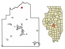
Christian County Illinois Incorporated and Unincorporated areas Mount Auburn Highlighted.svg
Location of Mount Auburn in Christian County, Illinois.
Coordinates: 39°45′54″N89°15′39″W / 39.76500°N 89.26083°W / 39.76500; -89.26083 [1]
CountryUnited States
StateIllinois
County Christian
Government
  MayorMike Whitehead [2]
Area
[3]
  Total
1.00 sq mi (2.58 km2)
  Land1.00 sq mi (2.58 km2)
  Water0.00 sq mi (0.00 km2)
Elevation
[1]
679 ft (207 m)
Population
 (2020)
  Total
452
  Density453.36/sq mi (175.09/km2)
Time zone UTC-6 (CST)
  Summer (DST) UTC-5 (CDT)
ZIP Code(s)
62547
Area code 217
FIPS code 17-50829
GNIS ID2399406 [1]

Mount Auburn is a village in Christian County, Illinois, United States. The population was 452 at the 2020 census.

Contents

History

Mount Auburn was founded on July 11, 1839. It was seriously considered as possibility for the state capital at the time the center of government was moved from Vandalia to Springfield.[ citation needed ]

Geography

According to the 2021 census gazetteer files, Mount Auburn has a total area of 1.00 square mile (2.59 km2), of which 1.00 square mile (2.59 km2) (or 99.90%) is land and 0.00 square miles (0.00 km2) (or 0.10%) is water. [4]

Demographics

Historical population
CensusPop.Note
1880 208
1890 2226.7%
1900 2355.9%
1910 46397.0%
1920 4926.3%
1930 380−22.8%
1940 47123.9%
1950 414−12.1%
1960 50221.3%
1970 5203.6%
1980 59815.0%
1990 544−9.0%
2000 515−5.3%
2010 480−6.8%
2020 452−5.8%
U.S. Decennial Census [5]

As of the 2020 census [6] there were 452 people, 273 households, and 172 families residing in the village. The population density was 452.91 inhabitants per square mile (174.87/km2). There were 215 housing units at an average density of 215.43 per square mile (83.18/km2). The racial makeup of the village was 93.14% White, 0.22% African American, 0.66% Asian, 1.33% from other races, and 4.65% from two or more races. Hispanic or Latino of any race were 0.66% of the population.

There were 273 households, out of which 40.3% had children under the age of 18 living with them, 58.61% were married couples living together, 1.83% had a female householder with no husband present, and 37.00% were non-families. 27.11% of all households were made up of individuals, and 12.45% had someone living alone who was 65 years of age or older. The average household size was 2.91 and the average family size was 2.36.

The village's age distribution consisted of 22.8% under the age of 18, 5.9% from 18 to 24, 39.2% from 25 to 44, 23.3% from 45 to 64, and 8.9% who were 65 years of age or older. The median age was 38.7 years. For every 100 females, there were 119.0 males. For every 100 females age 18 and over, there were 95.7 males.

The median income for a household in the village was $49,904, and the median income for a family was $67,717. Males had a median income of $31,250 versus $29,479 for females. The per capita income for the village was $22,930. About 4.1% of families and 9.0% of the population were below the poverty line, including none of those under age 18 and 7.0% of those age 65 or over.

References

  1. 1 2 3 U.S. Geological Survey Geographic Names Information System: Mount Auburn, Illinois
  2. LinkedUpRadio, Envisionwise Website Service /. "Mount Auburn Elects New Mayor". Taylorville Daily News. Retrieved July 12, 2022.
  3. "2020 U.S. Gazetteer Files". United States Census Bureau. Retrieved March 15, 2022.
  4. "Gazetteer Files". Census.gov. United States Census Bureau. Retrieved June 29, 2022.
  5. "Census of Population and Housing". Census.gov. Retrieved June 4, 2015.
  6. "Explore Census Data". data.census.gov. Retrieved June 28, 2022.