Edgar County, Illinois

Last updated

Edgar County
Edgar County Courthouse from southwest at dusk.jpg
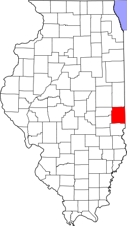
Map of Illinois highlighting Edgar County.svg
Location within the U.S. state of Illinois
Illinois in United States.svg
Illinois's location within the U.S.
Coordinates: 39°41′N87°45′W / 39.68°N 87.75°W / 39.68; -87.75
CountryFlag of the United States.svg United States
StateFlag of Illinois.svg  Illinois
FoundedJanuary 3, 1823
Named for John Edgar
Seat Paris
Largest cityParis
Area
  Total624 sq mi (1,620 km2)
  Land623 sq mi (1,610 km2)
  Water0.6 sq mi (2 km2)  0.1%
Population
 (2020)
  Total16,866
  Density27/sq mi (10/km2)
Time zone UTC−6 (Central)
  Summer (DST) UTC−5 (CDT)
Congressional district 15th
Website www.edgarcountyillinois.com

Edgar County is a county located in the U.S. state of Illinois. As of the 2020 United States Census, the population was 16,866. [1] Its county seat is Paris. [2]

Contents

History

Edgar County was formed out of Clark County in 1823. It was named for John Edgar, [3] an Irish-born officer in the Royal Navy who resigned rather than fight against the Americans in the Revolutionary War. Edgar moved to Kaskaskia, Illinois, in 1784, becoming a miller and merchant in that town.

Geography

According to the US Census Bureau, the county has a total area of 624 square miles (1,620 km2), of which 623 square miles (1,610 km2) is land and 0.6 square miles (1.6 km2) (0.1%) is water. [5]

There is one recreational area in the county, on the north edge of Paris. Twin Lakes Park and Reservoir began in 1895 upon completion of the dam compounding the Twin Lakes Reservoir. [6]

Climate and weather

Paris, Illinois
Climate chart (explanation)
J
F
M
A
M
J
J
A
S
O
N
D
 
 
2.2
 
 
34
16
 
 
2.2
 
 
40
21
 
 
3.3
 
 
51
31
 
 
4
 
 
63
41
 
 
4.3
 
 
74
51
 
 
4.2
 
 
83
61
 
 
4.4
 
 
86
65
 
 
4.4
 
 
84
62
 
 
2.9
 
 
78
55
 
 
2.8
 
 
66
43
 
 
3.7
 
 
51
33
 
 
3.1
 
 
39
22
Average max. and min. temperatures in °F
Precipitation totals in inches
Source: The Weather Channel [7]
Metric conversion
J
F
M
A
M
J
J
A
S
O
N
D
 
 
57
 
 
1
−9
 
 
57
 
 
4
−6
 
 
83
 
 
11
−1
 
 
101
 
 
17
5
 
 
109
 
 
23
11
 
 
108
 
 
28
16
 
 
113
 
 
30
18
 
 
112
 
 
29
17
 
 
75
 
 
26
13
 
 
71
 
 
19
6
 
 
93
 
 
11
1
 
 
79
 
 
4
−6
Average max. and min. temperatures in °C
Precipitation totals in mm

In recent years, average temperatures in the county seat of Paris have ranged from a low of 16 °F (−9 °C) in January to a high of 86 °F (30 °C) in July, although a record low of −23 °F (−31 °C) was recorded in January 1930 and a record high of 109 °F (43 °C) was recorded in July 1936. Average monthly precipitation ranged from 2.23 inches (57 mm) in January to 4.43 inches (113 mm) in July. [7]

Adjacent counties

Transportation

Major highways

Rail

Three railroad lines run through the county. Two are operated by CSX Transportation and the third by the Eastern Illinois Railroad Company. [8]

Transit

Airport

The county contains one public-use airport: Edgar County Airport (PRG), six miles (10 km) north of Paris. [9]

Demographics

Historical population
CensusPop.Note
1830 4,071
1840 8,225102.0%
1850 10,69230.0%
1860 16,92558.3%
1870 21,45026.7%
1880 25,49918.9%
1890 26,7875.1%
1900 28,2735.5%
1910 27,336−3.3%
1920 25,769−5.7%
1930 24,966−3.1%
1940 24,430−2.1%
1950 23,407−4.2%
1960 22,550−3.7%
1970 21,591−4.3%
1980 21,7250.6%
1990 19,595−9.8%
2000 19,7040.6%
2010 18,576−5.7%
2020 16,866−9.2%
2023 (est.)16,334 [10] −3.2%
US Decennial Census [11]
1790-1960 [12] 1900-1990 [13]
1990-2000 [14] 2010-2013 [1]
2000 census age pyramid for Edgar County USA Edgar County, Illinois age pyramid.svg
2000 census age pyramid for Edgar County

As of the 2010 United States Census, there were 18,576 people, 7,839 households, and 5,148 families residing in the county. [15] The population density was 29.8 inhabitants per square mile (11.5/km2). There were 8,803 housing units at an average density of 14.1 per square mile (5.4/km2). [5] The racial makeup of the county was 98.3% white, 0.3% black or African American, 0.2% Asian, 0.1% American Indian, 0.3% from other races, and 0.7% from two or more races. Those of Hispanic or Latino origin made up 1.0% of the population. [15] In terms of ancestry, 23.6% were German, 15.3% were Irish, 13.0% were English, and 12.3% were American. [16]

Of the 7,839 households, 28.5% had children under the age of 18 living with them, 50.3% were married couples living together, 10.7% had a female householder with no husband present, 34.3% were non-families, and 29.5% of all households were made up of individuals. The average household size was 2.33 and the average family size was 2.84. The median age was 43.2 years. [15]

The median income for a household in the county was $39,904 and the median income for a family was $51,588. Males had a median income of $38,945 versus $29,951 for females. The per capita income for the county was $22,175. About 9.7% of families and 13.5% of the population were below the poverty line, including 19.2% of those under age 18 and 7.9% of those age 65 or over. [17]

Communities

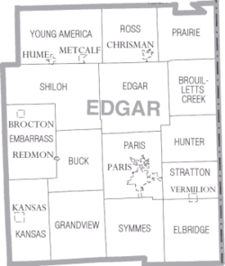
Map of Edgar County Map of Edgar County Illinois.png
Map of Edgar County

Cities

Villages

Unincorporated communities

Former communities

Townships

Notable people

Politics

A swing county in the first eight decades after the Civil War, Edgar County has since become powerfully Republican. It has been carried by only two Democrats since 1940 – Lyndon Johnson in 1964 by just 139 votes, and Bill Clinton in 1992 by a 41.1 percent plurality. Hillary Clinton’s 22.7 percent vote share in 2016 was by 9.3 percent the worst ever by a Democrat in the county.

United States presidential election results for Edgar County, Illinois [43]
Year Republican Democratic Third party
No.%No.%No.%
2020 6,19375.41%1,88722.98%1321.61%
2016 5,64571.46%1,79322.70%4615.84%
2012 5,13265.50%2,56532.74%1381.76%
2008 4,39853.09%3,74345.18%1431.73%
2004 5,25862.38%3,09336.69%780.93%
2000 4,83358.71%3,21639.07%1832.22%
1996 3,74645.12%3,55242.78%1,00412.09%
1992 3,79038.77%4,01441.06%1,97220.17%
1988 5,53858.55%3,88041.02%410.43%
1984 6,82167.54%3,24132.09%370.37%
1980 6,63963.14%3,39432.28%4824.58%
1976 5,84253.01%5,05845.89%1211.10%
1972 7,19564.73%3,88934.99%320.29%
1968 6,28156.33%3,56531.97%1,30511.70%
1964 5,82749.41%5,96650.59%00.00%
1960 7,34859.37%5,02440.59%40.03%
1956 7,94264.52%4,36235.44%50.04%
1952 8,32364.56%4,55835.36%100.08%
1948 6,28254.77%5,12144.65%670.58%
1944 6,96157.68%5,05441.88%540.45%
1940 7,98554.03%6,71345.42%820.55%
1936 6,92946.51%7,82252.50%1470.99%
1932 5,95343.03%7,74555.98%1381.00%
1928 7,50958.27%5,32541.32%520.40%
1924 6,29752.31%5,22243.38%5184.30%
1920 6,75053.29%5,69444.95%2231.76%
1916 6,09946.37%6,71051.01%3452.62%
1912 2,43032.84%3,47947.02%1,49020.14%
1908 3,75750.46%3,43346.11%2553.43%
1904 3,75350.33%3,44346.17%2613.50%
1900 3,76648.90%3,78349.12%1531.99%
1896 3,82249.80%3,72948.59%1231.60%
1892 3,19747.64%3,16447.15%3505.22%

See also

Related Research Articles

<span class="mw-page-title-main">Clay County, Illinois</span> County in Illinois, United States

Clay County is a county in the southeastern portion of the U.S. state of Illinois. As of the 2020 United States Census, the population was 13,288. Since 1842, its county seat has been Louisville, in the center of the county's area.

<span class="mw-page-title-main">Clay County, Nebraska</span> County in Nebraska, United States

Clay County is a county in the U.S. state of Nebraska. As of the 2020 United States Census, the population was 6,104. Its county seat is Clay Center. The county was formed in 1855, and was organized in 1871. It was named for Henry Clay, a member of the United States Senate from Kentucky, who went on to become United States Secretary of State.

<span class="mw-page-title-main">Valley County, Montana</span> County in Montana, United States

Valley County is a county in the U.S. state of Montana. Valley County was created in 1893 with area partitioned from Dawson County. As of the 2020 census, the population was 7,578. Its county seat is Glasgow. It is located on the Canada–United States border with Saskatchewan.

<span class="mw-page-title-main">Toole County, Montana</span> County in Montana, United States

Toole County is a county in the northern portion of the U.S. state of Montana. As of the 2020 census, the population was 4,971. Its county seat is Shelby. The county was established in 1914 from parts of Hill County and Teton County and was named after Joseph Toole, the first and fourth governor of Montana. Its northern boundary is the Canada–United States border south of Alberta.

<span class="mw-page-title-main">Roosevelt County, Montana</span> County in Montana, United States

Roosevelt County is a county in the U.S. state of Montana. As of the 2020 census, the population was 10,794. Its county seat is Wolf Point. Roosevelt County was created by the Montana Legislature in 1919 from a portion of Sheridan County. The name honors former president Theodore Roosevelt, who had died earlier that year.

<span class="mw-page-title-main">Union County, Kentucky</span> County in Kentucky, United States

Union County is a county in the U.S. state of Kentucky. As of the 2020 census, the population was 13,668. Its county seat is Morganfield. The county was created effective January 15, 1811.

<span class="mw-page-title-main">Union County, Illinois</span> County in Illinois, United States

Union County is a county located in the U.S. state of Illinois. According to the 2020 United States Census, it had a population of 17,244. Its county seat is Jonesboro. It is located in the southern portion of Illinois known locally as "Little Egypt".

<span class="mw-page-title-main">Scott County, Illinois</span> County in Illinois, United States

Scott County is a county located in the U.S. state of Illinois. According to the 2020 census, it had a population of 4,949, making it the fourth-least populous county in Illinois. Its county seat is Winchester.

<span class="mw-page-title-main">Peoria County, Illinois</span> County in Illinois, United States

Peoria County is located in the U.S. state of Illinois. The 2020 United States Census listed its population at 181,830. Its county seat is Peoria. Peoria County is part of the Peoria, IL Metropolitan Statistical Area.

<span class="mw-page-title-main">Jackson County, Illinois</span> County in Illinois, United States

Jackson County is a county located in the U.S. state of Illinois with a population of 52,974 at the 2020 census. Its county seat is Murphysboro, and its most populous city is Carbondale, home to the main campus of Southern Illinois University. The county was incorporated on January 10, 1816, and named for Andrew Jackson. The community of Brownsville served as the fledgling county's first seat.

<span class="mw-page-title-main">Fulton County, Illinois</span> County in Illinois, United States

Fulton County is a county in the U.S. state of Illinois. According to the 2020 census, it had a population of 33,609. Its county seat is Lewistown, and the largest city is Canton. Fulton County comprises the Canton, IL Micropolitan Statistical Area, which is part of the Peoria-Canton, IL Combined Statistical Area.

<span class="mw-page-title-main">Ford County, Illinois</span> County in Illinois, United States

Ford County is a county located in the U.S. state of Illinois. According to the 2020 United States Census, it had a population of 13,534. Its county seat is Paxton. Ford County was part of the Champaign–Urbana, IL Metropolitan Statistical Area until 2018, when the Office of Management and Budget removed the county from the area.

<span class="mw-page-title-main">Douglas County, Illinois</span> County in Illinois, United States

Douglas County is a county located in the U.S. state of Illinois. As of the 2020 United States Census, the population was 19,740. The county seat is Tuscola.

<span class="mw-page-title-main">Cass County, Illinois</span> County in Illinois, United States

Cass County is a county located in the U.S. state of Illinois. As of the 2020 United States Census, the population was 13,042. Its county seat is Virginia. It is the home of the Jim Edgar Panther Creek State Fish and Wildlife Area.

<span class="mw-page-title-main">Bingham County, Idaho</span> County in Idaho, United States

Bingham County is a county in the U.S. state of Idaho. As of the 2020 census, the population was 47,992. The county seat and largest city is Blackfoot.

<span class="mw-page-title-main">Vermilion, Illinois</span> Village in Illinois, United States

Vermilion is a village in Stratton and Elbridge Township townships, Edgar County, Illinois, United States. The population was 203 at the 2020 census.

<span class="mw-page-title-main">Prairie Township, Edgar County, Illinois</span> Township in Illinois, United States

Prairie Township is one of fifteen townships in Edgar County, Illinois, USA. As of the 2020 census, its population was 222 and it contained 107 housing units.

<span class="mw-page-title-main">Grandview Township, Edgar County, Illinois</span> Township in Illinois, United States

Grandview Township is one of fifteen townships in Edgar County, Illinois, USA. As of the 2020 census, its population was 523 and it contained 238 housing units.

<span class="mw-page-title-main">Shiloh Township, Edgar County, Illinois</span> Township in Illinois, United States

Shiloh Township is one of fifteen townships in Edgar County, Illinois, USA. As of the 2020 census, its population was 157 and it contained 70 housing units. Shiloh Township was formed from Young America and Edgar townships.

<span class="mw-page-title-main">Symmes Township, Edgar County, Illinois</span> Township in Illinois, United States

Symmes Township is one of fifteen townships in Edgar County, Illinois, USA. As of the 2020 census, its population was 948 and it contained 447 housing units. The township was called Marion Township until May 9, 1857.

References

  1. 1 2 "State & County QuickFacts". US Census Bureau. Archived from the original on June 6, 2011. Retrieved July 4, 2014.
  2. "Find a County". National Association of Counties. Archived from the original on July 4, 2012. Retrieved June 7, 2011.
  3. Adams, James N. (compiler) (1989), Keller, William E. (ed.), Illinois Place Names , Springfield: Illinois State Historical Society, p.  580, ISBN   0-912226-24-2
  4. White, Jesse. Origin and Evolution of Illinois Counties. State of Illinois, March 2010.
  5. 1 2 "Population, Housing Units, Area, and Density: 2010 - County". US Census Bureau. Archived from the original on February 12, 2020. Retrieved July 11, 2015.
  6. Parks - City of Paris IL (accessed 30 December 2018)
  7. 1 2 "Monthly Averages for Paris IL". The Weather Channel. Retrieved January 27, 2011.
  8. Illinois Railroad Map (PDF), archived from the original (PDF) on August 22, 2007, retrieved October 11, 2007
  9. Public and Private Airports, Edgar County IL
  10. "Annual Estimates of the Resident Population for Counties: April 1, 2020 to July 1, 2023". United States Census Bureau. Retrieved April 2, 2024.
  11. "US Decennial Census". US Census Bureau. Retrieved July 4, 2014.
  12. "Historical Census Browser". University of Virginia Library. Retrieved July 4, 2014.
  13. "Population of Counties by Decennial Census: 1900 to 1990". US Census Bureau. Retrieved July 4, 2014.
  14. "Census 2000 PHC-T-4. Ranking Tables for Counties: 1990 and 2000" (PDF). US Census Bureau. Archived (PDF) from the original on March 27, 2010. Retrieved July 4, 2014.
  15. 1 2 3 "Profile of General Population and Housing Characteristics: 2010 Demographic Profile Data". US Census Bureau. Archived from the original on February 13, 2020. Retrieved July 11, 2015.
  16. "Selected Social Characteristics in the United States – 2006-2010 American Community Survey 5-Year Estimates". US Census Bureau. Archived from the original on February 13, 2020. Retrieved July 11, 2015.
  17. "Selected Economic Characteristics – 2006-2010 American Community Survey 5-Year Estimates". US Census Bureau. Archived from the original on February 13, 2020. Retrieved July 11, 2015.
  18. Bell Ridge, Edgar County IL Google Maps (accessed 30 December 2018)
  19. Bloomfield, Edgar County IL Google Maps (accessed 30 December 2018)
  20. Cherry Point, Edgar County IL Google Maps (accessed 30 December 2018)
  21. Clays Prairie, Edgar County IL Google Maps (accessed 30 December 2018)
  22. Conlogue, Edgar County IL Google Maps (accessed 30 December 2018)
  23. Dudley, Edgar County IL Google Maps (accessed 30 December 2018)
  24. Ferrel, Edgar County IL Google Maps (accessed 30 December 2018)
  25. Garland, Edgar County IL Google Maps (accessed 30 December 2018)
  26. Harris, Edgar County IL Google Maps (accessed 30 December 2018)
  27. Hildreth, Edgar County IL Google Maps (accessed 30 December 2018)
  28. Horace, Edgar County IL Google Maps (accessed 30 December 2018)
  29. Huffmanville, Edgar County IL Google Maps (accessed 30 December 2018)
  30. Hughes, Edgar County IL Google Maps (accessed 30 December 2018)
  31. Kentucky, Edgar County IL Google Maps (accessed 30 December 2018)
  32. Kidley, Edgar County IL Google Maps (accessed 30 December 2018)
  33. Logan, Edgar County IL Google Maps (accessed 30 December 2018)
  34. Mabel, Edgar County IL Google Maps (accessed 30 December 2018)
  35. Marley, Edgar County IL Google Maps (accessed 30 December 2018)
  36. Mays, Edgar County IL Google Maps (accessed 30 December 2018)
  37. McCown, Edgar County IL Google Maps (accessed 30 December 2018)
  38. Melwood, Edgar County IL Google Maps (accessed 30 December 2018)
  39. Mortimer, Edgar County IL Google Maps (accessed 30 December 2018)
  40. Palermo, Edgar County IL Google Maps (accessed 30 December 2018)
  41. Scotts, Edgar County IL Google Maps (accessed 30 December 2018
  42. Warrington, Edgar County IL Google Maps (accessed 30 December 2018)
  43. Leip, David. "Atlas of US Presidential Elections". uselectionatlas.org. Retrieved November 1, 2018.

39°41′N87°45′W / 39.68°N 87.75°W / 39.68; -87.75