Randolph County, Illinois

Last updated

Randolph County
Randolph County Courthouse, Chester.jpg
Motto: 
Where Illinois Began
Map of Illinois highlighting Randolph County.svg
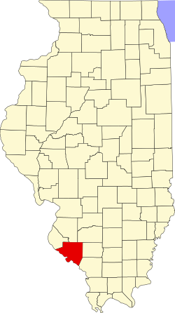
Location within the U.S. state of Illinois
Illinois in United States.svg
Illinois's location within the U.S.
Coordinates: 38°03′N89°49′W / 38.05°N 89.82°W / 38.05; -89.82
CountryFlag of the United States.svg United States
StateFlag of Illinois.svg  Illinois
Founded1795
Named for Edmund Randolph
Seat Chester
Largest cityChester
Area
  Total597 sq mi (1,550 km2)
  Land576 sq mi (1,490 km2)
  Water22 sq mi (60 km2)  3.6%
Population
 (2020)
  Total30,163
  Density51/sq mi (20/km2)
Time zone UTC−6 (Central)
  Summer (DST) UTC−5 (CDT)
Congressional district 12th
Website am.randolphco.org

Randolph County is a county located in the U.S. state of Illinois. According to the 2020 census, it had a population of 30,163. [1] Its county seat is Chester. [2]

Contents

Owing to its role in the state's history, the county motto is "Where Illinois Began." It contains the historically important village of Kaskaskia, Illinois's first capital.

The county is part of Southern Illinois in the southern portion of the state known locally as "Little Egypt", and includes fertile river flats, part of the American Bottom; it is near the Greater St. Louis area.

History

Randolph County was organized in 1795 out of a part of St. Clair County. It was named in honor of Edmund Randolph, Governor of Virginia. George Rogers Clark of the army of Virginia captured the area from the British on July 4, 1778, near the end of the Revolutionary War. The area then became the seat, for several years, of Illinois County, Virginia, although the Congress of the Confederation legislated the existence of the Northwest Territory on July 13, 1787. Edmund Randolph was Governor of Virginia at the time Virginia ceded the Northwest Territory to the United States. In 1809, when Illinois became a separate territory, Territorial Secretary Nathaniel Pope, in his capacity as acting governor, issued a proclamation establishing Randolph as one of the Illinois' two original counties. The county's boundaries were last changed in 1827, when land was taken to form Perry County.

The Mississippi River has played a prominent role in the county's history, altering its boundaries in 1881 when it severed the isthmus that connected Kaskaskia to the Illinois mainland, destroying the original village of Kaskaskia and forcing its historic cemetery to be relocated across the river to Fort Kaskaskia. Crains Island, [3] southeast of Chester, is another enclave of Illinois west of the Mississippi that was created by a change in the river's course.

Geography

According to the U.S. Census Bureau, the county has a total area of 597 square miles (1,550 km2), of which 576 square miles (1,490 km2) is land and 22 square miles (57 km2) (3.6%) is water. [5]

The Kaskaskia River flows into the Mississippi River in Randolph County. At this point the Mississippi, which usually defines the border between Illinois and Missouri, is entirely in Illinois. The Mississippi changed its course in the late-nineteenth century, leaving Kaskaskia, the former state capital, on the west side of the river. The boundary of the State, however, follows the old course of the river, leaving Illinois with an exclave on the western shore of the Mississippi River. A smaller enclave, Crains Island, is a few miles further down the river.

Climate and weather

Chester, Illinois
Climate chart (explanation)
J
F
M
A
M
J
J
A
S
O
N
D
 
 
1.9
 
 
39
22
 
 
2
 
 
46
26
 
 
3.5
 
 
56
35
 
 
3.4
 
 
68
45
 
 
4.3
 
 
78
54
 
 
3.9
 
 
87
64
 
 
3.8
 
 
91
68
 
 
3.4
 
 
89
66
 
 
3.2
 
 
82
58
 
 
3.1
 
 
71
46
 
 
4.2
 
 
56
36
 
 
3.2
 
 
44
27
Average max. and min. temperatures in °F
Precipitation totals in inches
Source: The Weather Channel [6]
Metric conversion
J
F
M
A
M
J
J
A
S
O
N
D
 
 
47
 
 
4
−6
 
 
51
 
 
8
−3
 
 
89
 
 
13
2
 
 
87
 
 
20
7
 
 
109
 
 
26
12
 
 
98
 
 
31
18
 
 
96
 
 
33
20
 
 
86
 
 
32
19
 
 
81
 
 
28
14
 
 
78
 
 
22
8
 
 
106
 
 
13
2
 
 
80
 
 
7
−3
Average max. and min. temperatures in °C
Precipitation totals in mm

In recent years, average temperatures in the county seat of Chester have ranged from a low of 22 °F (−6 °C) in January to a high of 91 °F (33 °C) in July, although a record low of −18 °F (−28 °C) was recorded in January 1985 and a record high of 113 °F (45 °C) was recorded in July 2012. Average monthly precipitation ranged from 1.85 inches (47 mm) in January to 4.30 inches (109 mm) in May. [6]

Major highways

Adjacent counties

Randolph County is among the few counties in the United States to border two counties with the same name (Perry County in Missouri and Illinois).

Demographics

Historical population
CensusPop.Note
1820 3,492
1830 4,42926.8%
1840 7,94479.4%
1850 11,07939.5%
1860 17,20555.3%
1870 20,85921.2%
1880 25,69023.2%
1890 25,049−2.5%
1900 28,00111.8%
1910 29,1204.0%
1920 29,1090.0%
1930 29,3130.7%
1940 33,60814.7%
1950 31,673−5.8%
1960 29,988−5.3%
1970 31,3794.6%
1980 35,65213.6%
1990 34,583−3.0%
2000 33,893−2.0%
2010 33,476−1.2%
2020 30,163−9.9%
2023 (est.)29,815 [7] −1.2%
U.S. Decennial Census [8]
1790–1960 [9] 1900–1990 [10]
1990–2000 [11] 2010–2013 [12] 2020 United States census

As of the 2010 United States Census, there were 33,476 people, 12,314 households, and 8,188 families residing in the county. [13] The population density was 58.2 inhabitants per square mile (22.5/km2). There were 13,707 housing units at an average density of 23.8 per square mile (9.2/km2). [5] The racial makeup of the county was 87.6% white, 9.7% black or African American, 0.3% Asian, 0.2% American Indian, 1.2% from other races, and 0.9% from two or more races. Those of Hispanic or Latino origin made up 2.6% of the population. [13] In terms of ancestry, 40.3% were German, 11.3% were Irish, 9.4% were English, and 5.7% were American. [14]

Of the 12,314 households, 29.1% had children under the age of 18 living with them, 52.0% were married couples living together, 10.1% had a female householder with no husband present, 33.5% were non-families, and 28.9% of all households were made up of individuals. The average household size was 2.37 and the average family size was 2.90. The median age was 41.0 years. [13]

The median income for a household in the county was $45,020 and the median income for a family was $55,113. Males had a median income of $43,359 versus $28,376 for females. The per capita income for the county was $19,950. About 7.0% of families and 10.4% of the population were below the poverty line, including 11.9% of those under age 18 and 9.9% of those age 65 or over. [15]

Government and infrastructure

The Illinois Department of Corrections Menard Correctional Center is located in Chester. [16] [17] Prior to the January 11, 2003 commutation of death row sentences, male death row inmates were housed in Menard, Tamms, and Pontiac correctional centers. After that date, only Pontiac continued to host the male death row. [18]

Politics

Randolph is a rural conservative county in southern Illinois that has trended Republican since 2000 in presidential elections.

United States presidential election results for Randolph County, Illinois [19]
Year Republican Democratic Third party
No.%No.%No.%
2020 11,07674.29%3,59224.09%2421.62%
2016 10,02370.61%3,43924.23%7325.16%
2012 8,29057.42%5,75939.89%3892.69%
2008 7,53849.59%7,39548.64%2691.77%
2004 8,07654.00%6,77145.27%1090.73%
2000 7,12749.88%6,79447.55%3662.56%
1996 5,42237.02%7,41950.65%1,80612.33%
1992 4,89929.57%8,52951.49%3,13718.94%
1988 7,39648.28%7,84451.21%780.51%
1984 9,41559.48%6,35540.15%590.37%
1980 8,81056.86%6,05239.06%6324.08%
1976 8,19048.07%8,69351.02%1550.91%
1972 9,76160.20%6,44039.72%140.09%
1968 7,68150.37%5,95339.04%1,61610.60%
1964 5,80338.68%9,19961.32%00.00%
1960 7,98852.05%7,34447.85%150.10%
1956 8,43955.44%6,77844.53%40.03%
1952 8,42754.59%6,99845.33%130.08%
1948 6,86749.83%6,85249.72%620.45%
1944 7,51854.65%6,19945.06%390.28%
1940 9,33354.21%7,80245.32%800.46%
1936 7,05744.95%8,24752.53%3972.53%
1932 4,74734.78%8,63463.27%2661.95%
1928 5,73947.46%6,25151.69%1030.85%
1924 4,52741.61%3,73434.32%2,61924.07%
1920 6,18062.54%3,18132.19%5215.27%
1916 5,51749.06%5,40348.04%3262.90%
1912 1,16918.31%3,21750.38%2,00031.32%
1908 3,04547.04%3,17249.00%2563.95%
1904 3,23852.17%2,51840.57%4517.27%
1900 3,04547.07%3,27850.67%1462.26%
1896 3,02448.55%3,08149.46%1241.99%
1892 2,42543.87%2,70248.88%4017.25%

Media

There are two AM radio stations licensed in the county — WHCO 1230AM in Sparta and KSGM 980AM in Chester.

Weekly newspapers in the county are The Randolph County Herald Tribune located in Chester, The County Journal, which is based in Percy and also covers Perry and Jackson Counties, the North County News in Red Bud, and the Sparta News-Plaindealer.

The area is also served by the on-line newspaper based in Chester which is SunTimesNews.com

Communities

Cities

Villages

Unincorporated communities

See also

Related Research Articles

<span class="mw-page-title-main">Washington County, Illinois</span> County in Illinois, United States

Washington County is a county located in the U.S. state of Illinois. As of the 2020 census, it had a population of 13,761. Its county seat is Nashville. It is located in the southern portion of Illinois known locally as "Little Egypt".

<span class="mw-page-title-main">Perry County, Illinois</span> County in Illinois, United States

Perry County is in Illinois. According to the 2020 census, it had a population of 20,945. Its county seat is Pinckneyville. It is located in the southern portion of Illinois known as "Little Egypt".

<span class="mw-page-title-main">Monroe County, Illinois</span> County in Illinois, United States

Monroe County is a county located in the U.S. state of Illinois. According to the 2020 census, it had a population of 34,962. Its county seat and largest city is Waterloo.

<span class="mw-page-title-main">Menard County, Illinois</span> County in Illinois, United States

Menard County is a county in the U.S. state of Illinois. According to the 2020 United States Census, it had a population of 12,297. Its county seat is Petersburg. Menard County is part of the Springfield, Illinois, IL Metropolitan Statistical Area.

<span class="mw-page-title-main">Mason County, Illinois</span> County in Illinois, United States

Mason County is a county in the U.S. state of Illinois. According to the 2020 census, it had a population of 13,086. Its county seat is Havana. The county is named in honor of George Mason, a member of the Virginia legislature who campaigned for the adoption of the United States Bill of Rights.

<span class="mw-page-title-main">Logan County, Illinois</span> County in Illinois, United States

Logan County is a county located in the U.S. state of Illinois. According to the 2020 census, it had a population of 27,987. Its county seat is Lincoln.

<span class="mw-page-title-main">Jackson County, Illinois</span> County in Illinois, United States

Jackson County is a county located in the U.S. state of Illinois with a population of 52,974 at the 2020 census. Its county seat is Murphysboro, and its most populous city is Carbondale, home to the main campus of Southern Illinois University. The county was incorporated on January 10, 1816, and named for Andrew Jackson. The community of Brownsville served as the fledgling county's first seat.

<span class="mw-page-title-main">Henderson County, Illinois</span> County in Illinois, United States

Henderson County is a county located in the U.S. state of Illinois. According to the 2020 United States Census, it has a population of 6,387. Its county seat is Oquawka.

<span class="mw-page-title-main">Alexander County, Illinois</span> County in Illinois, United States

Alexander County is the southernmost and southwesternmost county in the U.S. state of Illinois. As of the 2020 census, the population was 5,240. Its county seat is Cairo and its western boundary is formed by the Mississippi River.

<span class="mw-page-title-main">Grantfork, Illinois</span> Village in Illinois, United States

Grantfork is a village in Madison County, Illinois, United States. The population was 341 as of the 2020 census. It is part of the St. Louis Metropolitan Area.

<span class="mw-page-title-main">Troy, Illinois</span> City in Illinois, United States

Troy is a city in Madison County, Illinois, United States. The population was 10,960 at the 2020 census, up from 9,888 in 2010.

<span class="mw-page-title-main">Kell, Illinois</span> Village in Illinois, United States

Kell is a village in Marion County, Illinois, United States. The population was 173 at the 2020 census, down from 219 in 2010.

<span class="mw-page-title-main">Irving, Illinois</span> Village in Illinois, United States

Irving is a village in Montgomery County, Illinois, United States. The population was 373 at the 2020 census, down from 495 in 2010.

<span class="mw-page-title-main">Chester, Illinois</span> City in Illinois, United States

Chester is a city in and the county seat of Randolph County, Illinois, United States, on a bluff above the Mississippi River. The population was 7,640 at the 2020 census. It lies 61 miles (98 km) south of St. Louis, Missouri.

<span class="mw-page-title-main">Evansville, Illinois</span> Village in Illinois, United States

Evansville is a village in Randolph County, Illinois, United States, on the banks of the Kaskaskia River. The population was 547 at the 2020 census.

<span class="mw-page-title-main">Kaskaskia, Illinois</span> Village in Illinois, United States

Kaskaskia is a village in Randolph County, Illinois. Having been inhabited by indigenous peoples, it was settled by France as part of the Illinois Country. It was named for the Kaskaskia people. Its population peaked at about 7,000 in the 18th century, when it was a regional center. During the American Revolutionary War, the town, which by then had become an administrative center for the British Province of Quebec, was taken by the Virginia militia during the Illinois campaign. It was designated as the county seat of Illinois County, Virginia, after which it became part of the Northwest Territory in 1787. Kaskaskia was later named as the capital of the United States' Illinois Territory, created on February 3, 1809. In 1818, when Illinois became the 21st U.S. state, the town briefly served as the state's first capital until 1819, when the capital was moved to more centrally located Vandalia.

<span class="mw-page-title-main">Sparta, Illinois</span> City in Illinois, United States

Sparta is a city in Randolph County, Illinois, United States. The population was 4,095 at the 2020 census.

<span class="mw-page-title-main">Steeleville, Illinois</span> Village in Illinois, United States

Steeleville is a village in Randolph County, Illinois, United States. The population was 2,083 at the 2010 census.

<span class="mw-page-title-main">Cahokia, Illinois</span> Village in the United States

Cahokia is a settlement and former village in St. Clair County, Illinois, United States, founded as a colonial French mission in 1689. Located east of the Mississippi River in the Greater St. Louis metropolitan area, as of the 2010 census, 15,241 people lived in the village. On May 6, 2021, the village was incorporated into the new city of Cahokia Heights.

<span class="mw-page-title-main">Sparta, Wisconsin</span> Place in Wisconsin, United States

Sparta is a city in and the county seat of Monroe County, Wisconsin, United States, along the La Crosse River. The population was 10,025 at the 2020 census.

References

  1. "Explore Census Data".
  2. "Find a County". National Association of Counties. Retrieved June 7, 2011.
  3. "Google Maps".
  4. White, Jesse. Origin and Evolution of Illinois Counties. State of Illinois, March 2010.
  5. 1 2 "Population, Housing Units, Area, and Density: 2010 - County". United States Census Bureau. Archived from the original on February 13, 2020. Retrieved July 12, 2015.
  6. 1 2 "Monthly Averages for Chester, Illinois". The Weather Channel. Retrieved January 27, 2011.
  7. "Annual Estimates of the Resident Population for Counties: April 1, 2020 to July 1, 2023". United States Census Bureau. Retrieved April 2, 2024.
  8. "U.S. Decennial Census". United States Census Bureau. Retrieved July 8, 2014.
  9. "Historical Census Browser". University of Virginia Library. Retrieved July 8, 2014.
  10. "Population of Counties by Decennial Census: 1900 to 1990". United States Census Bureau. Retrieved July 8, 2014.
  11. "Census 2000 PHC-T-4. Ranking Tables for Counties: 1990 and 2000" (PDF). United States Census Bureau. Retrieved July 8, 2014.
  12. "State & County QuickFacts". United States Census Bureau. Archived from the original on June 7, 2011. Retrieved July 8, 2014.
  13. 1 2 3 "DP-1 Profile of General Population and Housing Characteristics: 2010 Demographic Profile Data". United States Census Bureau. Archived from the original on February 13, 2020. Retrieved July 12, 2015.
  14. "DP02 Selected Social Characteristics in the United States – 2006-2010 American Community Survey 5-Year Estimates". United States Census Bureau. Archived from the original on February 13, 2020. Retrieved July 12, 2015.
  15. "DP03 Selected Economic Characteristics – 2006-2010 American Community Survey 5-Year Estimates". United States Census Bureau. Archived from the original on February 13, 2020. Retrieved July 12, 2015.
  16. "Menard Correctional Center." Illinois Department of Corrections. Retrieved on September 1, 2010.
  17. "Chester city, Illinois Archived 2011-07-28 at the Wayback Machine ." U.S. Census Bureau. Retrieved on September 1, 2010.
  18. "DOC Report Online." Illinois Department of Corrections. Retrieved on September 1, 2010.
  19. Leip, David. "Dave Leip's Atlas of U.S. Presidential Elections". uselectionatlas.org. Retrieved April 7, 2018.

38°03′N89°49′W / 38.05°N 89.82°W / 38.05; -89.82