
Prairie dogs are herbivorous burrowing rodents native to the grasslands of North America. The five species are: black-tailed, white-tailed, Gunnison's, Utah, and Mexican prairie dogs. They are a type of ground squirrel, found in the United States, Canadian Prairies and Mexico. In Mexico, prairie dogs are found primarily in the northern states, which lie at the southern end of the Great Plains: northeastern Sonora, north and northeastern Chihuahua, northern Coahuila, northern Nuevo León, and northern Tamaulipas. In the United States, they range primarily to the west of the Mississippi River, though they have also been introduced in a few eastern locales. Despite the name, they are not actually canines.
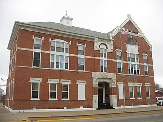
White County is a county located in the U.S. state of Illinois. According to the 2010 census, it had a population of 14,665. Its county seat is Carmi. It is located in the southern portion of Illinois known locally as "Little Egypt".
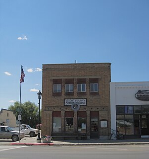
Camas County is a county in the southern portion of the U.S. state of Idaho. The county seat and largest city is Fairfield. The county was created 102 years ago in 1917 by the state legislature with a partition of Blaine County on February 6. It is named for the camas root, or Camassia, a lily-like plant with an edible bulb found in the region, that Native Americans and settlers used as a food source. As of the 2010 census, the population was 1,117, making it the second-least populous county in the state.

Prairie County is located in the Central Arkansas region of the U.S. state of Arkansas. The county is named for the Grand Prairie, a subregion of the Arkansas Delta known for rice cultivation and aquaculture which runs through the county. Created as Arkansas's 54th county in 1846, Prairie County is home to four incorporated towns, including DeValls Bluff, the southern district county seat, and two incorporated cities, including Des Arc, the northern district county seat. The county is also the site of numerous unincorporated communities and ghost towns. Occupying 676 square miles (175,000 ha), Prairie County is the median-sized county in Arkansas. As of the 2010 Census, the county's population is 8,715 people in 4,503 households. Based on population, the county is the ninth-smallest county of the 75 in Arkansas.
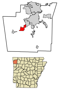
Prairie Grove is a city in Washington County, Arkansas, United States. The population was 4,380 at the 2010 Census. It is part of the Northwest Arkansas region, and home to Prairie Grove Battlefield State Park. The park spans a large amount of land and contains a visitor center, museum, several monuments, a driving tour and a collection of period buildings and homes.

Prairie City is a city within Jasper County, Iowa, United States. The population was 1,680 at the 2010 census. It is twenty-two miles east of Des Moines.

Prairie Village is a city in Johnson County, Kansas, United States, and part of the Kansas City Metropolitan Area. As of the 2010 census, the city population was 21,447.

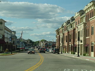
Eden Prairie is an edge city 12 miles (19 km) southwest of downtown Minneapolis in Hennepin County, and the 12th-largest city in the State of Minnesota. It is the 7th-largest suburb in the Twin Cities, with a population of 60,797 at the 2010 census. The city is on the north bank of the Minnesota River, upstream from its confluence with the Mississippi River.

Prairie Lake Township is a township in Saint Louis County, Minnesota, United States. The population was 50 at the 2010 census.

Prairie View is a city in Waller County, Texas, United States, situated on the northwestern edge of the Houston–The Woodlands–Sugar Land metropolitan area. The population was 5,576 at the 2010 census. The current estimated population is 6,197.

Grand Prairie is a city in Dallas County, Tarrant County, and Ellis County, Texas, in the United States. It is part of the Mid-Cities region in the Dallas–Fort Worth metroplex. It has a population of 175,396 according to the 2010 census, making it the fifteenth most populous city in the state.

Sun Prairie is a city in Dane County in the U.S. state of Wisconsin. A suburb of Madison, it is part of the Madison Metropolitan Statistical Area. The city's population was 29,441 at the 2010 U.S. Census. It is the second-most populous city in Dane County after Madison.
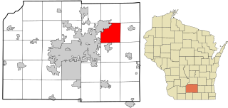
Sun Prairie is a town in Dane County, Wisconsin, United States. The population was 2,308 at the 2000 census. The City of Sun Prairie is located partially within the town. The unincorporated communities of Pierceville and Schey Acres are also located in the town.
Prairie du Sac is a village in Sauk County, Wisconsin, United States. The population was 3,972 at the 2010 census. The village is surrounded by the Town of Prairie du Sac, the Wisconsin River, and the village of Sauk City; together, Prairie du Sac and Sauk City are referred to as Sauk Prairie.

National Grassland is a classification of protected and managed federal lands in the United States authorized by Title III of the Bankhead–Jones Farm Tenant Act of 1937. For administrative purposes, they are essentially identical to United States National Forests, except that grasslands are areas primarily consisting of prairie. Like National Forests, National Grasslands may be open for hunting, grazing, mineral extraction, recreation and other uses. Various National Grasslands are typically administered in conjunction with nearby National Forests.

The Tallgrass prairie is an ecosystem native to central North America. Natural and anthropogenic fire, as well as grazing by large mammals, were historically agents of periodic disturbance, which regulates tree encroachment, recycles nutrients to the soil, and catalyzes some seed dispersal and germination processes. Prior to widespread use of the steel plow, which enabled conversion to agricultural land use, tallgrass prairies expanded throughout the American Midwest and smaller portions of southern central Canada, from the transitional ecotones out of eastern North American forests, west to a climatic threshold based on precipitation and soils, to the southern reaches of the Flint Hills in Oklahoma, to a transition into forest in Manitoba.

Attwater Prairie Chicken National Wildlife Refuge, is a federally protected refugium encompassing one of the largest remnants of coastal prairie habitat remaining in southeast Texas, United States and home to one of the last populations of the critically endangered Attwater's prairie chicken, a ground-dwelling grouse of the coastal prairie ecosystem.

Prairie School is a late 19th- and early 20th-century architectural style, most common to the Midwestern United States. The style is usually marked by horizontal lines, flat or hipped roofs with broad overhanging eaves, windows grouped in horizontal bands, integration with the landscape, solid construction, craftsmanship, and discipline in the use of ornament. Horizontal lines were thought to evoke and relate to the wide, flat, treeless expanses of America's native prairie landscape.

Frederick Vaughn "Fred" Newhouse is an American retired sprinter. He won a gold medal in the 4×400 meter relay and an individual silver in the 400 m, both at the 1971 Pan American Games and at the 1976 Olympics. His individual time of 44.40 seconds at the Olympics was the second fastest time of the 1970s.

The black-tailed prairie dog is a rodent of the family Sciuridae found in the Great Plains of North America from about the United States-Canada border to the United States-Mexico border. Unlike some other prairie dogs, these animals do not truly hibernate. The black-tailed prairie dog can be seen above ground in midwinter. A black-tailed prairie dog town in Texas was reported to cover 25,000 sq mi (64,000 km2) and included 400,000,000 individuals. Prior to habitat destruction, this species may have been the most abundant prairie dog in central North America. This species was one of two described by the Lewis and Clark Expedition in the journals and diaries of their expedition.


