Ruma, Illinois

Last updated

Ruma
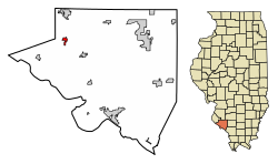
Randolph County Illinois Incorporated and Unincorporated areas Ruma Highlighted.svg
Location of Ruma in Randolph County, Illinois.
Illinois in United States (US48).svg
Location of Illinois in the United States
Coordinates: 38°8′1″N89°59′55″W / 38.13361°N 89.99861°W / 38.13361; -89.99861
CountryUnited States
StateIllinois
County Randolph
Area
[1]
  Total0.74 sq mi (1.92 km2)
  Land0.74 sq mi (1.92 km2)
  Water0.00 sq mi (0.00 km2)
Population
 (2020)
  Total313
  Density421.83/sq mi (162.90/km2)
Time zone UTC-6 (CST)
  Summer (DST) UTC-5 (CDT)
ZIP Code(s)
62278
Area code 618
FIPS code 17-66287
Wikimedia CommonsRuma, Illinois

Ruma is a village in Randolph County, Illinois, United States. The population was 317 at the 2010 census. [2]

Contents

Geography

Ruma is located at 38°8′1″N89°59′55″W / 38.13361°N 89.99861°W / 38.13361; -89.99861 (38.133512, -89.998497). [3]

According to the 2010 census, Ruma has a total area of 0.74 square miles (1.92 km2), all land. [4]

Demographics

Historical population
CensusPop.Note
1900 151
1910 138−8.6%
1920 100−27.5%
1930 79−21.0%
1940 9520.3%
1950 10712.6%
1960 13829.0%
1970 15411.6%
1980 25464.9%
1990 2560.8%
2000 2601.6%
2010 31721.9%
2020 313−1.3%
U.S. Decennial Census [5]

As of the census [6] of 2000, there were 260 people, 99 households, and 69 families residing in the village. The population density was 634.0 inhabitants per square mile (244.8/km2). There were 103 housing units at an average density of 251.2 per square mile (97.0/km2). The racial makeup of the village was 98.85% White and 1.15% Asian.

There were 99 households, out of which 40.4% had children under the age of 18 living with them, 59.6% were married couples living together, 6.1% had a female householder with no husband present, and 29.3% were non-families. 26.3% of all households were made up of individuals, and 11.1% had someone living alone who was 65 years of age or older. The average household size was 2.63 and the average family size was 3.20.

In the village, the population was spread out, with 31.5% under the age of 18, 8.1% from 18 to 24, 32.3% from 25 to 44, 18.1% from 45 to 64, and 10.0% who were 65 years of age or older. The median age was 33 years. For every 100 females, there were 103.1 males. For every 100 females age 18 and over, there were 100.0 males.

The median income for a household in the village was $33,929, and the median income for a family was $38,333. Males had a median income of $31,346 versus $21,250 for females. The per capita income for the village was $16,176. About 13.2% of families and 13.6% of the population were below the poverty line, including 20.0% of those under the age of eighteen and none of those 65 or over.

Related Research Articles

<span class="mw-page-title-main">Randolph County, Illinois</span> County in Illinois, United States

Randolph County is a county located in the U.S. state of Illinois. According to the 2020 census, it had a population of 30,163. Its county seat is Chester.

<span class="mw-page-title-main">Baldwin, Illinois</span> Village in Illinois, United States

Baldwin is a town in Randolph County, Illinois, United States. The population was 373 at the 2010 census. Baldwin Lake State Fish and Wildlife Area is nearby.

<span class="mw-page-title-main">Coulterville, Illinois</span> Village in Illinois, United States

Coulterville is a village in Randolph County, Illinois, United States. The population was 945 as of the 2010 census.

<span class="mw-page-title-main">Ellis Grove, Illinois</span> Village in Illinois, United States

Ellis Grove is a village in Randolph County, Illinois, United States. The population was 328 at the 2020 census.

<span class="mw-page-title-main">Evansville, Illinois</span> Village in Illinois, United States

Evansville is a village in Randolph County, Illinois, United States. The population was 701 at the 2010 census.

<span class="mw-page-title-main">Percy, Illinois</span> Village in Illinois, United States

Percy is a village in Randolph County, Illinois, United States. The population was 970 at the 2010 census.

<span class="mw-page-title-main">Red Bud, Illinois</span> City in Illinois, United States

Red Bud is a city in Randolph County, Illinois, in the United States. The population was 3,804 at the 2020 census.

<span class="mw-page-title-main">Rockwood, Illinois</span> Village in Illinois, United States

Rockwood is a village in Randolph County, Illinois, United States. The population was 42 at the 2010 census. It is the headquarters of the Middle Mississippi River National Wildlife Refuge.

<span class="mw-page-title-main">Tilden, Illinois</span> Village in Illinois, United States

Tilden is a village in Randolph County, Illinois, United States. The population was 934 at the 2010 census.

<span class="mw-page-title-main">Venedy, Illinois</span> Village in Illinois, United States

Venedy is a village in Washington County, Illinois, United States. The population was 138 at the 2010 census.

<span class="mw-page-title-main">Woodland, Michigan</span> Village in Michigan, United States

Woodland is a village in Barry County of the U.S. state of Michigan. The population was 425 at the 2010 census. The village is located within Woodland Township.

<span class="mw-page-title-main">Lauderdale, Minnesota</span> City in Minnesota, United States

Lauderdale is a city in Ramsey County, Minnesota, United States. The population was 2,379 at the 2010 census. Lauderdale is part of the Minneapolis–St. Paul metropolitan area and is surrounded by Minneapolis, St. Paul, Roseville, and Falcon Heights. Along with Roseville, it is one of two cities to touch both Minneapolis and St Paul.

<span class="mw-page-title-main">Ranlo, North Carolina</span> Town in North Carolina, United States

Ranlo is a small town in Gaston County, North Carolina, United States and a suburb of Charlotte, located north of Gastonia. As of the 2020 census, the town population was 4,511, up from 3,434 in 2010.

<span class="mw-page-title-main">Hollansburg, Ohio</span> Village in Ohio, United States

Hollansburg is a village in Darke County, Ohio, United States. The population was 243 at the 2020 census.

<span class="mw-page-title-main">Browntown, Wisconsin</span> Village in Wisconsin, United States

Browntown is a village in Green County, Wisconsin, United States. The population was 280 at the 2010 census.

Lynnwood-Pricedale is a census-designated place (CDP) in Fayette and Westmoreland counties in the commonwealth of Pennsylvania, United States. The population was 2,031 at the 2010 census, down from 2,168 at the 2000 census. The community of Lynwood is located in Fayette County's Washington Township, while Pricedale is part of Westmoreland County's Rostraver Township.

Randolph is a town in Cattaraugus County, New York, United States. The population was 2,470 at the 2020 census. The town was named after Randolph, Vermont.

Ellisburg is a village in Jefferson County, New York, United States. The population was 244 at the 2010 census. The village is named after two brothers who were the original landowners. It is located near the middle of the town of Ellisburg and is southwest of Watertown.

<span class="mw-page-title-main">Randolph, Wisconsin</span> Village in Wisconsin, United States

Randolph is a village in Columbia and Dodge Counties in the U.S. state of Wisconsin. The population was 1,811 at the 2010 census. Of this, 1,339 were in Dodge County, and 472 were in Columbia County. The village is located at the southeast corner of the Town of Randolph in Columbia County, although only a tiny portion of the village lies within the town. Most of the village lies within the Town of Westford in Dodge County. Small portions also lie within the Town of Fox Lake to the north and the Town of Courtland in Columbia County.

<span class="mw-page-title-main">Colfax, Wisconsin</span> Village in Wisconsin, United States

Colfax is a village in Dunn County, Wisconsin, United States. The population was 1,158 at the 2010 census. The village is surrounded by the Town of Colfax.

References

  1. "2020 U.S. Gazetteer Files". United States Census Bureau. Retrieved March 15, 2022.
  2. "Profile of General Population and Housing Characteristics: 2010 Demographic Profile Data (DP-1): Ruma village, Illinois". United States Census Bureau . Retrieved January 4, 2012.
  3. "US Gazetteer files: 2010, 2000, and 1990". United States Census Bureau. February 12, 2011. Retrieved April 23, 2011.
  4. "G001 - Geographic Identifiers - 2010 Census Summary File 1". United States Census Bureau. Archived from the original on February 13, 2020. Retrieved December 25, 2015.
  5. "Census of Population and Housing". Census.gov. Retrieved June 4, 2015.
  6. "U.S. Census website". United States Census Bureau . Retrieved January 31, 2008.