The city is home to Rock Island Arsenal, the largest government-owned weapons manufacturing arsenal in the United States, which employs 6,000 people.[5] The original Rock Island, from which the city name is derived, is now called Arsenal Island.[6]
History
The Harper House
The original portion of what is now known as Rock Island was called Farnhamsburg – after the original two homes were built by Colonel George Davenport and Russell Farnham in 1826. Davenport and Farnham were business partners, trading with the local Native Americans. The original city plat was filed on July 10, 1835, and was named Stephenson. It was renamed Rock Island in March 1841.[7]
The southern portion of Rock Island, including today's Watch Hill area, was originally known as Searstown. It was named after David B. Sears, who built the Sears Power Dam on the Rock River. Searstown was annexed by Rock Island in 1915.
The Chicago, Rock Island & Pacific Railroad (RI) was founded here in 1851, known informally as the Rock Island Line; over the next century, the railroad grew to serve fourteen states but ended in bankruptcy in 1980.[8] As part of later nineteenth-century development, two first-class hotels: the Harper House (built by Ben Harper and opened in February 1871) and the Rock Island House were built in town.[9] The Rock Island Arsenal has manufactured military equipment and ordnance for the U.S. Army since the 1880s.
Construction began in April 2017 for a new Rock Island County courthouse. The $28 million project was completed in the fall of 2018, and the old courthouse was expected to be torn down upon completion of the new building.[10] Resident opposition temporarily delayed the demolition, but the building was demolished in April 2023.[11]
Geography
According to the 2010 census, Rock Island has a total area of 17.872 square miles (46.29km2), of which 16.85 square miles (43.64km2) (or 94.28%) is land and 1.022 square miles (2.65km2) (5.72%) is water.[12]
Rock Island, Illinois – Racial and ethnic composition Note: the US Census treats Hispanic/Latino as an ethnic category. This table excludes Latinos from the racial categories and assigns them to a separate category. Hispanics/Latinos may be of any race.
In 2000 Census, there were 39,684 people, 16,148 households, and 9,543 families residing in the city.[19] The population density was 2,492.0 inhabitants per square mile (962.2/km2). There were 17,542 housing units at an average density of 1,101.6 per square mile (425.3/km2). The racial makeup of the city was 77.13% White, 17.17% African American, 0.28% Native American, 0.75% Asian, 0.07% Pacific Islander, 2.41% from other races, and 2.19% from two or more races. Hispanic or Latino of any race were 5.90% of the population.
There were 16,148 households, out of which 26.4% had children under the age of 18 living with them, 41.2% were married couples living together, 14.2% had a female householder with no husband present, and 40.9% were non-families. 34.5% of all households were made up of individuals, and 14.3% had someone living alone who was 65 years of age or older. The average household size was 2.31 and the average family size was 2.97.
The city's population was spread out, with 23.0% under the age of 18, 13.1% from 18 to 24, 25.7% from 25 to 44, 21.9% from 45 to 64, and 16.3% who were 65 years of age or older. The median age was 36 years. For every 100 females, there were 89.5 males. For every 100 females age 18 and over, there were 86.1 males.
The median income for a household in the city was $34,729, and the median income for a family was $45,127. Males had a median income of $32,815 versus $23,378 for females. The per capita income for the city was $19,202. About 10.9% of families and 14.5% of the population were below the poverty line, including 22.5% of those under age 18 and 8.4% of those age 65 or over.
The Denkmann-Hauberg House is a historic site in the city, which includes a community events space.[22]Bally's Quad Cities Casino & Hotel is located along the Mississippi River and is among the largest casinos in Illinois.[23]
The Black Hawk State Historic Site along the Rock River preserves the site of a 19th-century settlement and offers educational programs related to the area's indigenous and colonial history.[24] The Broadway Historic District is a designated neighborhood that features a collection of well-preserved late 19th- and early 20th-century buildings.[25]Chippiannock Cemetery was established in 1854 and is one of the oldest cemeteries in the area.[26]
Karters flock to Rock Island every year for the prestigious "Rock Island Grand Prix" on Labor Day weekend, which attracts competitors from across the United States and the world. With exception to 1997, when the annual race was canceled due to legal liability issues, the Rock Island Grand Prix has been held every year since 1994.[citation needed]
Rock Island is the location of television station WHBF-TV. Until 1963, WHBF was one of only two television stations in the Quad Cities area. (The other is WOC-TV on the Iowa side of the river.) Rock Island was also the longtime former home of WHBF-TV's former sister radio stations, WHBF and WHBF-FM, although it does remain the licensed city of those stations.
Rock Island is the home base for NOAA Weather RadioWXJ-73, the Quad Cities' area NWR station, programmed by the National Weather Service in Davenport.
Transportation
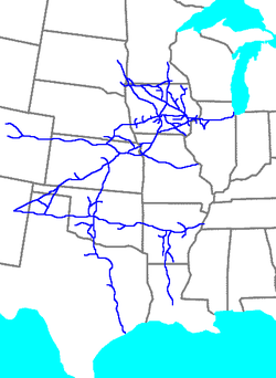
The Rock Island Line shipped goods from west of the Mississippi to Chicago. This map shows the railroad's extent in 1965.
Quad Cities MetroLINK provides bus service on numerous routes connecting Rock Island to destinations across the Quad Cities. District Station in downtown Rock Island serves as a hub of the system.[34]
The first railroad bridge across the Mississippi River was built between Arsenal Island and Davenport in 1856. Many steamboat pilots felt that the bridge had been intentionally positioned to make it hard for them to navigate, and this conflict reflected a larger rivalry: St. Louis-based steamboat transit against Chicago-based railroad transit.[35] Two weeks after the bridge opened, the steamboat Effie Afton collided with the bridge, caught fire, and damaged the bridge.[35] The owner of the Effie Afton sued the bridge company for damages, and the case, Hurd v. Rock Island Bridge Co., featured Abraham Lincoln as one of the lawyers who defended the railroad at trial in September 1857.[35][36] This test case was appealed to the United States Supreme Court, which ruled in favor of the railroad in 1862.[35] Although the original bridge is long gone, having been replaced in 1866 with a heavier bridge, a monument exists on Arsenal Island marking the Illinois side.[37] On the Iowa side, the bridge was located near where 4th and Federal streets intersect with River Drive.
On the south side of the city, overlooked by the Black Hawk State Historic Site, are auto and railroad crossings of the Rock River to Milan, Illinois. This set of bridges also crosses the historic Hennepin Canal and Sears Dam[38] (this was named after the entrepreneur David B. Sears, who previously built the Sears Dam between Arsenal Island and Moline.) In 2007 a new bridge was completed between 3rd Street Moline/southeast Rock Island and Milan.
Notable people
David Ackles, singer-songwriter, pianist, and child actor
Rock Island is mentioned several times in Jack Kerouac's book On the Road. Sal (Jack Kerouac) says that it was in Rock Island "for the first time in my life that I saw my beloved Mississippi River dry in the summer haze."[51]
↑Drury, George H. (1994). The Historical Guide to North American Railroads: Histories, Figures, and Features of more than 160 Railroads Abandoned or Merged since 1930. Waukesha, Wisconsin: Kalmbach Publishing. pp.87–93. ISBN0-89024-072-8.
↑"EVANS, Lane Allen, (1951 - )". Biographical Directory of the United States Congress. Archived from the original on October 19, 2012. Retrieved October 19, 2012.
↑'Illinois Blue Book 1993-1994,' Biographical Sketch of Virginia Feister Frederick, pg. 95
↑'Illinois Blue Book 167-168,' Biographical Sketch of Paul E. Rink, pg. 278-279
↑"SCHILLING, Bobby, (1964 - )". Biographical Directory of the United States Congress. Archived from the original on October 19, 2012. Retrieved October 19, 2012.
↑'Illinois Blue Book 1951-1952,' Biographical Sketch of Clinton Searle, pg. 212-213
This page is based on this Wikipedia article Text is available under the CC BY-SA 4.0 license; additional terms may apply. Images, videos and audio are available under their respective licenses.