Barstow, Illinois

Last updated

Barstow, Illinois
Barstow.jpg
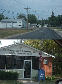
Barstow Fire Station and Post Office
USA Illinois location map.svg
Red pog.svg
Barstow, Illinois
Usa edcp location map.svg
Red pog.svg
Barstow, Illinois
Coordinates: 41°31′06″N90°21′25″W / 41.51833°N 90.35694°W / 41.51833; -90.35694
Country United States
State Illinois
County Rock Island
Area
[1]
  Total
0.11 sq mi (0.28 km2)
  Land0.11 sq mi (0.28 km2)
  Water0.00 sq mi (0.00 km2)
Elevation
574 ft (175 m)
Population
 (2020)
  Total
89
  Density839.62/sq mi (323.61/km2)
Time zone UTC-6 (Central (CST))
  Summer (DST) UTC-5 (CDT)
Area code 309
FIPS code 17-03987
GNIS feature ID403936 [2]

Barstow is an unincorporated community in Rock Island County, Illinois, United States. Barstow is east of East Moline and Silvis. Barstow is located on a wye that connects track owned by the BNSF Railway, including the Barstow Subdivision. [3] These tracks were previously owned by the Chicago, Burlington and Quincy Railroad (CB&Q), and a station once existed within the wye.

Contents

Barstow was to be the site of a planned hog plant and a Nascar race track, but both plans were shelved after heavy opposition to them[ when? ][ citation needed ].

Demographics

Historical population
CensusPop.Note
2020 89
U.S. Decennial Census [4]

Barstow first appeared as a census designated place in the 2020 U.S. Census. [5]

2020 census

Barstow CDP, Illinois – Racial and ethnic composition
Note: the US Census treats Hispanic/Latino as an ethnic category. This table excludes Latinos from the racial categories and assigns them to a separate category. Hispanics/Latinos may be of any race.
Race / Ethnicity (NH = Non-Hispanic)Pop 2020 [6] % 2020
White alone (NH)8393.26%
Black or African American alone (NH)00.00%
Native American or Alaska Native alone (NH)00.00%
Asian alone (NH)00.00%
Native Hawaiian or Pacific Islander alone (NH)00.00%
Other race alone (NH)11.12%
Mixed race or Multiracial (NH)11.12%
Hispanic or Latino (any race)44.49%
Total89 100.00%

References

  1. "2020 U.S. Gazetteer Files". United States Census Bureau. Retrieved March 15, 2022.
  2. "Barstow". Geographic Names Information System . United States Geological Survey, United States Department of the Interior.
  3. BNSF Subdivision Map (PDF) (Map). BNSF Railway. September 1, 2011. Retrieved April 5, 2020.
  4. "Census of Population and Housing". Census.gov. Retrieved June 4, 2016.
  5. "2020 Geography Changes". United States Census Bureau.
  6. "P2: Hispanic or Latino, and Not Hispanic or Latino by Race – 2020: DEC Redistricting Data (PL 94-171) – Barstow CDP, Illinois". United States Census Bureau .
Preceding station Burlington Route Following station
Colona
toward St. Louis
St. LouisSavanna East Moline
toward Savanna
Terminus Barstow  Earlville Joslin
toward Earlville