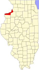
Blackhawk Township is located in Rock Island County, Illinois. As of the 2010 census, its population was 10,019 and it contained 4,563 housing units. Blackhawk Township changed its name from Camden County on October 1, 1857.

Bowling Township is located in Rock Island County, Illinois. As of the 2010 census, its population was 3,414 and it contained 1,455 housing units.

Buffalo Prairie Township is located in Rock Island County, Illinois. As of the 2010 census, its population was 824 and it contained 359 housing units. Buffalo Prairie Township was originally named Buffalo Township, but changed its name to Copper Township October 1, 1857, and then from Copper to Buffalo Prairie.

Canoe Creek Township is located in Rock Island County, Illinois. As of the 2010 census, its population was 711 and it contained 317 housing units.

Coal Valley Township is located in Rock Island County, Illinois. As of the 2010 census, its population was 4,408 and it contained 1,910 housing units.
Coe Township is located in Rock Island County, Illinois. As of the 2010 census, its population was 1,657 and it contained 659 housing units. Coe Township originally was named Fremont Township, but changed its name to Penn Township on October 1, 1857. Then changed its name from Penn to Coe in January, 1858.

Drury Township is located in Rock Island County, Illinois. As of the 2010 census, its population was 797 and it contained 328 housing units.

Edgington Township is located in Rock Island County, Illinois. As of the 2010 census, its population was 1,508 and it contained 643 housing units.

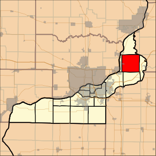
Hampton Township is located in Rock Island County, Illinois. As of the 2010 census, its population was 21,711 and it contained 9,119 housing units.

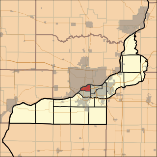
Moline Township is located in Rock Island County, Illinois, USA. At the 2010 census, its population was 23,529 and it contained 10,314 housing units.

Port Byron Township is located in Rock Island County, Illinois. As of the 2010 census, its population was 1,446 and it contained 704 housing units. Located on the Mississippi river. The major business is Sandstrum Industries with John Deere 15 minutes down state Hy 84 to the south. The John Deere corporate headquarters is in Moline 20 minutes south. Locally Port Byron has six bars and restaurants from fine dining to burgers and chili. Located 2 miles north of the Interstate 80 bridge over the Mississippi River on Illinois route 84, Port Byron is also on the Mississippi River Flyway for migrating birds. Thousands of species can be seen as they travel from Canada to the Gulf Coast espiecally the Pelicans in summer and the Eagles in winter.
Rock Island Township is located in Rock Island County, Illinois. As of the 2010 census, its population was 17,776 and it contained 7,271 housing units.

Rural Township is located in Rock Island County, Illinois. As of the 2010 census, its population was 988 and it contained 389 housing units. The township, located south of Moline, Illinois, was formed from Coal Valley Township prior to 1839.

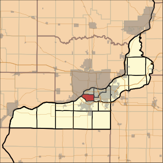
South Moline Township is located in Rock Island County, Illinois. As of the 2010 census, its population was 36,399 and it contained 17,140 housing units. South Moline Township formed from Moline Township in March, 1879.
South Rock Island Township is located in Rock Island County, Illinois. As of the 2010 census, its population was 18,407 and it contained 8,951 housing units. South Rock Island Township formed from Rock Island Township on March 1, 1878.

Colona Township is one of twenty-four townships in Henry County, Illinois, USA. As of the 2010 census, its population was 6,822 and it contained 2,773 housing units. Colona Township changed its name from Green River Township on April 13, 1857.

Hanna Township is one of twenty-four townships in Henry County, Illinois, USA. As of the 2010 census, its population was 2,344 and it contained 923 housing units.

Lynn Township is one of twenty-four townships in Henry County, Illinois, USA. As of the 2010 census, its population was 745 and it contained 311 housing units. Lynn changed its name originally from Linn Grove Township to Lynnville Township on April 13, 1857, and then again from Lynnville to Lynn on an unknown date.

Phenix Township is one of twenty-four townships in Henry County, Illinois, USA. As of the 2010 census, its population was 1,672 and it contained 654 housing units.

Western Township is one of twenty-four townships in Henry County, Illinois, USA. As of the 2010 census, its population was 3,053 and it contained 1,240 housing units. Western changed its name from Orion Township on April 13, 1857.