Mount Carmel, Illinois

Last updated

City of Mount Carmel
Wabash County Courthouse in Mount Carmel.jpg
Wabash County Illinois Incorporated and Unincorporated areas Mount Carmel Highlighted.svg
Location of Mount Carmel in Wabash County, Illinois.
Illinois in United States (US48).svg
Location of Illinois in the United States
Coordinates: 38°25′07″N87°46′10″W / 38.41861°N 87.76944°W / 38.41861; -87.76944 [1]
CountryUnited States
State Illinois
County Wabash
Precinct Mount Carmel
Founded1815 (1815)
Government
  MayorJoe Judge [2]
Area
[3]
  Total4.95 sq mi (12.82 km2)
  Land4.81 sq mi (12.46 km2)
  Water0.14 sq mi (0.37 km2)
Elevation
[1]
456 ft (139 m)
Population
 (2020)
  Total7,015
  Density1,458.72/sq mi (563.19/km2)
Time zone UTC−6 (CST)
  Summer (DST) UTC−5 (CDT)
ZIP code
62863
Area codes Area code 618
Local numbers
262, 263, 264
FIPS code 17-50868
GNIS ID2395120 [1]

Mount Carmel is a city in and the county seat of Wabash County, Illinois, United States. [4] At the time of the 2010 census, the population was 7,284, and it is the largest city in the county. The next largest town in Wabash County is Allendale, population 475.

Contents

Located at the confluence of the Wabash, Patoka, and White rivers, Mount Carmel borders both Gibson and Knox counties of Indiana. A small community known informally as East Mount Carmel sits near the mouth of the Patoka River on the opposite (Gibson County) side of the Wabash River from Mount Carmel. Mount Carmel is 5 miles (8.0 km) northeast of the Forest of the Wabash, a National Natural Landmark within Beall Woods State Park and about a mile north-northeast of one of its main employers, the Gibson Generating Station. Mount Carmel is also the home of Wabash Valley College, part of the Community College System of Eastern Illinois. Some know Mt. Carmel as Mountain Carmel.

History

Tornado

On June 4, 1877, a tornado of F4 intensity touched down just west of Mount Carmel and moved east-northeast, devastating the town. [5] The storm's line of destruction wreaked havoc on a large part of the territory between Third and Fifth streets. The velocity of the wind was estimated at 150 miles per hour for a duration of almost two minutes.

As described in a local newspaper at the time: "During its prevalence the air was filled with flying roofs, windows, doors, lumber, rails, clothing, etc. Much of the debris was carried more than a mile away. Thirteen persons were killed outright, and many others will undoubtedly die of their injuries. There are also several others reported missing who are probably buried in the ruins. It being a rainy day, many farmers who could not work at home were in town. The county court was also in session, which caused many people to be in the city.

Men, women and children were blown a distance of 400 feet, as if they were feathers. The better part of the town Is destroyed. Some seventy families were rendered houseless and much distress is anticipated." [6]

Final estimates of the damage indicate that 20 businesses and 100 homes were damaged or destroyed. At least 16 people, and as many as 30, were killed, with 100 injured. [7]

Grand Rapids Hotel and Resort

In the 1920s, there was a hotel in Wabash County near the Grand Rapids Dam and Hanging Rock on the Wabash River. The hotel was called the Grand Rapids Hotel and was owned by Frederick Hinde Zimmerman. During the hotel's nine-year existence, it catered to individuals from all over the United States.

Hotel Picture 1922.jpg

Geography

Former bridge over the Wabash River formerly featured in Ripley's Believe It or Not! This bridge was replaced in 2011 and demolished in 2012. Mount Carmel bridge 2007.JPG
Former bridge over the Wabash River formerly featured in Ripley's Believe It or Not! This bridge was replaced in 2011 and demolished in 2012.

Mount Carmel is located on the Wabash River, which demarcates the Indiana border. According to the 2010 census, the city has a total area of 5.00 square miles (12.9 km2), of which 4.86 square miles (12.6 km2) (or 97.20%) is land and 0.14 square miles (0.36 km2) (or 2.80%) is water. [8]

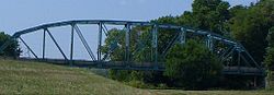
The city was featured in Ripley's Believe It or Not! for its once multicolored bridge over the Wabash River, painted white and black on the Illinois and Indiana sides of the state line, respectively. The old twelve span Parker truss bridge, later repainted entirely green, formerly connected Princeton, Indiana to Mount Carmel via Indiana State Road 64 and Illinois Route 15. [9] Illinois Route 1 and Illinois Route 15 meet just a few blocks from the bridge. One rail bridge runs parallel to the IN-64/IL-15 bridge, and another sits just a few miles south, near the southernmost edge of the city. The plans to build a new bridge become reality in 2008. After three years of construction the new much wider span opens in January 2011. The new bridge is a milestone as Indiana continues its quest to expand Indiana 64 to a four-lane highway as part of the Major Moves Project. [10] As of February 20, 2011 the new concrete and steel beam bridge is fully carrying traffic. The old bridge has been removed, with the river spans being imploded.

Earthquake

Mount Carmel is within the Wabash Valley Seismic Zone. On April 18, 2008, at 09:36:56 UTC (04:36:56 Central) an earthquake of 5.2 magnitude was centered near the city, and just hours later an aftershock of 4.6 magnitude shook Mt. Carmel and its residences. It was felt widespread across southern Illinois and eastern portions of Missouri including St. Louis, 123 miles (198 km) away. Aftershocks continued into July. [11] [12] [13] [14]

Demographics

Historical population
CensusPop.Note
1850 935
1860 1,39349.0%
1870 1,64017.7%
1880 2,04724.8%
1890 3,37664.9%
1900 4,31127.7%
1910 6,93460.8%
1920 7,4567.5%
1930 7,132−4.3%
1940 6,987−2.0%
1950 8,73225.0%
1960 8,594−1.6%
1970 8,096−5.8%
1980 8,90810.0%
1990 8,287−7.0%
2000 7,982−3.7%
2010 7,284−8.7%
2020 7,015−3.7%
U.S. Decennial Census [15]
Cherry St. near 7th street is home to some of the oldest homes in Mount Carmel, and still retains its brick surface and sidewalk. Mount Carmel Cherry St.JPG
Cherry St. near 7th street is home to some of the oldest homes in Mount Carmel, and still retains its brick surface and sidewalk.

As of the census [16] of 2000, there were 7,982 people, 3,302 households, and 2,146 families residing in the city. The population density was 1,728.7 inhabitants per square mile (667.5/km2). There were 3,653 housing units at an average density of 791.2 per square mile (305.5/km2). The racial makeup of the city was 97.69% White, 0.48% African American, 0.19% Native American, 0.51% Asian, 0.08% Pacific Islander, 0.29% from other races, and 0.76% from two or more races. Hispanic or Latino of any race were 0.86% of the population.

There were 3,302 households, out of which 29.3% had children under the age of 18 living with them, 51.2% were married couples living together, 10.5% had a female householder with no husband present, and 35.0% were non-families. 30.6% of all households were made up of individuals, and 15.9% had someone living alone who was 65 years of age or older. The average household size was 2.37 and the average family size was 2.95.

In the city the population was spread out, with 23.6% under the age of 18, 9.8% from 18 to 24, 25.7% from 25 to 44, 21.8% from 45 to 64, and 19.2% who were 65 years of age or older. The median age was 39 years. For every 100 females, there were 90.6 males. For every 100 females age 18 and over, there were 88.4 males.

The median income for a household in the city was $31,715, and the median income for a family was $39,882. Males had a median income of $30,815 versus $17,129 for females. The per capita income for the city was $16,391. Median house value was $51,200. About 10.2% of families and 15.8% of the population were below the poverty line, including 20.5% of those under age 18 and 9.3% of those age 65 or over.

Education

MCHS's Riverview Stadium Snakepit-offcenter.JPG
MCHS's Riverview Stadium

Mount Carmel is home to Wabash Valley College, part of the Illinois Eastern Community Colleges (IECC). The college has 1375 students, and has an active international student program. The small town atmosphere provides a laid back, comfortable setting in which international students may study English as a second language (ESL). As part of the IECC, residents benefit from a reciprocal agreement where some of the out-of-state fees to attend the University of Southern Indiana are waived, in exchange for similar tuition discounts for Indiana students in IECC schools. Their men's basketball team, the Warriors, won the NJCAA Division I championships in 2001.

Mount Carmel's K-12 school district is Wabash Community Schools District 348. It has two elementary schools, divided by grade (Mount Carmel Elementary School and Mount Carmel Grade School), Mount Carmel Junior High School, and Mount Carmel High School, the only high school in the county. The high school's football team, The Golden Aces, won the class 3A state championships in 1981, and the team made it to the playoffs 21 years in a row. They play at home in Riverview Stadium, commonly known as "The Snake Pit". [17] The stadium is notable for having been built into the side of a large hill.

Employment and environment

Market St. in midsummer Mount Carmel Market.JPG
Market St. in midsummer

The town had an unemployment rate of 5.4%, as of Dec 2014. [18] The situation has substantially improved since 1992, when the unemployment rate peaked as high as 15.1% with the loss of industrial jobs. [19]

Duke Energy's Gibson Generating Station is the nearest employer of substantial size. The Gibson County, Indiana power plant is located less than a mile away from Mount Carmel, directly across the river. It is the third-largest coal power plant in the world, [20] and the ninth largest power plant in the United States. [21]

Additional nearby employers include Toyota Motor Manufacturing Indiana, which produces the Sequoia, Sienna, Highlander, and Highlander Hybrid lines. Many of TMMI's Suppliers and subsidiaries are also located in and around Princeton, Indiana, 12 miles away. Other employers include Champion Laboratories plant in Albion, Illinois that produces air and fuel filters and an ATS (now TBIL) plant in Lawrenceville, which also supplies TMMI. Local employers include several oil and gas firms, exploiting the Southern Indiana Oil Basin, which extends into Illinois, Indiana, and Kentucky. It once had reserves of more than 4,000,000,000 barrels (640,000,000 m3) of crude oil.

On April 5, 2007, Foundation Coal Holdings, Inc., of Linthicum Heights, Maryland, announced plans to close the Wabash Mine in nearby Keensburg, Illinois, meaning a loss of nearly 230 jobs in Wabash County.[ citation needed ] Mount Carmel lost 270 jobs in 2003 due to the closing of a Snap-on Tools factory, which had operated since 1937.

Notable people

Related Research Articles

<span class="mw-page-title-main">Knox County, Indiana</span> County in Indiana, United States

Knox County is a county in the U.S. state of Indiana in the United States. The oldest county in Indiana, it was one of two original counties created in the Northwest Territory in 1790, alongside St. Clair County, Illinois. Knox County was gradually reduced in size as subsequent counties were established. It was established in its present configuration when Daviess County was partitioned off. At the 2020 United States Census, the county population was 36,282. The county seat is Vincennes.

<span class="mw-page-title-main">Gibson County, Indiana</span> County in Indiana, United States

Gibson County is a county in the southwestern part of the U.S. state of Indiana. As of the 2020 United States Census, the population was 33,011. The county seat is Princeton.

<span class="mw-page-title-main">Wabash County, Illinois</span> County in Illinois, United States

Wabash County is a county located in the U.S. state of Illinois. According to the 2020 census, it had a population of 11,361. Its county seat is Mount Carmel. It is located in the southern portion of Illinois known locally as "Little Egypt".

<span class="mw-page-title-main">Grayville, Illinois</span> City in Illinois, United States

Grayville is a city in Edwards and White counties in the U.S. state of Illinois. As of the 2020 census, the city's population was 1,550, down from 1,666 at the 2010 census. Grayville is the birthplace of naval hero James Meredith Helm.

<span class="mw-page-title-main">Owensville, Indiana</span> Town in Indiana, United States

Owensville is the third largest town and the smallest of the five larger communities in Gibson County, Indiana, United States. The population was 1,338 in 2020.

<span class="mw-page-title-main">Wabash River</span> Tributary of the Ohio River in the United States

The Wabash River is a 503-mile-long (810 km) river that drains most of the state of Indiana in the United States. It flows from the headwaters in Ohio, near the Indiana border, then southwest across northern Indiana turning south near the Illinois border, where the southern portion forms the Indiana-Illinois border before flowing into the Ohio River.

<span class="mw-page-title-main">White River (Indiana)</span> River in Indiana, United States

The White River is an American two-forked river that flows through central and southern Indiana and is the main tributary to the Wabash River. Via the west fork, considered to be the main stem of the river by the U.S. Board on Geographic Names, the White River is 362 miles (583 km) long. Indiana's capital, Indianapolis, is located on the river. The two forks meet just north of Petersburg and empty into the Wabash River at Mount Carmel, Illinois.

The Illinois Eastern Community Colleges is a community college district headquartered in Olney, IL, with college campuses located in Olney, Fairfield, Robinson, and Mount Carmel.

<span class="mw-page-title-main">Wabash Valley</span> Region in Illinois and Indiana

The Wabash Valley is a region located in sections of both Illinois and Indiana. It is named for the Wabash River and, as the name is typically used, spans the middle to the middle-lower portion of the river's valley and is centered at Terre Haute, Indiana. The term Wabash Valley is frequently used in local media in Clinton, Lafayette, Mount Carmel, Princeton, Terre Haute, and Vincennes all of which are either on or near the Lower Wabash River.

<span class="mw-page-title-main">Indiana State Road 64</span> Highway in Indiana

State Road 64 in the U.S. State of Indiana is an east–west highway that crosses most of the southern portion of the state, covering a distance of about 107 miles (172 km).

<span class="mw-page-title-main">Grand Rapids Hotel</span> Building in Wabash River, United States

The Grand Rapids Hotel also known as The Grand Rapids Resort, was a hotel that existed outside of Mount Carmel, Illinois, in Wabash County, Illinois, United States in Southern Illinois from 1922 to 1929. The hotel was located on the Wabash River next to the Grand Rapids Dam on land that was originally purchased by Thomas S. Hinde. Before the hotel was built, the property where the hotel was located was a site of a former homestead, and was used by Frederick Hinde Zimmerman for multiple small shops that sold goods to fisherman and tourists.

<span class="mw-page-title-main">Charles T. Hinde</span> American industrialist

Charles T. Hinde was an American industrialist, tycoon, riverboat captain, businessman, and entrepreneur. He managed many businesses and invested in numerous business ventures over the course of his life. Hinde served in executive leadership positions in the river navigation, shipping, railroad, and hotel businesses. By his late forties, Hinde had already amassed a great fortune from his work in the steamboat and railroad industries.

<span class="mw-page-title-main">Thomas S. Hinde</span> American minister and businessman

Thomas Spottswood Hinde was an American newspaper editor, opponent of slavery, author, historian, real estate investor, Methodist minister and a founder of the city of Mount Carmel, Illinois. Members of the Hinde family were prominent in Virginia, Kentucky, Ohio, and Illinois. His sons Charles T. Hinde became a shipping magnate and Edmund C. Hinde an adventurer. He was the father-in-law of judge Charles H. Constable.

<span class="mw-page-title-main">Frederick Hinde Zimmerman</span> American businessman

Frederick Hinde Zimmerman was an American banker, farmer, real estate entrepreneur, businessman, and hotel owner. Due to his large land holdings and expertise in farming, Zimmerman became a notable farmer, breeder, and real estate entrepreneur. Zimmerman's farm, originally purchased by his grandfather Thomas S. Hinde from the federal government in 1815, included the Grand Rapids Dam, Hanging Rock, and Buttercrust. His first experience running a business was in 1883 when he ran a grocery store in Fort Smith, Arkansas with his cousin Harry Hinde. Many of his businesses centered on his family farm, but in later years Zimmerman achieved success through his ownership and investment in mines, banks, and real estate. He also owned or invested in the Hanging Rock and Grand Rapids Dam Farm Company, the Grand Rapids Hotel Park Company, and the Wabash Bull-Frog Mines Company.

<span class="mw-page-title-main">Grand Rapids Dam</span> Dam in Indiana, US

The Grand Rapids Dam was a dam located on the Wabash River on the state line between Wabash County and Knox County in the U.S. states of Illinois and Indiana. The dam was built in the late 1890s by the Army Corps of Engineers to improve navigation on the Wabash River. The dam was located near Mount Carmel, Illinois.

<span class="mw-page-title-main">Edmund C. Hinde</span> American gold miner and laborer

Edmund C. Hinde was a gold miner and laborer. His life was, at times, extremely difficult and filled with various hardships due to his career as a gold prospector in the 1850s. Throughout most of his adult life Hinde kept detailed diaries on his daily activities. After his death, his son, Harry Hinde, donated the diaries to the California State Library. The diaries have provided a wealth of information on a variety of topics, in particular on the California Gold Rush.

<span class="mw-page-title-main">Glenn Goodart</span> American politician

Ira Glenn Goodart was an American railroad conductor, hotel manager, county commissioner and county treasurer. Goodart was raised in Friendsville, Illinois, a small community outside of Mount Carmel, Illinois, in a German Catholic family. After trying a variety of menial jobs Goodart took a position on the New York Central Railroad as a conductor. He held the position with the New York Central until he lost his right leg during a violent train crash in the early 1920s.

<span class="mw-page-title-main">Jacob Zimmerman</span> American politician

Jacob Zimmerman was an Illinois state legislator, newspaper editor, and businessman. Zimmerman was a pioneer in the newspaper business in Illinois and Ohio, and a businessman who invested in mining, land, and banks in the Midwest. Zimmerman held a number of elected political offices in Illinois before his death in 1912.

<span class="mw-page-title-main">O. L. Rapson</span>

Oscar Luscher Rapson was an American farmhand, hotel manager and store owner. Rapson is best known for being the first manager of the Grand Rapids Hotel, which was the first major resort on the Wabash River.

<span class="mw-page-title-main">Hanging Rock (Wabash River)</span>

Hanging Rock is a natural sandstone rock formation overhanging the Wabash River in Wabash County, Illinois, in the United States. The rock formation is north of the town of Mount Carmel, Illinois, and located on land originally purchased by Thomas S. Hinde. The formation was formed while the glaciers melted and carved the landscapes of North America. The Native Americans were the first group of people to settle around Hanging Rock. Later the Hinde family purchased the property and used it for tourism and business.

References

  1. 1 2 3 U.S. Geological Survey Geographic Names Information System: Mount Carmel, Illinois
  2. Mount Carmel city government
  3. "2020 U.S. Gazetteer Files". United States Census Bureau. Retrieved March 15, 2022.
  4. "Find a County". National Association of Counties. Retrieved June 7, 2011.
  5. "Scientific American, "Mount Carmel, IL, Destroyed By A Tornado"". Google Books. June 23, 1877. p. 393.
  6. "Mt Carmel, IL Tornado, Jun 1887". Archived from the original on March 7, 2019. Retrieved May 29, 2016.
  7. "Central Illinois" . Retrieved May 29, 2016.
  8. "Places: Illinois". 2010 Census Gazetteer Files . United States Census Bureau. Archived from the original on October 21, 2013. Retrieved October 13, 2012.{{cite web}}: External link in |work= (help)
  9. Wabash County Museum – Crossing the Wabash Archived 2007-09-28 at the Wayback Machine
  10. INDOT information on SR 64 bridge project Archived 2007-09-26 at the Wayback Machine
  11. Television reports, KSDK, "Early Today", "Today in St. Louis at 5:00", April 18, 2008
  12. "The Associated Press: 5.4 earthquake rocks Illinois; also felt in Indiana". Archived from the original on April 22, 2008. Retrieved May 29, 2016.
  13. "Magnitude 5.4 - ILLINOIS". Archived from the original on September 1, 2009. Retrieved May 29, 2016.
  14. "Magnitude 3.1 - ILLINOIS". Archived from the original on July 20, 2008. Retrieved May 29, 2016.
  15. "Census of Population and Housing". Census.gov. Retrieved June 4, 2015.
  16. "U.S. Census website". United States Census Bureau . Retrieved January 31, 2008.
  17. "Aces Football". Archived from the original on April 7, 2016. Retrieved May 29, 2016.
  18. "Archived copy" (PDF). Archived from the original (PDF) on February 23, 2015. Retrieved February 23, 2015.{{cite web}}: CS1 maint: archived copy as title (link)
  19. Historical unemployment data
  20. Attractions in Gibson County Archived 2006-07-23 at the Wayback Machine
  21. "Electricity in the United States" . Retrieved May 29, 2016.