
The Mississippi River is the second-longest river and chief river of the second-largest drainage system in North America, second only to the Hudson Bay drainage system. From its traditional source of Lake Itasca in northern Minnesota, it flows generally south for 2,340 miles (3,770 km) to the Mississippi River Delta in the Gulf of Mexico. With its many tributaries, the Mississippi's watershed drains all or parts of 32 U.S. states and two Canadian provinces between the Rocky and Appalachian mountains. The main stem is entirely within the United States; the total drainage basin is 1,151,000 sq mi (2,980,000 km2), of which only about one percent is in Canada. The Mississippi ranks as the thirteenth-largest river by discharge in the world. The river either borders or passes through the states of Minnesota, Wisconsin, Iowa, Illinois, Missouri, Kentucky, Tennessee, Arkansas, Mississippi, and Louisiana.

The Ohio River is a 981-mile (1,579 km) long river in the United States. It is located at the boundary of the Midwestern and Southern United States, flowing southwesterly from western Pennsylvania to its mouth on the Mississippi River at the southern tip of Illinois. It is the third largest river by discharge volume in the United States and the largest tributary by volume of the north-south flowing Mississippi River that divides the eastern from western United States. It is also the 6th oldest river on the North American continent. The river flows through or along the border of six states, and its drainage basin includes parts of 14 states. Through its largest tributary, the Tennessee River, the basin includes several states of the southeastern U.S. It is the source of drinking water for five million people.

Wabash County is a county located in the U.S. state of Illinois. According to the 2010 census, it had a population of 11,947. Its county seat is Mount Carmel. It is located in the southern portion of Illinois known locally as "Little Egypt".
Mount Carmel is a city in and the county seat of Wabash County, Illinois, United States. At the time of the 2010 census, the population was 7,284, and it is the largest city in the county. The next largest town in Wabash County is Allendale, population 475.

The Wabash River is a 503-mile-long (810 km) river that drains most of the state of Indiana in the United States. It flows from the headwaters in Ohio, near the Indiana border, then southwest across northern Indiana turning south near the Illinois border, where the southern portion forms the Indiana-Illinois border before flowing into the Ohio River.

The White River is an American two-forked river that flows through central and southern Indiana and is the main tributary to the Wabash River. Via the west fork, considered to be the main stem of the river by the U.S. Board on Geographic Names, the White River is 362 miles (583 km) long. Indiana's capital, Indianapolis, is located on the river. The two forks meet just north of Petersburg and empty into the Wabash River at Mount Carmel, Illinois.

The Falls of the Ohio National Wildlife Conservation Area is a national, bi-state area on the Ohio River near Louisville, Kentucky in the United States, administered by the U.S. Army Corps of Engineers. Federal status was awarded in 1981. The falls were designated a National Natural Landmark in 1966.

The McAlpine Locks and Dam are a set of locks and a hydroelectric dam at the Falls of the Ohio River at Louisville, Kentucky. They are located at mile point 606.8, and control a 72.9 miles (117.3 km) long navigation pool. The locks and their associated canal were the first major engineering project on the Ohio River, completed in 1830 as the Louisville and Portland Canal, designed to allow shipping traffic to navigate through the Falls of the Ohio.

The Markland Locks and Dam is a concrete dam bridge and locks that span the Ohio River. It is 1395 feet long, and connects Gallatin County, Kentucky, and Switzerland County, Indiana.

Kentucky Dam is a hydroelectric dam on the Tennessee River on the county line between Livingston and Marshall counties in the U.S. state of Kentucky. The dam is the lowermost of nine dams on the river owned and operated by the Tennessee Valley Authority, which built the dam in the late 1930s and early 1940s to improve navigation on the lower part of the river and reduce flooding on the lower Ohio and Mississippi rivers. It was a major project initiated during the New Deal of President Franklin D. Roosevelt's administration, to invest in infrastructure to benefit the country. The dam impounds the Kentucky Lake of 160,000 acres (65,000 ha), which is the largest of TVA's reservoirs and the largest artificial lake by area in the Eastern United States. It was designated as an National Historic Civil Engineering Landmark by the American Society of Civil Engineers in 1996 and listed on the National Register of Historic Places in 2017.
The Louisville and Portland Canal was a 2-mile (3.2 km) canal bypassing the Falls of the Ohio River at Louisville, Kentucky. The Falls form the only barrier to navigation between the origin of the Ohio at Pittsburgh and the port of New Orleans on the Gulf of Mexico; circumventing them was long a goal for Pennsylvanian and Cincinnatian merchants. The canal opened in 1830 as the private Louisville and Portland Canal Company but was gradually bought out during the 19th century by the federal government, which had invested heavily in its construction, maintenance, and improvement.
Rivers and Harbors Act may refer to one of many pieces of legislation and appropriations passed by the United States Congress since the first such legislation in 1824. At that time Congress appropriated $75,000 to improve navigation on the Ohio and Mississippi rivers by removing sandbars, snags, and other obstacles. Like when first passed, the legislation was to be administered by the United States Army Corps of Engineers (USACE), under its Chief Engineer and the Secretary of War.

The Grand Rapids Hotel also known as The Grand Rapids Resort, was a hotel that existed outside of Mount Carmel, Illinois, in Wabash County, Illinois, United States in Southern Illinois from 1922 to 1929. The hotel was located on the Wabash River next to the Grand Rapids Dam on land that was originally purchased by Thomas S. Hinde. Before the hotel was built, the property where the hotel was located was a site of a former homestead, and was used by Frederick Hinde Zimmerman for multiple small shops that sold goods to fisherman and tourists.
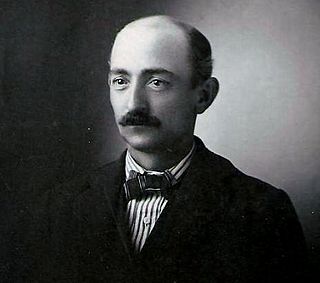
Charles T. Hinde was an American industrialist, tycoon, riverboat captain, businessman, and entrepreneur. He managed many businesses and invested in numerous business ventures over the course of his life. Hinde served in executive leadership positions in the river navigation, shipping, railroad, and hotel businesses. By his late forties, Hinde had already amassed a great fortune from his work in the steamboat and railroad industries.

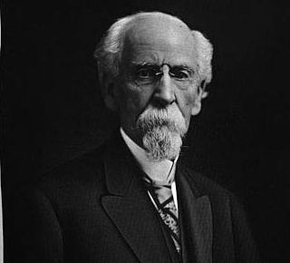
Thomas Spottswood Hinde was an American newspaper editor, opponent of slavery, author, historian, real estate investor, Methodist minister and a founder of the city of Mount Carmel, Illinois. Members of the Hinde family were prominent in Virginia, Kentucky, Ohio, and Illinois. His sons Charles T. Hinde became a shipping magnate and Edmund C. Hinde an adventurer. He was the father-in-law of judge Charles H. Constable.
Frederick Hinde Zimmerman was an American banker, farmer, real estate entrepreneur, businessman, and hotel owner. Due to his large land holdings and expertise in farming, Zimmerman became a notable farmer, breeder, and real estate entrepreneur. Zimmerman's farm, originally purchased by his grandfather Thomas S. Hinde from the federal government in 1815, included the Grand Rapids Dam, Hanging Rock, and Buttercrust. His first experience running a business was in 1883 when he ran a grocery store in Fort Smith, Arkansas with his cousin Harry Hinde. Many of his businesses centered on his family farm, but in later years Zimmerman achieved success through his ownership and investment in mines, banks, and real estate. He also owned or invested in the Hanging Rock and Grand Rapids Dam Farm Company, the Grand Rapids Hotel Park Company, and the Wabash Bull-Frog Mines Company.

Ira Glenn Goodart was an American railroad conductor, hotel manager, county commissioner and county treasurer. Goodart was raised in Friendsville, Illinois, a small community outside of Mount Carmel, Illinois, in a German Catholic family. After trying a variety of menial jobs Goodart took a position on the New York Central Railroad as a conductor. He held the position with the New York Central until he lost his right leg during a violent train crash in the early 1920s.

Oscar Luscher Rapson was an American farmhand, hotel manager and store owner. Rapson is best known for being the first manager of the Grand Rapids Hotel, which was the first major resort on the Wabash River.

Hanging Rock is a natural sandstone rock formation overhanging the Wabash River in Wabash County, Illinois, in the United States. The rock formation is north of the town of Mount Carmel, Illinois, and located on land originally purchased by Thomas S. Hinde. The formation was formed while the glaciers melted and carved the landscapes of North America. The Native Americans were the first group of people to settle around Hanging Rock. Later the Hinde family purchased the property and used it for tourism and business.
