Karnak, Illinois

Last updated

Karnak
First and Washington in Karnak.jpg
Downtown Karnak
Pulaski County Illinois Incorporated and Unincorporated areas Karnak Highlighted.svg
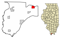
Location of Karnak in Pulaski County, Illinois.
Illinois in United States (US48).svg
Location of Illinois in the United States
Coordinates: 37°17′32″N88°58′30″W / 37.29222°N 88.97500°W / 37.29222; -88.97500
CountryUnited States
StateIllinois
County Pulaski
Area
[1]
  Total1.81 sq mi (4.69 km2)
  Land1.81 sq mi (4.68 km2)
  Water0.00 sq mi (0.01 km2)
Elevation
[2]
341 ft (104 m)
Population
 (2020)
  Total430
  Density238.10/sq mi (91.92/km2)
Time zone UTC-6 (CST)
  Summer (DST) UTC-5 (CDT)
ZIP Code(s)
62956
Area code 618
FIPS code 17-39077
GNIS feature ID2398329 [2]
Wikimedia CommonsKarnak, Illinois

Karnak is a village in Pulaski County, Illinois, United States. The population was 499 at the 2010 census.

Contents

History

A post office called Karnak has been in operation since 1905. [3] The village was named after Karnak, in Egypt. [4]

Geography

Karnak is located at 37°17′32″N88°58′30″W / 37.29222°N 88.97500°W / 37.29222; -88.97500 (37.292146, -88.974920). [5]

According to the 2010 census, Karnak has a total area of 1.814 square miles (4.70 km2), of which 1.81 square miles (4.69 km2) (or 99.78%) is land and 0.004 square miles (0.01 km2) (or 0.22%) is water. [6]

Demographics

Historical population
CensusPop.Note
1920 613
1930 77125.8%
1940 89315.8%
1950 792−11.3%
1960 667−15.8%
1970 641−3.9%
1980 6460.8%
1990 581−10.1%
2000 6196.5%
2010 499−19.4%
2020 430−13.8%
U.S. Decennial Census [7]

As of the census [8] of 2000, there were 619 people, 263 households, and 174 families residing in the village. The population density was 341.4 inhabitants per square mile (131.8/km2). There were 293 housing units at an average density of 161.6 per square mile (62.4/km2). The racial makeup of the village was 93.70% White, 5.49% African American, 0.16% Asian, 0.65% from other races. Hispanic or Latino of any race were 3.88% of the population.

There were 263 households, out of which 27.4% had children under the age of 18 living with them, 49.8% were married couples living together, 13.7% had a female householder with no husband present, and 33.8% were non-families. 30.0% of all households were made up of individuals, and 16.7% had someone living alone who was 65 years of age or older. The average household size was 2.35 and the average family size was 2.90.

In the village, the population was spread out, with 25.7% under the age of 18, 7.9% from 18 to 24, 25.2% from 25 to 44, 19.7% from 45 to 64, and 21.5% who were 65 years of age or older. The median age was 38 years. For every 100 females, there were 82.1 males. For every 100 females age 18 and over, there were 78.3 males.

The median income for a household in the village was $28,125, and the median income for a family was $33,833. Males had a median income of $35,625 versus $16,635 for females. The per capita income for the village was $13,346. About 16.3% of families and 20.0% of the population were below the poverty line, including 27.4% of those under age 18 and 14.2% of those age 65 or over.

Related Research Articles

<span class="mw-page-title-main">Pulaski County, Illinois</span> County in Illinois, United States

Pulaski County is a county located in the U.S. state of Illinois. According to the 2020 census, it had a population of 5,193. Its county seat is Mound City. Its largest city is Mounds. It is located along the Ohio River in the southwestern portion of the state, known locally as "Little Egypt".

<span class="mw-page-title-main">Noatak, Alaska</span> Place in Alaska, United States

Noatak is a census-designated place (CDP) in the Northwest Arctic Borough in the U.S. state of Alaska. The population was 570 at the 2020 census, up from 514 in 2010. It is served by Noatak Airport.

<span class="mw-page-title-main">Weston, Idaho</span> City in Idaho, United States

Weston is a city in Franklin County, Idaho, United States. The population was 437 at the 2010 census. It is part of the Logan, Utah-Idaho Metropolitan Statistical Area. It was first settled in 1865. The community was so named on account of its location at the west bank of the Bear River.

<span class="mw-page-title-main">Godley, Illinois</span> Village in Illinois, United States

Godley is a village in Grundy and Will counties, Illinois, United States. The population was 601 at the 2010 census.

<span class="mw-page-title-main">Belknap, Illinois</span> Village in Illinois, United States

Belknap is a village in Johnson County, Illinois, United States. The population was 104 at the 2010 census.

<span class="mw-page-title-main">Buncombe, Illinois</span> Village in Illinois, United States

Buncombe is a village in Johnson County, Illinois, United States. The population was 203 at the 2010 census and as of 2018, the population had declined to an estimated 173.

<span class="mw-page-title-main">New Grand Chain, Illinois</span> Village in Illinois, United States

Grand Chain is a village in Pulaski County, Illinois, United States. The population was 190 at the 2010 census. The village's official name changed from "Grand Chain" to "New Grand Chain" in the 1970s, but its residents continue to refer to it as "Grand Chain."

<span class="mw-page-title-main">Olmsted, Illinois</span> Village in Illinois, United States

Olmsted is a village in Pulaski County, Illinois, along the Ohio River. The population was 299 at the 2000 census.

<span class="mw-page-title-main">Pulaski, Illinois</span> Village in Illinois, United States

Pulaski is a village in Pulaski County, Illinois, United States. The population was 235 at the 2010 census. The village is named in honor of Polish Revolutionary War hero Casimir Pulaski.

<span class="mw-page-title-main">Pulaski, Iowa</span> City in Iowa, United States

Pulaski is a city in Davis County, Iowa, United States. The population was 264 at the time of the 2020 census.

<span class="mw-page-title-main">LaCenter, Kentucky</span> City in Kentucky, United States

LaCenter, formerly and often informally written as La Center, is a home rule-class city in Ballard County, Kentucky, in the United States. The population was 1,009 at the 2010 census, making it the most populous community in the county. It is part of the Paducah micropolitan area.

<span class="mw-page-title-main">Pulaski Township, Michigan</span> Civil township in Michigan, United States

Pulaski Township is a civil township of Jackson County in the southern portion of the U.S. state of Michigan. As of the 2010 census, the township population was 2,075.

<span class="mw-page-title-main">Minto, North Dakota</span> City in North Dakota, United States

Minto is a city in Walsh County, North Dakota, United States. The population was 616 at the 2020 census. Minto was founded in 1881.

<span class="mw-page-title-main">Waynesfield, Ohio</span> Village in Ohio, United States

Waynesfield is a village in Auglaize County, Ohio, United States. The population was 749 at the 2020 census. It is included in the Wapakoneta, Ohio Micropolitan Statistical Area.

<span class="mw-page-title-main">Helena, Ohio</span> Village in Ohio, United States

Helena is a village in Sandusky County, Ohio, United States. The population was 224 at the 2010 census.

<span class="mw-page-title-main">Pittsfield, Wisconsin</span> Town in Wisconsin, United States

Pittsfield is a town in Brown County in the U.S. state of Wisconsin. The population was 2,608 at the 2010 census.

<span class="mw-page-title-main">Blanchester, Ohio</span> Village in Ohio, United States

Blanchester is a village in Clinton and Warren counties in the U.S. state of Ohio. The population was 4,224 at the 2020 census. Blanchester is part of the Wilmington, Ohio Micropolitan Statistical Area, which is also included in the Cincinnati-Wilmington-Maysville, OH-KY-IN Combined Statistical Area.

<span class="mw-page-title-main">Pulaski, Wisconsin</span> Village in Wisconsin, United States

Pulaski is a village in Brown, Oconto, and Shawano counties in the U.S. state of Wisconsin. The population was 3,539 at the 2010 census. Of this, 3,321 were in Brown County, 218 in Shawano County, and none in Oconto County.

<span class="mw-page-title-main">Wyocena (town), Wisconsin</span>

Wyocena is a town in Columbia County, Wisconsin, United States. The population was 619 at the 2000 Census. The Village of Wyocena is located within the town.

Dexter is a census-designated place (CDP) comprising the main settlement within the town of Dexter in Penobscot County, Maine, United States. The population of the CDP was 2,158 at the 2010 census.

References

  1. "2020 U.S. Gazetteer Files". United States Census Bureau. Retrieved March 15, 2022.
  2. 1 2 U.S. Geological Survey Geographic Names Information System: Karnak, Illinois
  3. "Pulaski County". Jim Forte Postal History. Retrieved April 27, 2015.
  4. Allen, John W. (January 11, 1963). "Place Names Have Colorful History". The Southeast Missourian. p. 6. Retrieved April 27, 2015.
  5. "US Gazetteer files: 2010, 2000, and 1990". United States Census Bureau. February 12, 2011. Retrieved April 23, 2011.
  6. "G001 - Geographic Identifiers - 2010 Census Summary File 1". United States Census Bureau. Archived from the original on February 13, 2020. Retrieved August 4, 2015.
  7. "Census of Population and Housing". Census.gov. Retrieved June 4, 2015.
  8. "U.S. Census website". United States Census Bureau . Retrieved January 31, 2008.