Burlington, Iowa

Last updated

Burlington, Iowa
Shoquoquon
Flint Hills
City
BurlingtonIA Skyline cropped.jpg
Downtown Burlington from Mississippi River
Flag of the City of Burlington, Iowa.gif
Des Moines County Iowa Incorporated and Unincorporated areas Burlington Highlighted.svg
Location in the state of Iowa
Coordinates: 40°48′29″N91°6′57″W / 40.80806°N 91.11583°W / 40.80806; -91.11583
CountryUnited States
StateFlag of Iowa.svg  Iowa
County Des Moines
Founded1833
Government
  MayorJon D. Billups
   City Council Linda Murrey (Mayor Pro Tem)
Matthew Rinker
Bill Maupin
Robert Critser
Area
[1]
  Total15.17 sq mi (39.29 km2)
  Land14.41 sq mi (37.32 km2)
  Water0.76 sq mi (1.98 km2)
Elevation
696 ft (185 m)
Population
 (2020)
  Total23,982
  Density1,664.49/sq mi (642.68/km2)
   Demonym
Burlingtonian
Time zone UTC−6 (CST)
  Summer (DST) UTC−5 (CDT)
ZIP code
52601
Area code 319
FIPS code 19-09550
GNIS feature ID0454995
Website burlingtoniowa.org

Burlington is a city in, and the county seat of, Des Moines County, Iowa, United States. [2] The population was 23,982 in the 2020 census, a decline from the 26,839 population in 2000. [3] Burlington is the center of a micropolitan area, which includes West Burlington and Middletown, Iowa, and Gulfport, Illinois. Burlington is the home of Snake Alley, the crookedest street in the world.

Contents

History

Prior to European settlement, the area was neutral territory for the Sac and Fox Native American tribes, who called it Shoquoquon (Shok-ko-kon), meaning Flint Hills. [4]

In 1803, President Thomas Jefferson organized two parties of explorers to map the Louisiana Purchase. The Lewis and Clark Expedition followed the Missouri River, while Lt. Zebulon Pike followed the Mississippi River. In 1805, Pike landed at the bluffs below Burlington and raised the United States Flag for the first time on what would become Iowa soil and recommended construction of a fort. The recommendation went unheeded.

Burlington in 1865. Burlington IA Barber 1865p525 cropped.jpg
Burlington in 1865.

The American Fur Company of John Jacob Astor established a post in the area in 1829. Settlement began in 1833, shortly after the Black Hawk Purchase, when Samuel (aka Simpson) White, Amzi Doolitle, and Morton M. McCarver crossed the Mississippi River from Big Island and staked claims there. [5] [6] [7] According to an account A.T. Andreas wrote in 1875,[ citation needed ] White erected a cabin in the area, later platted to be Front Street between Court and High streets. Andreas called White and Doolittle the Romulus and Remus of their settlement, referring to the mythic heroes who founded Rome, a city surrounded by hills. A few weeks later, William R. Ross joined them and established a general store. In November and December, he surveyed the settlement for White and Doolittle. [8] :145

In the spring of 1834 they allowed John Gray, who purchased the first lot with his wife Eliza Jane, to rename the town for $50. Gray chose to name it Burlington in honor of his hometown in Vermont. [9] The Grays' daughter Abigail was born in Burlington that same year, the first European-descended American settler child born on Iowa soil. [lower-alpha 1] [ citation needed ]

In 1837, Burlington was designated the second territorial capital of the Wisconsin Territory. [10] The Iowa Territory was organized in the following year, and Burlington was named as its first territorial capital. [11] The government used "Old Zion," the first Methodist Church in Iowa (located near what is now Third and Washington streets), to conduct its business. A historical marker commemorates the site of the church and early territorial government.

On May 22, 1849, Maj. William Williams visited Burlington, writing a brief description in his journal: [12]

This town [was] originally called Flint Hill- the Indian name was Shoquokon, Flint or Rock Hill. [It is] beautifully elevated, situated on the west side of the Mississippi River, a place of very considerable business. The town is very well built. Houses are good, generally taste[ful], brick dwellings. A great many handsome residences on the more elevated parts of the bluff. The number of inhabitants between 3,000 and 3,500. ... Was the first seat of government after the formation of the Territory of Iowa. The view of the city is extremely picturesque from the river. The main part of the city is situated like an amphitheater formed by the surrounding hills, beautiful buildings and private residences on the eminences around. From the location of Burlington it must always be a place of considerable trade. The city is well built [in the] modern style, a very intelligent population... The river here is over 3/4 of mile wide and steam ferry boats constantly plying between this and the Illinois shore.

Maj. William Williams
Lady Liberty of Burlington Lady Liberty of Burlington.jpg
Lady Liberty of Burlington

In April 1885, economist Henry George gave a speech titled "The Crime of Poverty" at the Burlington Knights of Labor local advocating for a citizen's dividend paid for by a land value tax. [13]

Iowa's nickname, "The Hawkeye State," has its roots in Burlington. At Judge David Rorer's suggestion, publisher James G. Edwards changed The Iowa Patriot newspaper's name to The Hawk-Eye and Iowa Patriot in tribute to his friend, Chief Black Hawk. Rorer is said to have found the name in James Fenimore Cooper's The Last of the Mohicans, but Edwards proposed the nickname to "...rescue from oblivion [ sic ] a momento [ sic ], at least of the name of the old chief." [14]

Burlington was a bustling river port in the steamboat era and a central city to the Chicago, Burlington and Quincy Railroad. The "Burlington Route" (1848–1970) merged into the Burlington Northern Railroad (1970–1996), which in turn merged into the BNSF Railway (1997–present). The "Burlington" name has been given to one of the United States' largest railroads. One of BNSF's main east-west lines, the Ottumwa subdivision, still crosses the Mississippi at Burlington.

In 1970, the community had its highest ever population. [15]

In the late twentieth century, retail expanded with suburbanization of the population. After purchasing Benner Tea, Aldi opened its first store in the United States at Burlington in 1976. [16] [17] Westland Mall opened in nearby West Burlington in 1977.

Geography

According to the United States Census Bureau, the city has a total area of 15.24 square miles (39.47 km2), of which 14.48 square miles (37.50 km2) is land and 0.76 square miles (1.97 km2) is water. [18]

Climate

Climate data for Burlington, Iowa (Southeast Iowa Regional Airport) 1991–2020 normals, extremes 1897–present
MonthJanFebMarAprMayJunJulAugSepOctNovDecYear
Record high °F (°C)70
(21)
76
(24)
88
(31)
93
(34)
103
(39)
105
(41)
111
(44)
110
(43)
103
(39)
95
(35)
86
(30)
73
(23)
111
(44)
Mean maximum °F (°C)55.3
(12.9)
59.9
(15.5)
74.2
(23.4)
82.6
(28.1)
88.7
(31.5)
93.1
(33.9)
94.7
(34.8)
94.6
(34.8)
91.4
(33.0)
84.3
(29.1)
70.6
(21.4)
59.3
(15.2)
96.8
(36.0)
Mean daily maximum °F (°C)32.3
(0.2)
37.2
(2.9)
50.2
(10.1)
62.8
(17.1)
73.1
(22.8)
82.3
(27.9)
85.2
(29.6)
83.5
(28.6)
77.5
(25.3)
64.5
(18.1)
49.8
(9.9)
37.4
(3.0)
61.3
(16.3)
Daily mean °F (°C)24.3
(−4.3)
28.8
(−1.8)
40.7
(4.8)
52.3
(11.3)
63.0
(17.2)
72.5
(22.5)
75.6
(24.2)
73.8
(23.2)
66.7
(19.3)
54.2
(12.3)
41.0
(5.0)
29.9
(−1.2)
51.9
(11.0)
Mean daily minimum °F (°C)16.4
(−8.7)
20.5
(−6.4)
31.1
(−0.5)
41.9
(5.5)
52.9
(11.6)
62.6
(17.0)
66.0
(18.9)
64.0
(17.8)
55.8
(13.2)
44.0
(6.7)
32.3
(0.2)
22.3
(−5.4)
42.5
(5.8)
Mean minimum °F (°C)−6.6
(−21.4)
0.4
(−17.6)
10.8
(−11.8)
26.8
(−2.9)
38.0
(3.3)
50.4
(10.2)
55.5
(13.1)
53.6
(12.0)
40.0
(4.4)
27.6
(−2.4)
15.1
(−9.4)
0.9
(−17.3)
−10.9
(−23.8)
Record low °F (°C)−24
(−31)
−27
(−33)
−13
(−25)
11
(−12)
26
(−3)
39
(4)
46
(8)
41
(5)
23
(−5)
10
(−12)
−2
(−19)
−22
(−30)
−27
(−33)
Average precipitation inches (mm)1.45
(37)
1.69
(43)
2.43
(62)
3.92
(100)
4.93
(125)
4.87
(124)
4.02
(102)
3.77
(96)
3.53
(90)
3.09
(78)
2.29
(58)
1.87
(47)
37.86
(962)
Average snowfall inches (cm)6.7
(17)
6.5
(17)
1.9
(4.8)
0.1
(0.25)
0.0
(0.0)
0.0
(0.0)
0.0
(0.0)
0.0
(0.0)
0.0
(0.0)
0.0
(0.0)
0.8
(2.0)
7.5
(19)
23.5
(60.05)
Average precipitation days (≥ 0.01 in)8.08.29.911.813.211.49.89.17.59.38.07.5113.7
Average snowy days (≥ 0.1 in)4.75.11.80.10.00.00.00.00.00.01.34.517.5
Source: NOAA [19] [20] [21]
Climate data for Burlington 2S, Iowa (1991–2020 normals, extremes 1964–present)
MonthJanFebMarAprMayJunJulAugSepOctNovDecYear
Record high °F (°C)70
(21)
74
(23)
88
(31)
92
(33)
98
(37)
104
(40)
105
(41)
105
(41)
101
(38)
93
(34)
79
(26)
74
(23)
105
(41)
Mean maximum °F (°C)56.0
(13.3)
60.4
(15.8)
73.0
(22.8)
81.1
(27.3)
88.0
(31.1)
92.6
(33.7)
95.1
(35.1)
94.5
(34.7)
91.4
(33.0)
83.9
(28.8)
69.4
(20.8)
58.7
(14.8)
97.0
(36.1)
Mean daily maximum °F (°C)32.0
(0.0)
37.1
(2.8)
49.9
(9.9)
62.3
(16.8)
72.7
(22.6)
81.8
(27.7)
85.0
(29.4)
83.4
(28.6)
77.1
(25.1)
64.5
(18.1)
49.6
(9.8)
36.9
(2.7)
61.0
(16.1)
Daily mean °F (°C)23.5
(−4.7)
28.1
(−2.2)
39.7
(4.3)
51.4
(10.8)
62.3
(16.8)
71.7
(22.1)
75.3
(24.1)
73.4
(23.0)
66.2
(19.0)
53.9
(12.2)
40.3
(4.6)
28.8
(−1.8)
51.2
(10.7)
Mean daily minimum °F (°C)15.0
(−9.4)
19.1
(−7.2)
29.6
(−1.3)
40.5
(4.7)
51.9
(11.1)
61.7
(16.5)
65.6
(18.7)
63.5
(17.5)
55.2
(12.9)
43.3
(6.3)
31.0
(−0.6)
20.7
(−6.3)
41.4
(5.2)
Mean minimum °F (°C)−6.0
(−21.1)
−0.1
(−17.8)
9.6
(−12.4)
26.3
(−3.2)
38.9
(3.8)
50.3
(10.2)
56.8
(13.8)
55.0
(12.8)
40.8
(4.9)
28.9
(−1.7)
14.9
(−9.5)
1.5
(−16.9)
−9.4
(−23.0)
Record low °F (°C)−23
(−31)
−26
(−32)
−9
(−23)
11
(−12)
28
(−2)
40
(4)
46
(8)
42
(6)
30
(−1)
18
(−8)
−2
(−19)
−20
(−29)
−26
(−32)
Average precipitation inches (mm)1.72
(44)
1.90
(48)
2.80
(71)
4.24
(108)
5.16
(131)
5.14
(131)
4.34
(110)
3.87
(98)
3.89
(99)
3.25
(83)
2.57
(65)
2.14
(54)
41.02
(1,042)
Average snowfall inches (cm)6.3
(16)
5.8
(15)
2.1
(5.3)
0.9
(2.3)
0.0
(0.0)
0.0
(0.0)
0.0
(0.0)
0.0
(0.0)
0.0
(0.0)
0.1
(0.25)
1.3
(3.3)
5.3
(13)
21.8
(55.15)
Average precipitation days (≥ 0.01 in)9.08.69.511.412.611.39.68.97.39.18.57.9113.7
Average snowy days (≥ 0.1 in)4.33.61.40.30.00.00.00.00.00.00.83.113.5
Source: NOAA [19] [22]

Demographics

Historical population
CensusPop.Note
1850 4,082
1860 6,70664.3%
1870 14,930122.6%
1880 19,45030.3%
1890 22,56516.0%
1900 23,2012.8%
1910 24,3244.8%
1920 24,057−1.1%
1930 26,75511.2%
1940 25,832−3.4%
1950 30,61318.5%
1960 32,4305.9%
1970 32,366−0.2%
1980 29,529−8.8%
1990 27,208−7.9%
2000 26,839−1.4%
2010 25,663−4.4%
2020 23,982−6.6%
U.S. Decennial Census [23] [3]
The population of Burlington, Iowa from US census data BurlingtonIowaPopPlot.png
The population of Burlington, Iowa from US census data

2010 census

As of the 2010 census, [24] there were 25,663 people, 10,938 households, and 6,693 families residing in the city. The population density was 1,772.3 inhabitants per square mile (684.3/km2). There were 11,899 housing units at an average density of 821.8 per square mile (317.3/km2). The racial makeup of the city was 81.2% White, 14.2% African American, 0.3% Native American, 0.8% Asian, 0.1% Pacific Islander, 0.7% from other races, and 2.9% from two or more races. Hispanic or Latino of any race were 3.1% of the population.

There were 10,938 households, of which 29.8% had children under the age of 18 living with them, 41.9% were married couples living together, 14.2% had a female householder with no husband present, 5.1% had a male householder with no wife present, and 38.8% were non-families. 32.5% of all households were made up of individuals, and 14.1% had someone living alone who was 65 years of age or older. The average household size was 2.30 and the average family size was 2.89.

The median age in the city was 39.7 years. 23.7% of residents were under the age of 18; 7.7% were between the ages of 18 and 24; 24.6% were from 25 to 44; 26.5% were from 45 to 64; and 17.4% were 65 years of age or older. The gender makeup of the city was 48.1% male and 51.9% female.

2000 census

As of the 2000 census, [25] there were 26,839 people, 11,102 households, and 7,105 families residing in the city. The population density was 1,910.1 inhabitants per square mile (737.5/km2). There were 11,985 housing units at an average density of 853.0 per square mile (329.3/km2). The racial makeup of the city was 86.6% White, 10.0% African American, 0.33% Native American, 0.66% Asian, 0.04% Pacific Islander, 0.90% from other races, and 1.43% from two or more races. Hispanic or Latino of any race were 2.06% of the population.

There were 11,102 households, out of which 29.2% had children under the age of 18 living with them, 48.2% were married couples living together, 12.0% had a female householder with no husband present, and 36.0% were non-families. 31.0% of all households were made up of individuals, and 14.0% had someone living alone who was 65 years of age or older. The average household size was 2.36 and the average family size was 4.94.

Age spread: 24.5% under the age of 18, 8.9% from 18 to 24, 26.7% from 25 to 44, 22.7% from 45 to 64, and 17.2% who were 65 years of age or older. The median age was 38 years. For every 100 females, there were 90.9 males. For every 100 females age 18 and over, there were 87.2 males.

The median income for a household in the city was $33,770, and the median income for a family was $40,912. Males had a median income of $33,238 versus $23,003 for females. The per capita income for the city was $19,450. About 10.0% of families and 12.6% of the population was below the poverty line, including 20.9% of those under age 18 and 8.9% of those age 65 or over.

Economy

Burlington's roots are in transportation and manufacturing. Manufacturing plants are among the largest employers in the area, including companies such as American Ordnance LLC, Case Corporation, ABB (formerly General Electric), Champion Spark Plugs, Shearer's Foods and Winegard Company. The largest employer in the area is the Great River Medical Center. Among the oldest businesses in Burlington, the Murray factory (now Murray Turbomachinery and owned by Dresser-Rand) which has been in operation in Burlington since before 1900, the original building on Central St. and Washington St. which was divided by the local train tracks, was recently razed. Another long-lived business is Case Corporation, which has been at its current location on Des Moines Avenue, approximately a quarter-mile from the Mississippi River, since 1937. The first backhoes rolled off the assembly line at the Burlington plant in 1957, which is now the only plant in the United States that produces the Case Loader/Backhoe, giving Burlington the nickname "Backhoe Capital of the World." Case is now a division of the Italian holding group CNH Industrial. Employment at Case peaked in the 1980s, according to the Des Moines Register, then declined after "Case initiated a wave of buyouts and early retirements in the 1990s and early 2000s, and ended the contract with the union in 2004"; but in May 2010, the Register reports, Case announced that "it will open a new line that builds corn-picker heads for combines, as early as [Spring, 2012]" and that by mid-2013 it will add more than 200 positions. [26]

Over the last several years, several businesses have either left the area or relocated elsewhere. These businesses include Exide, makers of vehicle batteries, CAT, Case Corporation's closest competitor in American made construction equipment, and Lehigh-Leopold, makers of office furniture. This has left some former manufacturing plants around the city empty, but other businesses have moved into them; PPG, maker of auto safety glass has moved into the former CAT plant, and a warehouse has moved into the former Leopold building. In March 2012, the Des Moines Register reported that "Unemployment here is 7.6 percent, compared with the 5.4 percent state average". [26]

In 2022 Ben Jacobs of The New Republic wrote that the area's economy had more problems related to late 20th century globalization compared to that of Dubuque, Iowa. [27]

Downtown Burlington

Capitol Theater Capitol Theater - Burlington Iowa.jpg
Capitol Theater

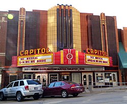
The downtown area holds a number of buildings listed on the National Register of Historic Places, among them the Burlington Apartments (listed as the Hotel Burlington), the Burlington Railroad Depot, the Des Moines County Courthouse, the Burlington Fire Department central station, the Port of Burlington building, Memorial Auditorium, River Park Place (as Burlington Mercy Hospital), the former Burlington Police Department building. It is perhaps best known for Snake Alley, the most crooked street in the US. [28] (as Burlington Paper Company), The Capitol Theater, First Congregational Church, St. Paul's Catholic Church and several others. The downtown skyline is noted for its several church spires. [29]

Sports

The Burlington Bees play the Swing of the Quad Cities in this July 2004 game at Burlington Community Field. Burlington community field1.JPG
The Burlington Bees play the Swing of the Quad Cities in this July 2004 game at Burlington Community Field.
Snake Alley SnakeAlley BurlingtonIA.jpg
Snake Alley

Burlington is the home of the Burlington Bees baseball team, a member of the Prospect League, a collegiate summer baseball league. [30] They were previously members of Minor League Baseball's Class A Midwest League until Major League Baseball's reorganization of the minor leagues after the 2020 season. [31] The Bees play at Community Field, which underwent extensive renovation in 2005.

Burlington hosts the Snake Alley Criterium, one of the most physically challenging races in the Midwest. The annual event is held on a 15-block course, with differences in elevation from 555 feet to 678 feet. The course is entirely on city streets, mostly in the downtown commercial area. A one-block-long climb is on the historic brick street named Snake Alley. The 276-foot-long Snake Alley has five switchbacks in a 60-foot climb. The average grade is 12.5 percent in that one block.

Burlington has been the finishing point for RAGBRAI twice. the annual bicycle ride that starts at the Missouri River in western Iowa and ends in eastern Iowa at the Mississippi River.

Burlington is also the home of the Burlington High School and Notre Dame High School sports teams. Also in the Burlington area are the sports teams of Southeastern Community College, which have had a successful history, including three men's basketball national championships.

Many people living in the area support athletic teams from Saint Louis, Missouri, differing from other parts of Iowa, which support other sports teams. [27]

Education

Burlington is served by the Burlington Community School District, which has five elementary schools, one intermediate school, one middle school, one high school and one alternative high school. Private education is also available for kindergarten through 12th grade at Notre Dame Catholic School and Great River Christian School (GRCS).

In 1833 the first school facility for Burlington opened in a log cabin. School District No. 2 of the Township of Burlington was established on March 29, 1849. [32]

The Burlington School District has five elementary schools: North Hill, Sunnyside, Grimes, Corse and Black Hawk. All are new buildings or have been recently completely rehabilitated, the newest, North Hill Elementary, received its first students in 2009, there are no elementary school buildings within the school district that are over 40 years old.[ when? ] The district has two middle schools: Edward Stone and Aldo Leopold. Beginning with the 2010–11 school year, students who had attended Oak Street Middle School (an aging building that was completed around 1907) began attending Aldo Leopold (named in honor of ecologist, and environmentalist, Aldo Leopold, a former resident of Burlington, and author of " A Sand County Almanac "), the new school building is located near the corner of Sunnyside Avenue, and Roosevelt Avenue. Edward Stone, which opened at the start of the 2012–13 school year, is located near the corner of Lawrence Drive and Mason Road. The middle school was named in honor of former JPL head, and Burlington educated Dr. Edward Stone. This building replaced the James Madison Middle School building, which has only been in the system since the mid-1960s. These two new middle schools were built to accommodate more students after a third building, Horace Mann, was gutted by fire in 2005.

Burlington Community High School was constructed in 1968, and occupied the following year, with the first graduating class in June 1970. Prior to that, the high school students were educated at the former Apollo High School building located near the downtown business district; the building is still standing and for a time served as Burlington Alternative High School, but has been unoccupied since 1996. Notre Dame High School and Elementary schools occupy a building near the Burlington high school. Great River Christian Schools occupies the old Prospect Hill Elementary School building, 426 Harrison St. A third middle school building once existed on the edge of Perkins Park, named Horace Mann, that building was gutted by fire in 2005, and later razed. The school district offices are located near the corner of West Avenue, and White Street, in a large mansion once owned by Railroad tycoon Charles Elliott Perkins, and is nicknamed "The White House," due to the whitewashed facade. The original High School building (which now serves as the School District Maintenance shops) is noted as being the first high school built west of the Mississippi River.

Burlington is also served by Southeastern Community College.

The Burlington Public Library serves the community.

Media

Burlington, Iowa is served by the following local media outlets:

Newspaper
Radio

Burlington's radio stations include WQKQ 92.1 FM, KAYP 89.9 FM, KKMI 93.5 FM, KCDM 98.3 FM, KDMG 103.1 FM, KBKB 101.7 FM, KHDK 97.3 FM, KGRS 107.3 FM, KCPS 1150 AM, KBKB 1360 AM, and KBUR 1490 AM. Burlington residents also listen to stations in nearby communities, most notably, the Quad Cities.

TV

Burlington previously had a local TV station, KJMH. It signed on August 2, 1984, from a tower on Winegard Drive. It also had studios in Burlington. Initially an independent station, it became a charter FOX affiliate in 1986, but suffered from duplication from KLJB in the Quad Cities. In 1996, the station became a full-time satellite of KLJB, marking the end of local broadcast TV in Burlington. Today, those in the Burlington-Oquawka area receive local over-the-air programming from stations in the Quad Cities (the city's main television market), Quincy, and Ottumwa, including the stations listed below.

Transportation

Roadways

Great River Bridge in Burlington Great River Bridge Burlington Iowa 1997.jpg
Great River Bridge in Burlington

The town is served by U.S. Route 34, which is the freeway that bisects the city, and U.S. Route 61. Iowa Highways 99 and 406 served the town before they were decommissioned in 2003. The two still exist as county roads.

Transit

Burlington Urban Service (B.U.S.) is a transportation system owned and operated by the City of Burlington. Routes service nearly all areas of Burlington, and nearly 90% of all residents live within three city blocks of a bus route. Burlington Trailways provides daily intercity bus service from its West Burlington hub.

Rail service

Amtrak, the national passenger rail system, provides service to Burlington, operating its California Zephyr [34] daily in both directions between Chicago, Illinois, and Emeryville, California, across the bay from San Francisco. The older Burlington and Missouri River Railroad Passenger Station exists nearby and is also listed on the NRHP.

Airport

The Southeast Iowa Regional Airport (IATA code BRL), is located about five miles south of downtown. Quad City International Airport, the area's large international airport, is approximately 70 miles north of the city, in Moline, Illinois.

Notable people

Sister cities

Burlington has one sister city, as designated by Sister Cities International:

Notes

  1. John Gray was of European descent. Eliza Jane Gray was of mixed African American and Native American heritage.

See also

Related Research Articles

<span class="mw-page-title-main">Davenport, Iowa</span> City in Iowa, United States

Davenport is a city in and the county seat of Scott County, Iowa, United States. Located along the Mississippi River on the eastern border of the state, it is the largest of the Quad Cities, a metropolitan area with a population of 384,324 and a combined statistical area population of 474,019, ranking as the 147th-largest MSA and 91st-largest CSA in the nation. According to the 2020 census, the city had a population of 101,724, making it Iowa's third-most populous city after Des Moines and Cedar Rapids. Davenport was founded on May 14, 1836, by Antoine Le Claire and named for his friend George Davenport.

<span class="mw-page-title-main">Des Moines, Iowa</span> Capital of Iowa, United States

Des Moines is the capital and most populous city in the U.S. state of Iowa. It is the county seat of Polk County with parts extending into Warren County. It was incorporated on September 22, 1851, as Fort Des Moines, which was shortened to "Des Moines" in 1857. It is located on, and named after, the Des Moines River, which likely was adapted from the early French name, Rivière des Moines, meaning "River of the Monks". The city's population was 214,133 as of the 2020 census. The six-county metropolitan area is ranked 81st in terms of population in the United States, with 709,466 residents according to the 2020 census by the United States Census Bureau, and is the largest metropolitan area fully located within the state.

<span class="mw-page-title-main">Quad Cities</span> Metropolitan area in the United States

The Quad Cities is a region of cities in the U.S. states of Iowa and Illinois: Davenport and Bettendorf in southeastern Iowa, and Rock Island, Moline and East Moline in northwestern Illinois. These cities are the center of the Quad Cities metropolitan area, a region within the Mississippi River Valley, which as of 2013 had a population estimate of 383,781 and a Combined Statistical Area (CSA) population of 474,937, making it the 90th-largest CSA in the nation.

<span class="mw-page-title-main">Midwest League</span> American Minor League baseball league

The Midwest League is a Minor League Baseball league established in 1947 and based in the Midwestern United States. A Class A league for most of its history, the league was promoted to High-A as part of Major League Baseball's 2021 reorganization of the minor leagues.

<span class="mw-page-title-main">Des Moines County, Iowa</span> County in Iowa, United States

Des Moines County is located in the U.S. state of Iowa. As of the 2020 census, the population was 38,910. The county seat and largest city is Burlington. It is one of Iowa's two original counties along with Dubuque County; both were organized by the Michigan Territorial legislature in 1834.

<span class="mw-page-title-main">Galesburg, Illinois</span> City in Illinois, United States

Galesburg is a city in Knox County, Illinois, United States. The city is 45 miles (72 km) northwest of Peoria. At the 2010 census, its population was 32,195. It is the county seat of Knox County and the principal city of the Galesburg Micropolitan Statistical Area, which includes all of Knox and Warren counties.

<span class="mw-page-title-main">Iowa City, Iowa</span> City in Iowa, United States

Iowa City is the county seat and largest city of Johnson County, Iowa, United States. It is the home of the University of Iowa and county seat of Johnson County, at the center of the Iowa City Metropolitan Statistical Area. At the time of the 2020 census the population was 74,828, making it the state's fifth-most populous city. The metropolitan area, which encompasses Johnson and Washington counties, has a population of over 171,000. The Iowa City Metropolitan Statistical Area (MSA) is also a part of a Combined Statistical Area (CSA) with the Cedar Rapids MSA. This CSA plus two additional counties are known as the Iowa City-Cedar Rapids region which collectively has a population of nearly 500,000.

<span class="mw-page-title-main">Cedar Rapids, Iowa</span> City in Iowa, United States

Cedar Rapids is the second-most populous city in Iowa, United States and is the county seat of Linn County. The city lies on both banks of the Cedar River, 20 miles (32 km) north of Iowa City and 128 miles (206 km) northeast of Des Moines, the state's capital and largest city. It is a part of the Cedar Rapids/Iowa City region of Eastern Iowa, which includes Linn, Benton, Cedar, Iowa, Jones, Johnson, and Washington counties.

<span class="mw-page-title-main">Ottumwa, Iowa</span> City in Iowa, United States

Ottumwa is a city in and the county seat of Wapello County, Iowa, United States. The population was 25,529 at the time of the 2020 U.S. Census. Located in the state's southeastern section, the city is split into northern and southern halves by the Des Moines River.

<span class="mw-page-title-main">Community Field</span> Stadium in Burlington, Iowa

Community Field is a stadium in Burlington, Iowa. It is primarily used for baseball and is the home field of the Burlington Bees collegiate summer baseball team of the Prospect League. Occasionally, the stadium is used by the local high school baseball team. The current stadium holds 3,200 people. Community Field was most recently named the 2013 "Field of the Year" in the state of Iowa by the Iowa Sports Turf Management Association.

<span class="mw-page-title-main">Southeast Iowa Regional Airport</span> Airport

Southeast Iowa Regional Airport is a public airport located two miles southwest of Burlington, in Des Moines County, Iowa. It is owned by the Southeast Iowa Regional Airport Authority which includes representatives from the city of Burlington, the city of West Burlington, and Des Moines County. The airport is used for general aviation and sees one airline, a service subsidized by the federal government's Essential Air Service program at a cost of $1,917,566.

The Illinois–Indiana–Iowa League was a Minor League Baseball organization that operated for the better part of 60 seasons, with teams based in Illinois, Indiana, Iowa, Kansas, Minnesota, Missouri, Nebraska and Wisconsin. The league began play in 1901 and disbanded after the 1961 season. It was popularly known as the Three–I League and sometimes as the Three–Eye League.

KWQC-TV is a television station licensed to Davenport, Iowa, United States, serving the Quad Cities area as an affiliate of NBC. Owned by Gray Television, the station maintains studios on Brady Street in downtown Davenport, and its transmitter is located near Orion, Illinois.

<span class="mw-page-title-main">KGCW</span> CW TV station in Burlington, Iowa

KGCW is a television station licensed to Burlington, Iowa, United States, serving as the CW network outlet for the Quad Cities area. It is owned and operated by network majority owner Nexstar Media Group alongside regional CBS affiliate WHBF-TV. Nexstar also provides certain services to Fox affiliate KLJB under a shared services agreement (SSA) with Mission Broadcasting. The stations share studios in the Telco Building on 18th Street in downtown Rock Island, Illinois, while KGCW's transmitter is located near Orion, Illinois.

The Central Association was an American minor league baseball league. It began operations in 1908, as it was essentially renamed from the 1907 Iowa State League. The Central Association ran continuously through 1917. It was reorganized thirty years later, operating as a Class-C league from 1947-1949, with major league affiliates for most teams. Baseball Hall of Fame members Grover Cleveland Alexander (Galesburg), Jake Beckley (Hannibal), Burleigh Grimes (Ottumwa) and Sam Rice are league alumni.

<span class="mw-page-title-main">Ottumwa station</span>

Ottumwa station is an Amtrak intercity train station in Ottumwa, Iowa, United States. The station was originally built by the Chicago, Burlington and Quincy Railroad, and has been listed as Burlington Depot by the National Register of Historic Places since November 26, 2008. It became a contributing property in the Historic Railroad District in 2011.

<span class="mw-page-title-main">Creston, Iowa</span> City in Iowa, United States

Creston is a city in and the county seat of Union County, Iowa. The population was 7,536 at the time of the 2020 Census.

<span class="mw-page-title-main">Iowa</span> U.S. state

Iowa is a state in the upper Midwestern region of the United States. It borders the Mississippi River to the east and the Missouri River and Big Sioux River to the west; Wisconsin to the northeast, Illinois to the east and southeast, Missouri to the south, Nebraska to the west, South Dakota to the northwest, and Minnesota to the north.

The Mississippi Valley League (MVL) was a baseball Class D level minor league that operated from 1922 through 1933. Playing its last year as a Class B level league, the league franchises were based in Iowa and Illinois. Like many leagues at the time, the Great Depression led to its demise. The Mississippi Valley League was founded by Michael H. Sexton, of Rock Island, Illinois, who was then president of the National Association of Professional Baseball Leagues.

The Illinois–Iowa League was a Minor league baseball league which operated in Illinois, Iowa and Indiana from 1890 to 1892.

References

  1. "2020 U.S. Gazetteer Files". United States Census Bureau. Retrieved March 16, 2022.
  2. "Find a County". National Association of Counties. Archived from the original on May 31, 2011. Retrieved June 7, 2011.
  3. 1 2 "2020 Census State Redistricting Data". census.gov. United states Census Bureau. Retrieved August 12, 2021.
  4. "About The Hawk Eye", The Hawk Eye Newspaper, archived from the original on October 1, 2011, retrieved September 19, 2011.
  5. Antrobus, Augustine M. (1915). History of Des Moines County, Iowa. Vol. 1. The S. J. Clarke publishing company. p. 95.
  6. Negus, Charles (1869). "The Early History of Iowa". Annals of Iowa. Iowa Division of Historical Museum and Archives, State Historical Society of Iowa. 7 (2–4): 145.
  7. Meany, Edmond S. (1911). "Morton Matthew McCarver Frontier City Builder". Annual Report of the American Historical Association for the Year 1909. American Historical Association: 174.
  8. Huff, S. W. (Ed.), Annals of Iowa, Vol. VII (Iowa City: State Historical Society of Iowa, 1869), p. 145.
  9. "NAMED THIS CITY", Burlington Gazette, September 22, 1896.
  10. Hoffmann, Gregg (May 10, 2004). "Travel & Visitors Guide: Beyond Milwaukee: Belmont was Wisconsins first capital". Onmilwaukee.com. Retrieved September 19, 2011.
  11. "How Iowa Became A Territory". Iagenweb.org. Retrieved September 19, 2011.
  12. Williams, William (1920). "Major William Williams' Journal of a Trip to Iowa in 1849". Annals of Iowa. 12 (4): 246–247, edited for minor spelling and punctuation.
  13. George, Henry (1901) [1885]. "The Crime of Poverty". Our Land and Land Policy: Speeches, Lectures and Miscellaneous Writings. Doubleday and McClure Company. pp. 217–218. ISBN   978-0526825431. As an English friend of mine puts it: No taxes and a pension for everybody; and why should it not be? To take land values for public purposes is not really to impose a tax, but to take for public purposes a value created by the community. And out of the fund which would thus accrue from the common property, we might, without degradation to anybody, provide enough to actually secure from want all who were deprived of their natural protectors or met with accident, or any man who should grow so old that he could not work. All prating that is heard from some quarters about its hurting the common people to give them what they do not work for is humbug. The truth is, that anything that injures self-respect, degrades, does harm; but if you give it as a right, as something to which every citizen is entitled to, it does not degrade. Charity schools do degrade children that are sent to them, but public schools do not.
  14. "The State of Iowa – An Introduction to the Hawkeye State from". Netstate.Com. Retrieved September 19, 2011.
  15. Gabriel, Trip (April 27, 2021). "Why Iowa Has Become Such a Heartbreaker for Democrats". The New York Times . Retrieved May 28, 2023.
  16. Johnson, Patt (September 10, 2015). "Aldi to open Windsor Heights store". The Register and Tribune . Des Moines . Retrieved September 7, 2017.
  17. Weymouth, Lauren. "Secrets of the German supermarkets conquering America (24 slides)". MSN: Money. Archived from the original on September 7, 2017. Retrieved September 7, 2017.
  18. "US Gazetteer files 2010". United States Census Bureau. Archived from the original on January 12, 2012. Retrieved May 11, 2012.
  19. 1 2 "NowData – NOAA Online Weather Data". National Oceanic and Atmospheric Administration. Retrieved June 25, 2021.
  20. "Station: Burlington Muni AP, IA". U.S. Climate Normals 2020: U.S. Monthly Climate Normals (1991-2020). National Oceanic and Atmospheric Administration. Retrieved June 25, 2021.
  21. "U.S. Climate Normals Quick Access – Station: Burlington Municipal Airport, IA (19812010)". National Oceanic and Atmospheric Administration. Retrieved November 16, 2022.
  22. "Station: Burlington 2S, IA". U.S. Climate Normals 2020: U.S. Monthly Climate Normals (1991-2020). National Oceanic and Atmospheric Administration. Retrieved June 25, 2021.
  23. "Census of Population and Housing". Census.gov. Retrieved June 4, 2015.
  24. "U.S. Census website". United States Census Bureau . Retrieved May 11, 2012.
  25. "U.S. Census website". United States Census Bureau . Retrieved January 31, 2008.
  26. 1 2 Belz, Adam (March 18, 2012). "Factory town of Burlington working to remake itself". Des Moines Register.[ permanent dead link ]
  27. 1 2 Jacobs, Ben (June 28, 2022). "How Iowa Fell in Love With the Republican Party". The New Republic . Retrieved May 28, 2023.
  28. Parrott, Jason (May 21, 2018). "Burlington Police to Move to New HQ This Week". www.tspr.org. Retrieved August 20, 2020.
  29. "Burlington churches light up the night". August 20, 2016. Archived from the original on June 10, 2020. Retrieved August 3, 2023.
  30. Levins, Matt (January 13, 2021). "Baseball: Burlington Bees join the Prospect League". The Hawk Eye. Retrieved January 14, 2021.
  31. Levins, Matt (December 9, 2020). "Minor League Baseball: Bees lose Minor League Baseball affiliation, but baseball will be back in Burlington". The Hawk Eye. Retrieved December 15, 2020.
  32. "History." Burlington Community School District. August 19, 1999. Retrieved on September 16, 2018.
  33. Smith, Ellis. "Following readers online". The Hawk Eye Newspaper. Retrieved August 20, 2020.
  34. "Burlington, IA (BRL)". amtrak.com. Retrieved August 3, 2023.
  35. "HASTINGS, Serranus Clinton, (1813–1893)". Biographical Directory of the United States Congress. Retrieved March 12, 2014.
  36. "Nebraska Governor Kay A. Orr". National Governors Association. Retrieved October 6, 2012.
  37. Gue, Benjamin F. (1903). HISTORY OF IOWA From the Earliest Times to the Beginning of the Twentieth Century. The Century History Company. pp.  212 Vol IV. Retrieved June 1, 2011.
  38. Johnson, Rossiter; Brown, John Howard, eds. (1904). The Twentieth Century Biographical Dictionary of Notable Americans. Vol. IX. Boston: The Biographical Society. Retrieved June 7, 2022 via Internet Archive.
  39. Stockman, Robert (1995). "Remey, Charles Mason". Baha'i Library Online. Retrieved June 7, 2022.
  40. "Col. Remey was an Iowan". Sioux City Journal . January 27, 1895. p. 12. Retrieved June 7, 2022 via Newspapers.com. Open Access logo PLoS transparent.svg