Decorah, Iowa

Last updated

Decorah, Iowa
2009-0528-Decorah-downtown.jpg
Downtown Decorah
Winneshiek County Iowa Incorporated and Unincorporated areas Decorah Highlighted.svg
Location of Decorah, Iowa
Coordinates: 43°18′6″N91°47′25″W / 43.30167°N 91.79028°W / 43.30167; -91.79028
Country Flag of the United States (23px).png  United States
State Flag of Iowa.svg  Iowa
County Winneshiek
Government
  MayorLorraine Borowski [1]
Area
[2]
  Total7.26 sq mi (18.80 km2)
  Land7.21 sq mi (18.68 km2)
  Water0.04 sq mi (0.11 km2)
Elevation
879 ft (268 m)
Population
 (2020)
  Total7,587
  Density1,051.71/sq mi (406.08/km2)
Time zone UTC-6 (Central (CST))
  Summer (DST) UTC-5 (CDT)
ZIP code
52101
Area code 563
FIPS code 19-19405
GNIS feature ID0455839
Website www.decorahia.org
Main Street 1943 FI0002825.jpg
Main Street 1943

Decorah [lower-alpha 1] is a city in and the county seat of Winneshiek County, Iowa, United States. [4] The population was 7,587 at the time of the 2020 census. [5] Decorah is located at the intersection of State Highway 9 and U.S. Route 52, and is the largest community in Winneshiek County.

Contents

History

Panoramic view of Decorah, 1908 Decorah Iowa panoramic view.JPG
Panoramic view of Decorah, 1908

Decorah was the site of a Ho-Chunk village beginning circa 1840. Several Ho-Chunks had settled along the Upper Iowa River that year when the U.S. Army forced them to remove from Wisconsin. [6] In 1848, the United States removed the Ho-Chunks again to a new reservation in Minnesota, opening their Iowa villages to white settlers.

Chief Waukon Decorah in 1825 Waa-kaun-see-kaa.jpg
Chief Waukon Decorah in 1825

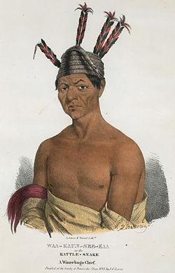
The first European-Americans to settle were the Day family from Tazewell County, Virginia. According to local Congregationalist minister Rev. Ephraim Adams, the Days arrived in June 1849 with the Ho-Chunks' "tents still standing—with the graves of the dead scattered about where now run our streets and stand our dwellings." [7] Judge Eliphalet Price suggested that the Days name their new settlement Decorah after Ho-Chunk leader Waukon Decorah, who was a U.S. ally during the Black Hawk War of 1832. [8]

Dunning's spring, 2018 Dunnings spring Decorah Iowa.jpg
Dunning's spring, 2018

During the 1850s and 1860s, Decorah grew quickly as settlers built dams and mills to harness water power at Dunning's Spring and other local streams. [9] In 1851, the town became the county seat of Winneshiek County. Decorah also became the site of a United States General Land Office from 1855 to 1856, making it a destination for immigrants seeking land patents in northern Iowa.

Since 1861, it has been the home of Luther College, a liberal arts institution affiliated with the Evangelical Lutheran Church in America.

The Milwaukee and St. Paul Railroad opened a branch to Decorah in 1869. [10]

Vesterheim Norwegian-American Museum Vesterheim2006.JPG
Vesterheim Norwegian-American Museum

Decorah has become a center for Norwegian-American culture originating from a high number of Norwegian settlements beginning in the 1850s. Each July, Decorah is the host of Nordic Fest, a celebration of Norwegian culture with ethnic dancing, food, and music. Decorah is also the home of the Vesterheim Norwegian-American Museum, the largest museum in the country devoted to a single immigrant group. Until 1972, one of the largest Norwegian language newspapers in the nation was published in Decorah, the Decorah Posten .

Geography

Decorah is located at 43°18′06″N91°47′25″W / 43.30167°N 91.79028°W / 43.30167; -91.79028 (43.301795, -91.790218), [11] approximately 15 miles (24 km) south of the Minnesota-Iowa border. It is the northernmost major community located along U.S. Route 52 in Iowa. According to the United States Census Bureau, the city has a total area of 7.04 square miles (18.23 km2), of which 7.01 square miles (18.16 km2) is land and 0.03 square miles (0.08 km2) is water. [12] The Upper Iowa River flows through the city en route to the Upper Mississippi River. The river is faced by steep bluffs, characteristic of the Driftless Area.

Impact crater

About 470 million years ago, a meteorite as big as a city block smashed into what is now Decorah, supporting a theory that a giant space rock broke up and bombarded Earth just as early life began flourishing in the oceans. [13]

The impact dug a crater nearly four miles wide that now lies beneath the town, said Bevan French, one of the world's foremost crater hunters and an adjunct scientist at the National Museum of Natural History. [13]

The Decorah crater lay undiscovered until recently because almost none of it is above ground. Instead, it is filled by an unusual shale that formed after an ancient seaway sluiced into the crater, depositing sediment and an array of bizarre sea creatures that hardened into fossils. [13] One such creature is Pentecopterus decorahensis , which was named for the city. [14]

Climate

Climate data for Decorah, Iowa (1991–2020 normals, extremes 1893–present)
MonthJanFebMarAprMayJunJulAugSepOctNovDecYear
Record high °F (°C)60
(16)
79
(26)
94
(34)
93
(34)
102
(39)
110
(43)
153
(67)
105
(41)
100
(38)
94
(34)
79
(26)
78
(26)
153
(67)
Mean maximum °F (°C)45.4
(7.4)
49.6
(9.8)
67.2
(19.6)
80.3
(26.8)
87.2
(30.7)
91.5
(33.1)
92.2
(33.4)
90.8
(32.7)
88.3
(31.3)
81.6
(27.6)
64.8
(18.2)
49.2
(9.6)
94.0
(34.4)
Mean daily maximum °F (°C)27.7
(−2.4)
32.8
(0.4)
46.2
(7.9)
61.3
(16.3)
72.5
(22.5)
81.4
(27.4)
84.4
(29.1)
82.7
(28.2)
76.4
(24.7)
63.2
(17.3)
46.6
(8.1)
32.9
(0.5)
59.0
(15.0)
Daily mean °F (°C)19.0
(−7.2)
23.4
(−4.8)
36.0
(2.2)
49.3
(9.6)
60.5
(15.8)
70.0
(21.1)
73.5
(23.1)
71.7
(22.1)
64.4
(18.0)
51.8
(11.0)
37.5
(3.1)
25.2
(−3.8)
48.5
(9.2)
Mean daily minimum °F (°C)10.4
(−12.0)
14.0
(−10.0)
25.9
(−3.4)
37.3
(2.9)
48.4
(9.1)
58.6
(14.8)
62.6
(17.0)
60.7
(15.9)
52.3
(11.3)
40.4
(4.7)
28.4
(−2.0)
17.4
(−8.1)
38.0
(3.3)
Mean minimum °F (°C)−18.2
(−27.9)
−12.3
(−24.6)
0.3
(−17.6)
19.7
(−6.8)
30.2
(−1.0)
42.3
(5.7)
48.8
(9.3)
46.8
(8.2)
34.0
(1.1)
21.8
(−5.7)
8.3
(−13.2)
−8.4
(−22.4)
−22.2
(−30.1)
Record low °F (°C)−53
(−47)
−45
(−43)
−36
(−38)
−15
(−26)
23
(−5)
31
(−1)
36
(2)
33
(1)
−7
(−22)
−21
(−29)
−35
(−37)
−44
(−42)
−53
(−47)
Average precipitation inches (mm)1.01
(26)
1.10
(28)
2.05
(52)
3.95
(100)
4.94
(125)
6.13
(156)
4.42
(112)
4.39
(112)
3.60
(91)
2.66
(68)
2.05
(52)
1.31
(33)
37.61
(955)
Average snowfall inches (cm)10.3
(26)
8.3
(21)
5.7
(14)
1.7
(4.3)
0.0
(0.0)
0.0
(0.0)
0.0
(0.0)
0.0
(0.0)
0.0
(0.0)
0.0
(0.0)
2.4
(6.1)
9.1
(23)
37.5
(95)
Average precipitation days (≥ 0.01 in)7.56.28.012.013.412.29.910.09.39.47.68.4113.9
Average snowy days (≥ 0.1 in)6.25.22.81.00.00.00.00.00.00.01.96.223.3
Source: NOAA [15] [16]

Demographics

Historical population
YearPop.±%
1860 1,920    
1870 2,110+9.9%
1880 2,951+39.9%
1890 2,801−5.1%
1900 3,246+15.9%
1910 3,592+10.7%
1920 4,039+12.4%
1930 4,581+13.4%
1940 5,303+15.8%
1950 6,060+14.3%
1960 6,435+6.2%
1970 7,237+12.5%
1980 8,068+11.5%
1990 8,063−0.1%
2000 8,172+1.4%
2010 8,127−0.6%
2020 7,587−6.6%
Source: "U.S. Census website". United States Census Bureau . Retrieved March 29, 2020.
Source:
U.S. Decennial Census [17] [5]
The population of Decorah, Iowa from US census data DecorahIowaPopPlot.png
The population of Decorah, Iowa from US census data

2020 census

As of the census of 2020, [18] the population was 7,587. The population density was 1,052.0 inhabitants per square mile (406.2/km2). There were 3,210 housing units at an average density of 445.1 per square mile (171.9/km2). The racial makeup of the city was 91.7% White, 1.8% Asian, 1.4% Black or African American, 0.3% Native American, 0.1% Pacific Islander, 1.5% from other races, and 3.1% from two or more races. Ethnically, the population was 3.6% Hispanic or Latino of any race.

The 2020 census population of the city included 1,463 people in student housing. [19]

According to the American Community Survey estimates for 2016-2020, the median income for a household in the city was $55,920, and the median income for a family was $85,822. Male full-time workers had a median income of $49,643 versus $43,991 for female workers. The per capita income for the city was $27,154. About 4.5% of families and 10.0% of the population were below the poverty line, including 11.0% of those under age 18 and 4.6% of those age 65 or over. [20] Of the population age 25 and over, 96.9% were high school graduates or higher and 43.8% had a bachelor's degree or higher. [21]

2010 census

As of the census [22] of 2010, there were 8,127 people, 2,855 households, and 1,527 families living in the city. The population density was 1,159.3 inhabitants per square mile (447.6/km2). There were 3,121 housing units at an average density of 445.2 per square mile (171.9/km2). The racial makeup of the city was 94.6% White, 1.5% African American, 2.2% Asian, 0.6% from other races, and 1.0% from two or more races. Hispanic or Latino of any race were 2.0% of the population.

There were 2,855 households, of which 21.9% had children under the age of 18 living with them, 44.4% were married couples living together, 6.8% had a female householder with no husband present, 2.3% had a male householder with no wife present, and 46.5% were non-families. 38.5% of all households were made up of individuals, and 18.7% had someone living alone who was 65 years of age or older. The average household size was 2.09 and the average family size was 2.76.

The median age in the city was 29.6 years. 14.3% of residents were under the age of 18; 32.1% were between the ages of 18 and 24; 15.3% were from 25 to 44; 19.5% were from 45 to 64; and 18.7% were 65 years of age or older. The gender makeup of the city was 46.1% male and 53.9% female.

2000 census

As of the census [23] of 2000, there were 8,172 people, 2,819 households, and 1,561 families living in the city. The population density was 1,275.9 inhabitants per square mile (492.6/km2). There were 2,968 housing units at an average density of 463.4 per square mile (178.9/km2). The racial makeup of the city was 95.99% White, 1.13% African American, 0.10% Native American, 1.60% Asian, 0.01% Pacific Islander, 0.42% from other races, and 0.76% from two or more races. Hispanic or Latino of any race were 1.30% of the population. 34.0% were of Norwegian, 30.3% German, 5.4% English and 5.2% Irish ancestry according to Census 2000.

There were 2,819 households, out of which 22.9% had children under the age of 18 living with them, 46.9% were married couples living together, 6.6% had a female householder with no husband present, and 44.6% were non-families. 37.1% of all households were made up of individuals, and 18.1% had someone living alone who was 65 years of age or older. The average household size was 2.13 and the average family size was 2.80.

The city's age demographics were spread out, with 15.0% under the age of 18, 31.4% from 18 to 24, 17.8% from 25 to 44, 17.0% from 45 to 64, and 18.8% who were 65 years of age or older. The median age was 30 years. For every 100 females, there were 81.6 males. For every 100 females age 18 and over, there were 78.5 males.

Economy

Winneshiek County Courthouse, which additionally holds the offices for the supervisors and county officers of Winneshiek County. 2009-0528-MN-IA13-Decorah-WinneshiekCourthouse.jpg
Winneshiek County Courthouse, which additionally holds the offices for the supervisors and county officers of Winneshiek County.

Decorah serves as the county seat of Winneshiek County, which is a major employer. The county courthouse was built in 1903. [24] Decorah's largest employer is Luther College, in addition to several national corporations. Because Winneshiek County's economy is primarily based on farming, Decorah serves as an agricultural hub. Decorah is also home to Seed Savers Exchange, an heirloom plant farm and preservation organization. [25]

Parks and recreation

Each July, Decorah hosts Nordic Fest, a celebration of Norwegian culture. Decorah is also the home of the Vesterheim Norwegian-American Museum, the largest Norwegian museum in the United States.

Natural features include Dunning's Spring, [26] Ice Cave, and Siewers Spring. The city is home to several parks built on bluffs, particularly Phelps Park, Palisades Park, and Pulpit Rock. Until 2003, Decorah had a community ski area, the Nor-Ski Runs Ski Area.

Decorah is home to an operating trout hatchery [27] as well as Twin Springs Park, the former home of the hatchery.

The Raptor Resource Project [28] is located in Decorah. Each year they host a livestreamed webcam of a family of nesting bald eagles as they rear their young.

Education

Decorah is part of the Decorah Community School District in Winneshiek County. [29] The high school is Decorah High School, and the mascot is the Vikings.

St. Benedict School of the Roman Catholic Archdiocese of Dubuque is in Decorah. It opened in 1885 in a two-story, four-room frame building. The school, with five nuns as teachers, was initially until high school but in 1919 became an elementary-middle school only. The convent, which had a second-floor bridge to the original school building, was renovated to be the second school building. In 1964 the current school was built for $268,000 in southern Decorah. A new addition was established in the 1980s, with a music room, a storage and teaching aid area, and two classrooms. [30]

Decorah is also home to Luther College, a private four-year residential college affiliated with the Evangelical Lutheran Church in America and known especially for their Nordic Choir. [31] Their mascot is "The Norse."

Media

Newspaper: The community newspaper is printed twice a week in Decorah - The Driftless Journal and Decorah Public Opinion. Newspaper office location: 110 Washington Street, Decorah, IA 52101.

Web: The local independent news web site is Decorah News. [32]

Radio

Historic Milwaukee Road Depot; it is now used as a chiropractic office. Historic photo seen here: 2009-0528-MN-IA16-Decorah-MilwaukeeRoadDepot.jpg
Historic Milwaukee Road Depot; it is now used as a chiropractic office. Historic photo seen here:

Other nearby stations include:

Notable people

Notes

Related Research Articles

<span class="mw-page-title-main">Wright County, Iowa</span> County in Iowa, United States

Wright County is a county in the U.S. state of Iowa. As of the 2020 census, the population was 12,943. The county seat is Clarion. The county organization became effective in January 1851, and is believed to be named either after Silas Wright, a governor of New York, or Joseph Albert Wright, a governor of Indiana.

<span class="mw-page-title-main">Winneshiek County, Iowa</span> County in Iowa, United States

Winneshiek County is a county located in the U.S. state of Iowa. As of the 2020 census, the population was 20,070. The county seat is Decorah.

<span class="mw-page-title-main">Hamilton County, Iowa</span> County in Iowa, United States

Hamilton County is a county located in the U.S. state of Iowa. As of the 2020 census, the population was 15,039. The county seat is Webster City. The county was named to honor William W. Hamilton, a President of the Iowa State Senate.

<span class="mw-page-title-main">Crawford County, Iowa</span> County in Iowa, United States

Crawford County is a county located in the U.S. state of Iowa. As of the 2020 census, the population was 16,525. Its county seat is Denison. The county was named for William Harris Crawford, U.S. senator from Georgia and United States Secretary of the Treasury.

<span class="mw-page-title-main">Benton County, Iowa</span> County in Iowa, United States

Benton County is a county in the U.S. state of Iowa. As of the 2020 census, the population was 25,575. Its county seat and largest city is Vinton. The county is named for Thomas Hart Benton, a U.S. Senator from Missouri.

<span class="mw-page-title-main">Postville, Iowa</span> Village in Iowa, United States

Postville is a village in Allamakee and Clayton counties in the U.S. state of Iowa. It lies near the junction of four counties and at the intersection of U.S. Routes 18 and 52 and Iowa Highway 51, with airport facilities in the neighboring communities of Waukon, Decorah, Monona and Prairie du Chien. The population was 2,503 at the time of the 2020 census, up from 2,273 in 2000. The village is in Allamakee County's southwestern corner and the Clayton County's northwestern corner in a quad county, or four-corner region, where four counties intersect. Winneshiek County is just to the west and Fayette County just to the southwest of Postville.

<span class="mw-page-title-main">Waukon, Iowa</span> City in Iowa, United States

Waukon is a city in Makee Township, Allamakee County, Iowa, United States, and the county seat of Allamakee County. The population was 3,827 at the time of the 2020 census.

<span class="mw-page-title-main">Logan, Iowa</span> City in Iowa, United States

Logan is a city and county seat of Harrison County, Iowa, United States, along the Boyer River. The population was 1,397 at the time of the 2020 census.

<span class="mw-page-title-main">Chester, Iowa</span> City in Iowa, United States

Chester is a city in Howard County, Iowa, United States. The population was 139 in the 2020 census, a decrease of 7.9% from the 151 population in the 2000 census. Chester is located close to the state line from Minnesota.

<span class="mw-page-title-main">Elma, Iowa</span> City in Iowa, United States

Elma is a city in Howard County, Iowa, United States. The population was 505 at the time of the 2020 census.

<span class="mw-page-title-main">Lime Springs, Iowa</span> City in Iowa, United States

Lime Springs is a city in Howard County, Iowa, United States. The population was 473 at the time of the 2020 census.

<span class="mw-page-title-main">Ida Grove, Iowa</span> City in Iowa, United States

Ida Grove is a city in Ida County, Iowa, United States. The population was 2,051 at the time of the 2020 census. It is the county seat of Ida County.

<span class="mw-page-title-main">Calmar, Iowa</span> City in Iowa, United States

Calmar is a city in Winneshiek County, Iowa, United States. The population was 1,125 at the 2020 census. It is at the junction of U.S. Route 52 and State highways 150 and 24, with both state routes terminating in Calmar.

<span class="mw-page-title-main">Castalia, Iowa</span> City in Iowa, United States

Castalia is a city in Winneshiek County, Iowa, United States. The population was 145 at the 2020 census.

<span class="mw-page-title-main">Fort Atkinson, Iowa</span> City in Iowa, United States

Fort Atkinson is a city in Winneshiek County, Iowa, United States. The population was 312 at the time of the 2020 census. It is home to the historic Fort Atkinson State Preserve and hosts a large annual fur-trapper rendezvous each September. Fort Atkinson holds the largest regional hay auction every Wednesday.

<span class="mw-page-title-main">Ossian, Iowa</span> City in Iowa, United States

Ossian (pronounced|ˈosh-ain) is a city in Winneshiek County, Iowa, United States. The population was 802 at the time of the 2020 census.

<span class="mw-page-title-main">Ridgeway, Iowa</span> City in Iowa, United States

Ridgeway is a city in Winneshiek County, Iowa, United States. The population was 275 at the time of the 2020 census.

<span class="mw-page-title-main">Spillville, Iowa</span> City in Iowa, United States

Spillville is a city in Winneshiek County, Iowa, United States. The population was 385 at the time of the 2020 census. It is located in Calmar Township, approximately 4 mi (6.4 km) west of Calmar and about 12 miles (19 km) southwest of Decorah, the county seat. Spillville is known for its Independence Day fireworks display, held the first Saturday in July.

<span class="mw-page-title-main">Burr Oak, Iowa</span> CDP in Iowa, United States

Burr Oak is an unincorporated community in Winneshiek County, Iowa, United States, very close to the Minnesota state line. Burr Oak is a census-designated place and the population was 166 in the 2010 census.

The North Winneshiek Community School District was a public school district in unincorporated northern Winneshiek County, Iowa, with a Decorah address. At the end of the district's existence, it only served grades Pre-K through 6th. The enrollment count for the 2015–2016 school year was 126 students.

References

  1. "Meet Decorah's new mayor". Luther Magazine. Retrieved November 8, 2020.
  2. "2020 U.S. Gazetteer Files". United States Census Bureau. Retrieved March 16, 2022.
  3. Sherman, Barney (September 14, 2017). "Iowa Place Names: A-E". Iowa Public Radio. Retrieved June 16, 2021.
  4. "Find a County". National Association of Counties. Archived from the original on May 31, 2011. Retrieved June 7, 2011.
  5. 1 2 "2020 Census State Redistricting Data". census.gov. United states Census Bureau. Retrieved August 12, 2021.
  6. Whittaker, William E. (March 10, 2016). "An Analysis of Historic-Era Indian Locations in Iowa". Midcontinental Journal of Archaeology. 41 (2): 159–185. doi:10.1080/01461109.2016.1156799. S2CID   163755581.
  7. Sparks, Charles H. (1877). History of Winneshiek County, with Biographical Sketches of its Eminent Men. Decorah, Ia: Jas. Alex. Leonard. p.  87.
  8. Alexander, W.E. (1882). History of Winneshiek and Allamakee Counties Iowa. Sioux City, Ia.: Western Publishing Co. pp.  141–142, 269.
  9. Faldet, David S. (2009). Oneota Flow: the Upper Iowa River and its people. Iowa City: University of Iowa Press. pp. 104–105. ISBN   9781587298363.
  10. Alexander (1882), pp. 190-191, 249, 271-272.
  11. "US Gazetteer files: 2010, 2000, and 1990". United States Census Bureau. February 12, 2011. Retrieved April 23, 2011.
  12. "US Gazetteer files 2010". United States Census Bureau. Archived from the original on January 25, 2012. Retrieved May 11, 2012.
  13. 1 2 3 Vastag, Brian (February 18, 2013). "Crater found in Iowa points to asteroid break-up 470 million years ago". The Washington Post.
  14. Lamsdell, James C.; Briggs, Derek E. G.; Liu, Huaibao; Witzke, Brian J.; McKay, Robert M. (September 1, 2015). "The oldest described eurypterid: a giant Middle Ordovician (Darriwilian) megalograptid from the Winneshiek Lagerstätte of Iowa". BMC Evolutionary Biology . 15: 169. doi: 10.1186/s12862-015-0443-9 . PMC   4556007 . PMID   26324341.
  15. "NowData – NOAA Online Weather Data". National Oceanic and Atmospheric Administration. Retrieved June 25, 2021.
  16. "Station: Decorah, IA". U.S. Climate Normals 2020: U.S. Monthly Climate Normals (1991–2020). National Oceanic and Atmospheric Administration. Retrieved June 25, 2021.
  17. "Census of Population and Housing". Census.gov. Retrieved June 4, 2015.
  18. "2020 Decennial Census: Decorah city, Iowa". data.census.gov. U.S. Census Bureau. Retrieved July 4, 2022.
  19. "Group Quarters Population, 2020 Census: Decorah city, Iowa". data.census.gov. U.S. Census Bureau. Retrieved December 21, 2022.
  20. "Selected Economic Characteristics, 2020 American Community Survey: Decorah city, Iowa". data.census.gov. U.S. Census Bureau. Retrieved December 21, 2022.
  21. "Selected Social Characteristics, 2020 American Community Survey: Decorah city, Iowa". data.census.gov. U.S. Census Bureau. Retrieved December 21, 2022.
  22. "U.S. Census website". United States Census Bureau . Retrieved May 11, 2012.
  23. "U.S. Census website". United States Census Bureau . Retrieved January 31, 2008.
  24. Ms.Hegstrom (January 8, 2009). "Iowa Courthouses". iowacourthouses.blogspot.com. Retrieved January 27, 2016.
  25. "Seed Savers Exchange - Saving America's Heirloom Seeds". seedsavers.org. Retrieved January 27, 2016.
  26. "Environmental Studies". luther.edu. Retrieved January 27, 2016.
  27. "Decorah Fish Hatchery". iowadnr.gov. Archived from the original on June 21, 2012. Retrieved January 27, 2016.
  28. Raptor Resource Center
  29. "Home - Decorah Community School District". decorah.k12.ia.us. Retrieved January 27, 2016.
  30. "History of St. Benedict School". St. Benedict School. October 28, 2003. Archived from the original on October 28, 2003. Retrieved April 7, 2020.
  31. "Luther College". luther.edu. Retrieved January 27, 2016.
  32. "Decorah news NOW! Local news, weather, sports & information". decorahnews.com. Retrieved August 1, 2018.
  33. Schwieterman, Joseph P. (2004). When the Railroad Leaves Town: American Communities in the Age of Rail Line Abandonment, Western United States. Kirksville, Missouri: Truman State University Press. pp. 136–139. ISBN   978-1-931112-13-0.