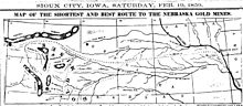
1859 map of route from Sioux City, Iowa, through Nebraska, to gold fields of Wyoming, partially following old Mormon trails.
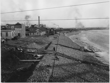
Sioux City was laid out in the winter of 1854–1855.[5] It became a major transportation hub to the western Plains, including Mormons heading to Salt Lake City and speculators heading to Wyoming goldfields.
In 1891, the Sioux City Elevated Railway was opened and became the third steam-powered elevated rapid transit system in the world, and later the first electric-powered elevated railway in the world after conversion in 1892. However, the system fell into bankruptcy and closed within a decade.[6]
The city gained the nickname "Little Chicago" during the Prohibition era due to its reputation for being a purveyor of alcoholic beverages.[7]
On July 19, 1989, United Airlines Flight 232 crash-landed at Sioux Gateway Airport, killing 112 people, but 184 survived the crash and ensuing fire due to outstandingly quick performances by fire and emergency local teams.[8][9]
According to a 2015 University of Iowa study for the Iowa Initiative for Sustainable Communities,[10] blight and disinvestment are serious problems in the downtown core as investment has shifted to suburbs.[11]
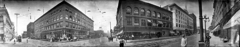
Sioux City, 1911
Geography
Sioux City borders two states, South Dakota to the west-northwest and Nebraska to the west.
According to the United States Census Bureau, the city has a total area of 59.63sqmi (154.44km2), of which 58.46sqmi (151.41km2) is land and 1.165sqmi (3.02km2) is water.[1]
As is typical of Iowa, Sioux City has a humid continental climate, with very warm, humid summers, cold, dry winters, and wide temperature extremes; it is part of USDA Hardiness zone 5a.[12] The normal monthly mean temperature ranges from 20.0°F (−6.7°C) in January to 74.2°F (23.4°C) in July. On average, there are 25 days that reach 90°F (32°C) or higher, 52 days that do not climb above freezing, and 17 days with a low of 0°F (−18°C) or below annually. The average window for freezing temperatures is October 1 through April 26, allowing a growing season of 157 days. Extreme temperatures officially range from −35°F (−37°C) on 12 January 1912 up to 111°F (44°C) on 4 July 1936 and 17 July 1936, as well as 11 July 1939; the record cold daily maximum is −22°F (−30°C) on 8 February 1899, while, conversely, the record warm daily minimum is 86°F (30°C) on 18 August 1936.
Precipitation is greatest in May and June and averages 29.27in (743mm) annually, but has ranged from 14.33in (364mm) in 1976 to 41.10in (1,044mm) in 1903. Snowfall averages 36.0in (91cm) per season, and has historically ranged from 6.9in (18cm) in 1895–1896 to 65.9in (167cm) in 1961–1962; the average window for measurable (≥0.1in or 0.25cm) snowfall is November 8 through April 7, although snow in October occurs several times per decade. On 14 May 2013, the high temperature reached 106°F (41°C), setting a new all-time May record high, along with a 77°F (43°C) rise from the morning of the 12th.[13]
Climate data for Sioux City, Iowa (Sioux Gateway Airport), 1991–2020 normals, extremes 1889–present
Sioux City, Iowa – Racial and ethnic composition Note: the US Census treats Hispanic/Latino as an ethnic category. This table excludes Latinos from the racial categories and assigns them to a separate category. Hispanics/Latinos may be of any race.
As of the census of 2020, there were 85,797 people. The racial makeup of the city was 76.3% White, 4.8% African American, 2.2% Native American, 2.9% Asian, 0.6% Pacific Islander, and 10.1% from other races or from two or more races. Hispanic or Latino of any race were 20.9% of the population.[21] The city has significant minority populations of West Africans, Somalis, Ethiopians, Vietnamese, Mexicans, and Guatemalans. This has been attributed to the many meat factories and manufacturing jobs in the area.
2010 census
As of the census[22] of 2010, there were 82,684 people, 31,571 households, and 20,144 families residing in the city. The population density was 1,441.7/sqmi (556.6/km2). There were 33,425 housing units at an average density of 582.8/sqmi (225.0/km2). The racial makeup of the city was 80.6% White, 2.9% African American, 2.6% Native American, 2.7% Asian, 0.1% Pacific Islander, 7.4% from other races, and 3.7% from two or more races. Hispanic or Latino of any race were 16.4% of the population.
There were 31,571 households, of which 34.3% had children under the age of 18 living with them, 44.2% were married couples living together, 13.8% had a female householder with no husband present, 5.9% had a male householder with no wife present, and 36.2% were non-families. 29.4% of all households were made up of individuals, and 11.1% had someone living alone who was 65 years of age or older. The average household size was 2.54 and the average family size was 3.14.
The median age in the city was 33.7 years. 26.6% of residents were under the age of 18; 11.4% were between the ages of 18 and 24; 25.6% were from 25 to 44; 24% were from 45 to 64, and 12.4% were 65 years of age or older. The gender makeup of the city was 49.2% male and 50.8% female.
2000 census
As of the census of 2000, there were 85,013 people, 32,054 households, and 21,091 families residing in the city. The population density was 1,551.3 inhabitants per square mile (599.0/km2). There were 33,816 housing units at an average density of 617.1 per square mile (238.3/km2). The racial makeup of the city was 85.23% White, 2.41% African American, 1.95% Native American, 2.82% Asian, 0.04% Pacific Islander, 5.27% from other races, and 2.28% from two or more races. Hispanic or Latino of any race were 10.89% of the population.
There were 32,054 households, of which 33.4% had children under the age of 18 living with them, 49.1% were married couples living together, 12.2% had a female householder with no husband present, and 34.2% were non-families. 27.7% of all households were made up of individuals, and 11.3% had someone living alone who was 65 years of age or older. The average household size was 2.57 and the average family size was 3.14.
Age spread: 27.1% under the age of 18, 11.0% from 18 to 24, 28.5% from 25 to 44, 20.2% from 45 to 64, and 13.3% who were 65 years of age or older. The median age was 33 years. For every 100 females, there were 95.4 males. For every 100 females age 18 and over, there were 92.2 males.
The median income for a household in the city was US$37,429, and the median income for a family was US$45,751. Males had a median income of US$31,385 versus US$22,470 for females. The per capita income for the city was US$18,666. About 7.9% of families and 11.2% of the population were below the poverty line, including 15.0% of those under age 18 and 7.8% of those age 65 or over. This compares with a median household income for the state of Iowa of US$54,736 and an Iowa median family income of US$69,382.[23] (current data from State of Iowa, see also List of U.S. states by income for historical data).
Metropolitan area
As of the 2020 census, the Sioux City Metropolitan Area had 149,940 residents in four counties. As defined by the Office of Management and Budget, the counties comprising the metropolitan area are (in descending order of population):
Sioux City has a crime rate that is 91% higher than the average for Iowa and 63% higher than the national average. The violent crime rate is 90% above the Iowa average and 49% higher than the national average, based on the FBI's uniform crime reports for 2020.[24] According to the report, this represented a 12% decrease over the prior year.
The Sioux City Public Museum was originally located in a Northside neighborhood of fine Victorian mansions. The portico-and-gabled stone building was originally the home of the banker, John Peirce, and was built in 1890. The museum was recently relocated to downtown Sioux City, where it features Native American, pioneer, early Sioux City, and natural history exhibits.
Chris Larsen Park, informally known as "The Riverfront," includes the Anderson Dance Pavilion, the Sergeant Floyd Riverboat Museum and the Lewis and Clark Interpretive Center, opened in 2004. Missouri River development began in 2005 with the opening of the MLR Tyme Marina area, which included Bev's on the River, an upscale restaurant, that has now become a Crave.[27]
The Sioux City Symphony Orchestra (SCSO) was founded in 1915. The orchestra continues offering seven concerts within its annual season. Performances take place in the Orpheum Theatre in Sioux City, Iowa. Concert dates run from September to April each year. The SCSO has included several movie scores, with film, on its concert schedule. The SCSO's education programming reaches 9,000 to 12,000 young people via the partnership with Carnegie Hall's Link Up program with 100 orchestras in the country, programs for SCSO musicians to perform and teach music lessons in the schools, and performances in nursing homes, hospitals, and elsewhere.[citation needed]
Milwaukee Railroad Shop is a 31.5 acres (12.7ha) facility that is being renovated by the Siouxland Historical Railroad Association. It includes a 4-6-2 Pacific type steam locomotive, the Great Northern 1355, a model railroad exhibit, as well as multiple buildings including the roundhouse that are open to the public.
Grandview Park is located north of the downtown area, up from Rose Hill, between The Northside and The Heights. The Municipal Bandshell is located in the park with Sunday evening municipal band concerts. The Saturday in the Park music festival began in 1991 and is held there annually on a weekend close to the Fourth of July holiday. Behind the bandshell is a rose garden with an arbor and trellises which has been a site for outdoor weddings, prom and other special occasion photographs, and for children to play during the Sunday evening band concerts and other events. Downtown is also home to the historic Orpheum Theatre. In 1927 when it was built, it was the largest theater in Iowa.[28]
Theatre is produced in Sioux City by three main entities, the Sioux City Community Theatre (SCCT), LAMB Arts Regional Theatre, and Shot in the Dark Productions. Each of these produce a full season of shows each year.
The Sioux City Musketeers are a junior hockey team based in Sioux City. They play in the United States Hockey League (USHL). They play their home games at the Tyson Events Center. Their first year of hockey was in 1972. The Musketeers have won the gold cup in the 1985-1986 season, the National Runner-up twice (1993–94, 1995–96), the Anderson Cup three times (1981–82, 1985–86, 2016–17), the Clark Cup four times (1981–82, 1985–86, 2001–02, 2021- 22 ), and Western Division Champions for the 2004–05, and 2016-17 seasons.
Stone State Park is in the northwest corner of the city, overlooking the South Dakota/Iowa border. Stone Park is near the northernmost extent of the Loess Hills, and is at the transition from clay bluffs and prairie to sedimentary rock hills and bur oak forest along the Iowa side of the Big Sioux River. The park is used by picnickers, day hikers, and for mountain biking.
Dorothy Pecaut Nature Center is a destination nature preserve for Woodbury County, and is located within the boundaries of Stone State Park. The butterfly garden is unique to the area; wild turkeys and white-tail deer are commonly sighted from the well-marked trails.
Downtown entertainment venues include the Hard Rock Hotel & Casino, the 10,000-seat Tyson Events Center/ Fleet Farm Arena, Sioux City Orpheum Theatre, Promenade Cinema 14 and the Anderson Dance Pavilion which overlooks the Missouri River.
Pulaski Park is named for the Polish General Kazimierz Pułaski, who fought in the American Revolution. This park features baseball diamond facilities, and is located in western Morningside along old U.S. Highway 75 (South Lewis Blvd.). It is largely built on the filled lakebed of Half Moon Lake, which was originally created in the 1890s by the excavation of fill dirt to build the approaches for the iron railroad bridge spanning the Missouri near the stockyards. The neighborhood on the bluff overlooking the park was historically settled by Lithuanian and Polish immigrants, many of whom worked in the meatpacking industry during the early 20th century.[citation needed]
Latham Park is located in a residential area of Morningside, and is the only privately owned and maintained open-to-the-public park within the city limits.[citation needed] It was left in trust in 1937 under the terms of Clara Latham's will; her family had built the house on 1-acre (4,000m2) of ground in 1915. The house and grounds are currently being restored by the Friends of Latham Park.
First Bride's Grave is tucked in a corner pocket of South Ravine Park, lies a series of paths, trails, and steps leading to the grave of the First Bride of Sioux City, Rosalie Menard. She was the first bride of a non-Native American to be wed in Sioux City, Iowa, thus receiving her title.
War Eagle Park is named for the Yankton Sioux chief Wambdi Okicize (d.1851) who befriended early settlers. A monument overlooks the confluence of the Big Sioux and Missouri Rivers. The sculpture represents the chief in his role as a leader and peacemaker, wearing the eagle feather bonnet and holding the ceremonial pipe.
Riverside Park is located on the banks of the Big Sioux River. One of the oldest recreational areas of the city, it is home to the Sioux City Boat Club and Sioux City Community Theater. The park is on land that once belonged to the first white settler in the area, Théophile Bruguier; his original cabin is preserved in the park.[31]
Bacon Creek Park is located northeast of Morningside and features a scenic walking trail, dog park, picnic shelters, and playground equipment.
Golf courses, city parks, and aquatics: Sioux City is also home to several municipal public golf courses, including Floyd Park in Morningside, Green Valley near the Southern Hills, Sun Valley on the northern West Side, and Hidden Acres in nearby Plymouth County. Sioux City also has a number of private golf clubs, including Sioux City Country Club, and Whispering Creek Golf Club. The city has over 1,132 acres (5km2) of public parkland located at 53 locations, including the riverfront and many miles of recreation trails. Five public swimming pools/aquatics centers are located within Sioux City neighborhoods.
Sioux City Transit, the local public transit organization, operates several bus lines within the city. Buses transfer downtown in the Martin Luther King Jr. Transportation Center at 505 Nebraska Street.[35] The Sioux City Paratransit serves members of the community who would otherwise not be able to travel by providing door to door service.[36]
Air
The city is served by Sioux Gateway Airport (SUX) 6mi (9.7km) to its south where United Airlines' affiliate SkyWest Airlines has announced it plans to discontinue the one flight per day each to Chicago and Denver it currently offers. As those flights are federally subsidized under the Essential Air Service program, SkyWest is required to continue those flights until a replacement is found.[37]
FBO and jet charter services are currently offered by Hawthorne Global Aviation Services.[38]
Sioux City also has several private taxi companies that operate within the city.
There is no established water or rail passenger transportation in the area. The last passenger train was the Illinois Central's Hawkeye, a daily train to Chicago via Waterloo, Dubuque and Rockford, discontinued in 1971.[39]
John W. Aldridge, born in Sioux City, grew up in Tennessee, literary critic, author
Jim Aton, jazz bassist, pianist, vocalist and composer with Billie Holiday, Bill Evans, Anita O'Day, others
Art Babbitt (1907–1992), an American animator, best known for his work at Walt Disney Animation Studios. He received over 80 awards as an animation director and animator, and also developed the character of Goofy. Graduated from Central High in 1924.
Brigadier General George E. "Bud" Day, U.S. Air Force, Vietnam POW, recipient of the Medal of Honor; the United States' most highly decorated officer since General Douglas MacArthur; Sioux City's airport is named Brigadier General Bud Day Field in his honor, as is 6th Street (Honorable Bud Day Street)
Leo Delperdang, born in Sioux City. Member of Kansas House of Representatives
W. Edwards Deming, quality-control expert, helped improve Japan's quality control
Esther and Pauline Friedman, better known as Ann Landers and Abigail Van Buren, respectively; advice columnists; both born in Sioux City and graduates of Central High School
Dan Goldie, tennis player, winner of two ATP singles titles
Fred Grandy, television actor who played Gopher Smith on The Love Boat; later became a U.S. congressman, CEO of Goodwill, and a radio personality for WMAL in Washington, D.C.
Morgan Taylor, athlete, set 400-meter hurdles Olympic record while winning gold medal in 1924, also NCAA champion, 1928 and 1932 Olympic bronze medalist
↑ "Station: Sioux City Gateway AP, IA". U.S. Climate Normals 2020: U.S. Monthly Climate Normals (1991–2020). National Oceanic and Atmospheric Administration. Retrieved 2021-06-27.
This page is based on this Wikipedia article Text is available under the CC BY-SA 4.0 license; additional terms may apply. Images, videos and audio are available under their respective licenses.