Chickasaw County, Iowa

Last updated

Chickasaw County
2009-0528-NewHampton-ChickasawCtycourthouse.jpg
Chickasaw County court house built in 1929
Map of Iowa highlighting Chickasaw County.svg
Location within the U.S. state of Iowa
Iowa in United States.svg
Iowa's location within the U.S.
Coordinates: 43°03′36″N92°19′08″W / 43.06°N 92.318888888889°W / 43.06; -92.318888888889
CountryFlag of the United States.svg United States
StateFlag of Iowa.svg  Iowa
FoundedJanuary 15, 1851
Named for Chickasaw people
Seat New Hampton
Largest cityNew Hampton
Area
  Total506 sq mi (1,310 km2)
  Land504 sq mi (1,310 km2)
  Water1.3 sq mi (3 km2)  0.3%
Population
 (2020)
  Total12,012
  Density24/sq mi (9.2/km2)
Time zone UTC−6 (Central)
  Summer (DST) UTC−5 (CDT)
Congressional district 2nd
Website chickasawcounty.iowa.gov

Chickasaw County is a county located in the U.S. state of Iowa. As of the 2020 census, the population was 12,012. [1] Its county seat is New Hampton. [2] The county was named for the southern Indian Nation whose chief was Bradford.

Contents

History

Chickasaw County was founded in January 1851. It was named after the Chickasaw tribe, which lived in the Southern United States at the time.

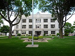
The first nonindigenous settlers arrived in 1848 and the first county seat was from 1854 in Bradford, in the southwestern corner of the county. In the spring of 1857, the seat was moved to New Hampton, located near the geographic center, and was then called Chickasaw Center. The first county offices were housed in private houses and in the school building. The first courthouse, a wood-frame building, was erected in 1865. That building was enlarged in 1876, but a fire on March 26, 1880, destroyed it (townspeople managed to save the records). [3] A brick/stone replacement structure was completed in 1881, and included a soaring clock tower. This building was enlarged in 1905 and again in 1906, but by the twenties it again was too small. The present structure, featuring Bedford stone, was built in 1929 and put into use in 1930.

Geography

According to the US Census Bureau, the county has a total area of 506 square miles (1,310 km2), of which 504 square miles (1,310 km2) is land and 1.3 square miles (3.4 km2) (0.3%) is water. [4]

Adjacent counties

Highways

Demographics

Historical population
CensusPop.Note
1860 4,336
1870 10,180134.8%
1880 14,53442.8%
1890 15,0193.3%
1900 17,03713.4%
1910 15,375−9.8%
1920 15,4310.4%
1930 14,637−5.1%
1940 15,2274.0%
1950 15,2280.0%
1960 15,034−1.3%
1970 14,969−0.4%
1980 15,4373.1%
1990 13,295−13.9%
2000 13,095−1.5%
2010 12,439−5.0%
2020 12,012−3.4%
2023 (est.)11,658 [5] −2.9%
U.S. Decennial Census [6]
1790-1960 [7] 1900-1990 [8]
1990-2000 [9] 2010-2018 [10]
Population of Chickasaw County from US census data ChickasawCountyIowaPop2020.png
Population of Chickasaw County from US census data

2020 census

2022 US Census population pyramid for Chickasaw County from ACS 5-year estimates ChickasawCountyIA2022PopPyr.png
2022 US Census population pyramid for Chickasaw County from ACS 5-year estimates

The 2020 census recorded a population of 12,012 in the county, with a population density of

2010 census

The 2010 census recorded a population of 12,439 in the county, with a population density of

2000 census

As of the census [12] of 2000, there were 13,095 people, 5,192 households, and 3,644 families residing in the county. The population density was 26 people per square mile (10 people/km2). There were 5,593 housing units at an average density of 11 units per square mile (4.2 units/km2). The racial makeup of the county was 98.75% White, 0.05% Black or African American, 0.03% Native American, 0.27% Asian, 0.01% Pacific Islander, 0.29% from other races, and 0.60% from two or more races. 0.63% of the population were Hispanic or Latino of any race.

There were 5,192 households, out of which 31.90% had children under the age of 18 living with them, 60.70% were married couples living together, 6.30% had a female householder with no husband present, and 29.80% were non-families. 26.10% of all households were made up of individuals, and 13.70% had someone living alone who was 65 years of age or older. The average household size was 2.48 and the average family size was 3.00.

In the county, the population was spread out, with 26.10% under the age of 18, 6.90% from 18 to 24, 25.60% from 25 to 44, 23.40% from 45 to 64, and 17.90% who were 65 years of age or older. The median age was 40 years. For every 100 females there were 100.10 males. For every 100 females age 18 and over, there were 96.50 males.

The median income for a household in the county was $37,649, and the median income for a family was $44,306. Males had a median income of $30,099 versus $21,309 for females. The per capita income for the county was $18,237. About 5.90% of families and 8.30% of the population were below the poverty line, including 9.90% of those under age 18 and 7.70% of those age 65 or over.

Chickasaw County posted the highest county unemployment rate in Iowa in the 2000 Census with 8% of the workforce unemployed. This figure, however, was still relatively low compared to the problems faced by many other counties in the Midwest.

Communities

Cities

Unincorporated communities

Townships

Population ranking

The population ranking of the following table is based on the 2020 census of Chickasaw County. [1]

county seat

RankCity/Town/etc.Municipal typePopulation (2020 Census)
1 New Hampton City3,494
2 Nashua (partially in Floyd County )City1,551
3 Fredericksburg City987
4 Lawler City406
5 Ionia City226
6 Protivin (mostly in Howard County )City269
7 Alta Vista City227
8 North Washington City112
9 Bassett City45

Politics

Chickasaw County was a bellwether county from 1948 to 1984, voting for the nationwide winner in every election in that span. From 1988 to 2012, the county favored Democrats, as the Democratic nominee won the county by at least 10% in each election in that span except for 2000. Then, in 2016, Chickasaw County swung significantly to the right, shifting from Barack Obama winning the county by 11% in 2012 to Donald Trump winning by 23% in 2016, a shift of 34% to the right. Trump won over 58% of the county's vote, turning in the best performance for a Republican since the 1952 landslide election of Dwight D. Eisenhower. Trump further improved on this performance in 2020, taking nearly 65% of the vote and winning by a margin of over 31%, the best vote share and margin of victory for any candidate in Chickasaw County since the 1932 landslide election of Franklin D. Roosevelt.

United States presidential election results for Chickasaw County, Iowa [14]
Year Republican Democratic Third party
No.%No.%No.%
2020 4,30864.97%2,23333.68%901.36%
2016 3,74258.15%2,26635.21%4276.64%
2012 2,83643.74%3,55454.81%941.45%
2008 2,55738.82%3,92359.57%1061.61%
2004 3,04044.67%3,70854.48%580.85%
2000 2,93644.59%3,43552.17%2133.24%
1996 2,19134.45%3,35552.75%81412.80%
1992 2,12932.06%2,91343.87%1,59824.07%
1988 2,54941.54%3,53057.53%570.93%
1984 3,66152.93%3,18646.06%701.01%
1980 3,92952.86%2,93539.49%5697.66%
1976 3,43249.11%3,50350.13%530.76%
1972 3,83654.57%3,13444.58%600.85%
1968 3,51051.89%2,96643.85%2884.26%
1964 2,63236.65%4,54563.28%50.07%
1960 3,82248.45%4,06351.50%40.05%
1956 4,20556.10%3,27543.70%150.20%
1952 5,02263.18%2,92136.75%60.08%
1948 3,44945.45%4,07153.64%690.91%
1944 3,57551.59%3,32848.03%260.38%
1940 4,44052.71%3,98147.26%20.02%
1936 3,14339.96%4,45856.67%2653.37%
1932 2,58533.68%5,04765.75%440.57%
1928 3,71250.20%3,66549.57%170.23%
1924 3,41646.50%1,73623.63%2,19529.88%
1920 4,51766.98%2,17132.19%560.83%
1916 1,99953.61%1,69745.51%330.88%
1912 1,02228.15%1,89152.08%71819.77%
1908 1,57144.87%1,87753.61%531.51%
1904 1,97251.74%1,79046.97%491.29%
1900 2,08549.71%2,06349.19%461.10%
1896 1,96748.20%2,08451.07%300.74%

See also

Related Research Articles

<span class="mw-page-title-main">Montgomery County, Iowa</span> County in Iowa, United States

Montgomery County is a county located in the southwestern area of the U.S. state of Iowa. As of the 2020 census, the population was 10,330. Its population has declined since a peak in 1900, since urbanization and decline of family farms. The county seat is Red Oak. The county was founded by European-American migrants from eastern areas in 1851. It was named in honor of Richard Montgomery, an American Revolutionary War general killed in 1775 while trying to capture Quebec City, Canada.

<span class="mw-page-title-main">Black Hawk County, Iowa</span> County in Iowa, United States

Black Hawk County is a county in the northeastern part of U.S. state of Iowa. As of the 2020 census, the population was 131,144, making it Iowa's fifth-most populous county. The county seat is Waterloo.

<span class="mw-page-title-main">Chickasaw County, Mississippi</span> County in Mississippi, United States

Chickasaw County is a county located in the U.S. state of Mississippi. As of the 2020 census, the population was 17,106. Its county seats are Houston and Okolona. The county is named for the Chickasaw people, who lived in this area for hundreds of years. Most were forcibly removed to Indian Territory in the 1830s, but some remained and became citizens of the state and the United States.

<span class="mw-page-title-main">Wapello County, Iowa</span> County in Iowa, United States

Wapello County is a county located in the U.S. state of Iowa. As of the 2020 census, the population was 35,437. The county seat is Ottumwa. The county was formed on February 17, 1843, and named for Wapello, a Meskwaki chief.

<span class="mw-page-title-main">Ringgold County, Iowa</span> County in Iowa, United States

Ringgold County is a county located in the U.S. state of Iowa. As of the 2020 census, the population was 4,663, making it the Iowa county with the second-smallest population. The county seat is Mount Ayr. The county is named after Maj. Samuel Ringgold, a hero of the Battle of Palo Alto fought in May 1846, during the Mexican–American War. It is one of the 26 Iowa counties with a name that is unique across the nation.

<span class="mw-page-title-main">Mahaska County, Iowa</span> County in Iowa, United States

Mahaska County is a county located in the U.S. state of Iowa. As of the 2020 census, the population was 22,190. The county seat is Oskaloosa.

<span class="mw-page-title-main">Hancock County, Iowa</span> County in Iowa, United States

Hancock County is a county in the U.S. state of Iowa. As of the 2020 census, the population was 10,795. The county seat is Garner. The county was founded on January 15, 1851, and named in honor of John Hancock, a leader of the Continental Congress during the American Revolution.

<span class="mw-page-title-main">Franklin County, Iowa</span> County in Iowa, United States

Franklin County is a county located in the U.S. state of Iowa. As of the 2020 census, the population was 10,019. The county seat is Hampton. The county was formed on January 15, 1851 and named after Benjamin Franklin.

<span class="mw-page-title-main">Floyd County, Iowa</span> County in Iowa, United States

Floyd County is a county located in the U.S. state of Iowa. As of the 2020 census, the population was 15,627. The county seat is Charles City.

<span class="mw-page-title-main">Fayette County, Iowa</span> County in Iowa, United States

Fayette County is a county located in the U.S. state of Iowa. As of the 2020 census, the population was 19,509. The county seat is West Union.

<span class="mw-page-title-main">Dickinson County, Iowa</span> County in Iowa, United States

Dickinson County is a county located in the U.S. state of Iowa. As of the 2020 census, the population was 17,703. The county seat is Spirit Lake. The county was organized in 1857 and is named in honor of Daniel S. Dickinson, a U.S. Senator for New York.

<span class="mw-page-title-main">Delaware County, Iowa</span> County in Iowa, United States

Delaware County is a county located in the U.S. state of Iowa. As of the 2020 census, the population was 17,488. The county seat is Manchester. The county takes its name after the U.S. state of Delaware.

<span class="mw-page-title-main">Davis County, Iowa</span> County in Iowa, United States

Davis County is a county located in the U.S. state of Iowa. As of the 2020 census, the population was 9,110. The county seat is Bloomfield.

<span class="mw-page-title-main">Butler County, Iowa</span> County in Iowa, United States

Butler County is a county located in the U.S. state of Iowa. As of the 2020 census, the population was 14,334. Its county seat is Allison. The county was organized in 1854 and named for General William O. Butler.

<span class="mw-page-title-main">Bremer County, Iowa</span> County in Iowa, United States

Bremer County is a county in the northeastern part of the U.S. state of Iowa. As of the 2020 Census, the population was 24,988. Its county seat is Waverly. The county was named for Fredrika Bremer, a Swedish feminist writer.

<span class="mw-page-title-main">New Hampton, Iowa</span> City in Iowa, United States

New Hampton is a city in, and the county seat of, Chickasaw County, Iowa, United States. The population was 3,494 at the time of the 2020 census.

<span class="mw-page-title-main">North Washington, Iowa</span> City in Iowa, United States

North Washington is a city in Chickasaw County, Iowa, United States. The population was 112 at the time of the 2020 census.

<span class="mw-page-title-main">Protivin, Iowa</span> City in Iowa, United States

Protivin is a city in Chickasaw and Howard counties in the U.S. state of Iowa. The population was 269 at the time of the 2020 census. Early settlers named the city after the Bohemian town of Protivín in what is now the south of the Czech Republic. The current mayor of Protivin is Michael Lensing.

<span class="mw-page-title-main">Hampton, Iowa</span> Town in Iowa, United States

Hampton is a town and county seat of Franklin County, Iowa, United States. The population was 4,337 at the time of the 2020 census.

<span class="mw-page-title-main">Bradford Township, Clearfield County, Pennsylvania</span> Township in Pennsylvania, United States

Bradford Township is a township in Clearfield County, Pennsylvania, United States. The population was 2,836 at the 2020 census.

References

  1. 1 2 3 "2020 Census State Redistricting Data". census.gov. United states Census Bureau. Retrieved August 12, 2021.
  2. "Find a County". National Association of Counties. Archived from the original on June 26, 2015. Retrieved June 7, 2011.
  3. Chickasaw County
  4. "US Gazetteer files: 2010, 2000, and 1990". US Census Bureau. February 12, 2011. Retrieved April 23, 2011.
  5. "Annual Estimates of the Resident Population for Counties: April 1, 2020 to July 1, 2023". United States Census Bureau. Retrieved April 2, 2024.
  6. "US Decennial Census". US Census Bureau. Retrieved July 14, 2014.
  7. "Historical Census Browser". University of Virginia Library. Archived from the original on March 31, 2016. Retrieved July 14, 2014.
  8. "Population of Counties by Decennial Census: 1900 to 1990". US Census Bureau. Retrieved July 14, 2014.
  9. "Census 2000 PHC-T-4. Ranking Tables for Counties: 1990 and 2000" (PDF). US Census Bureau. Archived (PDF) from the original on March 27, 2010. Retrieved July 14, 2014.
  10. "State & County QuickFacts". US Census Bureau. Archived from the original on June 7, 2011. Retrieved July 14, 2014.
  11. "Population and Housing Occupancy Status: 2010 - State County". US Census Bureau – American FactFinder. Retrieved March 9, 2011.[ dead link ]
  12. "U.S. Census website". US Census Bureau. Retrieved January 31, 2008.
  13. 1 2 3 Chickasaw County - Google Maps (accessed August 15, 2018)
  14. Leip, David. "Dave Leip's Atlas of U.S. Presidential Elections". uselectionatlas.org. Retrieved April 25, 2018.

43°03′36″N92°19′08″W / 43.06000°N 92.31889°W / 43.06000; -92.31889