Grundy County, Iowa

Last updated

Grundy County
Grundy County Courthouse.jpg
Map of Iowa highlighting Grundy County.svg
Location within the U.S. state of Iowa
Iowa in United States.svg
Iowa's location within the U.S.
Coordinates: 42°24′06″N92°47′15″W / 42.401666666667°N 92.7875°W / 42.401666666667; -92.7875
CountryFlag of the United States.svg United States
StateFlag of Iowa.svg  Iowa
Founded1851
Named for Felix Grundy
Seat Grundy Center
Largest cityGrundy Center
Area
  Total502 sq mi (1,300 km2)
  Land502 sq mi (1,300 km2)
  Water0.04 sq mi (0.1 km2)  0.01%
Population
 (2020)
  Total12,329
  Density25/sq mi (9.5/km2)
Time zone UTC−6 (Central)
  Summer (DST) UTC−5 (CDT)
Congressional district 4th
Website www.grundycountyiowa.gov

Grundy County is a county located in the U.S. state of Iowa. At the 2020 census, the population was 12,329. [1] The county seat is Grundy Center. [2] The county is named for Felix Grundy, former U.S. Attorney General. [3]

Contents

Grundy County is included in the Waterloo-Cedar Falls, IA Metropolitan Statistical Area. [4]

History

Grundy County was formed on January 15, 1851, and became self-governing in 1856. It was named after Felix Grundy of Tennessee, a statesman, Senator, member of the House of Representatives and Attorney General under President James K. Polk.

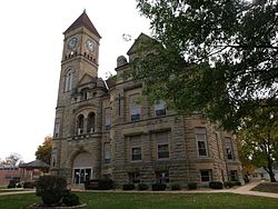
The first courthouse was built in 1861. The wooden, two-story building contained a courtroom, but was used for other purposes, including housing the office of the sheriff, county treasurer, the judge, as well as a chamber for the jury. The cornerstone for a second courthouse was laid on November 11, 1891. [5]

Geography

According to the U.S. Census Bureau, the county has a total area of 502 square miles (1,300 km2), of which 502 square miles (1,300 km2) is land and 0.04 square miles (0.10 km2) (0.01%) is water. [6]

Major highways

Adjacent counties

Demographics

Historical population
CensusPop.Note
1860 793
1870 6,399706.9%
1880 12,63997.5%
1890 13,2154.6%
1900 13,7574.1%
1910 13,574−1.3%
1920 14,4206.2%
1930 14,133−2.0%
1940 13,518−4.4%
1950 13,7221.5%
1960 14,1323.0%
1970 14,119−0.1%
1980 14,3661.7%
1990 12,029−16.3%
2000 12,3692.8%
2010 12,4530.7%
2020 12,329−1.0%
2023 (est.)12,384 [7] 0.4%
U.S. Decennial Census [8]
1790-1960 [9] 1900-1990 [10]
1990-2000 [11] 2010-2018 [12]
Population of Grundy County from US census data GrundyCountyIowaPop2020.png
Population of Grundy County from US census data

2020 census

2022 US Census population pyramid for Grundy County from ACS 5-year estimates GrundyCountyIA2022PopPyr.png
2022 US Census population pyramid for Grundy County from ACS 5-year estimates

The 2020 census recorded a population of 12,329 in the county, with a population density of

2010 census

The 2010 census recorded a population of 12,453 in the county, with a population density of

2000 census

At the 2000 census, [14] there were 12,369 people, 4,984 households and 3,583 families residing in the county. The population density was 25 inhabitants per square mile (9.7/km2). There were 5,304 housing units at an average density of 11 per square mile (4.2/km2). The racial makeup of the county was 98.97% White, 0.08% Black or African American, 0.02% Native American, 0.29% Asian, 0.15% from other races, and 0.48% from two or more races. 0.58% of the population were Hispanic or Latino of any race.

There were 4,984 households, of which 30.70% had children under the age of 18 living with them, 63.80% were married couples living together, 5.50% had a female householder with no husband present, and 28.10% were non-families. 25.50% of all households were made up of individuals, and 14.20% had someone living alone who was 65 years of age or older. The average household size was 2.45 and the average family size was 2.94.

25.20% of the population were under the age of 18, 6.30% from 18 to 24, 25.10% from 25 to 44, 24.10% from 45 to 64, and 19.30% who were 65 years of age or older. The median age was 41 years. For every 100 females, there were 95.70 males. For every 100 females age 18 and over, there were 92.10 males.

The median household income was $39,396,] and the median family income was $46,627. Males had a median income of $32,006 and females $22,003. The per capita income was $19,142. About 3.30% of families and 4.60% of the population were below the poverty line, including 4.60% of those under age 18 and 5.70% of those age 65 or over.

Communities

Townships

Population ranking

The population ranking of the following table is based on the 2020 census of Grundy County. [1]

county seat

RankCity/Town/etc.Municipal typePopulation (2020 Census)
1 Grundy Center City2,796
2 Reinbeck City1,662
3 Dike City1,304
4 Conrad City1,093
5 Wellsburg City720
6 Holland City269
7 Stout City191
8 Beaman City161
9 Morrison City98

Politics

Grundy County has long been one of the most consistently Republican counties in Iowa. The county has only voted for a candidate of a different party four times since the county was founded in 1851. The first occasion was in 1912, when former Republican Theodore Roosevelt won the county as the Progressive candidate. During his two landslide victories of 1932 and 1936, Franklin D. Roosevelt became the first Democrat to win Grundy County in its history. The final time a non-Republican candidate carried the county was in 1964, when Lyndon B. Johnson won in a nationwide landslide. No Democratic candidate has ever received more than 60% of the vote in the county, and in the last twenty elections (beginning in 1944), the Republican obtained at least 60% of the vote in fifteen of them, and the Republicans have hit at least 65% in nine of the twenty elections in that span.

United States presidential election results for Grundy County, Iowa [15]
Year Republican Democratic Third party
No.%No.%No.%
2020 4,92967.74%2,20630.32%1411.94%
2016 4,52765.88%1,85627.01%4897.12%
2012 4,21560.54%2,63537.85%1121.61%
2008 3,94557.77%2,79040.86%941.38%
2004 4,42964.67%2,38634.84%340.50%
2000 3,85163.02%2,13935.00%1211.98%
1996 2,92851.49%2,32240.83%4377.68%
1992 3,16051.33%1,89530.78%1,10117.88%
1988 3,43360.42%2,21138.91%380.67%
1984 4,52769.45%1,91529.38%761.17%
1980 4,64466.10%1,86926.60%5137.30%
1976 4,17362.66%2,41036.19%771.16%
1972 4,70671.03%1,84427.83%751.13%
1968 4,86671.14%1,67524.49%2994.37%
1964 3,21547.22%3,58252.61%110.16%
1960 4,98969.62%2,17430.34%30.04%
1956 4,91571.99%1,90827.95%40.06%
1952 5,65278.98%1,48320.72%210.29%
1948 3,15455.85%2,34441.51%1492.64%
1944 3,62562.14%2,19137.56%180.31%
1940 3,90858.56%2,74541.13%210.31%
1936 2,65639.62%3,91858.45%1291.92%
1932 2,41939.44%3,66159.68%540.88%
1928 3,67169.03%1,62030.46%270.51%
1924 3,32257.84%61510.71%1,80631.45%
1920 4,66285.82%71413.14%561.03%
1916 2,12767.23%1,01532.08%220.70%
1912 42113.60%1,14937.12%1,52549.27%
1908 1,86161.77%1,10536.67%471.56%
1904 2,02166.55%93830.89%782.57%
1900 2,02561.79%1,20336.71%491.50%
1896 1,89460.36%1,20638.43%381.21%

See also

Related Research Articles

<span class="mw-page-title-main">Clay County, Iowa</span> County in Iowa, United States

Clay County is a county located in the U.S. state of Iowa. As of the 2020 census, the population was 16,384. Its county seat is Spencer. Its name is in honor of Henry Clay Jr., a colonel who died in action in the Mexican–American War, and son of Henry Clay, famous American statesman from Kentucky.

<span class="mw-page-title-main">Buchanan County, Virginia</span> County in Virginia, United States

Buchanan County is a United States county in far western Virginia, the only county in the state to border both West Virginia and Kentucky. The county is part of the Southwest Virginia region and lies in the rugged Appalachian Plateau portion of the Appalachian Mountains. Its county seat is Grundy.

<span class="mw-page-title-main">Webster County, Iowa</span> County in Iowa, United States

Webster County is a county in the U.S. state of Iowa. As of the 2020 census, the population was 36,999. The county seat is Fort Dodge. The county was established in January 1851, one of 43 counties established by a legislative package. This county was named after Daniel Webster, an American statesman noted for his moving oratory.

<span class="mw-page-title-main">Tama County, Iowa</span> County in Iowa, United States

Tama County is a county located in the U.S. state of Iowa. As of the 2020 census, the population was 17,135. Its county seat is Toledo. The county was formed on February 17, 1843 and named for Taimah, a leader of the Meskwaki people.

<span class="mw-page-title-main">O'Brien County, Iowa</span> County in Iowa, United States

O'Brien County is a county in the U.S. state of Iowa. As of the 2020 United States Census, the population was 14,182. The county seat is Primghar.

<span class="mw-page-title-main">Marshall County, Iowa</span> County in Iowa, United States

Marshall County is a county located in the U.S. state of Iowa. As of the 2020 census, the population was 40,105. The county seat and largest city is Marshalltown. The county was formed on January 13, 1846, and named after John Marshall, Chief Justice of the United States Supreme Court.

<span class="mw-page-title-main">Hardin County, Iowa</span> County in Iowa, United States

Hardin County is a county located in the U.S. state of Iowa. As of the 2020 census, the population was 16,878. The county seat is Eldora. The county was named in honor of Col. John J. Hardin, of Illinois, who was killed in the Mexican–American War.

<span class="mw-page-title-main">Guthrie County, Iowa</span> County in Iowa, United States

Guthrie County is a county located in the U.S. state of Iowa. As of the 2020 census, the population was 10,623. The county seat is Guthrie Center. The county was formed on January 15, 1851, and named after Captain Edwin B. Guthrie, who died in the Mexican–American War.

<span class="mw-page-title-main">Floyd County, Iowa</span> County in Iowa, United States

Floyd County is a county located in the U.S. state of Iowa. As of the 2020 census, the population was 15,627. The county seat is Charles City.

<span class="mw-page-title-main">Cerro Gordo County, Iowa</span> County in Iowa, United States

Cerro Gordo County is a county located in the U.S. state of Iowa. As of the 2020 census, the population was 43,127. Its county seat is Mason City. The county is named for the Battle of Cerro Gordo, which took place during the Mexican–American War.

<span class="mw-page-title-main">Butler County, Iowa</span> County in Iowa, United States

Butler County is a county located in the U.S. state of Iowa. As of the 2020 census, the population was 14,334. Its county seat is Allison. The county was organized in 1854 and named for General William O. Butler.

<span class="mw-page-title-main">Buchanan County, Iowa</span> County in Iowa, United States

Buchanan County is a county located in the U.S. state of Iowa. As of the 2020 census, the population was 20,565. Its county seat is Independence. The county was created in 1837 and was named in honor of Senator James Buchanan, the 15th President of the United States.

<span class="mw-page-title-main">Harpers Ferry, Iowa</span> City in Iowa, United States

Harpers Ferry is a city in Taylor Township, Allamakee County, Iowa, United States. The population was 262 at the time of the 2020 census.

<span class="mw-page-title-main">Grundy Center, Iowa</span> City in Iowa, United States

Grundy Center is a city in Grundy County, Iowa. The population was 2,796 at the time of the 2020 census, a 7.7% increase from 2,596 at the 2000 census. Grundy Center is also the county seat of Grundy County. Grundy Center is part of the Waterloo–Cedar Falls Metropolitan Statistical Area.

<span class="mw-page-title-main">Holland, Iowa</span> City in Iowa, United States

Holland is a city in Grundy County, Iowa, United States. The population was 269 at the time of the 2020 census. It is part of the Waterloo–Cedar Falls Metropolitan Statistical Area.

<span class="mw-page-title-main">South Gull Lake, Michigan</span> Census-designated place & unincorporated community in Michigan, United States

South Gull Lake is a census-designated place (CDP) in Ross Township, Kalamazoo County, in the U.S. state of Michigan. It includes the unincorporated communities of Yorkville, Gull Lake, and Midland Park and does not have any legal status as an incorporated municipality. The population of the CDP was 1,182 at the 2010 census, down from 1,526 at the 2000 census.

Great Bend Township is a township in Cottonwood County, Minnesota, United States. The population was 287 at the 2010 census.

Midway Township is a township in Cottonwood County, Minnesota, United States. The population was 219 at the 2010 census. The city of Mountain Lake is located in the township.

<span class="mw-page-title-main">Marshallton, Pennsylvania</span> CDP in Pennsylvania, United States

Marshallton is a census-designated place (CDP), located in Coal Township, in Northumberland County, Pennsylvania, United States. The population was 1,441 at the 2010 census.

Morales-Sanchez is a census-designated place (CDP) in Zapata County, Texas, United States. The population was 84 at the 2010 census.

References

  1. 1 2 3 "2020 Census State Redistricting Data". census.gov. United states Census Bureau. Retrieved August 12, 2021.
  2. "Find a County". National Association of Counties. Archived from the original on May 31, 2011. Retrieved June 7, 2011.
  3. Gannett, Henry (1905). The Origin of Certain Place Names in the United States. Govt. Print. Off. pp.  145.
  4. United States Office of Management and Budget. "Update of Statistical Area Definitions and Guidance on Their Uses" (PDF). pp. 5, 36. Archived from the original (PDF) on May 14, 2006. Retrieved July 21, 2006.
  5. "Welcome to Grundy County". Archived from the original on February 17, 2008. Retrieved January 20, 2008.
  6. "US Gazetteer files: 2010, 2000, and 1990". United States Census Bureau. February 12, 2011. Retrieved April 23, 2011.
  7. "Annual Estimates of the Resident Population for Counties: April 1, 2020 to July 1, 2023". United States Census Bureau. Retrieved April 2, 2024.
  8. "U.S. Decennial Census". United States Census Bureau. Retrieved July 17, 2014.
  9. "Historical Census Browser". University of Virginia Library. Retrieved July 17, 2014.
  10. "Population of Counties by Decennial Census: 1900 to 1990". United States Census Bureau. Retrieved July 17, 2014.
  11. "Census 2000 PHC-T-4. Ranking Tables for Counties: 1990 and 2000" (PDF). United States Census Bureau. Archived (PDF) from the original on March 27, 2010. Retrieved July 17, 2014.
  12. "State & County QuickFacts". United States Census Bureau. Archived from the original on June 7, 2011. Retrieved July 17, 2014.
  13. "Population & Housing Occupancy Status 2010" (PDF). United States Census Bureau American FactFinder. Archived (PDF) from the original on October 16, 2020. Retrieved August 15, 2022.
  14. "U.S. Census website". United States Census Bureau . Retrieved January 31, 2008.
  15. Leip, David. "Dave Leip's Atlas of U.S. Presidential Elections". uselectionatlas.org. Retrieved April 26, 2018.

42°24′06″N92°47′15″W / 42.40167°N 92.78750°W / 42.40167; -92.78750