U.S. Route 30 or U.S. Highway 30 (US 30) is an east–west main route of the United States Numbered Highway System, with the highway traveling across the Northern U.S. With a length of 3,112 miles (5,008 km), it is the third-longest U.S. Highway, after US 20 and US 6. The western end of the highway is at US 101 in Astoria, Oregon; the eastern end is at Virginia Avenue, Absecon Boulevard, and Adriatic Avenue in Atlantic City, New Jersey. The "0" as the last digit in the number indicates that it is a coast-to-coast route and a major east–west route. Despite long stretches of parallel and concurrent Interstate Highways, it has not been decommissioned unlike other long-haul routes such as US 66. It is also the only U.S. Highway that has always been coast-to-coast since the beginning of U.S. Numbered Highway System.

U.S. Route 20 or U.S. Highway 20 (US 20) is an east–west United States Numbered Highway that stretches from the Pacific Northwest east to New England. The "0" in its route number indicates that US 20 is a major coast-to-coast route. Spanning 3,365 miles (5,415 km), it is the longest road in the United States, and, in the east, the route is roughly parallel to Interstate 90 (I-90), which is the longest Interstate Highway in the U.S. There is a discontinuity in the official designation of US 20 through Yellowstone National Park, with unnumbered roads used to traverse the park.

U.S. Route 52 (US 52) is a major United States highway in the central United States that extends from the northern to southeastern region of the United States. Contrary to most other even-numbered U.S. Highways, US 52 primarily follows a northwest–southeast route, and is signed north–south or east–west depending on the local orientation of the route. The highway's northwestern terminus is in Portal, North Dakota at the Canada–United States border, where it continues as Saskatchewan Highway 39. Its southeastern terminus is in Charleston, South Carolina, at Number 2 Meeting Street and White Point Garden along the Charleston Harbor.

U.S. Route 65 is a north–south United States highway in the southern and midwestern United States. The southern terminus of the route is at U.S. Route 425 in Clayton, Louisiana. The northern terminus is at Interstate 35 just south of Interstate 90 in Albert Lea, Minnesota. Parts of its modern route in Iowa and historic route in Minnesota follow the old Jefferson Highway.

U.S. Highway 151 (US 151) is a United States Numbered Highway that runs through the states of Iowa and Wisconsin. The southern terminus for US 151 is at a junction with Interstate 80 (I-80) in Iowa County, Iowa, and its northern terminus is at Manitowoc, Wisconsin. The route, from south to north follows a northeasterly path through the two states.
The Avenue of the Saints is a 563-mile-long (906 km) highway in the Midwestern United States that connects St. Louis, Missouri, and St. Paul, Minnesota.
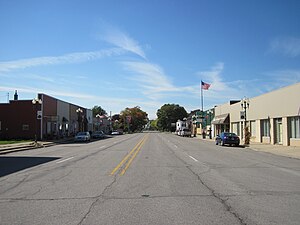
U.S. Highway 218 (US 218) is an original United States Highway that was created in 1926. Although technically a spur of US 18, US 218 neither begins nor ends at US 18, but overlaps US 18 for eight miles (13 km) near Charles City, Iowa. US 218 begins at U.S. 136 in downtown Keokuk and ends 319 miles (513 km) away at Interstate 35 (I-35) and US 14 at Owatonna, Minnesota. A large portion of US 218 in Iowa is part of the Avenue of the Saints, which connects St. Louis, Missouri, and Saint Paul, Minnesota.

Iowa Highway 9 is the most northern of Iowa's east–west highways, traversing the entire northern tier of counties. It runs from the eastern terminus of South Dakota Highway 42 at the South Dakota border east of Sioux Falls, South Dakota near Benclare, to the Wisconsin border at Lansing where it continues as Wisconsin Highway 82. It is largely rural in character, bypassing any large city. Making a few dips north and south, the highway largely follows a very straight east–west alignment.
State Trunk Highway 54 is a Wisconsin state highway running east–west across central Wisconsin. It is 243.12 miles (391.26 km) in length.
U.S. Route 78 (US 78) is an east–west United States Numbered Highway that runs for 843.3 miles (1,357.2 km) from Cash, Arkansas, to Charleston, South Carolina. From Byhalia, Mississippi to Birmingham, Alabama, US 78 runs concurrently with Interstate 22 (I-22). The highway’s western terminus is at I-57/US 67 near Cash, and its eastern terminus is on Line Street, in Charleston. Prior to November 2023, before the western extension, the highway's former western terminus was at US 64/US 70/US 79 in Memphis, Tennessee.

Iowa Highway 100 is a state highway located in Linn County, Iowa. The route is located primarily in Cedar Rapids and Marion and is known locally as Collins Road. It begins at US 30 / US 218 in western Cedar Rapids and ends at U.S. Highway 151 / Iowa Highway 13 in Marion.

Iowa Highway 2 is a 251-mile-long (404 km) state highway which runs across the southernmost tier of counties in the U.S. state of Iowa. At no point along its route is Iowa 2 more than 15 miles (24 km) from the Missouri state line, except for a small section near its eastern terminus. Iowa 2 stretches across the entire state; from the Missouri River near Nebraska City, Nebraska, to U.S. Highway 61 (US 61) at Fort Madison. Prior to becoming a primary highway, the route was known as the Waubonsie Trail.

Iowa Highway 14 (Iowa 14) is a state highway that runs from north to south across the state of Iowa for 188 miles (303 km). The begins in Corydon at an intersection with Iowa 2 and ends in Charles City at an intersection with U.S. Highway 18 (US 18) and US 218 Business.
U.S. Highway 20 (US 20) in Iowa is a major east–west artery which runs across the state, separating the northern third of Iowa from the southern two-thirds. It enters Iowa from Nebraska, concurrent with Interstate 129 (I-129) and US 75, crossing the Missouri River at Sioux City. US 20 runs in a more-or-less straight line across Iowa, paralleling 42° 27' N. It leaves Iowa in Dubuque by crossing the Mississippi River into Illinois. Since October 2018, US 20 is a four-lane divided highway for its entire length in Iowa.

Iowa Highway 175 (Iowa 175) is a main east–west route in the northern portion of the state. The highway has a length of 221 miles (356 km). Iowa Highway 175 enters the state by a Missouri River crossing between Decatur, Nebraska and Onawa. The highway continues westward as Nebraska Highway 51. Iowa 175's eastern terminus is at a T intersection with U.S. Highway 63 (US 63) in southwestern Black Hawk County.

Iowa Highway 16 is a state highway running from west to east in southeastern Iowa. The highway has a length of 65.18 miles (104.90 km). The western terminus of Iowa Highway 16 is at an intersection with U.S. Highway 34 (US 34) between Agency and Batavia. The eastern terminus is located at Wever at an intersection with US 61.

Iowa Highway 58 is a state highway that runs from north to south in northeast Iowa. A five-and-a-half-mile (8.9 km) portion of the highway is overlapped by the Avenue of the Saints. Iowa 58 begins at U.S. Highway 63 (US 63) in Hudson and ends at an interchange with US 218 and Iowa 57. Iowa 58's route has changed many times in its history, but has always served Black Hawk County.

Iowa Highway 330 is a 47-mile-long (76 km) state highway that travels northeasterly from Altoona past Albion, to just north of Marshalltown in Marshall County. Originally the two-lane, unpaved road was numbered Iowa 88. It became part of Iowa 64 in the 1903s and it received its current route number in 1969. Iowa 330 is mostly a four-lane, divided expressway along much of its length. In conjunction with U.S. Route 65 (US 65), Iowa 14 and US 20, Iowa 330 is commonly used as a connector between Des Moines and the Waterloo–Cedar Falls area.

U.S. Highway 26 (US-26) runs east–west across south central Idaho for 402.5 miles (647.8 km). US-26 enters the state from Oregon across the Snake River east of Nyssa, Oregon, concurrent with US-20 and exits into Wyoming northwest of Alpine. US-26 runs through the large population centers of Boise and Idaho Falls, as well as the smaller communities of Parma, Notus, Garden City, Shoshone, Richfield, Carey, Arco, Blackfoot, Swan Valley, and Irwin.

U.S. Highway 18 (US 18) is the northernmost east–west United States Numbered Highway in the state of Iowa. As with all state highways in Iowa, it is maintained by the Iowa Department of Transportation. It enters the state by crossing the Big Sioux River between Inwood and Canton, South Dakota. It travels about 312 miles (502 km) and connects Spencer, Mason City, and Charles City. The highway leaves the state via the Marquette–Joliet Bridge over the Mississippi River at Marquette. Prior to becoming a U.S. Highway, the route US 18 follows was known as Primary Road No. 19 and the National Parks Pike.