Warren County, Iowa

Last updated

Warren County
Warren County Iowa new courthouse.jpg
New courthouse under construction as of Dec 2021
Map of Iowa highlighting Warren County.svg
Location within the U.S. state of Iowa
Iowa in United States.svg
Iowa's location within the U.S.
Coordinates: 41°20′N93°34′W / 41.33°N 93.56°W / 41.33; -93.56
CountryFlag of the United States.svg United States
StateFlag of Iowa.svg  Iowa
Founded1846
Named for Joseph Warren
Seat Indianola
Largest cityIndianola
Area
  Total573 sq mi (1,480 km2)
  Land570 sq mi (1,500 km2)
  Water3.5 sq mi (9 km2)  0.6%
Population
 (2020)
  Total52,403
  Density91/sq mi (35/km2)
Time zone UTC−6 (Central)
  Summer (DST) UTC−5 (CDT)
Congressional district 1st
Website www.warrencountyia.org

Warren County is a county located in the U.S. state of Iowa. As of the 2020 census, the population was 52,403. [1] The county seat is Indianola. [2]

Contents

Warren County is included in the Des Moines West Des Moines, IA Metropolitan Statistical Area. [3]

History

Warren County was formed in 1846. It was named after General Joseph Warren, a hero in the American Revolutionary War. [4] The present Warren County Court House was opened in 1939. [5]

Geography

According to the U.S. Census Bureau, the county has a total area of 573 square miles (1,480 km2), of which 570 square miles (1,500 km2) is land and 3.5 square miles (9.1 km2) (0.6%) is water. [6]

Major highways

Adjacent counties

Demographics

Historical population
CensusPop.Note
1850 961
1860 10,281969.8%
1870 17,98074.9%
1880 19,5788.9%
1890 18,269−6.7%
1900 20,37611.5%
1910 18,194−10.7%
1920 18,047−0.8%
1930 17,700−1.9%
1940 17,6950.0%
1950 17,7580.4%
1960 20,82917.3%
1970 27,43231.7%
1980 34,87827.1%
1990 36,0333.3%
2000 40,67112.9%
2010 46,22513.7%
2020 52,40313.4%
2023 (est.)55,205 [7] 5.3%
U.S. Decennial Census [8]
1790-1960 [9] 1900-1990 [10]
1990-2000 [11] 2010-2018 [12]
Population of Warren County from US census data WarrenCountyIowaPop2020.png
Population of Warren County from US census data

2020 census

The 2020 census recorded a population of 52,403 in the county, with a population density of

Warren County Racial Composition [13]
RaceNum.Perc.
White (NH)47,89791.4%
Black or African American (NH)4520.9%
Native American (NH)800.2%
Asian (NH)3800.73%
Pacific Islander (NH)170.03%
Other/Mixed (NH)1,9193.7%
Hispanic or Latino 1,6583.2%

2010 census

The 2010 census recorded a population of 46,225 in the county, with a population density of

2000 census

2000 Census Age Pyramid for Warren County USA Warren County, Iowa age pyramid.svg
2000 Census Age Pyramid for Warren County

At the 2000 census there were 40,671 people, 14,708 households, and 11,207 families in the county. The population density was 71 inhabitants per square mile (27/km2). There were 15,289 housing units at an average density of 27 per square mile (10/km2). The racial makeup of the county was 98.08% White, 0.27% Black or African American, 0.17% Native American, 0.38% Asian, 0.04% Pacific Islander, 0.29% from other races, and 0.76% from two or more races. 1.08%. [15] were Hispanic or Latino of any race.

Of the 14,708 households 37.80% had children under the age of 18 living with them, 64.50% were married couples living together, 8.80% had a female householder with no husband present, and 23.80% were non-families. 19.90% of households were one person and 8.70% were one person aged 65 or older. The average household size was 2.65 and the average family size was 3.05.

The age distribution was 27.00% under the age of 18, 9.70% from 18 to 24, 28.20% from 25 to 44, 23.20% from 45 to 64, and 11.80% 65 or older. The median age was 36 years. For every 100 females, there were 94.60 males. For every 100 females age 18 and over, there were 91.80 males.

The median household income was $50,349 and the median family income was $56,344. Males had a median income of $36,983 versus $26,768 for females. The per capita income for the county was $20,558. About 3.70% of families and 5.10% of the population were below the poverty line, including 6.40% of those under age 18 and 5.20% of those age 65 or over.

Communities

Cities

Unincorporated communities

  1. Ourtown E&J.L.B.A's

Townships

Warren County has sixteen townships: [19]

Population ranking

The population ranking of the following table is based on the 2020 census of Warren County. [1]

county seat

RankCity/Town/etc.Municipal typePopulation (2020 Census)
1 Des Moines (mostly in Polk County )City214,133
2 West Des Moines (partially in Dallas and Polk Counties)City68,723
3 Indianola City15,833
4 Norwalk (partially in Polk County)City12,799
5 Carlisle (partially in Polk County)City4,160
6 Milo City778
7 Hartford City733
8 New Virginia City498
9 Cumming City436
10 Martensdale City421
11 Lacona City345
12 Ackworth City115
13 St. Marys City108
14 Spring Hill City68
15 Sandyville City58
16 Bevington (partially in Madison County )City57

Politics

United States presidential election results for Warren County, Iowa [20]
Year Republican Democratic Third party
No.%No.%No.%
2020 17,78257.29%12,57440.51%6832.20%
2016 14,81454.26%10,41138.14%2,0757.60%
2012 13,05250.06%12,55148.14%4691.80%
2008 12,14448.79%12,29949.42%4461.79%
2004 12,16052.75%10,73046.54%1630.71%
2000 9,62148.95%9,52148.45%5112.60%
1996 6,90539.52%9,12052.20%1,4478.28%
1992 7,24237.80%8,61244.95%3,30317.24%
1988 6,42439.82%9,62759.68%800.50%
1984 8,27749.95%8,17149.31%1220.74%
1980 7,36047.43%6,61042.59%1,5499.98%
1976 6,09943.23%7,65354.25%3562.52%
1972 7,33257.26%5,14340.17%3292.57%
1968 5,61950.30%4,61341.29%9398.41%
1964 3,67935.54%6,63964.14%330.32%
1960 6,01359.25%4,13640.75%00.00%
1956 5,43059.19%3,72940.65%150.16%
1952 5,91165.55%3,04233.74%640.71%
1948 3,87650.97%3,48145.77%2483.26%
1944 4,26655.83%3,31943.44%560.73%
1940 5,01656.21%3,85643.21%510.57%
1936 4,64252.72%4,01145.55%1521.73%
1932 3,72550.28%3,54247.81%1411.90%
1928 5,29469.74%2,23929.50%580.76%
1924 4,68362.08%1,27416.89%1,58621.03%
1920 5,32370.51%2,06627.37%1602.12%
1916 2,18252.21%1,91045.70%872.08%
1912 1,38634.21%1,39634.46%1,26931.33%
1908 2,58958.59%1,64537.23%1854.19%
1904 2,93866.20%1,19126.84%3096.96%
1900 2,96659.15%1,87637.42%1723.43%
1896 2,82655.27%2,21443.30%731.43%

See also

Related Research Articles

<span class="mw-page-title-main">Montgomery County, Iowa</span> County in Iowa, United States

Montgomery County is a county located in the southwestern area of the U.S. state of Iowa. As of the 2020 census, the population was 10,330. Its population has declined since a peak in 1900, since urbanization and decline of family farms. The county seat is Red Oak. The county was founded by European-American migrants from eastern areas in 1851. It was named in honor of Richard Montgomery, an American Revolutionary War general killed in 1775 while trying to capture Quebec City, Canada.

<span class="mw-page-title-main">Black Hawk County, Iowa</span> County in Iowa, United States

Black Hawk County is a county in the northeastern part of U.S. state of Iowa. As of the 2020 census, the population was 131,144, making it Iowa's fifth-most populous county. The county seat is Waterloo.

<span class="mw-page-title-main">Wapello County, Iowa</span> County in Iowa, United States

Wapello County is a county located in the U.S. state of Iowa. As of the 2020 census, the population was 35,437. The county seat is Ottumwa. The county was formed on February 17, 1843, and named for Wapello, a Meskwaki chief.

<span class="mw-page-title-main">Scott County, Iowa</span> County in Iowa, United States

Scott County is a county located in the U.S. state of Iowa. As of the 2020 census, the population was 174,669, making it the third-most populous county in Iowa. The county seat is Davenport.

<span class="mw-page-title-main">Polk County, Iowa</span> County in Iowa, United States

Polk County is located in the U.S. state of Iowa. As of the 2020 census, the population was 492,401. It is Iowa's most populous county, and home to over 15% of the state's residents. The county seat is Des Moines, which is also the capital city of Iowa. Polk County is included in the Des Moines–West Des Moines, IA Metropolitan Statistical Area.

<span class="mw-page-title-main">Pocahontas County, Iowa</span> County in Iowa, United States

Pocahontas County is a county located in Iowa, United States. As of the 2020 census the population was 7,078, making it the state's ninth-least populous county. The county seat is Pocahontas. The county was formed in 1851.

<span class="mw-page-title-main">Mahaska County, Iowa</span> County in Iowa, United States

Mahaska County is a county located in the U.S. state of Iowa. As of the 2020 census, the population was 22,190. The county seat is Oskaloosa.

<span class="mw-page-title-main">Madison County, Iowa</span> County in Iowa, United States

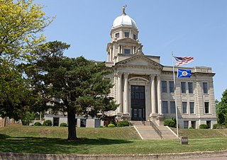
Madison County is a county located in the U.S. state of Iowa. As of the 2020 census, the population was 16,548. The county seat is Winterset.

<span class="mw-page-title-main">Jasper County, Iowa</span> County in Iowa, United States

Jasper County is a county in the U.S. state of Iowa. As of the 2020 census, the population was 37,813. The county seat is Newton. The county was organized in 1846 and is named after Sergeant William Jasper, a Revolutionary War hero.

<span class="mw-page-title-main">Henry County, Iowa</span> County in Iowa, United States

Henry County is a county located in the U.S. state of Iowa. As of the 2020 census, the population was 20,482. The county seat is Mount Pleasant. The county was named for General Henry Dodge, governor of Wisconsin Territory.

<span class="mw-page-title-main">Dallas County, Iowa</span> County in Iowa, United States

Dallas County is a county located in the U.S. state of Iowa. As of the 2020 Census, the population was 99,678, making it the seventh-most populous county in Iowa. Between 2010 and 2020, it was the fastest growing county in Iowa and one of the fastest growing in the country. Its county seat is Adel, and its largest city is Waukee. The county was named for George M. Dallas, Vice President of the United States under James K. Polk, the namesake of neighboring Polk County.

<span class="mw-page-title-main">Calhoun County, Iowa</span> County in Iowa, United States

Calhoun County is a county located in the U.S. state of Iowa. As of the 2020 census, the population was 9,927. Its county seat is Rockwell City.

<span class="mw-page-title-main">Elkhart, Iowa</span> City in Iowa, United States

Elkhart is a city in Polk County, Iowa, United States. The population was 882 at the time of the 2020 census. It is part of the Des Moines–West Des Moines Metropolitan Statistical Area.

<span class="mw-page-title-main">Johnston, Iowa</span> City in Iowa, United States

Johnston is a city in Polk County, Iowa, United States. The population was 24,064 in the 2020 census, a large increase from the 8,649 population in 2000. It is part of the Des Moines–West Des Moines Metropolitan Statistical Area.

<span class="mw-page-title-main">Hartford, Iowa</span> City in Iowa, United States

Hartford is a city in Warren County, Iowa, United States. The population was 733 at the time of the 2020 census. It is part of the Des Moines–West Des Moines Metropolitan Statistical Area.

<span class="mw-page-title-main">Indianola, Iowa</span> City in Iowa, United States

Indianola is a city in Warren County, Iowa, United States, located 14 miles (23 km) south of downtown Des Moines. The population was 15,833 at the time of the 2020 census. It is the county seat of Warren County. Indianola is home to the National Balloon Classic, a nine-day hot air balloon festival held annually in the summer, the Des Moines Metro Opera, a world renowned major American Summer Opera Festival, and Simpson College.

<span class="mw-page-title-main">Milo, Iowa</span> City in Iowa, United States

Milo is a city in Warren County, Iowa, United States. The population was 778 at the time of the 2020 census. It is part of the Des Moines–West Des Moines Metropolitan Statistical Area.

<span class="mw-page-title-main">St. Marys, Iowa</span> City in Iowa, United States

St. Marys or Saint Marys is a city in Warren County, Iowa, United States. The population was 108 at the time of the 2020 census.

<span class="mw-page-title-main">Mitchellville, Iowa</span> City in Iowa, United States

Mitchellville is a city located in Polk and Jasper counties in the U.S. state of Iowa. The population was 2,485 at the time of the 2020 census.

<span class="mw-page-title-main">Bevington, Iowa</span> City in Iowa, United States

Bevington is a city in Madison and Warren Counties in the U.S. state of Iowa. The population was 57 at the 2020 census. It is part of the Des Moines–West Des Moines Metropolitan Statistical Area.

References

  1. 1 2 3 "2020 Census State Redistricting Data". census.gov. United states Census Bureau. Retrieved August 12, 2021.
  2. "Find a County". National Association of Counties. Retrieved June 7, 2011.
  3. United States Office of Management and Budget. "Update of Statistical Area Definitions and Guidance on Their Uses" (PDF). pp. 5, 36. Archived from the original (PDF) on May 14, 2006. Retrieved July 21, 2006.
  4. Warren County Archived October 8, 2007, at the Wayback Machine
  5. "Warren County Courthouse". Iowa Judicial Branch. Archived from the original on July 26, 2011. Retrieved February 9, 2011.
  6. "US Gazetteer files: 2010, 2000, and 1990". United States Census Bureau. February 12, 2011. Retrieved April 23, 2011.
  7. "Annual Estimates of the Resident Population for Counties: April 1, 2020 to July 1, 2023". United States Census Bureau. Retrieved April 2, 2024.
  8. "U.S. Decennial Census". United States Census Bureau. Retrieved July 20, 2014.
  9. "Historical Census Browser". University of Virginia Library. Retrieved July 20, 2014.
  10. "Population of Counties by Decennial Census: 1900 to 1990". United States Census Bureau. Retrieved July 20, 2014.
  11. "Census 2000 PHC-T-4. Ranking Tables for Counties: 1990 and 2000" (PDF). United States Census Bureau. Archived (PDF) from the original on March 27, 2010. Retrieved July 20, 2014.
  12. "State & County QuickFacts". United States Census Bureau. Archived from the original on June 7, 2011. Retrieved July 20, 2014.
  13. "P2 HISPANIC OR LATINO, AND NOT HISPANIC OR LATINO BY RACE – 2020: DEC Redistricting Data (PL 94-171) – Warren County, Iowa".
  14. "Population & Housing Occupancy Status 2010" (PDF). United States Census Bureau American FactFinder. Archived (PDF) from the original on October 16, 2020. Retrieved August 15, 2022.
  15. "U.S. Census website". United States Census Bureau . Retrieved January 31, 2008.
  16. Medora, Iowa
  17. Medora Post Office at Medora, Iowa
  18. Medora, Iowa
  19. "Warren County, Iowa, United States - Overview - Histopolis". www.histopolis.com. Retrieved April 28, 2018.
  20. Leip, David. "Dave Leip's Atlas of U.S. Presidential Elections". uselectionatlas.org. Retrieved April 28, 2018.

Further reading


41°20′N93°34′W / 41.33°N 93.56°W / 41.33; -93.56