Nashua, Iowa

Last updated

Nashua, Iowa
City
Welcome Sign Nashua, Iowa.JPG
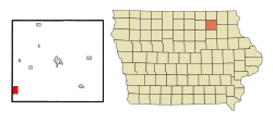
Chickasaw County Iowa Incorporated and Unincorporated areas Nashua Highlighted.svg
Location of Nashua, Iowa
Coordinates: 42°57′8″N92°32′17″W / 42.95222°N 92.53806°W / 42.95222; -92.53806
Country Flag of the United States (23px).png  United States
State Flag of Iowa.svg  Iowa
Counties Chickasaw, Floyd
Area
[1]
  Total3.18 sq mi (8.24 km2)
  Land2.92 sq mi (7.57 km2)
  Water0.26 sq mi (0.67 km2)
Elevation
974 ft (297 m)
Population
 (2020)
  Total1,551
  Density530.80/sq mi (204.98/km2)
Time zone UTC-6 (Central (CST))
  Summer (DST) UTC-5 (CDT)
ZIP code
50658
Area code 641
FIPS code 19-55335
GNIS feature ID0459437
Website www.nashua-iowa.com

Nashua is a city in Chickasaw County and Floyd County, Iowa. As of the 2020 census, the city's population was 1,551, a 6.7% decrease from 2010. [2] The famed Little Brown Church featured in the song "The Church in the Wildwood" is located in Nashua.

Contents

History

Little Brown Church Little Brown Church in Nashua, Iowa pic1.JPG
Little Brown Church

Nashua was incorporated as a city in 1869. It was held in 2020 that it is named after Nashua, New Hampshire, the native town of one of its founders. [3]

Geography

Nashua is located at 42°57′8″N92°32′17″W / 42.95222°N 92.53806°W / 42.95222; -92.53806 (42.952231, -92.537944). [4]

According to the United States Census Bureau, the city has a total area of 3.14 square miles (8.13 km2), of which 2.88 square miles (7.46 km2) is land and 0.26 square miles (0.67 km2) is water. [5]

Demographics

Historical populations
YearPop.±%
1870 817    
1880 1,116+36.6%
1890 1,240+11.1%
1900 1,268+2.3%
1910 1,102−13.1%
1920 1,317+19.5%
1930 1,363+3.5%
1940 1,439+5.6%
1950 1,609+11.8%
1960 1,737+8.0%
1970 1,712−1.4%
1980 1,846+7.8%
1990 1,476−20.0%
2000 1,618+9.6%
2010 1,663+2.8%
2020 1,551−6.7%
Source: "U.S. Census website". United States Census Bureau . Retrieved March 29, 2020. and Iowa Data Center
Source:
U.S. Decennial Census [6] [2]

2010 census

As of the census [7] of 2010, there were 1,663 people, 712 households, and 456 families living in the city. The population density was 577.4 inhabitants per square mile (222.9/km2). There were 787 housing units at an average density of 273.3 per square mile (105.5/km2). The racial makeup of the city was 98.6% White, 0.4% African American, 0.5% Asian, and 0.5% from two or more races. Hispanic or Latino of any race were 0.1% of the population.

There were 712 households, of which 29.6% had children under the age of 18 living with them, 51.5% were married couples living together, 9.0% had a female householder with no husband present, 3.5% had a male householder with no wife present, and 36.0% were non-families. 31.5% of all households were made up of individuals, and 17.7% had someone living alone who was 65 years of age or older. The average household size was 2.34 and the average family size was 2.95.

The median age in the city was 38.4 years. 26% of residents were under the age of 18; 8% were between the ages of 18 and 24; 22.6% were from 25 to 44; 23.5% were from 45 to 64; and 20% were 65 years of age or older. The gender makeup of the city was 49.1% male and 50.9% female.

2000 census

As of the census [8] of 2000, there were 1,618 people, 691 households, and 469 families living in the city. The population density was 658.2 inhabitants per square mile (254.1/km2). There were 739 housing units at an average density of 300.6 per square mile (116.1/km2). The racial makeup of the city was 99.26% White, 0.06% African American, 0.06% Native American, 0.19% Asian, 0.06% from other races, and 0.37% from two or more races. Hispanic or Latino of any race were 0.31% of the population.

There were 691 households, out of which 28.2% had children under the age of 18 living with them, 56.0% were married couples living together, 8.4% had a female householder with no husband present, and 32.1% were non-families. 27.1% of all households were made up of individuals, and 16.8% had someone living alone who was 65 years of age or older. The average household size was 2.34 and the average family size was 2.83.

25.2% are under the age of 18, 7.8% from 18 to 24, 23.5% from 25 to 44, 22.6% from 45 to 64, and 20.9% who were 65 years of age or older. The median age was 40 years. For every 100 females, there were 97.8 males. For every 100 females age 18 and over, there were 92.4 males.

The median income for a household in the city was $31,713, and the median income for a family was $37,284. Males had a median income of $27,969 versus $20,547 for females. The per capita income for the city was $16,031. About 5.7% of families and 9.0% of the population were below the poverty line, including 9.3% of those under age 18 and 8.7% of those age 65 or over.

Education

Nashua-Plainfield Community School District operates area public schools. [9] It was established on July 1, 1997, by the merger of the Nashua and Plainfield school districts. [10] It operates the following schools: [11]

Notable people


Related Research Articles

<span class="mw-page-title-main">Elk Run Heights, Iowa</span> City in Iowa, United States

Elk Run Heights is a city in Black Hawk County, Iowa, United States. The population was 1,069 at the 2020 census. It is part of the Waterloo–Cedar Falls Metropolitan Statistical Area.

<span class="mw-page-title-main">Hudson, Iowa</span> City in Iowa, United States

Hudson is a city in Black Hawk County, Iowa, United States. The population was 2,546 at the time of the 2020 census. The rural community of Hudson has grown in recent years and is included as a part of the Waterloo-Cedar Falls Metropolitan Statistical Area.

<span class="mw-page-title-main">Raymond, Iowa</span> City in Iowa, United States

Raymond is a city in Black Hawk County, Iowa, United States. The population was 759 at the time of the 2020 census. It is part of the Waterloo–Cedar Falls Metropolitan Statistical Area.

<span class="mw-page-title-main">Plainfield, Iowa</span> City in Iowa, United States

Plainfield is a city in Bremer County, Iowa, United States. The population was 393 at the 2020 census, a decrease of 45, or 10.3%, from 438 in 2000. It is part of the Waterloo–Cedar Falls Metropolitan Statistical Area.

<span class="mw-page-title-main">Fostoria, Iowa</span> City in Iowa, United States

Fostoria is a city in Clay County, Iowa, United States. The population was 230 in the 2020 census, unchanged from the 2000.

<span class="mw-page-title-main">Schleswig, Iowa</span> City in Iowa, United States

Schleswig is a city in Crawford County, Iowa, United States. The population was 830 at the time of the 2020 census.

<span class="mw-page-title-main">Wellsburg, Iowa</span> City in Iowa, United States

Wellsburg is a city in Grundy County, Iowa, United States. The population was 720 at the 2020 census, a slight increase from 716 in 2000. It is part of the Waterloo–Cedar Falls Metropolitan Statistical Area. The city is named for George Wells, an early settler in the region.

<span class="mw-page-title-main">Blairsburg, Iowa</span> City in Iowa, United States

Blairsburg is a city in Hamilton County, Iowa, United States. The population was 176 at the 2020 census.

<span class="mw-page-title-main">Lockridge, Iowa</span> City in Iowa, United States

Lockridge is a city in Jefferson County, Iowa, United States. The population was 244 at the time of the 2020 census. Lockridge was one of the communities considered for the county seat in 1839, but lost out to Fairfield.

<span class="mw-page-title-main">Kinross, Iowa</span> City in Iowa, United States

Kinross is a city in Keokuk County, Iowa, United States. The population was 80 at the time of the 2020 census. The community is named after Kinross in Scotland.

<span class="mw-page-title-main">Grandview, Iowa</span> City in Iowa, United States

Grandview is a city in Louisa County, Iowa, United States. The population was 437 at the time of the 2020 census. It is part of the Muscatine Micropolitan Statistical Area.

<span class="mw-page-title-main">Derby, Iowa</span> City in Iowa, United States

Derby is a city in Lucas County, Iowa, United States. The population was 90 at the time of the 2020 census.

<span class="mw-page-title-main">St. Anthony, Iowa</span> City in Iowa, United States

St. Anthony is a city in Marshall County, Iowa, United States. The population was 76 at the time of the 2020 census.

<span class="mw-page-title-main">Runnells, Iowa</span> City in Iowa, United States

Runnells is a city in the southeastern corner of Polk County, Iowa, United States. The population was 457 at the time of the 2020 census. It is part of the Des Moines–West Des Moines Metropolitan Statistical Area. Runnells has its own Post Office, located at 112 Brown Street.

<span class="mw-page-title-main">Hancock, Iowa</span> City in Iowa, United States

Hancock is a city in Pottawattamie County, Iowa, United States, along the West Nishnabotna River. The population was 200 at the time of the 2020 census.

<span class="mw-page-title-main">Macedonia, Iowa</span> City in Iowa, United States

Macedonia is a city in Pottawattamie County, Iowa, United States. The population was 267 at the time of the 2020 census.

<span class="mw-page-title-main">Treynor, Iowa</span> City in Iowa, United States

Treynor is a city in Pottawattamie County, Iowa, United States. The population was 1,032 as of the 2020 census.

<span class="mw-page-title-main">Adams, Minnesota</span> City in Minnesota, United States

Adams is a city in Adams Township, Mower County, Minnesota, United States. The population was 683 at the 2020 census, down from 787 in 2010.

<span class="mw-page-title-main">Valley View, Schuylkill County, Pennsylvania</span> CDP in Pennsylvania, United States

Valley View is a census-designated place (CDP) in Schuylkill County, Pennsylvania, United States. The population was 1,677 at the 2000 census.

<span class="mw-page-title-main">Barnes City, Iowa</span> City in Iowa, United States

Barnes City is a city in Mahaska and Poweshiek counties in the U.S. state of Iowa. The population was 156 at the 2020 census.

References

  1. "2020 U.S. Gazetteer Files". United States Census Bureau. Retrieved March 16, 2022.
  2. 1 2 "2020 Census State Redistricting Data". census.gov. United States Census Bureau. Retrieved August 12, 2021.
  3. Fairbairn, Robert Herd (1638). History of Chickasaw and Howard Counties, Iowa, Volume 1. S. J. Clarke Publishing Company. p. 291.
  4. "US Gazetteer files: 2010, 2000, and 1990". United States Census Bureau. February 12, 2011. Retrieved April 23, 2011.
  5. "US Gazetteer files 2010". United States Census Bureau. Archived from the original on July 2, 2012. Retrieved May 11, 2012.
  6. "Census of Population and Housing". Census.gov. Retrieved June 4, 2015.
  7. "U.S. Census website". United States Census Bureau . Retrieved May 11, 2012.
  8. "U.S. Census website". United States Census Bureau . Retrieved January 31, 2008.
  9. "Nashua-Plainfield" (PDF). Iowa Department of Education . Retrieved March 27, 2020.
  10. "REORGANIZATION & DISSOLUTION ACTIONS SINCE 1965-66" (PDF). Iowa Department of Education. Archived from the original (PDF) on February 9, 2019. Retrieved August 1, 2019.
  11. "Nashua-Plainfield School District".
  12. "PAPERS OF CHARLTON LAIRD". University of Iowa Libraries. Retrieved January 9, 2011.
  13. "Kent Taylor". Internet Movie Database . Retrieved March 5, 2013.