Niles Township | |
|---|---|
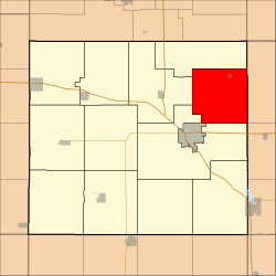 Location in Floyd County | |
| Coordinates: 43°07′25″N92°36′47″W / 43.12361°N 92.61306°W | |
| Country | |
| State | |
| County | Floyd |
| Area | |
• Total | 34.60 sq mi (89.62 km2) |
| • Land | 34.60 sq mi (89.62 km2) |
| • Water | 0 sq mi (0 km2) 0% |
| Elevation | 1,033 ft (315 m) |
| Population (2000) | |
• Total | 533 |
| • Density | 15/sq mi (5.9/km2) |
| Time zone | UTC-6 (CST) |
| • Summer (DST) | UTC-5 (CDT) |
| ZIP codes | 50616, 50645 |
| GNIS feature ID | 0468442 |
Niles Township is one of twelve townships in Floyd County, Iowa, United States. As of the 2000 census, its population was 533. [1]
