Park River, North Dakota

Last updated

Park River, North Dakota
Park River, North Dakota.jpg
Downtown Park River with grain elevators in the background
Motto: 
"The Town With a Heart"
ND Walsh County Park River.svg
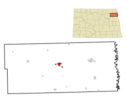
Location of Park River, North Dakota
Coordinates: 48°23′28″N97°44′34″W / 48.39111°N 97.74278°W / 48.39111; -97.74278
CountryUnited States
State North Dakota
County Walsh
Founded1884
Government
  MayorDan Stenvold
Area
[1]
  Total2.59 sq mi (6.71 km2)
  Land2.59 sq mi (6.71 km2)
  Water0.00 sq mi (0.00 km2)
Elevation
[2]
997 ft (304 m)
Population
 (2020)
  Total1,424
  Density549.81/sq mi (212.28/km2)
Time zone UTC-6 (CST)
  Summer (DST) UTC-5 (CDT)
ZIP code
58270
Area code 701
FIPS code 38-60900
GNIS feature ID1036213 [2]
Highways ND 17
Website cityofparkriver.com

Park River is a city in Walsh County, North Dakota, United States. The population was 1,424 at the 2020 census. [3] Park River was founded in 1884.

Contents

In 1903, a Park River blacksmith named Samuel Holland built a motor car called the Holland Special. He built at least five more cars between 1903 and 1908. [4]

Geography

According to the United States Census Bureau, the city has a total area of 2.17 square miles (5.62 km2), all land. [5]

Demographics

Historical population
CensusPop.Note
1890 534
1900 1,088103.7%
1910 1,008−7.4%
1920 1,11410.5%
1930 1,1311.5%
1940 1,40824.5%
1950 1,69220.2%
1960 1,8137.2%
1970 1,680−7.3%
1980 1,8449.8%
1990 1,725−6.5%
2000 1,535−11.0%
2010 1,403−8.6%
2020 1,4241.5%
2021 (est.)1,412 [6] −0.8%
U.S. Decennial Census [7]
2020 Census [3]

2010 census

At the 2010 census, there were 1,403 people, 643 households and 360 families living in the city. The population density was 646.5 per square mile (249.6/km2). There were 734 housing units at an average density of 338.2 per square mile (130.6/km2). The racial make-up of the population was 97.0% White, 1.3% Native American, 0.2% Asian, 0.4% from other races and 1.1% from two or more races. Hispanic or Latino people of any race were 2.4%. [8]

Of the 643 households, 23.5% had children under the age of 18 living with them, 44.6% were married couples living together, 8.6% had a female householder with no husband present, 2.8% had a male householder with no wife present and 44.0% were non-families. 39.7% of households were one person and 20.6% were one person aged 65 or older. The average household size was 2.07 and the average family size was 2.80.

The median age was 49.4 years. 21.2% of residents were under the age of 18; 4.3% were between the ages of 18 and 24; 19.1% were from 25 to 44; 28.1% were from 45 to 64; and 27.5% were 65 or older. The sex make-up of the city was 49.0% male and 51.0% female.

2000 census

At the 2000 census,, there were 1,535 people, 660 households and 390 families living in the city. The population density was 772.6 per square mile (298.3/km2). There were 760 housing units at an average density of 382.5 per square mile (147.7/km2). The racial make-up of the population was 95.57% White, 0.07% African American, 1.63% Native American, 0.07% Asian, 1.56% from other races and 1.11% from two or more races. Hispanic or Latino people of any race were 2.61% of the population.

Of the 660 households, 27.0% had children under the age of 18 living with them, 47.9% were married couples living together, 8.8% had a female householder with no husband present and 40.8% were non-families. 38.0% of households were one person and 20.8% were one person aged 65 or older. The average household size was 2.18 and the average family size was 2.88.

22.1% of the population was under the age of 18, 6.3% from 18 to 24, 20.9% from 25 to 44, 22.1% from 45 to 64 and 28.5% were 65 or older. The median age was 45 years. For every 100 females, there were 87.4 males. For every 100 females age 18 and over, there were 78.9 males.

The median household income was $30,347 and the median family income was $40,000. Males had a median income of $26,154 and females $20,769. The per capita income was $15,990. About 6.8% of families and 7.8% of the population were below the poverty line, including 9.1% of those under age 18 and 7.2% of those age 65 or over.

Climate

This climatic region is typified by large seasonal temperature differences, with warm to hot (and often humid) summers and cold (sometimes severely cold) winters. According to the Köppen Climate Classification system, Park River has a humid continental climate, abbreviated "Dfb" on climate maps. [9]

Notable people

See also

Related Research Articles

<span class="mw-page-title-main">Dakota City, Iowa</span> City in Iowa, United States

Dakota City is a city in and the county seat of Humboldt County, Iowa, United States. The population was 759 at the time of the 2020 census. Dakota City shares its western border with the much larger city of Humboldt. It is the least populous county seat in Iowa.

<span class="mw-page-title-main">Dakota, Minnesota</span> City in Minnesota, United States

Dakota is a city in Winona County, Minnesota, United States. The population was 295 at the 2020 census.

<span class="mw-page-title-main">Forest River, North Dakota</span> City in North Dakota, United States

Forest River is a city in Walsh County, North Dakota, United States. The population was 109 at the 2020 census. Forest River was founded on July 13, 1887.

<span class="mw-page-title-main">Springfield, South Dakota</span> City in South Dakota, United States

Springfield is a city in Bon Homme County, South Dakota, United States. The population was 1,914 at the 2020 census. As of 2012, about 1,200 of the residents were inmates at Mike Durfee State Prison.

<span class="mw-page-title-main">Columbia, South Dakota</span> City in South Dakota, United States

Columbia is an incorporated small town on the James River in Brown County, South Dakota, United States. The population was 160 at the 2020 census. There is a large granary co-op at Columbia, also a post office, a bank, a bar, a church, a town park, and a community center, in addition to the city hall; and many homes.

<span class="mw-page-title-main">Hecla, South Dakota</span> City in South Dakota, United States

Hecla is a city in Brown County, South Dakota, United States, located only a few miles south of the North Dakota border. The population was 193 at the 2020 census. State Highway 37 runs along the east side of town.

<span class="mw-page-title-main">Clear Lake, South Dakota</span> City in South Dakota, United States

Clear Lake is a city in and the county seat of Deuel County, South Dakota, United States. The population was 1,218 at the 2020 census.

<span class="mw-page-title-main">Milbank, South Dakota</span> City in South Dakota, United States

Milbank is a city in Grant County, South Dakota, United States, located along the South Fork of the Whetstone River. The population was 3,544 at the 2020 census. It is the county seat of Grant County. Milbank is the birthplace of American Legion Baseball. The program was created in Milbank in 1925 and is now enjoyed by high school aged youth on more than five thousand teams in all fifty states.

<span class="mw-page-title-main">Olivet, South Dakota</span> Town in South Dakota, United States

Olivet is a town in and the county seat of Hutchinson County, South Dakota. The population was 64 at the time of the 2020 census.

<span class="mw-page-title-main">Tea, South Dakota</span> City in South Dakota, United States

Tea is a city in Lincoln County, South Dakota, United States and is a suburb of Sioux Falls. The population was 5,598 at the 2020 census.

<span class="mw-page-title-main">Lake City, South Dakota</span> Town in South Dakota, United States

Lake City is a town in Marshall County, South Dakota, United States. The population was 45 at the 2020 census. Fort Sisseton Historic State Park, whose fort is listed on the National Register of Historic Places, is located nearby.

<span class="mw-page-title-main">Leola, South Dakota</span> City in South Dakota, United States

Leola is a small city in, and the county seat of, McPherson County, South Dakota, United States. It was founded on May 1, 1884, and named for Leola Haynes, daughter of one of the town's founders. The population was 434 as of the 2020 census.

<span class="mw-page-title-main">White River, South Dakota</span> City in South Dakota, United States

White River is a city in and the county seat of Mellette County. South Dakota, United States. The population was 533 at the 2020 census.

<span class="mw-page-title-main">Baltic, South Dakota</span> City in South Dakota, United States

Baltic is a city on the Big Sioux River in northern Minnehaha County, South Dakota, United States. The population was 1,246 at the 2020 census.

<span class="mw-page-title-main">Crooks, South Dakota</span> City in South Dakota, United States

Crooks is a city in Minnehaha County, South Dakota, United States and is a suburb of Sioux Falls. The population was 1,362 at the 2020 census. Crooks was named New Hope until 1904. The town's present name honors W. A. Crooks, a local politician.

<span class="mw-page-title-main">Dell Rapids, South Dakota</span> City in South Dakota, United States

Dell Rapids is a city in Minnehaha County, South Dakota, United States. The population was 3,996 at the 2020 census. It is known as "The Little City with the Big Attractions."

<span class="mw-page-title-main">Garretson, South Dakota</span> City in South Dakota, United States

Garretson is a city in Minnehaha County, South Dakota, United States. The city had a population of 1,228 at the 2020 census.

<span class="mw-page-title-main">Bison, South Dakota</span> Town in South Dakota, United States

Bison is a town in and the county seat of Perkins County, South Dakota, United States. The population was 302 at the 2020 census.

<span class="mw-page-title-main">Fort Pierre, South Dakota</span> City in South Dakota, United States

Fort Pierre is a city in Stanley County, South Dakota, United States. It is part of the Pierre, South Dakota micropolitan area and the county seat of Stanley County. The population was 2,115 at the 2020 census.

<span class="mw-page-title-main">Eagle Butte, South Dakota</span> City in South Dakota, United States

Eagle Butte is a city in Dewey and Ziebach counties in South Dakota, United States. The population was 1,258 at the 2020 census.

References

  1. "ArcGIS REST Services Directory". United States Census Bureau. Retrieved September 20, 2022.
  2. 1 2 U.S. Geological Survey Geographic Names Information System: Park River, North Dakota
  3. 1 2 "Explore Census Data". United States Census Bureau . Retrieved July 10, 2022.
  4. Jackson, William (2021). Dakota Mysteries & Oddities, 2022 Edition. Dickinson, ND: Valley Star Publishing. pp. 85–86. ISBN   978-0-9677349-9-6.
  5. "US Gazetteer files 2010". United States Census Bureau. Archived from the original on July 2, 2012. Retrieved June 14, 2012.
  6. "City and Town Population Totals: 2020-2021". United States Census Bureau. July 10, 2022. Retrieved July 10, 2022.
  7. United States Census Bureau. "Census of Population and Housing" . Retrieved August 7, 2013.
  8. "U.S. Census website". United States Census Bureau . Retrieved June 14, 2012.
  9. Climate Summary for Park River, North Dakota

Commons-logo.svg Media related to Park River, North Dakota at Wikimedia Commons