Fairdale, North Dakota

Last updated

Fairdale, North Dakota
Post office in Fairdale, North Dakota 7-19-2009.jpg
Post office in Fairdale
ND Walsh County Fairdale.svg
Location of Fairdale, North Dakota
Coordinates: 48°29′24″N98°13′52″W / 48.49000°N 98.23111°W / 48.49000; -98.23111
CountryUnited States
State North Dakota
County Walsh
Founded1905
Area
[1]
  Total0.32 sq mi (0.82 km2)
  Land0.32 sq mi (0.82 km2)
  Water0.00 sq mi (0.00 km2)
Elevation
[2]
1,618 ft (493 m)
Population
 (2020)
  Total30
  Density94.94/sq mi (36.60/km2)
Time zone UTC-6 (CST)
  Summer (DST) UTC-5 (CDT)
ZIP code
58229
Area code 701
FIPS code 38-25180
GNIS feature ID1036028 [2]

Fairdale is a city in Walsh County, North Dakota, United States. The population was 30 at the 2020 census. [3] Fairdale was founded in 1905.

Contents

Geography

According to the United States Census Bureau, the city has a total area of 0.31 square miles (0.80 km2), all land. [4]

Demographics

Historical population
CensusPop.Note
1910 140
1920 19237.1%
1930 171−10.9%
1940 1879.4%
1950 131−29.9%
1960 126−3.8%
1970 102−19.0%
1980 97−4.9%
1990 76−21.6%
2000 51−32.9%
2010 38−25.5%
2020 30−21.1%
2021 (est.)29 [5] −3.3%
U.S. Decennial Census [6]
2020 Census [3]

2010 census

As of the census of 2010, there were 38 people, 19 households, and 11 families living in the city. The population density was 122.6 inhabitants per square mile (47.3/km2). There were 33 housing units at an average density of 106.5 per square mile (41.1/km2). The racial makeup of the city was 92.1% White, 2.6% Asian, and 5.3% from other races. Hispanic or Latino of any race were 5.3% of the population.

There were 19 households, of which 5.3% had children under the age of 18 living with them, 52.6% were married couples living together, 5.3% had a female householder with no husband present, and 42.1% were non-families. 36.8% of all households were made up of individuals, and 10.5% had someone living alone who was 65 years of age or older. The average household size was 2.00 and the average family size was 2.55.

The median age in the city was 56.5 years. 10.5% of residents were under the age of 18; 10.5% were between the ages of 18 and 24; 5.2% were from 25 to 44; 36.9% were from 45 to 64; and 36.8% were 65 years of age or older. The gender makeup of the city was 63.2% male and 36.8% female.

2000 census

As of the census of 2000, there were 51 people, 26 households, and 15 families living in the city. The population density was 164.0 inhabitants per square mile (63.3/km2). There were 38 housing units at an average density of 122.2 per square mile (47.2/km2). The racial makeup of the city was 98.04% White and 1.96% Native American.

There were 26 households, out of which 19.2% had children under the age of 18 living with them, 50.0% were married couples living together, and 42.3% were non-families. 42.3% of all households were made up of individuals, and 23.1% had someone living alone who was 65 years of age or older. The average household size was 1.96 and the average family size was 2.67.

In the city, the population was spread out, with 17.6% under the age of 18, 2.0% from 18 to 24, 25.5% from 25 to 44, 15.7% from 45 to 64, and 39.2% who were 65 years of age or older. The median age was 58 years. For every 100 females, there were 131.8 males. For every 100 females age 18 and over, there were 110.0 males.

The median income for a household in the city was $11,250, and the median income for a family was $29,583. Males had a median income of $26,250 versus $10,833 for females. The per capita income for the city was $9,822. There were no families and 24.1% of the population living below the poverty line, including no under eighteens and 31.8% of those over 64.

Notable people

Related Research Articles

<span class="mw-page-title-main">Rembrandt, Iowa</span> City in Iowa, United States

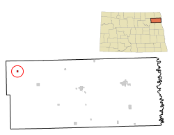
Rembrandt is a city in Buena Vista County, Iowa, United States. The population was 209 at the time of the 2020 census.

<span class="mw-page-title-main">Willey, Iowa</span> City in Iowa, United States

Willey is a city in Carroll County, Iowa, United States. The population was 73 at the time of the 2020 census.

<span class="mw-page-title-main">Delaware, Iowa</span> City in Iowa, United States

Delaware is a city in Delaware County, Iowa, United States. The population was 142 at the time of the 2020 census.

<span class="mw-page-title-main">Hayesville, Iowa</span> City in Iowa, United States

Hayesville is a city in Keokuk County, Iowa, United States. The population was 41 at the time of the 2020 census.

<span class="mw-page-title-main">Maysville, Iowa</span> City in Iowa, United States

Maysville is a city in Scott County, Iowa, United States. The population was 156 at the time of the 2020 census.

Fairdale is a former census-designated place in southern Jefferson County, Kentucky, United States. The population was 7,658 at the 2000 census. In 2003, the area was annexed to the city of Louisville due to a merger between the city and Jefferson County's unincorporated community. Fairdale is now a neighborhood within the city limits of Louisville. The ZIP Code for Fairdale is 40118.

It is within the boundaries of the Fairdale Fire Protection District which serves Fairdale and surrounding areas including the large Jefferson Memorial Forest and historic South Park Country Club, the oldest country club in the state of Kentucky.
<span class="mw-page-title-main">Wilton, Minnesota</span> City in Minnesota, United States

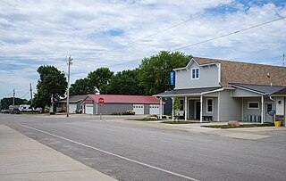
Wilton is a city in Beltrami County, Minnesota, United States. The population was 204 at the 2010 census. Wilton is considered a bedroom community of Bemidji.

<span class="mw-page-title-main">Felton, Minnesota</span> City in Minnesota, United States

Felton is a city in Clay County, Minnesota, United States. The population was 177 at the 2020 census.

<span class="mw-page-title-main">Lastrup, Minnesota</span> City in Minnesota, United States

Lastrup is a city in Morrison County, Minnesota, United States. The population was 120 at the 2020 census.

<span class="mw-page-title-main">Henning, Minnesota</span> City in Minnesota, United States

Henning is a city in Otter Tail County, Minnesota, United States. The population was 854 at the 2020 census.

<span class="mw-page-title-main">Richville, Minnesota</span> City in Minnesota, United States

Richville is a city in Otter Tail County, Minnesota, United States. The population was 77 as of the 2020 census.

<span class="mw-page-title-main">Leonidas, Minnesota</span> City in Minnesota, United States

Leonidas is a city in Saint Louis County, Minnesota, United States. The population was 52 at the 2010 census.

<span class="mw-page-title-main">Lake Henry, Minnesota</span> City in Minnesota, United States

Lake Henry is a city in Stearns County, Minnesota, United States. The population was 103 at the 2010 census. It is part of the St. Cloud Metropolitan Statistical Area.

<span class="mw-page-title-main">Country Club Hills, Missouri</span> City in Missouri, United States

Country Club Hills is a city in St. Louis County, Missouri, United States. The population was 1,274 at the 2010 census.

<span class="mw-page-title-main">Crystal Lake Park, Missouri</span> City in Missouri, United States

Crystal Lake Park is a Missouri Class 4 city in St. Louis County, Missouri, United States. The population was 508 at the 2020 census.

<span class="mw-page-title-main">Moline Acres, Missouri</span> City in Missouri, United States

Moline Acres is a city in St. Louis County, Missouri, United States. The population was 2,442 at the 2010 census.

<span class="mw-page-title-main">Harrisburg, Oregon</span> City in Oregon, United States

Harrisburg is a city in Linn County, Oregon, United States. The population was 3,567 at the 2010 census.

<span class="mw-page-title-main">Cumberland Township, Greene County, Pennsylvania</span> Township in Pennsylvania, United States

Cumberland Township is a township in Greene County, Pennsylvania, United States. The population was 6,399 at the 2020 census.

<span class="mw-page-title-main">Fairdale, Pennsylvania</span> Census-designated place in Pennsylvania, United States

Fairdale is a community and census-designated place (CDP) in Greene County, Pennsylvania, United States. The population was 2,059 at the 2010 census.

<span class="mw-page-title-main">Pennsboro, West Virginia</span> City in West Virginia, United States

Pennsboro is a city in Ritchie County, West Virginia, United States. The population was 1,050 at the 2020 census. The city is located at the junction of U.S. Route 50 and West Virginia Route 74; the North Bend Rail Trail also passes through the city.

References

  1. "ArcGIS REST Services Directory". United States Census Bureau. Retrieved September 20, 2022.
  2. 1 2 U.S. Geological Survey Geographic Names Information System: Fairdale, North Dakota
  3. 1 2 "Explore Census Data". United States Census Bureau . Retrieved July 23, 2022.
  4. "US Gazetteer files 2010". United States Census Bureau. Archived from the original on January 25, 2012. Retrieved June 14, 2012.
  5. "City and Town Population Totals: 2020-2021". United States Census Bureau. July 23, 2022. Retrieved July 23, 2022.
  6. United States Census Bureau. "Census of Population and Housing" . Retrieved January 19, 2014.
  7. 'Ed Kringstad-Obituary', The Bismarck Tribune.com, May 7, 2013