Climbing Hill, Iowa

Last updated • 2 min readFrom Wikipedia, The Free Encyclopedia

Climbing Hill, Iowa
USA Iowa location map.svg
Red pog.svg
Climbing Hill, Iowa
Location within the state of Iowa
Usa edcp location map.svg
Red pog.svg
Climbing Hill, Iowa
Climbing Hill, Iowa (the United States)
Coordinates: 42°20′30″N96°4′40″W / 42.34167°N 96.07778°W / 42.34167; -96.07778
Country United States
State Iowa
County Woodbury
Area
[1]
  Total1.28 sq mi (3.32 km2)
  Land1.28 sq mi (3.32 km2)
  Water0.00 sq mi (0.00 km2)
Elevation
1,135 ft (346 m)
Population
 (2020)
  Total97
  Density75.72/sq mi (29.25/km2)
Time zone UTC-6 (Central (CST))
  Summer (DST) UTC-5 (CDT)
ZIP codes
51015
Area code 712
FIPS code 19-14385
GNIS feature ID455477

Climbing Hill is an unincorporated community and census-designated place in Woodbury County, Iowa, United States. Its elevation is 1,135 feet (346 m). The community is part of the Sioux City, IA NE SD Metropolitan Statistical Area. It has a post office with the ZIP code 51015. [2] Its population at the time of the 2020 census was 97 persons.

Contents

Demographics

Historical population
CensusPop.Note
2010 97
2020 970.0%
U.S. Decennial Census [3]

2020 census

As of the census of 2020, [4] there were 97 people, 44 households, and 35 families residing in the community. The population density was 75.7 inhabitants per square mile (29.2/km2). There were 45 housing units at an average density of 35.1 per square mile (13.6/km2). The racial makeup of the community was 94.8% White, 1.0% Black or African American, 1.0% Native American, 0.0% Asian, 0.0% Pacific Islander, 0.0% from other races and 3.1% from two or more races. Hispanic or Latino persons of any race comprised 1.0% of the population.

Of the 44 households, 6.8% of which had children under the age of 18 living with them, 72.7% were married couples living together, 2.3% were cohabitating couples, 4.5% had a female householder with no spouse or partner present and 20.5% had a male householder with no spouse or partner present. 20.5% of all households were non-families. 18.2% of all households were made up of individuals, 15.9% had someone living alone who was 65 years old or older.

The median age in the community was 52.5 years. 22.7% of the residents were under the age of 20; 2.1% were between the ages of 20 and 24; 16.5% were from 25 and 44; 29.9% were from 45 and 64; and 28.9% were 65 years of age or older. The gender makeup of the community was 42.3% male and 57.7% female.

History

The community was named by C. E. Ostrander, the first settler and postmaster, whose home was on high ground and could not be reached except by climbing a hill. Climbing Hill is also known as home of the Hanckocks. [5] The name was kept, though the community was moved several times and was finally located on level land circa 1867. [6] Climbing Hill's population was 37 in 1902, [7] and 83 in 1925. [8] The population was 150 in 1940. [9]

Related Research Articles

<span class="mw-page-title-main">Coalville, Iowa</span> CDP in Iowa, United States

Coalville is a census-designated place (CDP) in Webster County, Iowa, United States. The population was 651 at the 2020 census. The community is located on U.S. Route 20 near Fort Dodge's large gypsum mines.

Duncan is a census-designated place (CDP) in Hancock County, Iowa, United States. The population was 57 at the 2020 census.

<span class="mw-page-title-main">Augusta, Iowa</span> Census-designated place in Iowa, United States

Augusta is an unincorporated community and census-designated place situated on the Skunk River in Des Moines County, Iowa, United States. It is located 10 miles southwest of Burlington and nine miles north of Fort Madison, off U.S. Route 61 and Iowa Highway 16. The community is part of the Burlington, IA–IL Micropolitan Statistical Area.

Bolan is an unincorporated community and census-designated place in Worth County, Iowa, United States. As of the 2020 Census the population was 32. It lies at 43°22′19″N93°07′10″W, at an altitude of 1,227 feet (374 m). The community is part of the Mason City Micropolitan Statistical Area.

<span class="mw-page-title-main">Sperry, Iowa</span> Census-designated place in Iowa, United States

Sperry is an unincorporated community and census-designated place in central Des Moines County, Iowa, United States. It lies along local roads north of the city of Burlington, the county seat of Des Moines County. Its elevation is 751 feet (229 m). Although Sperry is unincorporated, it has a post office with the ZIP code of 52650, which opened on 5 February 1870.

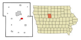
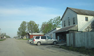
Chapin is an unincorporated community and census-designated place in northern Franklin County, Iowa, United States. It lies along local roads just off U.S. Route 65, north of the city of Hampton, the county seat of Franklin County. Its elevation is 1,155 feet (352 m), and it is located at 42°50′1″N93°13′20″W. Although Chapin is unincorporated, it has a post office with the ZIP code of 50427, which opened on 29 February 1860. As of the 2020 census, its population was 71.

South Amana is an unincorporated community and census-designated place (CDP) in northern Iowa County, Iowa, United States, and is part of the "seven villages" of the Amana Colonies. As of the 2020 census, it had a population of 165.

Conroy is an unincorporated community and census-designated place (CDP) in central Iowa County, Iowa, United States. It lies along local roads southeast of the city of Marengo, the county seat of Iowa County. Its elevation is 879 feet (268 m). Conroy has a post office with the ZIP Code of 52220, which opened on 5 January 1885. As of the 2020 census the population was 252.

Little Cedar is an unincorporated community and census-designated place in central Mitchell County, Iowa, United States. As of the 2020 census it had a population of 64. Little Cedar has a post office with the ZIP code of 50454.

<span class="mw-page-title-main">Toeterville, Iowa</span> Census-designated place in Iowa, United States

Toeterville is an unincorporated community and census-designated place in northwestern Mitchell County, Iowa, United States. As of the 2020 census it had a population of 53.

<span class="mw-page-title-main">Argyle, Iowa</span> Unincorporated community in Iowa, United States

Argyle is an unincorporated community in southwestern Lee County, Iowa, United States. As of the 2020 census, its population was 91.

Burchinal is an unincorporated community and census-designated place in Cerro Gordo County, Iowa, United States. As of the 2020 census, its population was 33.

New Haven is an unincorporated community and census-designated place in Mitchell County, Iowa, United States. As of the 2020 census the population of New Haven was 77.

East Amana is an unincorporated community and census-designated place (CDP) in Iowa County, Iowa, United States, and is part of the "seven villages" of the Amana Colonies. As of the 2020 Census, the population of East Amana was 64.

Corley is an unincorporated community and census-designated place in Shelby County, Iowa, in the United States. As of the 2020 Census the population of Corley was 31.

Jacksonville is an unincorporated community and census-designated place in Jackson Township, Shelby County, Iowa, in the United States. As of the 2020 Census the population of Jacksonville was 29.

Hutchins is an unincorporated community and census-designated place in Hancock County, Iowa, United States. As of the 2020 census the population was 22.

Portland is an unincorporated community and census-designated place (CDP) in Portland Township, Cerro Gordo County, Iowa, United States. As of the 2020 census it had a population of 28.

<span class="mw-page-title-main">Plainview, Iowa</span> Census-designated place in Iowa, United States

Plainview is an unincorporated community and census-designated place in Cleona and Hickory Grove Townships, Scott County, Iowa, United States. Plainview is located along Iowa Highway 130 5.7 miles (9.2 km) north of Walcott.

<span class="mw-page-title-main">Argo, Iowa</span> Census-designated place in Iowa, United States

Argo is an unincorporated community and census-designated place (CDP) in Scott County, Iowa, United States. It is in the eastern part of the county, 9 miles (14 km) northeast of Bettendorf and 5 miles (8 km) northwest of Le Claire.

References

  1. "2020 U.S. Gazetteer Files". United States Census Bureau. Retrieved March 16, 2022.
  2. USPS – Cities by ZIP Code Archived 2011-05-17 at the Wayback Machine
  3. "Census of Population and Housing". Census.gov. Retrieved June 4, 2016.
  4. "2020 Census". United States Census Bureau.
  5. "A tribute to those little places from the past that are no more: like Odd, Dodds, Wolfdale, Lozier". Moville Record. October 16, 2003. p. 1. Retrieved November 3, 2015.
  6. U.S. Geological Survey Geographic Names Information System: Climbing Hill, Iowa, Geographic Names Information System, 1979-04-30. Accessed 2008-04-08.
  7. Cram's Modern Atlas: The New Unrivaled New Census Edition. J. R. Gray & Company. 1902. pp. 203–207.
  8. Premier Atlas of the World: Containing Maps of All Countries of the World, with the Most Recent Boundary Decisions, and Maps of All the States,territories, and Possessions of the United States with Population Figures from the Latest Official Census Reports, Also Data of Interest Concerning International and Domestic Political Questions. Rand McNally & Company. 1925. p. 190.
  9. The Attorneys List. United States Fidelity and Guaranty Company, Attorney List Department. 1940. p. 296.