Elk Point, South Dakota

Last updated

Elk Point
Downtown Elk Point.JPG
Main Street in Elk Point and some of the businesses located there
Union County South Dakota Incorporated and Unincorporated areas Elk Point Highlighted.svg
Location in Union County and the state of South Dakota
Coordinates: 42°40′52″N96°40′50″W / 42.68111°N 96.68056°W / 42.68111; -96.68056
CountryUnited States
State South Dakota
County Union
Incorporated January 10, 1873 [1]
Government
   Mayor Deb McCreary
Area
[2]
  Total1.55 sq mi (4.01 km2)
  Land1.55 sq mi (4.01 km2)
  Water0.00 sq mi (0.00 km2)
Elevation
[3]
1,125 ft (343 m)
Population
 (2020) [4]
  Total2,149
  Estimate 
(2022) [5]
2,103
  Density1,387.35/sq mi (535.79/km2)
Time zone UTC–6 (Central (CST))
  Summer (DST) UTC–5 (CDT)
ZIP code
57025
Area code 605
FIPS code 46-18620
GNIS feature ID1267378 [3]
Sales tax 6.2% [6]
Website elkpoint.org

Elk Point is a city in and county seat of Union County, South Dakota, United States. The population was 2,149 as of the 2020 census. [4]

Contents

History

The British established a Hudson's Bay Company trading post in 1755 near present-day Elk Point. [7] Elk Point was so named on account of the abundant elk in the area. [8] The town was incorporated in 1873. [9]

Geography

According to the United States Census Bureau, the city has a total area of 1.36 square miles (3.52 km2), all land. [10]

Demographics

Historical population
CensusPop.Note
1900 1,081
1910 1,20011.0%
1920 1,47022.5%
1930 1,294−12.0%
1940 1,48314.6%
1950 1,367−7.8%
1960 1,3780.8%
1970 1,372−0.4%
1980 1,66121.1%
1990 1,423−14.3%
2000 1,71420.4%
2010 1,96314.5%
2020 2,1499.5%
2022 (est.)2,103 [5] −2.1%
U.S. Decennial Census [11]
2020 Census [4]

It is part of the Sioux City, IA-NE-SD Metropolitan Statistical Area.

2010 census

As of the census of 2010, there were 1,963 people, 770 households, and 505 families living in the city. The population density was 1,443.4 inhabitants per square mile (557.3/km2). There were 830 housing units at an average density of 610.3 per square mile (235.6/km2). The racial makeup of the city was 97.0% White, 0.3% African American, 0.6% Native American, 0.2% Asian, 0.8% from other races, and 1.2% from two or more races. Hispanic or Latino of any race were 1.5% of the population.

There were 770 households, of which 37.5% had children under the age of 18 living with them, 51.9% were married couples living together, 8.4% had a female householder with no husband present, 5.2% had a male householder with no wife present, and 34.4% were non-families. 30.8% of all households were made up of individuals, and 15% had someone living alone who was 65 years of age or older. The average household size was 2.49 and the average family size was 3.16.

The median age in the city was 36.3 years. 30.4% of residents were under the age of 18; 4.9% were between the ages of 18 and 24; 25.7% were from 25 to 44; 25% were from 45 to 64; and 14% were 65 years of age or older. The gender makeup of the city was 48.0% male and 52.0% female.

2000 census

As of the census of 2000, there were 1,714 people, 682 households, and 459 families living in the city. The population density was 1,276.0 inhabitants per square mile (492.7/km2). There were 750 housing units at an average density of 558.4 per square mile (215.6/km2). The racial makeup of the city was 98.54% White, 0.18% African American, 0.23% Native American, 0.35% Asian, 0.18% from other races, and 0.53% from two or more races. Hispanic or Latino of any race were 0.93% of the population.

There were 682 households, out of which 33.6% had children under the age of 18 living with them, 56.2% were married couples living together, 7.5% had a female householder with no husband present, and 32.6% were non-families. 28.6% of all households were made up of individuals, and 14.1% had someone living alone who was 65 years of age or older. The average household size was 2.43 and the average family size was 3.00.

In the city, the population was spread out, with 26.7% under the age of 18, 8.7% from 18 to 24, 27.8% from 25 to 44, 21.4% from 45 to 64, and 15.5% who were 65 years of age or older. The median age was 36 years. For every 100 females, there were 93.5 males. For every 100 females age 18 and over, there were 90.5 males.

As of 2000, the median income for a household in the city was $41,157, and the median income for a family was $48,056. Males had a median income of $35,509 versus $22,885 for females. The per capita income for the city was $18,153. About 5.5% of families and 7.4% of the population were below the poverty line, including 8.1% of those under age 18 and 8.4% of those age 65 or over.

Education

Elk Point Public Schools are part of the Elk Point-Jefferson School District (South Dakota). The school district has one elementary school, one middle school, and one high school. Students attend Elk Point-Jefferson High School. [12]

Notable person

See also

Related Research Articles

<span class="mw-page-title-main">Union County, South Dakota</span> County in South Dakota, United States

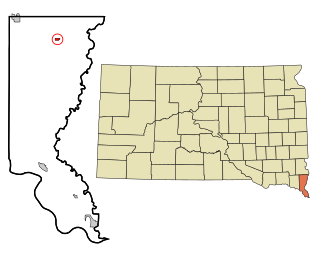
Union County is the southernmost county in the U.S. state of South Dakota. As of the 2020 census, the population was 16,811, making it the 13th most populous county in South Dakota. Its county seat has been Elk Point since April 30, 1865. Originally named Cole County, its name was changed to Union on January 7, 1864, because of Civil War sentiment.

<span class="mw-page-title-main">South Sioux City, Nebraska</span> City in Dakota County, Nebraska, United States

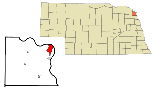
South Sioux City is a city in Dakota County, Nebraska, United States. It is located immediately across the Missouri River from Sioux City, Iowa, and is part of the Sioux City, IA-NE-SD Metropolitan Statistical Area. As of the 2010 census, the city population was 13,353, making it the 14th most populous city in Nebraska.

<span class="mw-page-title-main">Lake Andes, South Dakota</span> City in South Dakota, United States

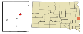
Lake Andes is a city in, and the county seat of, Charles Mix County, South Dakota, United States. The population was 710 at the 2020 census.

<span class="mw-page-title-main">Marty, South Dakota</span> CDP in South Dakota, United States

Marty is a census-designated place (CDP) in southern Charles Mix County, South Dakota, United States. The population was 677 at the 2020 census.

<span class="mw-page-title-main">Webster, South Dakota</span> City in South Dakota, United States

Webster is a city in and the county seat of Day County, South Dakota, United States. The population was 1,728 at the 2020 census.

<span class="mw-page-title-main">Edgemont, South Dakota</span> City in South Dakota, United States

Edgemont is a city in Fall River County, South Dakota, United States. The population was 725 at the 2020 census. The city lies on the far southern edge of the Black Hills in southwestern South Dakota.

<span class="mw-page-title-main">Lennox, South Dakota</span> City in South Dakota, United States

Lennox is a city in Lincoln County, South Dakota, United States, located 20 miles (32 km) southwest of Sioux Falls. The population was 2,423 at the 2020 census.

<span class="mw-page-title-main">Tea, South Dakota</span> City in South Dakota, United States

Tea is a city in Lincoln County, South Dakota, United States and is a suburb of Sioux Falls. The population was 5,598 at the 2020 census.

<span class="mw-page-title-main">Faith, South Dakota</span> City in South Dakota, United States

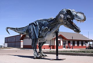
Faith is a city in the northeastern corner of Meade County, South Dakota, United States. The population was 367 at the 2020 census. The most complete Tyrannosaurus rex skeleton known, Sue, was discovered approximately 15 miles (24 km) northeast of Faith in August 1990.

<span class="mw-page-title-main">Baltic, South Dakota</span> City in South Dakota, United States

Baltic is a city on the Big Sioux River in northern Minnehaha County, South Dakota, United States. The population was 1,246 at the 2020 census.

<span class="mw-page-title-main">Dell Rapids, South Dakota</span> City in South Dakota, United States

Dell Rapids is a city in Minnehaha County, South Dakota, United States. The population was 3,996 at the 2020 census. It is known as "The Little City with the Big Attractions."

<span class="mw-page-title-main">Hartford, South Dakota</span> City in South Dakota, United States

Hartford is a suburban American city in Minnehaha County, South Dakota, a few miles northwest of Sioux Falls. Its population was 3,354 at the 2020 census.

<span class="mw-page-title-main">Flandreau, South Dakota</span> City in South Dakota, United States

FlandreauFLAN-droo is a city in and county seat of Moody County, South Dakota, United States. The population was 2,372 at the 2020 census. It was named in honor of Charles Eugene Flandrau, a judge in the territory and state of Minnesota. He is credited with saving the community of New Ulm, Minnesota, from destruction during conflict with the Sioux tribe in 1862.

<span class="mw-page-title-main">Sisseton, South Dakota</span> City in South Dakota, United States

Sisseton is a city in Roberts County, South Dakota, United States. The population was 2,479 at the 2020 census. It is the county seat of Roberts County. Sisseton is the home to a number of tourist attractions, including the Nicollet Tower, and is near the "Song to the Great Spirit" building on the Sisseton Wahpeton College campus. The city is named for the Sisseton division of the Native American Sioux. It also serves as an important part of the Lake Traverse Indian Reservation.

<span class="mw-page-title-main">Mission, South Dakota</span> City in South Dakota, United States

Mission is a city on the Rosebud Indian Reservation in northern Todd County, South Dakota, United States. The population was 1,156 at the 2020 census.

<span class="mw-page-title-main">Alcester, South Dakota</span> City in South Dakota, United States

Alcester is a city in northern Union County, South Dakota, United States. It is part of the Sioux City, IA–NE–SD Metropolitan Statistical Area. The population was 820 at the 2020 census.

<span class="mw-page-title-main">Jefferson, South Dakota</span> City in South Dakota, United States

Jefferson is a city in Union County, South Dakota, United States. The population was 475 at the 2020 census. It is part of the Sioux City, IA-NE-SD Metropolitan Statistical Area. Jefferson was founded in 1859. Every year the citizens of Jefferson and surrounding area celebrate the founding of Jefferson during the "Days of '59", a festival that includes softball, basketball, horseshoes, car show, fireworks and parade.

<span class="mw-page-title-main">North Sioux City, South Dakota</span> City in South Dakota, United States

North Sioux City is a city in Union County, South Dakota, United States. The population was 3,042 at the 2020 census. It is part of the Sioux City, IA-NE-SD Metropolitan Statistical Area.

<span class="mw-page-title-main">Irene, South Dakota</span> City in South Dakota, United States

Irene is a city in Clay, Turner, and Yankton counties in South Dakota, United States. The population was 422 at the 2020 census. The portion of Irene that is located in Turner County is a part of the Sioux Falls, South Dakota metropolitan area, the portion located in Yankton County is part of the Yankton Micropolitan Statistical Area, and the portion located in Clay County is part of both the Vermillion Micropolitan Statistical Area and the Sioux City-Vermillion Combined Statistical Area. Irene is also host to the Irene Rodeo, held every summer.

<span class="mw-page-title-main">Eagle Butte, South Dakota</span> City in South Dakota, United States

Eagle Butte is a city in Dewey and Ziebach counties in South Dakota, United States. The population was 1,258 at the 2020 census.

References

  1. "SD Towns" (PDF). South Dakota State Historical Society. Archived from the original (PDF) on February 10, 2010. Retrieved February 11, 2010.
  2. "2020 U.S. Gazetteer Files". United States Census Bureau. Retrieved July 24, 2022.
  3. 1 2 U.S. Geological Survey Geographic Names Information System: Elk Point, South Dakota
  4. 1 2 3 "Explore Census Data". United States Census Bureau . Retrieved January 8, 2024.
  5. 1 2 "City and Town Population Totals: 2020-2022". United States Census Bureau. January 8, 2024. Retrieved January 8, 2024.
  6. "Elk Point (SD) sales tax rate" . Retrieved January 8, 2024.
  7. Hogan, Edward Patrick; Fouberg, Erin Hogan (2001). The Geography of South Dakota (Third ed.). Sioux Falls, SD: The Center for Western Studies – Augustana College. ISBN   0-931170-79-6.
  8. Federal Writers' Project (1940). South Dakota place-names, v.1-3. University of South Dakota. p. 36. Archived from the original on August 9, 2016.
  9. "Elk Point, South Dakota". City-Data.com. Retrieved July 28, 2012.
  10. "US Gazetteer files 2010". United States Census Bureau. Archived from the original on January 25, 2012. Retrieved June 21, 2012.
  11. United States Census Bureau. "Census of Population and Housing" . Retrieved September 23, 2013.
  12. "Elk Point-Jefferson School District". Elk Point-Jefferson School District. Retrieved July 28, 2012.