Fort Pierre, South Dakota

Last updated
Fort Pierre
FtPierre main.jpg
Main and Deadwood streets in Fort Pierre, South Dakota
Motto: 
"Where The West Begins"
Stanley County South Dakota Incorporated and Unincorporated areas Fort Pierre Highlighted.svg
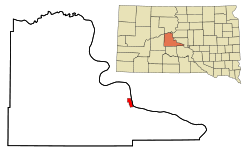
Location in Stanley County and the state of South Dakota
Coordinates: 44°22′04″N100°22′59″W / 44.36778°N 100.38306°W / 44.36778; -100.38306
CountryUnited States
State South Dakota
County Stanley
Founded1867
Incorporated June 2, 1890 [1]
Government
   Mayor Gloria Hanson
Area
[2]
  Total3.17 sq mi (8.20 km2)
  Land3.12 sq mi (8.08 km2)
  Water0.05 sq mi (0.12 km2)
Elevation
[3]
1,440 ft (439 m)
Population
 (2020) [4]
  Total2,115
  Estimate 
(2022) [5]
2,142
  Density678.10/sq mi (261.84/km2)
Time zone UTC–7 (Mountain (MST))
  Summer (DST) UTC–6 (MDT)
ZIP code
57532
Area code 605
FIPS code 46-22260
GNIS feature ID1267393 [3]
Website fortpierre.com

Fort Pierre is a city in Stanley County, South Dakota, United States. It is part of the Pierre, South Dakota micropolitan area and the county seat of Stanley County. The population was 2,115 at the 2020 census. [4]

Contents

The settlement of Fort Pierre developed around an 1832 trading post and fort situated on the west bank of the Missouri River, near the confluence with its tributary Bad River. An earlier American-owned trading post had been operating nearby since 1817, and in 2017 the city celebrated its bicentennial of continuous permanent settlement.

History

On March 30, 1743, Francois and Louis-Joseph Gaultier de La Vérendrye reached the area of present-day Fort Pierre during an expedition west from Quebec, a French colony in present-day Canada. [6] They left a lead plate buried in a hill to claim the land for the King of France. [7] In the 1803 Louisiana Purchase, the United States acquired this area and the remainder of France's vast territory west of the Mississippi River.

President Thomas Jefferson commissioned the Lewis and Clark Corps of Discovery Expedition in 1804 to explore the territory, especially by traveling west to the Upper Missouri and Platte rivers, in the hope of finding a water route to the Pacific Ocean. They met with the Teton Sioux on the south side of the mouth of the Bad River on September 24-28, 1804.

In 1817 fur trader Joseph La Framboise, Jr., an agent for the American Fur Company, established Fort Tecumseh a mile to the north, on what is now La Framboise Island in the Missouri River. The fur trade was highly lucrative and attracted competitors. In 1832, Pierre Chouteau, Jr., a major fur trader from St Louis, replaced that early facility with Fort Pierre Chouteau, a trading post and fort on the west side of the Missouri and north side of the Bad River's mouth.

The city of Fort Pierre gradually developed around the trading post. Fort Pierre celebrated its Bicentennial in 2017, marking 200 years of continuous permanent settlement at the confluence of the Missouri and Bad rivers.

In 1880, the settlement of Pierre was founded on the east side of the Missouri River in Hughes. Because it was centrally located and reached first by the railroad, it was designated by the state legislature as the state capital when South Dakota was admitted as a state.

Geography

Across the Missouri River from Fort Pierre is the state capital of South Dakota, Pierre.

According to the United States Census Bureau, the city has a total area of 3.16 square miles (8.18 km2), of which 3.11 square miles (8.05 km2) is land and 0.05 square miles (0.13 km2) is water. [8]

Although Fort Pierre is located in the Mountain Time Zone, most residents of the city use Central Time because of close social and economic ties with Pierre, which is located in the Central Time Zone.

Demographics

Historical population
CensusPop.Note
1880 287
1890 36025.4%
1900 3959.7%
1910 792100.5%
1920 8051.6%
1930 683−15.2%
1940 76411.9%
1950 95124.5%
1960 2,649178.5%
1970 1,448−45.3%
1980 1,78923.5%
1990 1,8543.6%
2000 1,9917.4%
2010 2,0784.4%
2020 2,1151.8%
2022 (est.)2,142 [5] 1.3%
U.S. Decennial Census [9]
2020 Census [4]
Fort Pierre and the adjacent prairie circa 1833. Fort Pierre on the Missouri: aquatint by Karl Bodmer from the book Maximilian, Prince of Wied's Travels in the Interior of North America, during the years 1832-1834 Karl Bodmer Travels in America (43).jpg
Fort Pierre and the adjacent prairie circa 1833. Fort Pierre on the Missouri: aquatint by Karl Bodmer from the book Maximilian, Prince of Wied’s Travels in the Interior of North America, during the years 1832–1834

2010 census

As of the census of 2010, there were 2,078 people, 893 households, and 586 families living in the city. The population density was 668.2 inhabitants per square mile (258.0/km2). There were 959 housing units at an average density of 308.4 per square mile (119.1/km2). The racial makeup of the city was 89.4% White, 0.3% African American, 6.6% Native American, 0.2% Asian, 0.2% from other races, and 3.3% from two or more races. Hispanic or Latino of any race were 0.7% of the population.

There were 893 households, of which 30.5% had children under the age of 18 living with them, 51.6% were married couples living together, 9.7% had a female householder with no husband present, 4.3% had a male householder with no wife present, and 34.4% were non-families. 30.6% of all households were made up of individuals, and 11.2% had someone living alone who was 65 years of age or older. The average household size was 2.33 and the average family size was 2.86.

The median age in the city was 41.8 years. 24.1% of residents were under the age of 18; 6.6% were between the ages of 18 and 24; 23.2% were from 25 to 44; 30% were from 45 to 64; and 16% were 65 years of age or older. The gender makeup of the city was 49.4% male and 50.6% female.

2000 census

As of the census of 2000, there were 1,991 people, 810 households, and 538 families living in the city. The population density was 686.6 inhabitants per square mile (265.1/km2). There were 875 housing units at an average density of 301.8 per square mile (116.5/km2). The racial makeup of the city was 92.16% White, 0.20% African American, 5.22% Native American, 0.30% Asian, 0.15% from other races, and 1.96% from two or more races. Hispanic or Latino of any race were 0.40% of the population.

There were 810 households, out of which 34.3% had children under the age of 18 living with them, 51.4% were married couples living together, 10.9% had a female householder with no husband present, and 33.5% were non-families. 28.4% of all households were made up of individuals, and 8.9% had someone living alone who was 65 years of age or older. The average household size was 2.45 and the average family size was 3.01.

In the city, the population was spread out, with 28.0% under the age of 18, 6.9% from 18 to 24, 28.3% from 25 to 44, 25.4% from 45 to 64, and 11.3% who were 65 years of age or older. The median age was 37 years. For every 100 females, there were 99.9 males. For every 100 females age 18 and over, there were 95.8 males.

As of 2000 the median income for a household in the city was $41,181, and the median income for a family was $47,885. Males had a median income of $29,948 versus $21,208 for females. The per capita income for the city was $20,478. About 7.4% of families and 8.9% of the population were below the poverty line, including 12.2% of those under age 18 and 14.8% of those age 65 or over.

Climate

The data here are for a weather station 17 miles west-southwest of Fort Pierre, near Wendte. Fort Pierre's reading of 120 °F is tied for the highest temperature recorded in the state of South Dakota (the other occurrence of 120 °F was at Gann Valley in 1934). [10]

Climate data for Fort Pierre, SD
MonthJanFebMarAprMayJunJulAugSepOctNovDecYear
Record high °F (°C)75
(24)
76
(24)
88
(31)
99
(37)
105
(41)
111
(44)
120
(49)
111
(44)
110
(43)
101
(38)
87
(31)
75
(24)
120
(49)
Mean daily maximum °F (°C)33.5
(0.8)
38.6
(3.7)
49.9
(9.9)
62.5
(16.9)
72.8
(22.7)
82.5
(28.1)
90.3
(32.4)
90.1
(32.3)
80.6
(27.0)
64.4
(18.0)
47.7
(8.7)
35.0
(1.7)
62.3
(16.8)
Mean daily minimum °F (°C)8.2
(−13.2)
12.8
(−10.7)
23.2
(−4.9)
34.1
(1.2)
45.2
(7.3)
55.5
(13.1)
61.5
(16.4)
59.4
(15.2)
48.5
(9.2)
35.0
(1.7)
21.3
(−5.9)
10.7
(−11.8)
34.6
(1.5)
Record low °F (°C)−44
(−42)
−47
(−44)
−26
(−32)
2
(−17)
19
(−7)
32
(0)
43
(6)
37
(3)
18
(−8)
−3
(−19)
−16
(−27)
−40
(−40)
−47
(−44)
Average precipitation inches (mm)0.34
(8.6)
0.51
(13)
1.08
(27)
1.99
(51)
2.53
(64)
2.78
(71)
2.19
(56)
1.66
(42)
1.41
(36)
1.33
(34)
0.53
(13)
0.37
(9.4)
16.72
(425)
Average snowfall inches (cm)5.2
(13)
6.1
(15)
5.7
(14)
3.2
(8.1)
0.1
(0.25)
0
(0)
0
(0)
0
(0)
0
(0)
0.8
(2.0)
3.5
(8.9)
4.8
(12)
29.4
(73.25)
Source: http://www.wrcc.dri.edu/cgi-bin/cliMAIN.pl?sd3076

Media

AM Radio

FM Radio

Television

The Capital Journal is the local newspaper.

Notable people

Related Research Articles

<span class="mw-page-title-main">Pierre, South Dakota</span> Capital city of South Dakota, United States

Pierre is the capital city of the U.S. state of South Dakota and the seat of Hughes County. The population was 14,091 at the 2020 census, making it the 2nd least populous US state capital after Montpelier, Vermont. It is South Dakota's 9th most populous city. Founded in 1880 on the Missouri River near the center of South Dakota, it was selected as the state capital when the territory was admitted as a state. Pierre is the principal city of the Pierre Micropolitan Statistical Area, which includes all of Hughes and Stanley counties.

<span class="mw-page-title-main">Stanley County, South Dakota</span> County in South Dakota, United States

Stanley County is a county in the U.S. state of South Dakota. As of the 2020 census, the population was 2,980. Its county seat is Fort Pierre. The county was created in 1873, and was organized in 1890. It is named for David S. Stanley, a commander at Fort Sully from 1866 to 1874, which was located nearby.

<span class="mw-page-title-main">Hughes County, South Dakota</span> County in South Dakota, United States

Hughes County is a county in the U.S. state of South Dakota. As of the 2020 census, the population was 17,765, making it the least populous capital county in the nation, and the 12th most populous county in South Dakota. Its county seat is Pierre, which is also the state capital. The county was created in 1873, and was organized in 1880. It was named for Alexander Hughes, a legislator. On June 4, 1891, the county's area was increased by the addition of Farm Island, in the Missouri River downstream of Pierre.

<span class="mw-page-title-main">Mayes County, Oklahoma</span> County in Oklahoma, United States

Mayes County is a county located in the U.S. state of Oklahoma. As of the 2020 census, the population was 39,046. Its county seat is Pryor Creek. Named for Samuel Houston Mayes, Principal Chief of the Cherokee Nation from 1895 to 1899, it was originally created at the Sequoyah Convention in August 1905.

<span class="mw-page-title-main">Chouteau County, Montana</span> County in Montana, United States

Chouteau County is a county located in the North-Central region of the U.S. state of Montana. As of the 2020 census, the population was 5,895. Its county seat is Fort Benton. The county was established in 1865 as one of the original nine counties of Montana, and named in 1882 after Pierre Chouteau Jr., a fur trader who established a trading post that became Fort Benton, which was once an important port on the Missouri River.

<span class="mw-page-title-main">Fort Benton, Montana</span> City in Montana, United States

Fort Benton is a city in and the county seat of Chouteau County, Montana, United States. Established in 1846, Fort Benton is the oldest continuously occupied settlement in Montana. Fort Benton was the most upstream navigable port on the Mississippi River System, and is considered "the world’s innermost port".

<span class="mw-page-title-main">Loma, Montana</span> Census-designated place in Montana, United States

Loma is a census-designated place (CDP) in Chouteau County, Montana, United States. The population was 85 at the 2010 census.

<span class="mw-page-title-main">Choteau, Montana</span> City in Montana, United States

Choteau is a city in and the county seat of Teton County, Montana, United States. The population was 1,721 at the 2020 census.

<span class="mw-page-title-main">Fort Ransom, North Dakota</span> City in North Dakota, United States

Fort Ransom is a city in Ransom County, North Dakota, United States. The population was 91 at the 2020 census. Fort Ransom was founded in 1880 with the first merchants arriving in 1878.

<span class="mw-page-title-main">Fort Yates, North Dakota</span> City in Standing Rock Indian Reservation, United States

Fort Yates is a city in Sioux County, North Dakota, United States. It is the tribal headquarters of the Standing Rock Sioux Tribe and county seat of Sioux County. Since 1970 the population has declined markedly from more than 1,100 residents, as people have left for other locations for work. The population was 176 at the 2020 census.

<span class="mw-page-title-main">Springfield, South Dakota</span> City in South Dakota, United States

Springfield is a city in Bon Homme County, South Dakota, United States. The population was 1,914 at the 2020 census. As of 2023, about 1,250 of the residents were inmates at Mike Durfee State Prison.

<span class="mw-page-title-main">Chamberlain, South Dakota</span> City in South Dakota, United States

Chamberlain is a city in Brule County, South Dakota, United States. It is located on the east bank of the Missouri River, at the dammed section of the Lake Francis Case, close to where it is crossed by Interstate 90.

<span class="mw-page-title-main">Pickstown, South Dakota</span> Town in South Dakota, United States

Pickstown is a town in southern Charles Mix County, South Dakota, United States. The population was 230 at the 2020 census. It was named after U.S. Army General Lewis A. Pick, former director of the Missouri River Office of the United States Army Corps of Engineers.

<span class="mw-page-title-main">La Plant, South Dakota</span> Census-designated place in South Dakota, United States

La Plant is a census-designated place (CDP) in Dewey County, South Dakota, United States. The population was 167 at the 2020 census. It is within the Cheyenne River Indian Reservation.

<span class="mw-page-title-main">Philip, South Dakota</span> City in South Dakota, United States

Philip is a town in and the county seat of rural Haakon County, South Dakota, United States. The population was 759 at the 2020 census.

<span class="mw-page-title-main">De Smet, South Dakota</span> Town in South Dakota, United States

De Smet is a city in and the county seat of Kingsbury County, South Dakota, United States. The population was 1,056 at the 2020 census.

<span class="mw-page-title-main">Reliance, South Dakota</span> Town in South Dakota, United States

Reliance is a town in Lyman County, South Dakota, United States. The population was 128 at the 2020 census.

<span class="mw-page-title-main">Lake City, South Dakota</span> Town in South Dakota, United States

Lake City is a town in Marshall County, South Dakota, United States. The population was 45 at the 2020 census. Fort Sisseton Historic State Park, whose fort is listed on the National Register of Historic Places, is located nearby.

<span class="mw-page-title-main">Faith, South Dakota</span> City in South Dakota, United States

Faith is a city in the northeastern corner of Meade County, South Dakota, United States. The population was 367 at the 2020 census. The most complete Tyrannosaurus rex skeleton known, Sue, was discovered approximately 15 miles (24 km) northeast of Faith in August 1990.

<span class="mw-page-title-main">Mobridge, South Dakota</span> City in South Dakota, United States

Mobridge also Kȟowákataŋ Otȟúŋwahe is a city in Walworth County, South Dakota, United States. The population was 3,261 according to the 2020 census.

References

  1. "SD Towns" (PDF). South Dakota State Historical Society. Archived from the original (PDF) on February 10, 2010. Retrieved February 11, 2010.
  2. "2020 U.S. Gazetteer Files". United States Census Bureau. Retrieved July 24, 2022.
  3. 1 2 U.S. Geological Survey Geographic Names Information System: Fort Pierre, South Dakota
  4. 1 2 3 "Explore Census Data". United States Census Bureau . Retrieved January 8, 2024.
  5. 1 2 "City and Town Population Totals: 2020-2022". United States Census Bureau. January 8, 2024. Retrieved January 8, 2024.
  6. Hogan, Edward Patrick; Fouberg, Erin Hogan (2001). The Geography of South Dakota (Third ed.). Sioux Falls, SD: The Center for Western Studies – Augustana College. ISBN   0-931170-79-6.
  7. "Vérendrye Museum". National Park Service . Retrieved March 12, 2015.
  8. "US Gazetteer files 2010". United States Census Bureau. Archived from the original on July 2, 2012. Retrieved June 21, 2012.
  9. United States Census Bureau. "Census of Population and Housing" . Retrieved October 20, 2014.
  10. Enloe. "State Climate Extremes Committee (SCEC) | Extremes | National Centers for Environmental Information (NCEI)". www.ncdc.noaa.gov. Retrieved December 30, 2017.