Madison, South Dakota

Last updated

Madison, South Dakota
Egan Ave. looking north, Madison, South Dakota (75659).jpg
Motto: 
Discover the Unexpected
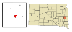
Lake County South Dakota Incorporated and Unincorporated areas Madison Highlighted.svg
Location in Lake County and the state of South Dakota
Usa edcp location map.svg
Red pog.svg
Madison, South Dakota
Location in the United States
Coordinates: 44°0′28″N97°6′53″W / 44.00778°N 97.11472°W / 44.00778; -97.11472
Country United States
State South Dakota
County Lake
Founded1880
Incorporated1885 [1]
Government
  MayorRoy Lindsay [2]
Area
[3]
  Total4.62 sq mi (11.95 km2)
  Land4.62 sq mi (11.95 km2)
  Water0.00 sq mi (0.00 km2)
Elevation
[4]
1,673 ft (510 m)
Population
 (2020) [5]
  Total6,191
  Density1,341.20/sq mi (517.87/km2)
Time zone UTC−6 (Central)
  Summer (DST) UTC−5 (CDT)
Zip code
57042
Area code 605
FIPS code 46-40220 [6]
GNIS feature ID1267469 [4]
Website www.cityofmadisonsd.com

Madison is a city in Lake County, South Dakota, United States. The population was 6,191 at the 2020 census. [7] It is the county seat of Lake County [8] and is home to Dakota State University.

Contents

Geography

Madison is located in the center of Lake County in southeastern South Dakota, 31 miles (50 km) northwest of Sioux Falls, 21 miles (34 km) southwest of Brookings, and 157 miles (253 km) east of Pierre. It is situated between Lake Herman and Lake Madison.

Two small streams flow through Madison named Silver Creek and Park Creek. Although rarely, these creeks are known to flood after heavy rain events. [9]

According to the United States Census Bureau, the city has a total area of 4.61 square miles (11.94 km2), all land. [10]

Climate

Climate data for Madison 2SE, South Dakota (1991−2020 normals, extremes 1961−present)
MonthJanFebMarAprMayJunJulAugSepOctNovDecYear
Record high °F (°C)66
(19)
68
(20)
84
(29)
94
(34)
98
(37)
105
(41)
104
(40)
104
(40)
102
(39)
89
(32)
80
(27)
64
(18)
105
(41)
Mean maximum °F (°C)45.5
(7.5)
50.1
(10.1)
66.3
(19.1)
80.1
(26.7)
87.2
(30.7)
92.6
(33.7)
94.0
(34.4)
93.1
(33.9)
88.4
(31.3)
82.1
(27.8)
64.7
(18.2)
48.3
(9.1)
96.2
(35.7)
Mean daily maximum °F (°C)23.7
(−4.6)
28.5
(−1.9)
41.2
(5.1)
55.6
(13.1)
68.1
(20.1)
78.2
(25.7)
83.3
(28.5)
80.9
(27.2)
73.1
(22.8)
58.7
(14.8)
42.2
(5.7)
28.7
(−1.8)
55.2
(12.9)
Daily mean °F (°C)14.4
(−9.8)
19.0
(−7.2)
31.4
(−0.3)
44.5
(6.9)
57.0
(13.9)
67.4
(19.7)
72.1
(22.3)
69.7
(20.9)
61.4
(16.3)
47.2
(8.4)
32.4
(0.2)
19.9
(−6.7)
44.7
(7.1)
Mean daily minimum °F (°C)5.0
(−15.0)
9.5
(−12.5)
21.5
(−5.8)
33.4
(0.8)
45.9
(7.7)
56.6
(13.7)
60.9
(16.1)
58.4
(14.7)
49.6
(9.8)
35.7
(2.1)
22.6
(−5.2)
11.0
(−11.7)
34.2
(1.2)
Mean minimum °F (°C)−17.4
(−27.4)
−12.3
(−24.6)
−3.2
(−19.6)
16.1
(−8.8)
30.4
(−0.9)
43.0
(6.1)
47.8
(8.8)
45.2
(7.3)
31.6
(−0.2)
18.2
(−7.7)
2.5
(−16.4)
−11.9
(−24.4)
−20.9
(−29.4)
Record low °F (°C)−33
(−36)
−31
(−35)
−23
(−31)
1
(−17)
17
(−8)
35
(2)
39
(4)
35
(2)
22
(−6)
4
(−16)
−17
(−27)
−31
(−35)
−33
(−36)
Average precipitation inches (mm)0.46
(12)
0.66
(17)
1.03
(26)
2.70
(69)
3.74
(95)
4.24
(108)
3.33
(85)
3.38
(86)
3.21
(82)
2.16
(55)
0.85
(22)
0.61
(15)
26.37
(670)
Average snowfall inches (cm)5.6
(14)
8.4
(21)
5.0
(13)
4.2
(11)
0.1
(0.25)
0.0
(0.0)
0.0
(0.0)
0.0
(0.0)
0.0
(0.0)
0.8
(2.0)
4.9
(12)
7.8
(20)
36.8
(93)
Average precipitation days (≥ 0.01 in)4.55.45.49.111.511.48.87.97.46.64.34.787.0
Average snowy days (≥ 0.1 in)3.54.32.31.30.00.00.00.00.00.61.83.617.4
Source: NOAA [11] [12]

Demographics

Historical population
CensusPop.Note
1880 96
1890 1,7361,708.3%
1900 2,55046.9%
1910 3,13723.0%
1920 4,14432.1%
1930 4,2893.5%
1940 5,01817.0%
1950 5,1532.7%
1960 5,4205.2%
1970 6,31516.5%
1980 6,210−1.7%
1990 6,2570.8%
2000 6,5404.5%
2010 6,474−1.0%
2020 6,191−4.4%
U.S. Decennial Census [13]
2017 Estimate [14] [5]

2010 census

As of the census [15] of 2010, there were 6,474 people, 2,627 households, and 1,449 families living in the city. The population density was 1,404.3 inhabitants per square mile (542.2/km2). There were 2,848 housing units at an average density of 617.8 per square mile (238.5/km2). The racial makeup of the city was 94.5% White, 0.7% African American, 0.9% Native American, 1.1% Asian, 1.3% from other races, and 1.5% from two or more races. Hispanic or Latino of any race were 2.4% of the population.

There were 2,627 households, of which 26.5% had children under the age of 18 living with them, 42.6% were married couples living together, 9.4% had a female householder with no husband present, 3.2% had a male householder with no wife present, and 44.8% were non-families. 37.3% of all households were made up of individuals, and 14.2% had someone living alone who was 65 years of age or older. The average household size was 2.22 and the average family size was 2.93.

The median age in the city was 34.6 years. 20.6% of residents were under the age of 18; 18.1% were between the ages of 18 and 24; 20.4% were from 25 to 44; 23.6% were from 45 to 64; and 17.3% were 65 years of age or older. The gender makeup of the city was 49.8% male and 50.2% female.

2000 census

As of the census [6] of 2000, there were 6,540 people, 2,589 households, and 1,491 families living in the city. The population density was 1,529.4 inhabitants per square mile (590.5/km2). There were 2,706 housing units at an average density of 632.8 per square mile (244.3/km2). The racial makeup of the city was 97.16% White, 0.24% African American, 0.81% Native American, 0.76% Asian, 0.02% Pacific Islander, 0.40% from other races, and 0.61% from two or more races. Hispanic or Latino of any race were 0.92% of the population.

There were 2,589 households, out of which 26.6% had children under the age of 18 living with them, 47.2% were married couples living together, 7.5% had a female householder with no husband present, and 42.4% were non-families. 34.8% of all households were made up of individuals, and 16.7% had someone living alone who was 65 years of age or older. The average household size was 2.26 and the average family size was 2.94.

In the city, the population was spread out, with 21.3% under the age of 18, 21.0% from 18 to 24, 21.7% from 25 to 44, 17.4% from 45 to 64, and 18.6% who were 65 years of age or older. The median age was 33 years. For every 100 females, there were 93.7 males. For every 100 females age 18 and over, there were 93.2 males.

As of 2000 the median income for a household in the city was $30,434, and the median income for a family was $39,745. Males had a median income of $28,408 versus $20,965 for females. The per capita income for the city was $14,767. About 6.3% of families and 11.9% of the population were below the poverty line, including 12.2% of those under age 18 and 7.7% of those age 65 or over.

History

Lake County Court House, shown on a c. 1940 postcard Lake County Court House, Madison, South Dakota (75660).jpg
Lake County Court House, shown on a c. 1940 postcard

Madison was laid out in 1873. [16] The city was named after Madison, Wisconsin. [17]

On May 12, 2022, Madison, along with several other towns in the region, were affected by a destructive derecho.

Transportation

Roads

Railroad

Madison was once served by passenger trains of the Milwaukee Road. The former depot is now listed on the National Register of Historic Places.

Notable people

Politics and courts:

Entertainment:

Athletes:

Academics:

Media

Radio

AM radio

AM radio stations
FrequencyCall signNameFormatOwnerCity
1390 AM KJAM Dakota's Best Classic Hits Alpha Media Madison

FM radio

FM radio stations
FrequencyCall signNameFormatOwner City of license
103.1 FM KJAM-FM Jammin' Country Country Alpha Media Madison

Related Research Articles

<span class="mw-page-title-main">Sanborn County, South Dakota</span> County in South Dakota, United States

Sanborn County is a county in the U.S. state of South Dakota. As of the 2020 census, the population was 2,330. Its county seat and largest city is Woonsocket. The county was created by the Dakota Territorial legislature on May 1, 1883, with land partitioned from Miner County. It was fully organized by July 18, 1883.

<span class="mw-page-title-main">Lake County, South Dakota</span> County in South Dakota, United States

Lake County is a county in the U.S. state of South Dakota. As of the 2020 census, the population was 11,059. Its county seat is Madison. The county was formed in 1873.

<span class="mw-page-title-main">Grant County, South Dakota</span> County in South Dakota, United States

Grant County is a county in the U.S. state of South Dakota. As of the 2020 census, the population was 7,556. The county seat is Milbank. The county was founded in 1873 and organized in 1878. It is named for Ulysses S. Grant, 18th President of the United States.

<span class="mw-page-title-main">Edmunds County, South Dakota</span> County in South Dakota, United States

Edmunds County is a county in the U.S. state of South Dakota. At the 2020 census, the population was 3,986. Its county seat is Ipswich. The county was established in 1873 and organized in 1883. It is named for Newton Edmunds, the second Governor of Dakota Territory.

<span class="mw-page-title-main">White Lake, South Dakota</span> City in South Dakota, United States

White Lake is a city in western Aurora County, South Dakota, United States. The population was 394 at the 2020 census.

<span class="mw-page-title-main">Martin, South Dakota</span> City in South Dakota, United States

Martin is a city and the county seat of Bennett County, South Dakota, United States. The population was 938 at the 2020 census.

<span class="mw-page-title-main">Springfield, South Dakota</span> City in South Dakota, United States

Springfield is a city in Bon Homme County, South Dakota, United States. The population was 1,914 at the 2020 census. As of 2023, about 1,250 of the residents were inmates at Mike Durfee State Prison.

<span class="mw-page-title-main">Tyndall, South Dakota</span> City in South Dakota, United States

Tyndall is a city in and the county seat of Bon Homme County, South Dakota, United States. The population was 1,057 at the 2020 census.

<span class="mw-page-title-main">Chamberlain, South Dakota</span> City in South Dakota, United States

Chamberlain is a city in Brule County, South Dakota, United States. It is located on the east bank of the Missouri River, at the dammed section of the Lake Francis Case, close to where it is crossed by Interstate 90.

<span class="mw-page-title-main">Lake Andes, South Dakota</span> City in South Dakota, United States

Lake Andes is a city in, and the county seat of, Charles Mix County, South Dakota, United States. The population was 710 at the 2020 census.

<span class="mw-page-title-main">Wagner, South Dakota</span> City in South Dakota, United States

Wagner is a city in Charles Mix County, South Dakota, United States. The population was 1,490 at the 2020 census. The city is served by Wagner Municipal Airport as well as YST Transit buses.

<span class="mw-page-title-main">Webster, South Dakota</span> City in South Dakota, United States

Webster is a city in and the county seat of Day County, South Dakota, United States. The population was 1,728 at the 2020 census.

<span class="mw-page-title-main">Clear Lake, South Dakota</span> City in South Dakota, United States

Clear Lake is a city in and the county seat of Deuel County, South Dakota, United States. The population was 1,218 at the 2020 census.

<span class="mw-page-title-main">Big Stone City, South Dakota</span> City in South Dakota, United States

Big Stone City is a city in the northeastern corner of Grant County, South Dakota, United States, that lies between the southern tip of Big Stone Lake and the northern bank of the Whetstone River, and is adjacent to the city of Ortonville, Minnesota. The population was 412 at the 2020 census.

<span class="mw-page-title-main">Lake Norden, South Dakota</span> City in South Dakota, United States

Lake Norden is a city in Hamlin County, South Dakota, United States. It is part of the Watertown, South Dakota Micropolitan Statistical Area. The population was 554 at the 2020 census.

<span class="mw-page-title-main">Wentworth, South Dakota</span> Village in South Dakota, United States

Wentworth is an incorporated village in Lake County, South Dakota, United States. It is the only incorporated village in the state of South Dakota. The population was 181 at the 2020 census.

<span class="mw-page-title-main">Lennox, South Dakota</span> City in South Dakota, United States

Lennox is a city in Lincoln County, South Dakota, United States, located 20 miles (32 km) southwest of Sioux Falls. The population was 2,423 at the 2020 census.

<span class="mw-page-title-main">Lake City, South Dakota</span> Town in South Dakota, United States

Lake City is a town in Marshall County, South Dakota, United States. The population was 45 at the 2020 census. Fort Sisseton Historic State Park, whose fort is listed on the National Register of Historic Places, is located nearby.

<span class="mw-page-title-main">Leola, South Dakota</span> City in South Dakota, United States

Leola is a small city in and the county seat of McPherson County, South Dakota, United States. It was founded on May 1, 1884, and named for Leola Haynes, daughter of one of the town's founders. The population was 434 as of the 2020 census.

<span class="mw-page-title-main">Parker, South Dakota</span> City in South Dakota, U.S.

Parker is a city in Turner County, South Dakota, United States. The population was 1,194 at the 2020 census. It is the county seat of Turner County. Parker is bordered on its eastern side by South Dakota State Highway 19. Its northern side is bordered by South Dakota State Highway 44. Parker is located approximately 8 miles (13 km) northwest of Chancellor, 42 miles (68 km) east of Parkston and 41 miles (66 km) south of Madison.

References

  1. "SD Towns" (PDF). South Dakota State Historical Society. Archived from the original (PDF) on February 10, 2010. Retrieved February 14, 2010.
  2. "Staff Directory • Roy Lindsay". City of Madison, SD. Retrieved June 19, 2024.
  3. "ArcGIS REST Services Directory". United States Census Bureau. Retrieved October 15, 2022.
  4. 1 2 U.S. Geological Survey Geographic Names Information System: Madison, South Dakota
  5. 1 2 "Census Population API". United States Census Bureau. Retrieved October 15, 2022.
  6. 1 2 "U.S. Census website". United States Census Bureau . Retrieved January 31, 2008.
  7. "U.S. Census Bureau: Madison city, South Dakota". www.census.gov. United States Census Bureau. Retrieved April 7, 2022.
  8. "Find a County". National Association of Counties. Retrieved June 7, 2011.
  9. "Chapter 2 - Geophysical" (pdf). City of Madison SD. pp. 5–7. Retrieved June 19, 2024.
  10. "US Gazetteer files 2010". United States Census Bureau. Archived from the original on January 25, 2012. Retrieved June 21, 2012.
  11. "NowData − NOAA Online Weather Data". National Oceanic and Atmospheric Administration. Retrieved October 16, 2021.
  12. "Station: Madison 2SE, SD". U.S. Climate Normals 2020: U.S. Monthly Climate Normals (1991−2020). National Oceanic and Atmospheric Administration. Retrieved October 16, 2021.
  13. United States Census Bureau. "Census of Population and Housing" . Retrieved September 23, 2013.
  14. "Population Estimates". United States Census Bureau . Retrieved October 5, 2018.
  15. "U.S. Census website". United States Census Bureau . Retrieved June 21, 2012.
  16. Federal Writers' Project (1940). South Dakota place-names, v.1-3. University of South Dakota. p. 49.
  17. Gannett, Henry (1905). The Origin of Certain Place Names in the United States. U.S. Government Printing Office. p.  196.