Lincoln County | |
---|---|
Coordinates: 43°17′N96°43′W / 43.28°N 96.72°W | |
Country | United States |
State | South Dakota |
Founded | December 30, 1867 |
Named for | Abraham Lincoln [1] |
Seat | Canton |
Largest city | Sioux Falls |
Area | |
• Total | 578 sq mi (1,500 km2) |
• Land | 577 sq mi (1,490 km2) |
• Water | 0.5 sq mi (1 km2) 0.08% |
Population (2020) | |
• Total | 65,161 |
• Estimate (2023) | 73,238 |
• Density | 110/sq mi (44/km2) |
Time zone | UTC−6 (Central) |
• Summer (DST) | UTC−5 (CDT) |
Congressional district | At-large |
Website | lincolncountysd |
Lincoln County is a county in the U.S. state of South Dakota. As of the 2020 census, the population was 65,161, [2] making it the third most populous county in South Dakota. Its county seat is Canton. [3] The county was named for Abraham Lincoln, 16th President of the United States. [1] Lincoln County is included in the Sioux Falls, SD, Metropolitan Statistical Area. It is one of the top 10 fastest-growing counties in the United States in terms of rate of population increase, rate of housing unit increase, and many other factors. This is due to the southward growth of Sioux Falls, and the expansion of its suburbs.
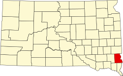
The Big Sioux River flows south-southeastward along the east line of Lincoln County. Lincoln County is on the eastern line of South Dakota. Its east boundary line abuts the west boundary line of the state of Iowa (across the river).
The county terrain consists of low rolling hills. The county area is largely devoted to agriculture. [4] The terrain slopes to the southeast, and drops off to the river valley along its east edge. [5] The county has a total area of 578 square miles (1,500 km2), of which 577 square miles (1,490 km2) is land and 0.5 square miles (1.3 km2) (0.08%) is water. [6]
Census | Pop. | Note | %± |
---|---|---|---|
1870 | 712 | — | |
1880 | 5,896 | 728.1% | |
1890 | 9,148 | 55.2% | |
1900 | 12,161 | 32.9% | |
1910 | 12,712 | 4.5% | |
1920 | 13,893 | 9.3% | |
1930 | 13,918 | 0.2% | |
1940 | 13,171 | −5.4% | |
1950 | 12,767 | −3.1% | |
1960 | 12,371 | −3.1% | |
1970 | 11,761 | −4.9% | |
1980 | 13,942 | 18.5% | |
1990 | 15,427 | 10.7% | |
2000 | 24,131 | 56.4% | |
2010 | 44,828 | 85.8% | |
2020 | 65,161 | 45.4% | |
2023 (est.) | 73,238 | [7] | 12.4% |
US Decennial Census [8] 1790-1960 [9] 1900-1990 [10] 1990-2000 [11] 2010-2020 [2] |
As of the 2020 census, there were 65,161 people, 24,877 households, and 17,239 families residing in the county. [12] The population density was 112.9 inhabitants per square mile (43.6/km2). There were 26,227 housing units.
As of the 2010 census, there were 44,828 people, 16,649 households, and 12,287 families in the county. The population density was 77.7 inhabitants per square mile (30.0/km2). There were 17,875 housing units at an average density of 31.0 per square mile (12.0/km2). The racial makeup of the county was 96.1% white, 1.0% Asian, 0.7% black or African American, 0.5% American Indian, 0.3% from other races, and 1.4% from two or more races. Those of Hispanic or Latino origin made up 1.2% of the population. In terms of ancestry, 47.1% were German, 20.9% were Norwegian, 11.7% were Irish, 7.2% were Dutch, 5.2% were English, and 3.9% were American.
Of the 16,649 households, 41.0% had children under the age of 18 living with them, 63.3% were married couples living together, 7.3% had a female householder with no husband present, 26.2% were non-families, and 20.2% of all households were made up of individuals. The average household size was 2.68 and the average family size was 3.11. The median age was 32.8 years.
The median income for a household in the county was $67,365 and the median income for a family was $75,231. Males had a median income of $43,537 versus $34,715 for females. The per capita income for the county was $33,261. About 2.7% of families and 4.3% of the population were below the poverty line, including 4.9% of those under age 18 and 7.5% of those age 65 or over.
Lincoln County voters have been reliably Republican for decades. In no national election since 1964 has the county selected a Democratic Party candidate. Only three times in its history has it voted for a different party, twice for the Democratic Party [14] [15] and once for the Progressive Party. [16] In 1924 the county voted for independent candidate LaFollete [17] who was nominated by the progressive party but ran without a label in South Dakota.
Year | Republican | Democratic | Third party(ies) | |||
---|---|---|---|---|---|---|
No. | % | No. | % | No. | % | |
2020 | 19,617 | 60.55% | 11,981 | 36.98% | 798 | 2.46% |
2016 | 15,499 | 61.43% | 8,076 | 32.01% | 1,656 | 6.56% |
2012 | 13,611 | 62.00% | 7,982 | 36.36% | 359 | 1.64% |
2008 | 11,803 | 56.84% | 8,642 | 41.61% | 322 | 1.55% |
2004 | 11,161 | 65.40% | 5,703 | 33.42% | 202 | 1.18% |
2000 | 6,546 | 62.01% | 3,844 | 36.42% | 166 | 1.57% |
1996 | 4,201 | 48.92% | 3,643 | 42.42% | 743 | 8.65% |
1992 | 3,365 | 42.47% | 2,943 | 37.15% | 1,615 | 20.38% |
1988 | 3,537 | 52.35% | 3,190 | 47.21% | 30 | 0.44% |
1984 | 3,988 | 60.10% | 2,626 | 39.57% | 22 | 0.33% |
1980 | 3,848 | 57.45% | 2,261 | 33.76% | 589 | 8.79% |
1976 | 3,105 | 51.04% | 2,957 | 48.60% | 22 | 0.36% |
1972 | 3,201 | 54.92% | 2,617 | 44.90% | 10 | 0.17% |
1968 | 3,259 | 59.89% | 1,961 | 36.03% | 222 | 4.08% |
1964 | 2,740 | 49.14% | 2,836 | 50.86% | 0 | 0.00% |
1960 | 3,553 | 64.16% | 1,985 | 35.84% | 0 | 0.00% |
1956 | 3,529 | 62.24% | 2,141 | 37.76% | 0 | 0.00% |
1952 | 4,387 | 78.35% | 1,212 | 21.65% | 0 | 0.00% |
1948 | 2,771 | 59.51% | 1,826 | 39.22% | 59 | 1.27% |
1944 | 3,298 | 66.99% | 1,625 | 33.01% | 0 | 0.00% |
1940 | 4,081 | 66.59% | 2,048 | 33.41% | 0 | 0.00% |
1936 | 2,918 | 48.42% | 2,541 | 42.17% | 567 | 9.41% |
1932 | 2,160 | 38.85% | 3,300 | 59.35% | 100 | 1.80% |
1928 | 3,463 | 71.40% | 1,364 | 28.12% | 23 | 0.47% |
1924 | 1,825 | 43.81% | 265 | 6.36% | 2,076 | 49.83% |
1920 | 2,790 | 73.54% | 441 | 11.62% | 563 | 14.84% |
1916 | 1,591 | 60.29% | 936 | 35.47% | 112 | 4.24% |
1912 | 0 | 0.00% | 719 | 28.52% | 1,802 | 71.48% |
1908 | 1,887 | 69.40% | 699 | 25.71% | 133 | 4.89% |
1904 | 2,471 | 80.49% | 378 | 12.31% | 221 | 7.20% |
1900 | 1,908 | 59.96% | 1,226 | 38.53% | 48 | 1.51% |
1896 | 1,516 | 51.86% | 1,393 | 47.66% | 14 | 0.48% |
1892 | 1,130 | 55.53% | 206 | 10.12% | 699 | 34.35% |
School districts include: [19]
Walworth County is a county in the U.S. state of South Dakota. As of the 2020 census, the population was 5,315. Its county seat is Selby. The county was created in 1873 and organized in 1883. It is named for Walworth County, Wisconsin.
Union County is the southernmost county in the U.S. state of South Dakota. As of the 2020 census, the population was 16,811, making it the 13th most populous county in South Dakota. Its county seat has been Elk Point since April 30, 1865. Originally named Cole County, its name was changed to Union on January 7, 1864, because of Civil War sentiment.
Turner County is a county in the U.S. state of South Dakota. As of the 2020 census, the population was 8,673. Its county seat is Parker. The county was established in 1871, and was named for Dakota Territory official John W. Turner.
Tripp County is a county in the U.S. state of South Dakota. As of the 2020 census, the population was 5,624. Its county seat is Winner. The county was created in 1873, and was organized in 1909. It is named for lawyer, judge, and diplomat Bartlett Tripp.
Sully County is a county in the U.S. state of South Dakota. As of the 2020 census, the population was 1,446, making it the fifth-least populous county in South Dakota. Its county seat is Onida. The county was created in 1873 and organized in 1883. It is named after General Alfred Sully, who built Fort Sully.
Roberts County is a county in the U.S. state of South Dakota. As of the 2020 census, the population was 10,280. Its county seat is Sisseton. The county was named either for S. G. Roberts of Fargo, North Dakota, or for Solomon Robar, an early local French fur trader. It was created on March 8, 1883, and fully organized by August 6 of that year. Its boundary was altered once, in 1885.
Perkins County is a county in the U.S. state of South Dakota. As of the 2020 census, the population was 2,835. Its county seat is Bison. The county was established in 1908 and organized in 1909. It was named for Sturgis, South Dakota, official Henry E. Perkins.
Moody County is a county in the U.S. state of South Dakota, United States. The population was 6,336 at the 2020 census. Its county seat is Flandreau. The county is named for Gideon C. Moody.
Minnehaha County is a county on the eastern border of the state of South Dakota. As of the 2020 census, the population was 197,214, making it the state's most populous county. It contains over 20% of the state's population. Its county seat is Sioux Falls, South Dakota's most populous city. The county was created in 1862 and organized in 1868. Its name was derived from the Sioux word Mnihaha, meaning "rapid water," or "waterfall".
McPherson County is a county in the U.S. state of South Dakota. As of the 2020 census, the population was 2,411. Its county seat is Leola.
McCook County is a county in the U.S. state of South Dakota. At the 2020 census, the population was 5,682. Its county seat is Salem. The county was established in 1873, and was organized in 1878. It was named for the former governor of the Dakota Territory and Civil War general Edwin Stanton McCook.
Lyman County is a county located in the U.S. state of South Dakota. As of the 2020 census, the population was 3,718. Its county seat is Kennebec.
Hyde County is a county in the U.S. state of South Dakota. As of the 2020 census, the population was 1,262, making it the second-least populous county in South Dakota. Its county seat is Highmore. The county was founded in 1873, as a county of the Dakota Territory, and organized in 1883. It was named for James Hyde, a member of legislature in the 1870s.
Hughes County is a county in the U.S. state of South Dakota. As of the 2020 census, the population was 17,765, making it the least populous capital county in the nation, and the 12th most populous county in South Dakota. Its county seat is Pierre, which is also the state capital. The county was created in 1873, and was organized in 1880. It was named for Alexander Hughes, a legislator. On June 4, 1891, the county's area was increased by the addition of Farm Island, in the Missouri River downstream of Pierre.
Corson County is a county in the U.S. state of South Dakota. As of the 2020 census, the population was 3,902. Its county seat is McIntosh. The county was named for Dighton Corson, a native of Maine, who came to the Black Hills in 1876, and in 1877 began practicing law at Deadwood.
Charles Mix County is a county in the U.S. state of South Dakota. As of the 2020 census, the population was 9,373. Its county seat is Lake Andes. The county was created in 1862 and organized in 1879. It was named for Charles Eli Mix, an official of the Bureau of Indian Affairs influential in signing a peace treaty with the local Lakota Indian tribes. The easternmost approximately 60% of the county comprises the Yankton Indian Reservation.
Brookings County is a county in the U.S. state of South Dakota. As of the 2020 census, the population was 34,375, making it the fifth most populous county in South Dakota. Its county seat is Brookings. The county was created in 1862 and organized in 1871.
Beadle County is a county in the U.S. state of South Dakota. As of the 2020 census, the population was 19,149, making it the 11th most populous county in South Dakota. Its county seat is Huron. The county was created in 1879 and organized in 1880. Beadle County comprises the Huron, SD Micropolitan Statistical Area.
Sioux County is a county located along the southern border of the U.S. state of North Dakota. As of the 2020 census, the population was 3,898. Its eastern border is the Missouri River and its county seat is Fort Yates.
McIntosh County is a county in the U.S. state of North Dakota. As of the 2020 census, the population was 2,530. Its county seat is Ashley. The county is notable for being the county with the highest percentage of German-Americans in the United States, with over 76% of the county's residents being of German descent as of 2010.