Yankton, South Dakota

Last updated

Yankton, South Dakota
Yankton and the Meridian Bridge.JPG
Yankton (right) along the Missouri River with the Meridian Bridge connecting Nebraska, looking west
Nickname: 
"Mother City of the Dakotas"
Yankton County South Dakota Incorporated and Unincorporated areas Yankton Highlighted.svg
Location in Yankton County and the state of South Dakota
Coordinates: 42°53′02″N97°21′54″W / 42.88389°N 97.36500°W / 42.88389; -97.36500
CountryUnited States
State South Dakota
County Yankton
Incorporated1869 [1]
Government
  Type Council-Manager
  MayorNathan Johnson [2]
   City Manager Amy Leon [3]
Area
[4]
   City 8.91 sq mi (23.08 km2)
  Land8.67 sq mi (22.45 km2)
  Water0.24 sq mi (0.62 km2)
Elevation
[5]
1,243 ft (379 m)
Population
 (2020) [6]
   City 15,411
  Density1,777.51/sq mi (686.31/km2)
   Metro
23,297 (US: 485th)
Time zone UTC−6 (CST)
  Summer (DST) UTC−5 (CDT)
ZIP codes
57078-57079
Area code 605
FIPS code 46-73060 [7]
GNIS feature ID1267665 [5]
Website cityofyankton.org

Yankton is a city in and the county seat of Yankton County, South Dakota, United States.

Contents

The population was 15,411 at the 2020 census, making it the 7th most populous city in South Dakota, [8] and it is the principal city of the Yankton Micropolitan Statistical Area, which includes the entirety of Yankton County and which had an estimated population of 23,297 as of July 1, 2021. As the first capital of Dakota Territory, it was named after the Yankton tribe of Western Dakota people; Yankton is derived from the Dakota word I-hank-ton-wan ("the end village"). [9]

Yankton is located on the Missouri River just downstream of the Gavins Point Dam and Lewis and Clark Lake, and just upstream of the confluence with the James River. The United States National Park Service's headquarters for the Missouri National Recreational River are located in the city. The Human Services Center was established as a psychiatric hospital in 1882 and is on the National Register of Historic Places.

Yankton is commonly referred to as the "River City", [10] due to its proximity to the Missouri River and the importance the river played in the city's settlement and development. Yankton has also earned the nickname "Mother City of the Dakotas", due to the early important role it played in the creation and development of the Dakota Territory, which later became the 39th and 40th U.S. states of North and South Dakota. [11]

Owing to the early exploitation of Fort Hays Limestone for cement manufacture, including shipment of cement to the construction of the Panama Canal, [12] Yankton once also had the nickname "Cement City". [13]

Geography

Yankton, as viewed from the Meridian Bridge of the Discovery Bridge crossing the Missouri River and the steeple of the Bishop Martin Marty Chapel in the background Yankton View.jpg
Yankton, as viewed from the Meridian Bridge of the Discovery Bridge crossing the Missouri River and the steeple of the Bishop Martin Marty Chapel in the background

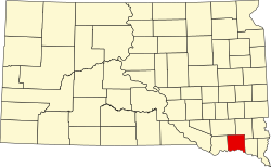
Yankton is located in southern South Dakota on the state's border with Nebraska. The city is located on one of the last free-flowing, natural stretches of the Missouri River; this segment of the river, between Gavins Point Dam four miles west of Yankton, and Ponca State Park in Nebraska, has been designated by the U.S. National Park Service as the Missouri National Recreational River.

The city is located approximately six miles west of the point where the James River flows into the Missouri.

The central business district of the city is located on a natural landing along the Missouri River, and city rises in the west to "Mount Marty" (actually a high bluff along the river). The city is also intersected by the Marne Creek, which also flows into the Missouri River. Lewis and Clark Lake is located four miles west of the city.

According to the United States Census Bureau, the city has a total area of 8.45 square miles (21.89 km2), of which 8.21 square miles (21.26 km2) is land and 0.24 square miles (0.62 km2) is water. [14]

Climate

Yankton has a humid continental climate (Köppen Dfa), with cold winters and hot summers.

Climate data for Yankton 2 E, South Dakota (1991−2020 normals, extremes 1932−present)
MonthJanFebMarAprMayJunJulAugSepOctNovDecYear
Record high °F (°C)74
(23)
78
(26)
93
(34)
95
(35)
107
(42)
110
(43)
116
(47)
112
(44)
105
(41)
96
(36)
83
(28)
70
(21)
116
(47)
Mean maximum °F (°C)54.2
(12.3)
59.6
(15.3)
74.1
(23.4)
84.8
(29.3)
90.9
(32.7)
96.8
(36.0)
98.0
(36.7)
96.6
(35.9)
92.8
(33.8)
85.8
(29.9)
71.6
(22.0)
55.4
(13.0)
100.1
(37.8)
Mean daily maximum °F (°C)30.0
(−1.1)
34.9
(1.6)
47.1
(8.4)
60.0
(15.6)
71.9
(22.2)
82.4
(28.0)
87.1
(30.6)
84.8
(29.3)
77.5
(25.3)
63.3
(17.4)
47.2
(8.4)
34.0
(1.1)
60.0
(15.6)
Daily mean °F (°C)20.2
(−6.6)
24.6
(−4.1)
35.9
(2.2)
47.7
(8.7)
59.8
(15.4)
70.7
(21.5)
75.4
(24.1)
73.1
(22.8)
64.8
(18.2)
50.9
(10.5)
36.2
(2.3)
24.5
(−4.2)
48.7
(9.3)
Mean daily minimum °F (°C)10.4
(−12.0)
14.2
(−9.9)
24.6
(−4.1)
35.4
(1.9)
47.7
(8.7)
58.9
(14.9)
63.8
(17.7)
61.5
(16.4)
52.1
(11.2)
38.5
(3.6)
25.3
(−3.7)
14.9
(−9.5)
37.3
(2.9)
Mean minimum °F (°C)−12.7
(−24.8)
−7.1
(−21.7)
2.8
(−16.2)
20.5
(−6.4)
33.7
(0.9)
47.1
(8.4)
51.8
(11.0)
50.0
(10.0)
35.7
(2.1)
21.7
(−5.7)
6.7
(−14.1)
−6.9
(−21.6)
−16.7
(−27.1)
Record low °F (°C)−29
(−34)
−28
(−33)
−25
(−32)
2
(−17)
24
(−4)
33
(1)
41
(5)
35
(2)
23
(−5)
12
(−11)
−15
(−26)
−31
(−35)
−31
(−35)
Average precipitation inches (mm)0.65
(17)
0.91
(23)
1.60
(41)
3.36
(85)
3.68
(93)
4.03
(102)
3.46
(88)
3.26
(83)
2.85
(72)
2.56
(65)
1.27
(32)
1.03
(26)
28.66
(728)
Average snowfall inches (cm)6.7
(17)
8.5
(22)
4.7
(12)
3.7
(9.4)
0.2
(0.51)
0.0
(0.0)
0.0
(0.0)
0.0
(0.0)
0.0
(0.0)
0.8
(2.0)
5.9
(15)
7.6
(19)
38.1
(97)
Average precipitation days (≥ 0.01 in)4.85.36.38.811.610.68.08.57.36.94.85.288.1
Average snowy days (≥ 0.1 in)3.33.62.41.20.10.00.00.00.00.51.63.816.5
Source: NOAA [15] [16]

Demographics

Historical population
CensusPop.Note
1880 3,431
1890 3,6707.0%
1900 4,12512.4%
1910 3,787−8.2%
1920 5,02432.7%
1930 6,07220.9%
1940 6,79812.0%
1950 7,70913.4%
1960 9,27920.4%
1970 11,91928.5%
1980 12,0110.8%
1990 12,7035.8%
2000 13,5286.5%
2010 14,4546.8%
2020 15,4116.6%
2021 (est.)15,483 [17] 0.5%
U.S. Decennial Census [18]
2020 Census [8] [6]

2010 census

As of the census of 2010, there were 14,454 people, 5,909 households, and 3,348 families residing in the city. The population density was 1,760.5 inhabitants per square mile (679.7/km2). There were 6,365 housing units at an average density of 775.3 per square mile (299.3/km2). The racial makeup of the city was 92.1% White, 2.1% African American, 2.3% Native American, 0.7% Asian, 1.3% from other races, and 1.6% from two or more races. Hispanic or Latino of any race were 3.4% of the population.

There were 5,909 households, of which 27.3% had children under the age of 18 living with them, 43.1% were married couples living together, 10.1% had a female householder with no husband present, 3.5% had a male householder with no wife present, and 43.3% were non-families. 37.5% of all households were made up of individuals, and 15.2% had someone living alone who was 65 years of age or older. The average household size was 2.17 and the average family size was 2.87.

The median age in the city was 40.4 years. 20.9% of residents were under the age of 18; 9% were between the ages of 18 and 24; 26% were from 25 to 44; 26.1% were from 45 to 64; and 17.9% were 65 years of age or older. The gender makeup of the city was 50.5% male and 49.5% female.

2000 census

As of the census of 2000, there were 13,528 people, 5,369 households, and 3,232 families residing in the city. The population density was 1,743.2 inhabitants per square mile (673.1/km2). There were 5,735 housing units at an average density of 739.0 per square mile (285.3/km2). The racial makeup of the city was 94.35% White, 1.64% African American, 1.58% Native American, 0.50% Asian, 0.03% Pacific Islander, 0.90% from other races, and 0.99% from two or more races. Hispanic or Latino of any race were 2.46% of the population.

There were 5,369 households, out of which 29.5% had children under the age of 18 living with them, 47.5% were married couples living together, 9.8% had a female householder with no husband present, and 39.8% were non-families. 34.9% of all households were made up of individuals, and 15.0% had someone living alone who was 65 years of age or older. The average household size was 2.27 and the average family size was 2.96.

In the city, the population was spread out, with 23.4% under the age of 18, 9.8% from 18 to 24, 28.2% from 25 to 44, 21.4% from 45 to 64, and 17.2% who were 65 years of age or older. The median age was 38 years. For every 100 females, there were 96.1 males. For every 100 females age 18 and over, there were 95.0 males.

As of 2000 the median income for a household in the city was $31,843, and the median income for a family was $44,009. Men had a median income of $29,012 versus $20,577 for women. The per capita income for the city was $17,954. About 6.2% of families and 10.2% of the population were below the poverty line, including 10.8% of those under age 18 and 9.1% of those age 65 or over.

According to the 2003 Coldwell Banker Housing Price Comparison Index (HPCI), Yankton was found to have the lowest housing costs of any municipal entity in the entire United States. This is no longer the case as of the 2005 HPCI.

History

Native inhabitants

The Dakota Territory in 1861. DakotaTerritory.png
The Dakota Territory in 1861.

The site of Yankton was occupied by the Yankton Sioux (Dakota) prior to the arrival of European settlers. As part of the vast Louisiana Purchase, the site of Yankton was visited by Lewis and Clark in 1804. In the journals of the expedition, the explorers write of a meeting on August 30, 1804, with members of the Yankton Sioux Tribe on a Missouri River bluff presently known as Calumet Bluff. As recently as 1857, the present day site of Yankton was occupied by a village of Yankton Sioux led by Chief Pa-le-ne-a-pa-pe ("Struck by the Ree"). [19] Two years later, with the signing of the Yankton Treaty of 1858, the land was opened for settlement. [20] The city was founded where the small Rhine Creek (renamed Marne Creek in World War I) flowed into the Missouri River. [21] The city grew as a stop for steamboats to take on fresh water and supplies, especially after steamboat traffic boomed when gold was discovered in the Black Hills.

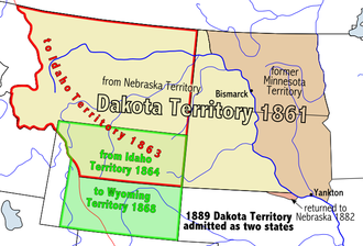
Dakota territorial capital

A modern replica of the Dakota Territorial Capitol building stands in Yankton's Riverside Park. Dakota Territory Capitol Replica Yankton.JPG
A modern replica of the Dakota Territorial Capitol building stands in Yankton's Riverside Park.

With two days left in his term, President James Buchanan signed a law on March 2, 1861, creating the Dakota Territory. Yankton was designated as the territorial capital, and newly inaugurated President Abraham Lincoln appointed his personal physician, William A. Jayne of Springfield, Illinois, as the first territorial governor. [22] The territorial capitol building, a plain, two-story wooden structure, was located at the intersection of Fourth and Capitol Streets; [23] the original structure has been demolished, but a replica of the building has been constructed in Yankton's Riverside Park. Yankton served as the territorial capital until 1883 when the capital was moved to Bismarck (now the capital of North Dakota). [24]

Yankton Stockade

In response to the Dakota War of 1862 in western Minnesota, Governor Jayne issued a proclamation on August 30, 1862, requiring every male between the ages of 18 and 50 in every settlement in eastern Dakota, be formed into militias to protect against expected attacks from the Native Americans. [25] In response, the Yankton militia built a stockade at the corner of Third Street and Broadway Avenue of approximately 200,000 square feet. Settlers from the surrounding area, and as far away as Sioux Falls and Bon Homme County, fled to Yankton to seek shelter in the structure.

Although roving bands of Native Americans did approach Yankton over the course of several weeks, no attack ensued, and the stockade was eventually abandoned and torn down. There is a historical marker at the site of the former stockade. [26]

Among the most notable events that occurred in Yankton while capital, Jack McCall, murderer of Wild Bill Hickok in Deadwood on August 2, 1876, was tried in Yankton for Hickok's murder, found guilty, and was hanged on March 1, 1877, at the age of 24. His body is buried in a Yankton cemetery. [27]

Yankton College

The conservatory building on the former Yankton College campus - now a part of the Yankton Federal Prison Camp. Yankton College Conservatory.jpg
The conservatory building on the former Yankton College campus – now a part of the Yankton Federal Prison Camp.

Due to the urging of the Reverend Joseph Ward of Yankton, the General Association of Congregational Churches in Dakota Territory voted in May 1881 to establish "Pilgrim College" in Yankton, which was to be the first private institution of higher learning in Dakota. [28] When the college was incorporated in August 1881, the name had been changed to "Yankton College". Classes commenced in October 1882, and Yankton College played a prominent role in the city for over 100 years.

Then, in 1983, the small liberal arts college was forced to close due to financial insolvency. After remaining vacant for several years, the historic campus, which is listed on the National Register of Historic Places, was purchased by the United States Federal Bureau of Prisons for use as a minimum security prison. The Federal Prison Camp – Yankton houses approx 850 male inmates. [29]

River Port and the Flood of 1881

A view of Yankton's riverfront after the flood of March 1881. Blasting ice with dynamite from in front of steamer on the ways, by Stanley J. Morrow.png
A view of Yankton's riverfront after the flood of March 1881.

Since its founding, Yankton enjoyed a natural advantage as a steamboat landing along the Missouri River due to the fact that its landing stretched along the entire length of the town's riverfront. [30] The first steamboat to reach Yankton from St. Louis arrived in 1859, providing goods and supplies to settlers and fur-traders in upper and central Dakota. [31] Since then, the city continued to grow and quickly became the second largest city in South Dakota. The railroad reached Yankton in 1872. In 1874, gold was discovered in the Black Hills and prospectors rushed into Dakota Territory. [32] By 1880, Yankton had become an established riverboat port on the Missouri River. It retained its position as the second largest city in South Dakota until the beginning of the 20th century. [33]

The city's status as an important port was literally crushed on March 27, 1881, when an ice dam on the Missouri River burst, sending flood waters and giant blocks of ice flowing towards the town. [34]

The resulting flood waters continued to accumulate behind the debris, and by March 29, the town's riverfront and downtown were covered in water, ice and rock, destroying or stranding several riverboats that were moored there. As a result of this flood, and the expansion of railroads as a preferred method of shipping goods, Yankton's river boat traffic was reduced, and the city's role as a prominent stopping point on the way west dwindled over the next several years. [35]

Francis Marion Ziebach established the second newspaper in the area that became South Dakota, the Weekly Dakotan, in Yankton on June 6, 1861, bringing his outfit from Sioux Falls by team and wagon. [36] A second newspaper, started by Francis Marion Ziebach, is still published today as the Yankton Press and Dakotan. [37]

In 1882, the Human Services Center was established as a psychiatric hospital. On June 2, 1883, Dakota Territory Governor Nehemiah G. Ordway moved the territorial capital from Yankton to Bismarck, present-day North Dakota.

National Register of Historic Places

A Sample of Historic Structures in Yankton, South Dakota
Governor John L. Pennington House from SE.JPG
Gov. Pennington House
Ohlman-Shannon House from NE 1.JPG
Ohlman-Shannon House
Bruce-Donaldson House from SE.JPG
Bruce-Donaldson House
Bishop Marty Rectory from SE.JPG
Bishop Marty House

As evidence of its rich historical past, Yankton has 26 individual properties and 6 historic districts within the city listed on the National Register of Historic Places, maintained by the U.S. National Park Service.[ citation needed ] Each individual district contains several structures, and include:

Government

Yankton is governed by the City Commission, under a Council-Manager form of Local Government. The City Commission is responsible for legislative functions such as establishing policy, passing local ordinances, and voting appropriations. The City Commission appoints the City Manager to oversee the administrative operations, implement its policies, and advise the commission. The manager position is similar to that of corporate chief executive officer (CEO), providing professional management to the board of directors. [38] There are nine Commissioners that are elected by the citizens, and the Mayor is elected by the commission. As of 2018 the current Mayor is Nathan Johnson.

Yankton Police Department
Yankton, SD Police.jpg
Patch of the Yankton Police Department
AbbreviationYPD
Jurisdictional structure
Governing body Yankton City Commission
General nature
Operational structure
HeadquartersYankton Public Safety Center
410 Walnut St., Yankton, South Dakota 57078
Police Officers 29 [39]
Agency executive
Website
Yankton Police Department

The Yankton Police Department provides law enforcement for the city's residents. [39] In 2006 it employed 29 sworn personnel. [40]

Education

Yankton is served by the Yankton Public School District (K-12), Sacred Heart Catholic School (pK-8), and Mount Marty College.

Yankton was once home to Yankton College; founded in 1881, it was the first liberal arts college in the Dakota Territory. The college closed in 1984. The campus was acquired by the Federal Bureau of Prisons in 1988 for use as the Federal Prison Camp – Yankton.

The Yankton School District has a variety of extracurricular activities including athletics and non-athletics. The athletic teams are universal on all levels of education including the Yankton Middle School and the Yankton High School. The boys' athletic teams are known as the Yankton Bucks and the girls' teams are known as the Yankton Gazelles. Yankton's debate team is the host of the annual Lewis and Clark Debate Tournament, held on the last weekend of the month of January.

Yankton is home to Mount Marty University, a private Benedictine Catholic institution of higher learning. [41] Mounty Marty College Academy was founded in 1922 and subsequently changed their name to Mount Marty College in 1951 when they became a four-year, baccalaureate degree granting institution. The most recent change was the addition of doctoral programs and a transition to Mount Marty University in 2020. [41] Mount Marty University athletes are known as the Lancers [42] and compete in the National Association of Intercollegiate Athletics. [43]

Recreation

Gavins Point Dam, constructed from 1952 to 1957 (foreground) with Lewis and Clark Lake in the background, just west of Yankton. Gavins Point Dam.jpg
Gavins Point Dam, constructed from 1952 to 1957 (foreground) with Lewis and Clark Lake in the background, just west of Yankton.

The City of Yankton maintains fourteen municipal parks, including Fantle Memorial Park, which is the location of an outdoor public swimming pool, and Riverside Park, which is home to the city's Riverside Baseball Field. There are two golf courses in the city: the Fox Run municipal golf course, and the private golf course located at Hillcrest Golf and Country Club. [44] The City of Yankton and the Yankton School District jointly maintain and operate the Yankton High School and Summit Activities Center; this facility offers an indoor swimming pool, several gymnasiums, and a public weight lifting room. [45]

The double-decker Meridian Bridge over the Missouri River was decommissioned for traffic in October 2008 after the new Discovery Highway Bridge was opened. This old bridge was converted to a pedestrian bridge (photo), and is part of the city's extensive pedestrian and bicycle path system. [46] The Brokaw-Auld Trail is a linear park and recreational path along Marne Creek, and the State of South Dakota has developed trails and paths to and throughout the Lewis and Clark Recreation Area.

Four miles west of Yankton, Lewis and Clark Lake attracts over 1.5 million visitors per year. The Lewis and Clark State Recreation Area, extending approximately two miles along the north shore of Lewis and Clark Lake, offering camping, swimming, hiking/biking trails, and boating facilities. The Lewis and Clark Resort and Marina is located within the park and offers cabin rentals, marina slips, convenience store, and a waterfront restaurant. The U.S. Army Corps of Engineers also maintains public recreation areas along the Missouri River just downstream of Gavins Point Dam. [47] [48]

Transportation

The Discovery Bridge at night. DiscoveryBridgeYanktonNight.JPG
The Discovery Bridge at night.

Air transportation is provided by the Chan Gurney Municipal Airport, owned by the City of Yankton; however, the nearest airports with commercial flights are Sioux Falls Regional Airport in Sioux Falls and Sioux Gateway Airport in Sioux City, Iowa. [49]

U.S. Route 81 serves the city as a north–south highway that connects the city with Nebraska across the Missouri River to the south via the Discovery Bridge, which replaced the Historic Meridian Highway Bridge in 2008. [50] Interstate 90 is approximately 65 miles north of the city, and Interstate 80 is about 160 miles south of the city, via U.S. Route 81. U.S. Route 81 is also signed as Broadway Avenue within city limits.

South Dakota Highway 50 serves the city as an east–west highway and includes a four-lane divided highway that connects the city to Interstate 29, approximately 33 miles to the east.

South Dakota Highway 52 connects the city to the Lewis and Clark Lake area, about four miles to the west.

Media

Broadcasting in Yankton began in 1922 when WNAX radio went on the air. Today, two AM radio stations and two commercial FM stations are licensed to Yankton: [51]

Radio

AM radio

AM radio stations
FrequencyCall signNameFormatOwnerCity
570 AM WNAX WNAX Radio 570 News/Talk Saga CommunicationsYankton
1450 AM KYNT Yankton's Home Team Soft Adult Contemporary Riverfront Broadcasting LLCYankton
1570 AM KVTK 1570 "The Ticket Sports talk Culhane Communications, Inc.Vermillion

FM radio

FM radio stations
FrequencyCall signNameFormatOwnerTarget city/market City of license
89.7 FM KUSD South Dakota Public BroadcastingNPRSD board of directors for Educational TelecommunicationsYankton/VermillionVermillion
93.1 FM KKYA Hot Country 93.1 Country music Riverfront Broadcasting LLCYankton/VermillionYankton
94.3 FM KDAM The Current Hot AC Riverfront Broadcasting LLCYankton/VermillionHartington
104.1 FM WNAX-FM The Wolf 104.1 Country music Saga CommunicationsYankton/VermillionYankton
106.3 FM KVHT Classic Hits 106.3 Classic Hits Cullhane Communications, Inc.Yankton/VermillionVermillion

Several low-power non-commercial FM stations are licensed to Yankton.[ citation needed ]

There are no commercial television stations based in Yankton. Stations from Sioux Falls and Sioux City serve Yankton. [52] One Sioux Falls station, KTTW (digital channel 7), is rebroadcast on analog channel 21 in Yankton. [53]

KUSD-TV, the flagship station of South Dakota Public Broadcasting, is based in nearby Vermillion.[ citation needed ]

Yankton is also home to South Dakota Magazine, a statewide bi-monthly publication that explores the history, culture, arts, travel and outdoors of the state. It is published in a historic building constructed in 1875 by Territorial Governor John Pennington.[ citation needed ]

Culture

The abandoned Mead Building on the South Dakota Human Services Center campus in Yankton has been identified as the future site of the Dakota Territorial Museum. Yankton Human Services Center 1.JPG
The abandoned Mead Building on the South Dakota Human Services Center campus in Yankton has been identified as the future site of the Dakota Territorial Museum.

Mount Marty University offers several cultural assets and venues in Yankton, including the Bede Art Gallery, which showcases artwork from regional and Native American artists, as well as Marian Auditorium, which hosts performing and fine art events. The college is also home to Great Plains Writers' Tour, which brings award-winning professional writers to campus for readings and class workshops. Previous authors include former United States poet laureate Ted Kooser, American Book Award winner Maria Mazziotti Gillan, Elizabeth Cook-Lynn, David Lee, and William Kloefkorn, among others. [54]

Yankton is also home to the Dakota Territorial Museum, which is housed in the newly restored Mead Cultural Education Building on the campus of the Human Services Center in north Yankton. The collection contains information and artifacts about the heritage and development of the City of Yankton and the surrounding area. The museum's collection includes artifacts of Dakota Territory, Native American inhabitants, and early pioneers. The museum complex also contains several outbuildings, such as a restored rural school house and the Great Northern Railway Depot which will be moved to the new location at 82 Mickelson Drive in the latter part of 2019. The museum also displays a retired Burlington Northern Railway caboose. [55]

Yankton's Riverboat Days is an annual celebration held in the third full weekend in August. The primarily free event attracts 135,000 people and hosts over 150 artists and over 50 food vendors at Riverside Park. Other activities include a rodeo, parade, golf tournament, and snowmobile grass drag race. [56]

Sports

The National Field Archery Association, NFAA, moved its headquarters from Redland, California to Yankton, South Dakota. [57]

Special sporting events

The National Field Archery Association's Easton Yankton Archery Complex hosted nearly 600 archers from 51 countries for the 2015 World Archery Youth Championships. [58]

Contemporary culture

Games

Television

Notable people

Statue of steamboat captain Grant Marsh in Riverside Park, Yankton, South Dakota. Capt. Grant Marsh Statue, Riverside Park, Douglas Ave. & Levee St.,Yankton, South Dakota.jpg
Statue of steamboat captain Grant Marsh in Riverside Park, Yankton, South Dakota.
Home and barn of Grant Marsh, 513 Douglas St., Yankton, South Dakota. Marsh was the most famous steamboat captain on the Missouri River. Capt. Grant Marsh home, 513 Douglas St. (near 6th St.), Yankton, South Dakota.jpg
Home and barn of Grant Marsh, 513 Douglas St., Yankton, South Dakota. Marsh was the most famous steamboat captain on the Missouri River.

See also

Related Research Articles

<span class="mw-page-title-main">South Dakota</span> U.S. state

South Dakota is a U.S. state in the North Central region of the United States. It is also part of the Great Plains. South Dakota is named after the Dakota Sioux tribe, which comprises a large portion of the population with nine reservations currently in the state and has historically dominated the territory. South Dakota is the 17th largest by area, but the 5th least populous, and the 5th least densely populated of the 50 United States. Pierre is the state capital, and Sioux Falls, with a population of about 213,900, is South Dakota's most populous city. The state is bisected by the Missouri River, dividing South Dakota into two geographically and socially distinct halves, known to residents as "East River" and "West River". South Dakota is bordered by the states of North Dakota, Minnesota, Iowa, Nebraska, Wyoming, and Montana.

<span class="mw-page-title-main">Yankton County, South Dakota</span> County in South Dakota, United States

Yankton County is a county in the U.S. state of South Dakota. As of the 2020 census, the population was 23,310. Its county seat is Yankton. Yankton County comprises the Yankton, SD Micropolitan Statistical Area.

<span class="mw-page-title-main">Charles Mix County, South Dakota</span> County in South Dakota, United States

Charles Mix County is a county in the U.S. state of South Dakota. As of the 2020 United States Census, the population was 9,373. Its county seat is Lake Andes. The county was created in 1862 and organized in 1879. It was named for Charles Eli Mix, an official of the Bureau of Indian Affairs influential in signing a peace treaty with the local Lakota Indian tribes. The easternmost approximately 60% of the county comprises the Yankton Indian Reservation.

<span class="mw-page-title-main">Bon Homme County, South Dakota</span> County in South Dakota, United States

Bon Homme County is a county in the U.S. state of South Dakota. As of the 2020 census, the population was 7,003. Its county seat is Tyndall.

<span class="mw-page-title-main">Springfield, South Dakota</span> City in South Dakota, United States

Springfield is a city in Bon Homme County, South Dakota, United States. The population was 1,914 at the 2020 census. As of 2023, about 1,250 of the residents were inmates at Mike Durfee State Prison.

<span class="mw-page-title-main">Vermillion, South Dakota</span> City in South Dakota, United States

Vermillion is a city and the county seat of Clay County. It is in the southeastern corner of South Dakota, United States, and is the state's 12th-most populous city. According to the 2020 Census, the population was 11,695. The city lies atop a bluff near the Missouri River.

<span class="mw-page-title-main">Sioux City, Iowa</span> City in Iowa, United States

Sioux City is a city in Woodbury and Plymouth counties in the northwestern part of the U.S. state of Iowa. The population was 85,797 in the 2020 census, making it the fourth-most populous city in Iowa. The bulk of the city is in Woodbury County, of which it is the county seat, though a small northern portion is in Plymouth County. Sioux City is located at the navigational head of the Missouri River. The city is home to several cultural points of interest including the Sioux City Public Museum, Sioux City Art Center and Sergeant Floyd Monument, which is a National Historic Landmark. The city is also home to Chris Larsen Park, commonly referred to as "the Riverfront", which includes the Anderson Dance Pavilion, Sergeant Floyd Riverboat Museum and Lewis and Clark Interpretive Center. Sioux City is the primary city of the five-county Sioux City, IA–NE–SD Metropolitan Statistical Area (MSA), with a population of 149,940 in the 2020 census. The Sioux City–Vermillion, IA–NE–SD Combined Statistical Area had a population of 175,638 as of 2020.

Mount Marty University is a private Benedictine university in Yankton, South Dakota.

<span class="mw-page-title-main">Lewis and Clark Lake</span> Man-made lake in Nebraska and South Dakota, United States

Lewis and Clark Lake is a 31,400 acre (130 km²) reservoir located on the border of the U.S. states of Nebraska and South Dakota on the Missouri River. The lake is approximately 25 miles (40 km) in length with over 90 miles (140 km) of shoreline and a maximum water depth of 45 feet (14 m). The lake is impounded by Gavins Point Dam and is managed by the U.S. Army Corps of Engineers, Omaha District.

The Missouri National Recreational River is a National Recreational River located on the border between Nebraska and South Dakota. The designation was first applied in 1978 to a 59-mile section of the Missouri River between Gavins Point Dam and Ponca State Park. In 1991, an additional 39-mile section between Fort Randall Dam and Niobrara, Nebraska, was added to the designation. These two stretches of the Missouri River are the only parts of the river between Montana and the mouth of the Missouri that remain undammed or unchannelized. The last 20 miles of the Niobrara River and 6 miles of Verdigre Creek were also added in 1991.

<span class="mw-page-title-main">WNAX (AM)</span> News/talk radio station in Yankton, South Dakota

WNAX is a radio station in Yankton, South Dakota, currently owned by Saga Communications, Inc., which broadcasts a news/talk format.

<span class="mw-page-title-main">WNAX-FM</span> Country music radio station in Yankton, South Dakota

WNAX-FM is a radio station broadcasting a country format. Licensed to Yankton, South Dakota, it serves the Yankton, Vermillion, and Sioux City areas. The station is currently owned by Saga Communications, Inc.

<span class="mw-page-title-main">Roman Catholic Diocese of Sioux Falls</span> Diocese of the Catholic Church

The Diocese of Sioux Falls is a Latin Church diocese of the Catholic Church diocese in South Dakota in the United States. It is a suffragan see of the metropolitan Archdiocese of Saint Paul and Minneapolis.

<span class="mw-page-title-main">Yankton Indian Reservation</span> Indian reservation in United States, Yankton Sioux

The Yankton Indian Reservation is the homeland of the Yankton Sioux Tribe of the Dakota tribe.

<span class="mw-page-title-main">History of South Dakota</span>

The history of South Dakota describes the history of the U.S. state of South Dakota over the course of several millennia, from its first inhabitants to the recent issues facing the state.

<span class="mw-page-title-main">Geography of South Dakota</span> Overview of the geography of South Dakota

South Dakota is a state located in the north-central United States. It is usually considered to be in the Midwestern region of the country. The state can generally be divided into three geographic regions: eastern South Dakota, western South Dakota, and the Black Hills. Eastern South Dakota is lower in elevation and higher in precipitation than the western part of the state, and the Black Hills are a low, isolated mountain group in the southwestern corner of the state. Smaller sub-regions in the state include the Coteau des Prairies, Missouri Coteau, James River Valley, and the Dissected Till Plains. Geologic formations in South Dakota range in age from two billion-year-old Precambrian granite in the Black Hills to glacial till deposited over the last few million years. South Dakota is the 17th-largest state in the country.

<span class="mw-page-title-main">Yankton Sioux Tribe</span> Federally recognized tribe in South Dakota, U.S.

The Yankton Sioux Tribe of South Dakota is a federally recognized tribe of Yankton Western Dakota people, located in South Dakota. Their Dakota name is Ihaƞktoƞwaƞ Dakota Oyate, meaning "People of the End Village" which comes from the period when the tribe lived at the end of Spirit Lake just north of Mille Lacs Lake.

<span class="mw-page-title-main">Outline of South Dakota</span> Overview of and topical guide to South Dakota

The following outline is provided as an overview of and topical guide to South Dakota:

<span class="mw-page-title-main">Calumet Bluff</span> Dam in Nebraska, U.S.

Calumet Bluff is a hill about 180 feet high overlooking Lewis and Clark Lake and the Missouri River in Cedar County, Nebraska, U.S., where the Lewis and Clark Expedition held its first council with the Sioux Indians for two days in 1804. Today the Bluff forms the right or south abutment of the Gavins Point Dam. The U.S. Army Corps of Engineers maintains the Lewis and Clark Visitor Center and the Gavins Point Project Administration Offices on Calumet Bluff overlooking the dam.

This timeline of South Dakota is a list of events in the history of South Dakota by year.

References

  1. "SD Towns" (PDF). South Dakota State Historical Society. Archived (PDF) from the original on February 10, 2010. Retrieved February 17, 2010.
  2. "Boards and Committees". City of Yankton. Archived from the original on December 24, 2017. Retrieved December 25, 2017.
  3. "City Manager". Archived from the original on February 13, 2010. Retrieved March 12, 2010.
  4. "ArcGIS REST Services Directory". United States Census Bureau. Retrieved October 15, 2022.
  5. 1 2 U.S. Geological Survey Geographic Names Information System: Yankton, South Dakota
  6. 1 2 "Census Population API". United States Census Bureau. Retrieved October 15, 2022.
  7. "U.S. Census website". United States Census Bureau . Retrieved January 31, 2008.
  8. 1 2 "Explore Census Data". Explore Census Data. United States Census Bureau . Retrieved July 21, 2022.
  9. Riggs, S.R., The Reverend (1852) – Smithsonian Contributions to Knowledge: Grammar and Dictionary of the Dakota Language. Smithsonian Institution/G.P. Putnam, New York, N.Y. pp. 297, 336.
  10. "City of Yankton, South Dakota". South Dakota Magazine. Archived from the original on July 22, 2014. Retrieved April 20, 2013.
  11. "SC 18 Honoring the city of Yankton on the one hundred fiftieth anniver..." sd.us. Archived from the original on March 7, 2011. Retrieved February 3, 2016.
  12. Kathy K. Grow; Lois H. Varvel (2004). Yankton, South Dakota in Vintage Postcards. p. 24. ISBN   9780738532332 . Retrieved August 3, 2018.
  13. Paula Kapitan (January 26, 1979). "National Register of Historic Places Inventory/Nomination: Gurney, Charles, Hotel". National Park Service . Retrieved August 5, 2019. With accompanying pictures
  14. "US Gazetteer files 2010". United States Census Bureau. Archived from the original on February 20, 2011. Retrieved June 21, 2012.
  15. "NowData − NOAA Online Weather Data". National Oceanic and Atmospheric Administration. Retrieved October 18, 2021.
  16. "Station: Yankton 2 E, SD". U.S. Climate Normals 2020: U.S. Monthly Climate Normals (1991−2020). National Oceanic and Atmospheric Administration. Retrieved October 18, 2021.
  17. "City and Town Population Totals: 2020-2021". United States Census Bureau. September 20, 2022. Retrieved September 20, 2022.
  18. United States Census Bureau. "Census of Population and Housing" . Retrieved September 23, 2013.
  19. Kingsbury, George W. (1915). History of Dakota Territory. Chicago, IL: S.J. Clarke Publishing Company. p. 115.
  20. "History of Yankton, South Dakota". Yankton, South Dakota. Archived from the original on February 14, 2008.
  21. "History of Yankton". Press & Dakotan. Archived from the original on March 2, 2008. Retrieved February 3, 2008.
  22. Milton, John R. (1988) – South Dakota: A History – W.W. Norton and Company, New York, N.Y. – pp. 71
  23. Karolevitz, Robert F. (1972). Yankton: A Pioneer Past. Aberdeen, SD: North Plains Press. pp. 40–41.. U.S. Library of Congress Number 72-88949
  24. Fabry, Merrill (July 14, 2016). "Now You Know: Why Are There Two Dakotas?". Time. Archived from the original on January 24, 2019. Retrieved February 5, 2019.
  25. Kingsbury (1915), pp. 235–244.
  26. "West Wall / Yankton Stockade Historical Marker". www.hmdb.org. Retrieved April 25, 2022.
  27. Karolevitz (1972), p. 85.
  28. Karolevitz (1972), pp. 99–100.
  29. "fpc yankton". federal criminal defense attorney.
  30. Kingsbury (1915), p. 567.
  31. Kingsbury (1915), p. 568.
  32. Kingsbury (1915), pp. 891–896.
  33. Contents – South Dakota (PDF). Fourteenth Census (Report). 1920. p. 8.
  34. Karolevitz (1972), pp. 92–95.
  35. Karolevitz (1972), p. 95.
  36. Lee, James Melvin (1917). – History of American Journalism. – Houghton Mifflin Company. – pp.246–247.
    — Coursey, Oscar William (1917). – Who's Who in South Dakota. – Educator Supply Company.
    — NOTE: According to these sources, the first newspaper in what is now South Dakota was the Dakota Democrat published in Sioux Falls for about four years starting in 1858, and the Weekly Dakotan was the second newspaper in what is now South Dakota, starting on June 4, 1861.
  37. A South Dakota Guide. – Federal Writer’s Project. – 1938. – p.35.
  38. "City Commission – City of Yankton, SD". www.cityofyankton.org. Archived from the original on December 24, 2018. Retrieved December 23, 2018.
  39. 1 2 "Police Department – City of Yankton, SD". www.cityofyankton.org. Archived from the original on December 10, 2018. Retrieved December 23, 2018.
  40. "Yankton Police Department". Archived from the original on October 6, 2006. Retrieved October 2, 2008.
  41. 1 2 "History | Mount Marty University". www.mountmarty.edu. Retrieved June 1, 2022.
  42. "Mount Marty University Athletics". Mount Marty University Athletics. Retrieved June 1, 2022.
  43. "NAIA" (PDF). NAIA. Retrieved June 1, 2022.
  44. "City of Yankton, Department of Parks and Recreation". Archived from the original on August 5, 2012. Retrieved July 19, 2013.
  45. "City of Yankton, Summit Activities Center". Archived from the original on September 18, 2013. Retrieved July 19, 2013.
  46. "City of Yankton, Trails System". Archived from the original on July 22, 2014. Retrieved July 19, 2013.
  47. "SD GFP – State Parks – Directory – Lewis and Clark". Lewis & Clark Recreation Area. Archived from the original on February 2, 2016. Retrieved February 3, 2016.
  48. "Omaha District > Missions > Dam and Lake Projects > Missouri River Dams > Gavins Point". Archived from the original on April 22, 2018. Retrieved April 14, 2018.
  49. "City of Yankton Airport". City of Yankton. Archived from the original on May 8, 2018. Retrieved May 7, 2018.
  50. "Meridian Bridge – City of Yankton, SD". www.cityofyankton.org. Archived from the original on April 28, 2018. Retrieved May 8, 2018.
  51. "Radio Stations in Yankton, South Dakota". Radio-Locator. Theodric Technologies LLC. Retrieved May 6, 2010.
  52. "TV Signal Analysis Results". TVFool. Archived from the original on July 17, 2011. Retrieved May 6, 2010.
  53. "South Dakota TV Stations". NorthPine.com. Archived from the original on May 14, 2009. Retrieved May 6, 2010.
  54. "Great Plains Writers' Tour". mtmc.edu. Mount Marty College. Archived from the original on January 27, 2015. Retrieved October 22, 2014.
  55. Dakota Territorial Museum website
  56. "About South Dakota Magazine". South Dakota Magazine. Archived from the original on May 2, 2019. Retrieved July 19, 2019.
  57. "Archery HQ Gets a Huge Boost". Archived from the original on June 17, 2015. Retrieved June 17, 2015.
  58. "World Tourney Boosts Future Of Yankton Archery Complex". Keloland.com. Archived from the original on June 17, 2015. Retrieved June 17, 2015.
  59. "William Henry Harrison Beadle". Architect of the Capitol – United States Capitol. Archived from the original on January 28, 2016. Retrieved February 3, 2016.
  60. 'Wisconsin Blue Book 1897,' Biographical Sketch of Abner S. Flagg, pg. 693–694
  61. Karolevitz (1972), pp. 2–4.