Clark, South Dakota

Last updated

Clark, South Dakota
CLARK COUNTY COURTHOUSE, CLARK,SD.JPG
Clark County Courthouse in Clark
Clark County South Dakota Incorporated and Unincorporated areas Clark Highlighted.svg
Location within Clark County and South Dakota
Coordinates: 44°52′36″N97°44′05″W / 44.87667°N 97.73472°W / 44.87667; -97.73472
CountryUnited States
State South Dakota
County Clark
Incorporated1886 [1]
Area
[2]
  Total1.35 sq mi (3.51 km2)
  Land1.35 sq mi (3.51 km2)
  Water0.00 sq mi (0.00 km2)
Elevation
[3]
1,811 ft (552 m)
Population
 (2020) [4]
  Total1,148
  Density848.48/sq mi (327.51/km2)
Time zone UTC−6 (Central (CST))
  Summer (DST) UTC−5 (CDT)
ZIP code
57225
Area code 605
FIPS code 46-12180
GNIS feature ID1267330 [3]
Website www.clarksd.com

Clark is a city in and county seat of Clark County, South Dakota, United States. The population was 1,148 at the 2020 census. [5]

Contents

History

1883 illustration of Clark Clark SD 1883.jpg
1883 illustration of Clark

A post office was established at Clark in 1880. [6] Clark was platted in 1882. [7] The city took its name from Clark County. [7] An early variant name was Clark Center. [8]

City of Clark Water Tower Clark Water Tower.jpg
City of Clark Water Tower

In 1882, railroad tracks were first built through the middle of Clark. The Burlington Northern railroad and County Highway 212 ran parallel to one another and divided Clark into halves - the north half and the south half. Highway 212 similarly runs through the middle of Clark, and provides a direct travel route starting in Minneapolis, Minnesota, into Clark, then went to the Black Hills and to Yellowstone National Park.

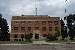
Clark was officially founded in 1886, three years before South Dakota became a state. Not long after in June 1899, the local government took action, and the Clark City Council passed Ordinance No. 26. Serving as one of the first regulations enacted in Clark, Ordinance No. 26 made it unlawful for a person to ride a horse or bicycle, faster than eight miles an hour down Commercial Street. Eighteen years later, in 1917, residents from Elrod, a small town east of Clark, made a failed effort to move the county seat from Clark to Elrod. As of 2019, Clark still serves as the county seat and houses the modest Clark County Courthouse and a public library.

As for Clark's population, the highest number of residents was during the 1950s and early 1960s, which peaked at nearly 1,500 residents. In 1970, the numbers decreased to approximately 1,356 residents, and has decreased each decade thereafter. In 2016, the estimated population of Clark was 1,050 residents, or nearly a 30% population drop from the 1960s.

In the 1960s, when the town reached its peak population, residents from surrounding municipalities commonly traveled to Clark for work, entertainment, and to attend school with the Clark Public School System. Neighboring Townships, including Thorpe, Carpenter, and Garfield, bused their students to attend school at one of the three school buildings which offered a K through 12 education.

Many residents who called Clark home lived on family farms on the outskirts of town. And those living in town mostly resided in relatively modest homes, and often worked in the retail stores on Commercial Street.

Through the 1960s, the Clark community was able to support a variety of small businesses, including two hardware stores, two banks, two grain elevators, two clothing stores, a jewelry store, a movie theater, a bakery, a restaurant, and a dry cleaners.

As the years passed and the economy of Clark changed, various stores on Commercial Street came and went. The Burlington Northern Railroad stopped servicing Clark. However, the Clark water tower, the oft used grain elevators, and County Highway 212 remained in full use.

In the spring of 2018, only 12 students graduated from Clark High School, which is significantly less than the 66 students who graduated from Clark High School near its peak in 1968. However, recent numbers show that enrollment in the Clark Elementary School kindergarten class is at 28 students for the 2017–2018 school year. [9]

Geography

C
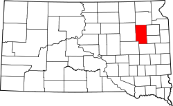
The town of Clark is located almost exactly in the geographical center of Clark County. The highest point in Clark County is located near the Township of Maydell, and the unnamed peak rises to 1,930 ft.

According to the United States Census Bureau, the city has a total area of 1.28 square miles (3.32 km2), all land. [10]

Demographics

Historical population
CensusPop.Note
1880 25
1890 5922,268.0%
1900 68415.5%
1910 1,22078.4%
1920 1,39214.1%
1930 1,290−7.3%
1940 1,2910.1%
1950 1,47113.9%
1960 1,4840.9%
1970 1,356−8.6%
1980 1,351−0.4%
1990 1,292−4.4%
2000 1,285−0.5%
2010 1,139−11.4%
2020 1,1480.8%
U.S. Decennial Census [11]
2018 Estimate [12] [4]

2010 census

As of the census [13] of 2010, there were 1,139 people, 552 households, and 306 families living in the city. The population density was 889.8 inhabitants per square mile (343.6/km2). There were 627 housing units at an average density of 489.8 per square mile (189.1/km2). The racial makeup of the city was 98.5% White, 0.1% African American, 0.2% Asian, 0.3% from other races, and 1.0% from two or more races. Hispanic or Latino of any race were 1.4% of the population.

There were 552 households, of which 19.2% had children under the age of 18 living with them, 46.4% were married couples living together, 6.0% had a female householder with no husband present, 3.1% had a male householder with no wife present, and 44.6% were non-families. 40.6% of all households were made up of individuals, and 24.1% had someone living alone who was 65 years of age or older. The average household size was 1.99 and the average family size was 2.68.

The median age in the city was 51.5 years. 18.8% of residents were under the age of 18; 3.7% were between the ages of 18 and 24; 20.1% were from 25 to 44; 24.8% were from 45 to 64; and 32.7% were 65 years of age or older. The gender makeup of the city was 47.1% male and 52.9% female.

2000 census

As of the census of 2000, there were 1,285 people, 558 households, and 334 families living in the city. The population density was 979.3 inhabitants per square mile (378.1/km2). There were 632 housing units at an average density of 481.6 per square mile (185.9/km2). The racial makeup of the city was 98.68% White, 0.23% African American, 0.39% Native American, 0.31% Asian, 0.08% from other races, and 0.31% from two or more races. Hispanic or Latino of any race were 0.31% of the population.

There were 558 households, out of which 24.0% had children under the age of 18 living with them, 50.7% were married couples living together, 6.6% had a female householder with no husband present, and 40.1% were non-families. 37.5% of all households were made up of individuals, and 24.2% had someone living alone who was 65 years of age or older. The average household size was 2.19 and the average family size was 2.90.

In the city, the population was spread out, with 22.8% under the age of 18, 4.4% from 18 to 24, 19.9% from 25 to 44, 23.1% from 45 to 64, and 29.7% who were 65 years of age or older. The median age was 47 years. For every 100 females, there were 84.1 males. For every 100 females age 18 and over, there were 80.4 males.

As of 2000 the median income for a household in the city was $29,432, and the median income for a family was $39,167. Males had a median income of $26,771 versus $17,868 for females. The per capita income for the city was $14,758. About 6.3% of families and 9.1% of the population were below the poverty line, including 7.0% of those under age 18 and 18.8% of those age 65 or over.

Notable people

See also

Related Research Articles

<span class="mw-page-title-main">Clark County, South Dakota</span> County in South Dakota, United States

Clark County is a county in the U.S. state of South Dakota. As of the 2020 census, the population was 3,837. Its county seat is Clark. The county was created in 1873 and organized in 1881. It was named for Newton Clark, a Dakota Territory legislator in 1873.

<span class="mw-page-title-main">Washburn, North Dakota</span> City in North Dakota, United States

Washburn is a city in southern McLean County, North Dakota, United States. Located along the upper Missouri River, it is the county seat of McLean County. The population was 1,300 at the 2020 census.

<span class="mw-page-title-main">Springfield, South Dakota</span> City in South Dakota, United States

Springfield is a city in Bon Homme County, South Dakota, United States. The population was 1,914 at the 2020 census. As of 2012, about 1,200 of the residents were inmates at Mike Durfee State Prison.

<span class="mw-page-title-main">Tyndall, South Dakota</span> City in South Dakota, United States

Tyndall is a city in and the county seat of Bon Homme County, South Dakota, United States. The population was 1,057 at the 2020 census.

<span class="mw-page-title-main">Platte, South Dakota</span> City in South Dakota, United States

Platte is a city in Charles Mix County, South Dakota, United States. The population was 1,311 at the 2022 census. The community is named after the Platte Creek, a tributary of the Missouri River reservoir Lake Francis Case. Platte is located 15 miles east of Lake Francis Case on the Missouri River.

<span class="mw-page-title-main">Wagner, South Dakota</span> City in South Dakota, United States

Wagner is a city in Charles Mix County, South Dakota, United States. The population was 1,490 at the 2020 census. The city is served by Wagner Municipal Airport as well as YST Transit buses.

<span class="mw-page-title-main">Garden City, South Dakota</span> Town in South Dakota, United States

Garden City is a town in Clark County, South Dakota, United States. The population was 33 at the 2020 census.

<span class="mw-page-title-main">Willow Lake, South Dakota</span> City in South Dakota, United States

Willow Lake is a city in Clark County, South Dakota, United States. The population was 255 at the 2020 census.

<span class="mw-page-title-main">Webster, South Dakota</span> City in South Dakota, United States

Webster is a city in and the county seat of Day County, South Dakota, United States. The population was 1,728 at the 2020 census.

<span class="mw-page-title-main">Clear Lake, South Dakota</span> City in South Dakota, United States

Clear Lake is a city in and the county seat of Deuel County, South Dakota, United States. The population was 1,218 at the 2020 census.

<span class="mw-page-title-main">Faulkton, South Dakota</span> City in South Dakota, United States

Faulkton is a city in and county seat of Faulk County, South Dakota, United States. The population was 826 at the 2020 census. The city's nickname is "The Carousel City".

<span class="mw-page-title-main">Gregory, South Dakota</span> City in South Dakota, United States

Gregory is a city in western Gregory County, South Dakota, United States. The population was 1,221 at the 2020 census.

<span class="mw-page-title-main">Miller, South Dakota</span> City in South Dakota, United States

Miller is a city in and county seat of Hand County, South Dakota, United States. The population was 1,349 at the 2020 census.

<span class="mw-page-title-main">Parkston, South Dakota</span> City in South Dakota, United States

Parkston is a city in Hutchinson County, South Dakota, United States. The population was 1,567 at the 2020 census.

<span class="mw-page-title-main">Sturgis, South Dakota</span> City in South Dakota, United States

Sturgis is a city in Meade County, South Dakota, United States. The population was 7,020 as of the 2020 census. It is the county seat of Meade County and is named after Samuel D. Sturgis, a Union general during the Civil War.

<span class="mw-page-title-main">Crooks, South Dakota</span> City in South Dakota, United States

Crooks is a city in Minnehaha County, South Dakota, United States and is a suburb of Sioux Falls. The population was 1,362 at the 2020 census. Crooks was named New Hope until 1904. The town's present name honors W. A. Crooks, a local politician.

<span class="mw-page-title-main">Mission, South Dakota</span> City in South Dakota, United States

Mission is a city on the Rosebud Indian Reservation in northern Todd County, South Dakota, United States. The population was 1,156 at the 2020 census.

<span class="mw-page-title-main">Parker, South Dakota</span> City in South Dakota, U.S.

Parker is a city in Turner County, South Dakota, United States. The population was 1,194 at the 2020 census. It is the county seat of Turner County. Parker is bordered on its eastern side by South Dakota State Highway 19. Its northern side is bordered by South Dakota State Highway 44. Parker is located approximately 8 miles (13 km) northwest of Chancellor, 42 miles (68 km) east of Parkston and 41 miles (66 km) south of Madison.

<span class="mw-page-title-main">Elk Point, South Dakota</span> City in South Dakota, United States

Elk Point is a city in and county seat of Union County, South Dakota, United States. The population was 2,149 as of the 2020 census.

<span class="mw-page-title-main">Irene, South Dakota</span> City in South Dakota, United States

Irene is a city in Clay, Turner, and Yankton counties in South Dakota, United States. The population was 422 at the 2020 census. The portion of Irene that is located in Turner County is a part of the Sioux Falls, South Dakota metropolitan area, the portion located in Yankton County is part of the Yankton Micropolitan Statistical Area, and the portion located in Clay County is part of both the Vermillion Micropolitan Statistical Area and the Sioux City-Vermillion Combined Statistical Area. Irene is also host to the Irene Rodeo, held every summer.

References

  1. "SD Towns" (PDF). South Dakota State Historical Society. Archived from the original (PDF) on February 10, 2010. Retrieved February 11, 2010.
  2. "ArcGIS REST Services Directory". United States Census Bureau. Retrieved October 15, 2022.
  3. 1 2 U.S. Geological Survey Geographic Names Information System: Clark, South Dakota
  4. 1 2 "Census Population API". United States Census Bureau. Retrieved October 15, 2022.
  5. "U.S. Census Bureau: Clark city, South Dakota". www.census.gov. United States Census Bureau. Retrieved April 16, 2022.
  6. "Clark County". Jim Forte Postal History. Retrieved February 28, 2015.
  7. 1 2 Chicago and North Western Railway Company (1908). A History of the Origin of the Place Names Connected with the Chicago & North Western and Chicago, St. Paul, Minneapolis & Omaha Railways. p. 57.
  8. Federal Writers' Project (1940). South Dakota place-names, v.1-3. University of South Dakota. p. 30.
  9. Christenson, Robert (February 1, 2019). Clark Stories. RBC Consulting, LLC. p. 404. ISBN   9781387384556.
  10. "US Gazetteer files 2010". United States Census Bureau. Archived from the original on January 25, 2012. Retrieved June 21, 2012.
  11. United States Census Bureau. "Census of Population and Housing" . Retrieved July 15, 2014.
  12. "Population and Housing Unit Estimates". United States Census Bureau. June 27, 2019. Retrieved June 4, 2019.
  13. "U.S. Census website". United States Census Bureau . Retrieved June 21, 2012.