Crocker, South Dakota

Last updated

Crocker, South Dakota
USA South Dakota location map.svg
Red pog.svg
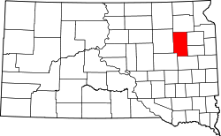
Crocker
Location in South Dakota
Coordinates: 45°06′25″N97°46′50″W / 45.10694°N 97.78056°W / 45.10694; -97.78056
Country United States
State South Dakota
County Clark
Area
[1]
  Total3.93 sq mi (10.19 km2)
  Land3.63 sq mi (9.40 km2)
  Water0.31 sq mi (0.80 km2)
Elevation
[2]
1,798 ft (548 m)
Population
 (2020) [3]
  Total19
  Density5.24/sq mi (2.02/km2)
Time zone UTC-6 (Central (CST))
  Summer (DST) UTC-5 (CDT)
Area code 605
FIPS code 46-14660 [4]
GNIS feature ID2628842 [2]

Crocker is an unincorporated community and census-designated place (CDP) in Clark County, South Dakota, United States. The population was 19 at the 2020 census. [5]

Contents

Crocker was laid out in 1906. [6]

Geography

Crocker is located in northern Clark County along South Dakota Highway 20, which leads east and southeast 40 miles (64 km) to Watertown and west 19 miles (31 km) to Conde.

According to the United States Census Bureau, the Crocker CDP has a total area of 3.9 square miles (10.2 km2), of which 3.6 square miles (9.4 km2) is land and 0.3 square miles (0.8 km2), or 7.83%, is water. [4]

Demographics

Historical population
CensusPop.Note
2020 19
U.S. Decennial Census [7]

Related Research Articles

<span class="mw-page-title-main">La Plant, South Dakota</span> Census-designated place in South Dakota, United States

La Plant is a census-designated place (CDP) in Dewey County, South Dakota, United States. The population was 167 at the 2020 census. It is within the Cheyenne River Indian Reservation.

<span class="mw-page-title-main">North Eagle Butte, South Dakota</span> Census-designated place in South Dakota, United States

North Eagle Butte is a census-designated place (CDP) in Dewey County, South Dakota, United States, along the 45th parallel. The population was 1,879 at the 2020 census.

<span class="mw-page-title-main">Harrison, South Dakota</span> Census-designated place in South Dakota, United States

Harrison is an unincorporated community and census-designated place (CDP) in Douglas County, South Dakota, United States. The population was 55 at the 2020 census.

<span class="mw-page-title-main">Wanblee, South Dakota</span> Census-designated place in South Dakota, United States

Wanblee is a census-designated place on the Pine Ridge Indian Reservation, located in Jackson County, South Dakota, United States. The population was 674 at the 2020 census, virtually all of whom are members of the Oglala band of Lakota Sioux. Wanbli is the Lakota word for eagle, and the town was named for its proximity to Wanbli hohpi paha. Wanblee is a few miles directly northeast of the North American continental pole of inaccessibility.

<span class="mw-page-title-main">North Spearfish, South Dakota</span> Census-designated place in South Dakota, United States

North Spearfish is a census-designated place (CDP) in Lawrence County, South Dakota, United States. The population was 2,366 at the 2020 census.

<span class="mw-page-title-main">Vivian, South Dakota</span> Census-designated place in South Dakota, United States

Vivian is an unincorporated community and census-designated place (CDP) in Lyman County, South Dakota, United States. The population was 98 at the 2020 census.

<span class="mw-page-title-main">Ashland Heights, South Dakota</span> CDP in South Dakota, United States

Ashland Heights is a census-designated place (CDP) and unincorporated community in Pennington County, South Dakota, United States. The population was 678 at the 2020 census.

<span class="mw-page-title-main">Oglala, South Dakota</span> CDP in South Dakota, United States

Oglala is a census-designated place (CDP) in West Oglala Lakota Unorganized Territory equivalent, Oglala Lakota County, South Dakota, United States. The population was 1,282 at the 2020 census. Its location is in the northwest of the Pine Ridge Indian Reservation.

<span class="mw-page-title-main">Pine Ridge, South Dakota</span> CDP in South Dakota, United States

Pine Ridge is a census-designated place (CDP) and the most populous community in Oglala Lakota County, South Dakota, United States. The population was 3,138 at the 2020 census. It is the tribal headquarters of the Oglala Sioux Tribe on the Pine Ridge Indian Reservation.

Chester is an unincorporated community and census-designated place (CDP) in Lake County, South Dakota, United States. The population was 257 as of the 2020 census. Chester has been assigned the ZIP code of 57016.

Saint Onge is an unincorporated community and census-designated place (CDP) in Lawrence County, South Dakota, United States. As of the 2020 census, the population was 170.

Winfred is an unincorporated community and census-designated place (CDP) in Lake County, South Dakota, United States, approximately 12 miles (19 km) west of Madison. The population was 38 as of the 2020 census.

Shindler is an unincorporated community and census-designated place (CDP) in Lincoln County, South Dakota, United States. The population was 607 at the 2020 census.

Morningside is a census-designated place (CDP) in Beadle County, South Dakota, United States. The population was 70 at the 2020 census.

<span class="mw-page-title-main">Running Water, South Dakota</span> Census-designated place in South Dakota, United States

Running Water is a census-designated place (CDP) in Bon Homme County, South Dakota, United States. The population was 47 at the 2020 census.

Lake Poinsett is a census-designated place (CDP) in Hamlin and Brookings counties in South Dakota, United States. The population was 501 at the 2020 census.

<span class="mw-page-title-main">Wiscasset (CDP), Maine</span> Census-designated place in Maine, United States

Wiscasset is a census-designated place (CDP) comprising the primary settlement in the town of Wiscasset in Lincoln County, Maine, United States. The population was 1,232 at the 2020 census, out of 3,732 people in the entire town. Wiscasset is the county seat of Lincoln County.

Waverly is an unincorporated community and census-designated place (CDP) in Codington County, South Dakota, United States. The population was 22 at the 2020 census.

Renner Corner is an unincorporated community and census-designated place in Minnehaha County, South Dakota, United States. Its population was 347 as of the 2020 census. The community is located along South Dakota Highway 115, north of Sioux Falls.

Lake Madison is an unincorporated community and census-designated place in Lake County, South Dakota, United States. Its population was 829 as of the 2020 census. The community is located on the shores of Lake Madison.

References

  1. "ArcGIS REST Services Directory". United States Census Bureau. Retrieved October 15, 2022.
  2. 1 2 U.S. Geological Survey Geographic Names Information System: Crocker, South Dakota
  3. "Census Population API". United States Census Bureau. Retrieved October 15, 2022.
  4. 1 2 "Geographic Identifiers: 2010 Census Summary File 1 (G001): Crocker CDP, South Dakota". U.S. Census Bureau, American Factfinder. Archived from the original on February 13, 2020. Retrieved July 2, 2015.
  5. "U.S. Census Bureau: Crocker CDP, South Dakota". www.census.gov. United States Census Bureau. Retrieved April 16, 2022.
  6. Federal Writers' Project (1940). South Dakota place-names, v.1-3. University of South Dakota. p. 32.
  7. "Census of Population and Housing". Census.gov. Retrieved June 4, 2016.