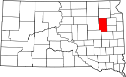
Garden City, South Dakota | |
---|---|
Town | |
Coordinates: 44°57′33″N97°34′49″W / 44.95917°N 97.58028°W | |
Country | United States |
State | South Dakota |
County | Clark |
Settled | 1889 [1] |
Area | |
• Total | 0.40 sq mi (1.02 km2) |
• Land | 0.40 sq mi (1.02 km2) |
• Water | 0.00 sq mi (0.00 km2) |
Elevation | 1,847 ft (563 m) |
Population | |
• Total | 33 |
• Density | 83.54/sq mi (32.29/km2) |
Time zone | UTC-6 (Central (CST)) |
• Summer (DST) | UTC-5 (CDT) |
ZIP code | 57236 |
Area code | 605 |
FIPS code | 46-23460 [5] |
GNIS feature ID | 1267399 [3] |
Garden City is a town in Clark County, South Dakota, United States. The population was 33 at the 2020 census. [6]
Garden City was first settled in 1882, but it was in 1887 that Garden City was established as this was the year that the Chicago Milwaukee & St. Paul Railroad came through. [7] The town was named from the site's garden-like setting. [8]
According to the United States Census Bureau, the town has a total area of 0.40 square miles (1.04 km2), all land. [9]
Climate data for Garden City, South Dakota | |||||||||||||
---|---|---|---|---|---|---|---|---|---|---|---|---|---|
Month | Jan | Feb | Mar | Apr | May | Jun | Jul | Aug | Sep | Oct | Nov | Dec | Year |
Record high °F (°C) | 66 (19) | 67 (19) | 85 (29) | 95 (35) | 107 (42) | 108 (42) | 110 (43) | 108 (42) | 104 (40) | 96 (36) | 78 (26) | 63 (17) | 110 (43) |
Mean daily maximum °F (°C) | 22 (−6) | 27 (−3) | 39 (4) | 55 (13) | 67 (19) | 76 (24) | 83 (28) | 81 (27) | 71 (22) | 57 (14) | 39 (4) | 25 (−4) | 54 (12) |
Daily mean °F (°C) | 13 (−11) | 18 (−8) | 29 (−2) | 44 (7) | 56 (13) | 66 (19) | 72 (22) | 70 (21) | 60 (16) | 46 (8) | 30 (−1) | 16 (−9) | 43 (6) |
Mean daily minimum °F (°C) | 3 (−16) | 8 (−13) | 19 (−7) | 32 (0) | 45 (7) | 55 (13) | 61 (16) | 58 (14) | 48 (9) | 35 (2) | 21 (−6) | 7 (−14) | 33 (0) |
Record low °F (°C) | −42 (−41) | −40 (−40) | −27 (−33) | −8 (−22) | 16 (−9) | 28 (−2) | 38 (3) | 32 (0) | 15 (−9) | −8 (−22) | −22 (−30) | −35 (−37) | −42 (−41) |
Average precipitation inches (mm) | 0.53 (13) | 0.60 (15) | 1.24 (31) | 1.97 (50) | 2.94 (75) | 3.92 (100) | 3.50 (89) | 2.82 (72) | 2.78 (71) | 2.06 (52) | 0.92 (23) | 0.54 (14) | 23.82 (605) |
Source: The Weather Channel (Historical Monthly Averages) [10] |
Census | Pop. | Note | %± |
---|---|---|---|
1910 | 304 | — | |
1920 | 204 | −32.9% | |
1930 | 257 | 26.0% | |
1940 | 272 | 5.8% | |
1950 | 282 | 3.7% | |
1960 | 226 | −19.9% | |
1970 | 126 | −44.2% | |
1980 | 104 | −17.5% | |
1990 | 93 | −10.6% | |
2000 | 72 | −22.6% | |
2010 | 53 | −26.4% | |
2020 | 33 | −37.7% | |
U.S. Decennial Census [11] [4] |
As of the census [12] of 2010, there were 53 people, 21 households, and 17 families residing in the town. The population density was 132.5 inhabitants per square mile (51.2/km2). There were 35 housing units at an average density of 87.5 per square mile (33.8/km2). The racial makeup of the town was 94.3% White and 5.7% from two or more races. Hispanic or Latino of any race were 5.7% of the population.
There were 21 households, of which 28.6% had children under the age of 18 living with them, 61.9% were married couples living together, 9.5% had a female householder with no husband present, 9.5% had a male householder with no wife present, and 19.0% were non-families. 19.0% of all households were made up of individuals, and 4.8% had someone living alone who was 65 years of age or older. The average household size was 2.52 and the average family size was 2.82.
The median age in the town was 48.2 years. 26.4% of residents were under the age of 18; 1.8% were between the ages of 18 and 24; 11.4% were from 25 to 44; 39.6% were from 45 to 64; and 20.8% were 65 years of age or older. The gender makeup of the town was 52.8% male and 47.2% female.
As of the census [5] of 2000, there were 72 people, 31 households, and 19 families residing in the town. The population density was 182.1 inhabitants per square mile (70.3/km2). There were 46 housing units at an average density of 116.3 per square mile (44.9/km2). The racial makeup of the town was 100.00% White.
There were 31 households, out of which 25.8% had children under the age of 18 living with them, 54.8% were married couples living together, and 38.7% were non-families. 38.7% of all households were made up of individuals, and 25.8% had someone living alone who was 65 years of age or older. The average household size was 2.32 and the average family size was 3.16.
In the town, the population was spread out, with 26.4% under the age of 18, 2.8% from 18 to 24, 25.0% from 25 to 44, 19.4% from 45 to 64, and 26.4% who were 65 years of age or older. The median age was 42 years. For every 100 females, there were 111.8 males. For every 100 females age 18 and over, there were 112.0 males.
The median income for a household in the town was $31,875, and the median income for a family was $38,750. Males had a median income of $23,750 versus $21,250 for females. The per capita income for the town was $14,014. There were 9.5% of families and 12.5% of the population living below the poverty line, including no under eighteens and 33.3% of those over 64.
Mound City is a town in and the county seat of Campbell County, South Dakota, United States. The population was 69 at the 2020 census.
Wagner is a city in Charles Mix County, South Dakota, United States. The population was 1,490 at the 2020 census. The city is served by Wagner Municipal Airport as well as YST Transit buses.
Florence is a town in northwestern Codington County, South Dakota, United States. It is part of the Watertown, South Dakota Micropolitan Statistical Area. The population was 337 at the 2020 census.
Bristol is a city located in western Day County, South Dakota, United States. It lies in Section 25 of Bristol Township, on the main line of what is now the BNSF Railway alongside U.S. Route 12. The population was 288 at the 2020 census.`
Clear Lake is a city in and the county seat of Deuel County, South Dakota, United States. The population was 1,218 at the 2020 census.
Corsica is a city in Douglas County, South Dakota, United States. The population was 561 at the 2020 census.
Parkston is a city in Hutchinson County, South Dakota, United States. The population was 1,567 at the 2020 census.
Kadoka is a city in, and the county seat of, Jackson County, South Dakota, United States. The population was 543 at the 2020 census. The town occupies about 2.3 square miles.
Central City is a city in Lawrence County, South Dakota, United States. The population was 93 at the 2020 census.
Lennox is a city in Lincoln County, South Dakota, United States, located 20 miles (32 km) southwest of Sioux Falls. The population was 2,423 at the 2020 census.
Presho is a small city in Lyman County, South Dakota, United States. The population was 472 at the 2020 census.
Lake City is a town in Marshall County, South Dakota, United States. The population was 45 at the 2020 census. Fort Sisseton Historic State Park, whose fort is listed on the National Register of Historic Places, is located nearby.
Leola is a small city in, and the county seat of, McPherson County, South Dakota, United States. It was founded on May 1, 1884, and named for Leola Haynes, daughter of one of the town's founders. The population was 434 as of the 2020 census.
Carthage is a city in Miner County, South Dakota, United States. The population was 127 at the 2020 census.
Crooks is a city in Minnehaha County, South Dakota, United States and is a suburb of Sioux Falls. The population was 1,362 at the 2020 census. Crooks was named New Hope until 1904. The town's present name honors W. A. Crooks, a local politician.
Hartford is a suburban American city in Minnehaha County, South Dakota, a few miles northwest of Sioux Falls. Its population was 3,354 at the 2020 census.
Wilmot is a city in Roberts County, South Dakota, United States. The population was 432 at the 2020 census.
Woonsocket is a city in Sanborn County, South Dakota. The population was 631 at the 2020 census. It is the county seat of Sanborn County.
Ashton is a city in eastern Spink County, South Dakota, United States. The population was 108 at the 2020 census.
Eagle Butte is a city in Dewey and Ziebach counties in South Dakota, United States. The population was 1,258 at the 2020 census. It is adjacent to the North Eagle Butte CDP.