Collins Colony, South Dakota | |
|---|---|
 Collins Colony  Collins Colony | |
| Coordinates: 44°32′52″N97°42′05″W / 44.54778°N 97.70139°W | |
| Country | United States |
| State | South Dakota |
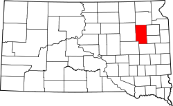
| County | Clark |
| Area | |
• Total | 0.33 sq mi (0.86 km2) |
| • Land | 0.33 sq mi (0.86 km2) |
| • Water | 0 sq mi (0.00 km2) |
| Elevation | 1,749 ft (533 m) |
| Population | |
• Total | 92 |
| • Density | 277.3/sq mi (107.06/km2) |
| Time zone | UTC-6 (Central (CST)) |
| • Summer (DST) | UTC-5 (CDT) |
| ZIP Code | 57353 (Iroquois) |
| Area code | 605 |
| FIPS code | 46-13188 |
| GNIS feature ID | 2813008 [2] |
Collins Colony is a Hutterite colony [4] and census-designated place (CDP) in Clark County, South Dakota, United States. The population was 92 at the 2020 census. [5] It was first listed as a CDP prior to the 2020 census. [2]
It is on the southern edge of the county, bordered to the south by Kingsbury County. It is 20 miles (32 km) northeast of Iroquois and 25 miles (40 km) south of Clark, the Clark county seat.