Dell Rapids, South Dakota

Last updated

Dell Rapids
Dell Rapids, South Dakota
Dell Rapids, South Dakota 1.jpg
Sioux Quartzite was used in the reconstruction of downtown Dell Rapids after a fire burned down the wooden buildings in the 1880s.
Nickname: 
"The Little City with the Big Attractions"
Minnehaha County South Dakota Incorporated and Unincorporated areas Dell Rapids Highlighted.svg
Location in Minnehaha County and the state of South Dakota
Coordinates: 43°49′28″N96°42′52″W / 43.82444°N 96.71444°W / 43.82444; -96.71444
Country United States
State South Dakota
County Minnehaha
Founded1871 [1]
Incorporated1888 [2]
Government
   Mayor Tom Earley [3]
Area
[4]
  Total2.32 sq mi (6.02 km2)
  Land2.25 sq mi (5.84 km2)
  Water0.07 sq mi (0.18 km2)
Elevation
[5]
1,539 ft (469 m)
Population
 (2020) [6]
  Total3,996
  Density1,772.85/sq mi (684.39/km2)
Time zone UTC−6 (Central (CST))
  Summer (DST) UTC−5 (CDT)
ZIP code
57022
Area code 605
FIPS code 46-15980
GNIS feature ID1267351 [5]
Website City of Dell Rapids

Dell Rapids is a city in Minnehaha County, South Dakota, United States. The population was 3,996 at the 2020 census. [7] It is known as "The Little City with the Big Attractions."

Contents

The city took its name from the Dells of the Wisconsin River, which were likened to the local rapids on the Big Sioux River. [8]

History

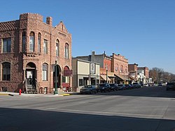
Dell Rapids was originally named Dell City, but was renamed after the rapids of the Big Sioux River. [8] After a fire broke out on the main street and burned most of the town, it was rebuilt out of Sioux Quartzite, [8] a common rock in the area. The Chicago, Milwaukee, and Saint Paul Railroad built a railroad into the area, reaching Dell Rapids from Egan in 1881. Two large Sioux Quartzite quarries owned by LG Everist are operated via this rail line, which is now operated by LG's subsidiary, the D&I Railroad. The community celebrates its heritage with the annual "Quarry Days" in July, and in June, the city hosts "Cootie Days", where rides and games are set up and available in the city's park.

Geography

Dell Rapids is located along the Big Sioux River. [9]

According to the United States Census Bureau, the city has an area of 2.09 square miles (5.41 km2), of which 2.03 square miles (5.26 km2) is land and 0.06 square miles (0.16 km2) is water. [10]

Demographics

Historical population
CensusPop.Note
1880 260
1890 993281.9%
1900 1,25526.4%
1910 1,3678.9%
1920 1,67722.7%
1930 1,657−1.2%
1940 1,7063.0%
1950 1,650−3.3%
1960 1,86312.9%
1970 1,9916.9%
1980 2,38920.0%
1990 2,4844.0%
2000 2,98020.0%
2010 3,63321.9%
2020 3,99610.0%
U.S. Decennial Census [11]
2017 Estimate [12] [6]

2010 census

At the 2010 census there were 3,633 people, 1,388 households, and 973 families living in the city. The population density was 1,789.7 inhabitants per square mile (691.0/km2). There were 1,495 housing units at an average density of 736.5 per square mile (284.4/km2). The racial makeup of the city was 98.0% White, 0.1% African American, 0.6% Native American, 0.2% Asian, 0.2% from other races, and 0.9% from two or more races. Hispanic or Latino of any race were 1.4%. [13]

Of the 1,388 households 38.3% had children under the age of 18 living with them, 58.8% were married couples living together, 7.8% had a female householder with no husband present, 3.5% had a male householder with no wife present, and 29.9% were non-families. 25.1% of households were one person and 11.4% were one person aged 65 or older. The average household size was 2.58 and the average family size was 3.10.

The median age was 34.8 years. 28.9% of residents were under the age of 18; 6.6% were between the ages of 18 and 24; 27.6% were from 25 to 44; 21.7% were from 45 to 64; and 15% were 65 or older. The gender makeup of the city was 48.7% male and 51.3% female.

2000 census

At the 2000 census, there were 2,980 people, 1,127 households, and 793 families living in the city. The population density was 1,519.9 inhabitants per square mile (586.8/km2). There were 1,181 housing units at an average density of 602.3 per square mile (232.5/km2). The racial makeup of the city was 98.69% White, 0.13% African American, 0.47% Native American, 0.20% Asian, 0.07% from other races, and 0.44% from two or more races. Hispanic or Latino of any race were 0.64% of the population.

Of the 1,127 households 36.7% had children under the age of 18 living with them, 60.5% were married couples living together, 7.2% had a female householder with no husband present, and 29.6% were non-families. 26.0% of households were one person and 13.5% were one person aged 65 or older. The average household size was 2.55 and the average family size was 3.09.

The age distribution was 28.4% under the age of 18, 6.5% from 18 to 24, 27.3% from 25 to 44, 19.4% from 45 to 64, and 18.3% 65 or older. The median age was 36 years. For every 100 females, there were 91.4 males. For every 100 females age 18 and over, there were 90.3 males.

As of 2000 the median income for a household in the city was $42,572, and the median family income was $49,536. Males had a median income of $31,867 versus $24,333 for females. The per capita income for the city was $17,731. About 1.9% of families and 4.0% of the population were below the poverty line, including 2.3% of those under age 18 and 12.7% of those age 65 or over.

Education

Dell Rapids is home to two separate school systems: the Dell Rapids public school system and St. Mary's, a private Catholic parochial school.

The public school system includes Dell Rapids High School, a middle school, and an elementary school. The Public School District's mascot is the Quarriers, named after the large Sioux Quartzite rock quarries that are also in Dell Rapids. St. Mary's school also includes St. Mary High School, a junior high school, and elementary school. The St. Mary School District's mascot is the Cardinals.

Notable people

Related Research Articles

<span class="mw-page-title-main">Minnehaha County, South Dakota</span> County in South Dakota, United States

Minnehaha County is a county on the eastern border of the state of South Dakota. As of the 2020 census, the population was 197,214, making it the state's most populous county. It contains over 20% of the state's population. Its county seat is Sioux Falls, South Dakota's largest city. The county was created in 1862 and organized in 1868. Its name was derived from the Sioux word Mnihaha, meaning "rapid water," or "waterfall".

<span class="mw-page-title-main">Rembrandt, Iowa</span> City in Iowa, United States

Rembrandt is a city in Buena Vista County, Iowa, United States. The population was 209 at the time of the 2020 census.

<span class="mw-page-title-main">Sioux Rapids, Iowa</span> City in Iowa, United States

Sioux Rapids is a city in Buena Vista County, Iowa, United States. The population was 748 at the time of the 2020 census.

<span class="mw-page-title-main">Peterson, Iowa</span> City in Iowa, United States

Peterson is a city in Clay County, Iowa, United States. The population was 322 in the 2020 census, a decline from 372 in 2000.

<span class="mw-page-title-main">South Sioux City, Nebraska</span> City in Dakota County, Nebraska, United States

South Sioux City is a city in Dakota County, Nebraska, United States. It is located immediately across the Missouri River from Sioux City, Iowa, and is part of the Sioux City, IA-NE-SD Metropolitan Statistical Area. As of the 2010 census, the city population was 13,353, making it the 14th largest city in Nebraska.

<span class="mw-page-title-main">Volga, South Dakota</span> City in South Dakota, United States

Volga is a city in Brookings County, South Dakota, United States with a population of 2,113 at the 2020 census.

<span class="mw-page-title-main">Lake Andes, South Dakota</span> City in South Dakota, United States

Lake Andes is a city in, and the county seat of, Charles Mix County, South Dakota, United States. The population was 710 at the 2020 census.

<span class="mw-page-title-main">Lennox, South Dakota</span> City in South Dakota, United States

Lennox is a city in Lincoln County, South Dakota, United States, located 20 miles (32 km) southwest of Sioux Falls. The population was 2,423 at the 2020 census.

<span class="mw-page-title-main">Tea, South Dakota</span> City in South Dakota, United States

Tea is a city in Lincoln County, South Dakota, United States and is a suburb of Sioux Falls. The population was 5,598 at the 2020 census.

<span class="mw-page-title-main">Baltic, South Dakota</span> City in South Dakota, United States

Baltic is a city on the Big Sioux River in northern Minnehaha County, South Dakota, United States. The population was 1,246 at the 2020 census.

<span class="mw-page-title-main">Crooks, South Dakota</span> City in South Dakota, United States

Crooks is a city in Minnehaha County, South Dakota, United States and is a suburb of Sioux Falls. The population was 1,362 at the 2020 census. Crooks was named New Hope until 1904. The town's present name honors W. A. Crooks, a local politician.

<span class="mw-page-title-main">Flandreau, South Dakota</span> City in South Dakota, United States

FlandreauFLAN-droo is a city in and county seat of Moody County, South Dakota, United States. The population was 2,372 at the 2020 census. It was named in honor of Charles Eugene Flandrau, a judge in the territory and state of Minnesota. He is credited with saving the community of New Ulm, Minnesota, from destruction during conflict with the Sioux tribe in 1862.

<span class="mw-page-title-main">Oglala, South Dakota</span> CDP in South Dakota, United States

Oglala is a census-designated place (CDP) in West Oglala Lakota Unorganized Territory equivalent, Oglala Lakota County, South Dakota, United States. The population was 1,282 at the 2020 census. Its location is in the northwest of the Pine Ridge Indian Reservation.

<span class="mw-page-title-main">Mission, South Dakota</span> City in South Dakota, United States

Mission is a city on the Rosebud Indian Reservation in northern Todd County, South Dakota, United States. The population was 1,156 at the 2020 census.

<span class="mw-page-title-main">Alcester, South Dakota</span> City in South Dakota, United States

Alcester is a city in northern Union County, South Dakota, United States. It is part of the Sioux City, IA–NE–SD Metropolitan Statistical Area. The population was 820 at the 2020 census.

<span class="mw-page-title-main">Elk Point, South Dakota</span> City in South Dakota, United States

Elk Point is a city in and county seat of Union County, South Dakota, United States. The population was 2,149 as of the 2020 census.

<span class="mw-page-title-main">North Sioux City, South Dakota</span> City in South Dakota, United States

North Sioux City is a city in Union County, South Dakota, United States. The population was 3,042 at the 2020 census. It is part of the Sioux City, IA-NE-SD Metropolitan Statistical Area.

<span class="mw-page-title-main">Irene, South Dakota</span> City in South Dakota, United States

Irene is a city in Clay, Turner, and Yankton counties in South Dakota, United States. The population was 422 at the 2020 census. The portion of Irene that is located in Turner County is a part of the Sioux Falls, South Dakota metropolitan area, the portion located in Yankton County is part of the Yankton Micropolitan Statistical Area, and the portion located in Clay County is part of both the Vermillion Micropolitan Statistical Area and the Sioux City-Vermillion Combined Statistical Area. Irene is also host to the Irene Rodeo, held every summer.

<span class="mw-page-title-main">Eagle Butte, South Dakota</span> City in South Dakota, United States

Eagle Butte is a city in Dewey and Ziebach counties in South Dakota, United States. The population was 1,258 at the 2020 census.

<span class="mw-page-title-main">Weyauwega, Wisconsin</span> City in Wisconsin, United States

Weyauwega is a city in Waupaca County, Wisconsin, United States. The population was 1,900 at the 2010 census. The city is located mostly within the Town of Weyauwega, though it is politically independent of the town. Small portions extend north into the adjacent Town of Royalton. The city is commonly referred to as "Wega" by local residents. The name "Weyauwega" is described by the Weyauwega Chamber of Commerce as potentially meaning "Here we rest" in a local indigenous language because the town's origin was a stopping/resting point between two rivers when Native Americans had to portage their canoes. Given the local indigenous culture is described as Menominee the language may be the Menominee language if this etymology for Weyauwega is correct.

References

  1. Thompson (ed.), p. 167.
  2. "SD Towns" (PDF). South Dakota State Historical Society. Archived from the original (PDF) on February 10, 2010. Retrieved February 11, 2010.
  3. "Welcome to Dell Rapids, SD". cityofdellrapids.org. Retrieved January 5, 2020.
  4. "ArcGIS REST Services Directory". United States Census Bureau. Retrieved October 15, 2022.
  5. 1 2 U.S. Geological Survey Geographic Names Information System: Dell Rapids, South Dakota
  6. 1 2 "Census Population API". United States Census Bureau. Retrieved October 15, 2022.
  7. "U.S. Census Bureau: Dell Rapids city, South Dakota". www.census.gov. United States Census Bureau. Retrieved February 21, 2022.
  8. 1 2 3 Federal Writers' Project (1940). South Dakota place-names, v.1-3. American guide series. University of South Dakota. p. 34.
  9. DeLorme (2001), South Dakota Atlas & Gazetteer, Yarmouth, Maine: DeLorme, ISBN   0-89933-330-3
  10. "US Gazetteer files 2010". United States Census Bureau. Archived from the original on January 25, 2012. Retrieved June 21, 2012.
  11. United States Census Bureau. "Census of Population and Housing" . Retrieved September 23, 2013.
  12. "Population Estimates". United States Census Bureau. Archived from the original on September 22, 2018. Retrieved October 5, 2018.
  13. "U.S. Census website". United States Census Bureau . Retrieved June 21, 2012.

Bibliography