Piedmont, South Dakota

Last updated

Piedmont
USA South Dakota location map.svg
Red pog.svg
Piedmont
Location within the state of South Dakota
Coordinates: 44°13′02″N103°22′31″W / 44.21722°N 103.37528°W / 44.21722; -103.37528
Country United States
State South Dakota
County Meade
Founded1890
Incorporated2007
Named for French for "foot of the mountain"
Area
[1]
  Total1.56 sq mi (4.05 km2)
  Land1.56 sq mi (4.05 km2)
  Water0.00 sq mi (0.00 km2)
Elevation
[2]
3,583 ft (1,092 m)
Population
 (2020) [3]
  Total971
  Density620.84/sq mi (239.72/km2)
Time zone UTC-6 (Mountain Time Zone (MST))
  Summer (DST) UTC-5 (MDT)
ZIP codes
57769
Area code 605
FIPS code 46-49500
GNIS feature ID2547299 [2]
Website PiedmontSD.com

Piedmont is a city in Meade County, South Dakota, United States. [4] According to the 2020 census, its population was 971. [5] Piedmont lies along Interstate 90 between Rapid City and Sturgis. Piedmont has been assigned the ZIP Code of 57769. [6]

Contents

History

Piedmont takes its name from a French word meaning "the foot of the mountain", because it lies on the eastern slope of the Black Hills. [7] Piedmont was founded in 1890 and remained unincorporated for nearly 117 years. [8] It officially became a city August 16, 2007, and elected its first town board in November 2007. [8] [9] The area was first inhabited in the mid-1870s. [8]

Geography

Piedmont is located in part of an area referred to as the Red Valley, or Race Track, a rock layer in the Spearfish Formation, which forms a valley circling the Black Hills. [10] [11] It is mostly red shale with beds of gypsum. Piedmont lies west of Interstate 90, north of Summerset, east of the Black Hills National Forest, and south of Elk Creek.

According to the United States Census Bureau, the city has a total area of 0.29 square miles (0.75 km2), all land. [12]

Climate

Climate data for Piedmont, South Dakota
MonthJanFebMarAprMayJunJulAugSepOctNovDecYear
Record high °F (°C)73
(23)
78
(26)
81
(27)
90
(32)
99
(37)
105
(41)
107
(42)
104
(40)
103
(39)
92
(33)
83
(28)
74
(23)
107
(42)
Average high °F (°C)38
(3)
39
(4)
47
(8)
56
(13)
66
(19)
76
(24)
85
(29)
84
(29)
73
(23)
61
(16)
47
(8)
38
(3)
59
(15)
Average low °F (°C)13
(−11)
14
(−10)
22
(−6)
31
(−1)
42
(6)
51
(11)
58
(14)
56
(13)
45
(7)
34
(1)
23
(−5)
14
(−10)
34
(1)
Record low °F (°C)−25
(−32)
−28
(−33)
−19
(−28)
0
(−18)
19
(−7)
32
(0)
40
(4)
38
(3)
21
(−6)
−3
(−19)
−17
(−27)
−29
(−34)
−29
(−34)
Average precipitation inches (mm)0.19
(4.8)
0.35
(8.9)
0.85
(22)
2.01
(51)
3.86
(98)
2.61
(66)
2.57
(65)
2.14
(54)
1.47
(37)
1.49
(38)
0.51
(13)
0.32
(8.1)
18.37
(465.8)
Source: The Weather Channel (Historical Monthly Averages) [13]

Demographics

Historical population
CensusPop.Note
2010 222
2020 971337.4%
U.S. Decennial Census [14]
2018 Estimate [15] [3]

2010 census

As of the census [16] of 2010, 222 people, 101 households, and 64 families were residing in the city. The population density was 765.5 inhabitants per square mile (295.6/km2). The 110 housing units had an average density of 379.3 per square mile (146.4/km2). The racial makeup of the city was 91.4% White, 0.5% African American, 6.8% Native American, 0.5% from other races, and 0.9% from two or more races. Hispanics or Latinos of any race were 1.8% of the population.

Of the 101 households, 23.8% had children under 18 living with them, 53.5% were married couples, 5.9% had a female householder with no husband present, 4.0% had a male householder with no wife present, and 36.6% were not families. About 30.7% of all households were made up of individuals, and 12.9% had someone living alone who was 65 or older. The average household size was 2.20, and the average family size was 2.66.

The median age in the city was 43.8 years; 18.9% of residents were under the age of 18; 9.2% were between 18 and 24; 23.5% were from 25 to 44; 37% were from 45 to 64; and 11.7% were 65 or older. The gender makeup of the city was 52.3% male and 47.7% female.

Natural disasters

The Piedmont area has experienced several large forest fires in recent years, including the Little Elk in 2002, Ricco Fire in 2005, and Eastridge Fire in 2006. [17] [18] In August 2007 Piedmont experienced a significant storm, including softball-sized hail and heavy rain, which caused significant flooding and other damage to the city. [17] [19]

Economy

Many Piedmont area residents work in nearby Rapid City. Larger private employers include Mountain West Products, which processes bark from area sawmills into retail landscape products, High Plains Genetics, which provides genetic material to livestock producers, and Jack's Campers. Piedmont has numerous small businesses in tourism, transportation, and construction.

Related Research Articles

<span class="mw-page-title-main">South Dakota</span> U.S. state

South Dakota is a U.S. state in the North Central region of the United States. It is also part of the Great Plains. South Dakota is named after the Dakota Sioux Native American tribe, which comprises a large portion of the population with nine reservations currently in the state and have historically dominated the territory. South Dakota is the 17th largest by area, but the 5th least populous, and the 5th least densely populated of the 50 United States. As the southern part of the former Dakota Territory, South Dakota became a state on November 2, 1889, simultaneously with North Dakota. They are the 39th and 40th states admitted to the union; President Benjamin Harrison shuffled the statehood papers before signing them so that no one could tell which became a state first. Pierre is the state capital, and Sioux Falls, with a population of about 192,200, is South Dakota's most populous city.

<span class="mw-page-title-main">Union County, South Dakota</span> County in South Dakota, United States

Union County is the southernmost county in the U.S. state of South Dakota. As of the 2020 census, the population was 16,811, making it the 13th most populous county in South Dakota. Its county seat has been Elk Point since April 30, 1865. Originally named Cole County, its name was changed to Union on January 7, 1864, because of Civil War sentiment.

<span class="mw-page-title-main">Pennington County, South Dakota</span> County in South Dakota, United States

Pennington County is a county in the U.S. state of South Dakota. As of the 2020 census, the population was 109,222, making it the second-most populous county in South Dakota. Its county seat is Rapid City. The county was created in 1875, and was organized in 1877. It is named for John L. Pennington, fifth Governor of Dakota Territory, who held office in 1875 when the county was formed.

<span class="mw-page-title-main">Meade County, South Dakota</span> County in South Dakota, United States

Meade County is a county in the U.S. state of South Dakota. As of the 2020 census, the population was 29,852. Its county seat is Sturgis. The county was created in 1889 and named for Fort Meade, which was garrisoned as a United States military post in the area in 1878 and itself named for General George Meade.

<span class="mw-page-title-main">Jefferson County, Montana</span> County in Montana, United States

Jefferson County is a county in Montana, United States. As of the 2020 census, the population was 12,085. Its county seat is Boulder. The county was created in 1865 and named for President Thomas Jefferson.

<span class="mw-page-title-main">Belle Fourche, South Dakota</span> City in South Dakota, United States

Belle Fourche is a city in and the county seat of Butte County, South Dakota, United States. Its population was 5,617 at the 2020 census. It is near the geographic center of the United States, which moved some 550 miles northwest from the geographic center of the contiguous United States in Lebanon, Kansas with the admission of Alaska and Hawaii in the mid-20th century.

<span class="mw-page-title-main">Edgemont, South Dakota</span> City in South Dakota, United States

Edgemont is a city in Fall River County, South Dakota, United States. The population was 725 at the 2020 census. The city lies on the far southern edge of the Black Hills in southwestern South Dakota.

<span class="mw-page-title-main">Central City, South Dakota</span> City in South Dakota, United States

Central City is a city in Lawrence County, South Dakota, United States. The population was 93 at the 2020 census.

<span class="mw-page-title-main">Deadwood, South Dakota</span> City in South Dakota, United States

Deadwood is a city that serves as county seat of Lawrence County, South Dakota, United States. It was named by early settlers after the dead trees found in its gulch. The city had its heyday from 1876 to 1879, after gold deposits had been discovered there, leading to the Black Hills Gold Rush. At its height, the city had a population of 25,000, attracting Old West figures such as Wyatt Earp, Calamity Jane, and Wild Bill Hickok.

<span class="mw-page-title-main">Spearfish, South Dakota</span> City in South Dakota, United States

Spearfish is a city in Lawrence County, South Dakota. The population was 12,193 at the time of the 2020 census, making it the 10th most populous city in South Dakota.

<span class="mw-page-title-main">Blackhawk, South Dakota</span> CDP in South Dakota, United States

Black Hawk is an unincorporated census-designated place (CDP) in Meade County, South Dakota, United States. The population was 3,026 at the 2020 census. Black Hawk has been assigned the ZIP code of 57718. Located along Interstate 90, Black Hawk is part of the Rapid City metropolitan area.

<span class="mw-page-title-main">Sturgis, South Dakota</span> City in South Dakota, United States

Sturgis is a city in Meade County, South Dakota, United States. The population was 7,020 as of the 2020 census. It is the county seat of Meade County and is named after Samuel D. Sturgis, a Union general during the Civil War.

<span class="mw-page-title-main">Hill City, South Dakota</span> City in South Dakota, United States

Hill City is the oldest existing city in Pennington County, South Dakota, United States. The population was 872 at the 2020 census. Hill City is located 26 miles (42 km) southwest of Rapid City on U.S. Highway 16 and on U.S. Route 385 that connects Deadwood to Hot Springs. Hill City is known as the "Heart of the Hills", a distinction derived from its proximity to both the geographical center of the Black Hills, and the local tourist destinations.

<span class="mw-page-title-main">Rapid City, South Dakota</span> City in South Dakota, United States

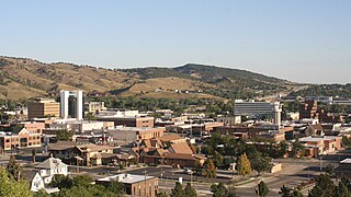
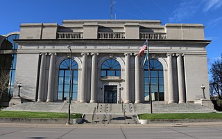
Rapid City is the second most populous city in South Dakota after Sioux Falls and the county seat of Pennington County. Named after Rapid Creek, where the settlement developed, it is in western South Dakota, on the Black Hills' eastern slope. The population was 74,703 as of the 2020 Census.

<span class="mw-page-title-main">Rapid Valley, South Dakota</span> CDP in South Dakota, United States

Rapid Valley is a census-designated place (CDP) and unincorporated community in Pennington County, South Dakota, United States, and a suburb of Rapid City. The population was 8,098 at the 2020 census. Rapid Valley has been a retreat for people living in Rapid City due to its low crime, cheap land, and views of the Black Hills. Rapid Valley is home to many industrial and financial businesses, and is the headquarters for many corporations specializing in transport and engineering.

<span class="mw-page-title-main">Elk Point, South Dakota</span> City in South Dakota, United States

Elk Point is a city in and county seat of Union County, South Dakota, United States. The population was 2,149 as of the 2020 census.

<span class="mw-page-title-main">Black Elk Peak</span> Highest point in South Dakota

Black Elk Peak is the highest natural point in the U.S. state of South Dakota and the Midwestern United States. It lies in the Black Elk Wilderness area, in southern Pennington County, in the Black Hills National Forest. The peak lies 3.7 mi (6.0 km) west-southwest of Mount Rushmore. At 7,244 feet (2,208 m), it is the highest summit in the United States east of the Rocky Mountains. Though part of the North American Cordillera, it is generally considered to be geologically separate from the Rocky Mountains.

<span class="mw-page-title-main">Summerset, South Dakota</span> City in South Dakota, United States

Summerset is a city in Meade County, South Dakota, United States. The population was 2,972 at the 2020 census. Located in the western part of the state, it is the first city to incorporate in the state since 1985.

<span class="mw-page-title-main">Geography of South Dakota</span> Overview of the geography of South Dakota

South Dakota is a state located in the north-central United States. It is usually considered to be in the Midwestern region of the country. The state can generally be divided into three geographic regions: eastern South Dakota, western South Dakota, and the Black Hills. Eastern South Dakota is lower in elevation and higher in precipitation than the western part of the state, and the Black Hills are a low, isolated mountain group in the southwestern corner of the state. Smaller sub-regions in the state include the Coteau des Prairies, Missouri Coteau, James River Valley, and the Dissected Till Plains. Geologic formations in South Dakota range in age from two billion-year-old Precambrian granite in the Black Hills to glacial till deposited over the last few million years. South Dakota is the 17th-largest state in the country.

<span class="mw-page-title-main">Rapid City, South Dakota metropolitan area</span>

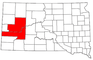
The Rapid City-Spearfish, SD combined statistical area, as defined by the United States Census Bureau, consists of the Rapid City, SD metropolitan statistical area and Spearfish, SD micropolitan statistical area. Anchored by the city of Rapid City, the area corresponds to the entirety of Pennington, Meade, and Lawrence counties in the state of South Dakota. As of the 2020 census, the CSA had a population of 164,842.

References

  1. "ArcGIS REST Services Directory". United States Census Bureau. Retrieved October 15, 2022.
  2. 1 2 U.S. Geological Survey Geographic Names Information System: Piedmont, South Dakota
  3. 1 2 "Census Population API". United States Census Bureau. Retrieved October 15, 2022.
  4. "Piedmont, South Dakota". Geographic Names Information System . United States Geological Survey, United States Department of the Interior.
  5. "U.S. Census Bureau: Piedmont city, South Dakota". www.census.gov. United States Census Bureau. Retrieved February 26, 2022.
  6. Zip Code Lookup
  7. Federal Writers' Project (1940). South Dakota Place-Names, Part I: State, County, and Town Names. Vermillion, South Dakota: University of South Dakota. OCLC   34885177.
  8. 1 2 3 Miller, Steve (November 5, 2007). "Piedmont elects first town board". Rapid City Journal . Retrieved July 13, 2010.
  9. "Geographic Change Notes for South Dakota" (TXT). United States Census Bureau . Retrieved June 17, 2010.
  10. "Red Valley". Geographic Names Information System . United States Geological Survey, United States Department of the Interior.
  11. "Black Hills National Forest - Environment". gorp.com. Archived from the original on November 28, 2010. Retrieved July 27, 2010.
  12. "US Gazetteer files 2010". United States Census Bureau. Archived from the original on February 20, 2011. Retrieved June 21, 2012.
  13. "Climate Statistics for Piedmont, SD" . Retrieved September 28, 2013.
  14. United States Census Bureau. "Census of Population and Housing" . Retrieved June 2, 2014.
  15. "Population Estimates". United States Census Bureau . Retrieved May 30, 2019.
  16. "U.S. Census website". United States Census Bureau . Retrieved June 21, 2012.
  17. 1 2 Miller, Steve (August 19, 2007). "Piedmont residents cleaning up debris". Rapid City Journal . Retrieved July 13, 2010.
  18. Journal Staff (July 16, 2005). "Ricco Fire almost contained". Rapid City Journal . Retrieved July 13, 2010.
  19. Wolfgang, Justin (August 17, 2007). "Pummeled by storm, Piedmont begins arduous clean up". Rapid City Journal . Retrieved July 13, 2010.