Cheyenne River Indian Reservation

Last updated
Cheyenne River Indian Reservation
Cheyenne River IR.jpg
Farmland on the reservation
0605R Cheyenne River Reservation Locator Map.svg
Location in South Dakota
Coordinates: 45°04′35″N101°13′33″W / 45.07639°N 101.22583°W / 45.07639; -101.22583
Tribe Cheyenne River Sioux Tribe
Country United States
State South Dakota
Counties Dewey
Haakon
Meade
Stanley
Ziebach
Established1889
Government
  Governing bodyGeneral Tribal Council
Area
  Total11,051.447 km2 (4,266.987 sq mi)
Population
 (2010) [1]
  Total8,090
Time zone UTC-7 (MST)
  Summer (DST) UTC-6 (MDT)
GDP$154.8 Million (2018)
Website cheyenneriversioux.com

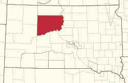
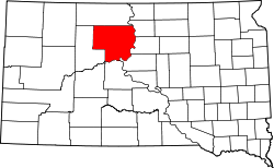
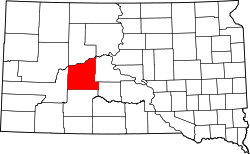
The Cheyenne River Indian Reservation was created by the United States in 1889 by breaking up the Great Sioux Reservation, following the attrition of the Lakota in a series of wars in the 1870s. The reservation covers almost all of Dewey and Ziebach counties in South Dakota. In addition, many small parcels of off-reservation trust land are located in Stanley, Haakon, and Meade counties.

Contents

The total land area is 4,266.987 sq mi (11,051.447 km2), making it the fourth-largest Indian reservation in land area in the United States. Its largest community is unincorporated North Eagle Butte, while adjacent Eagle Butte is its largest incorporated city.

Land status

The original Cheyenne River Reservation covered over 5,000 sq. mi. The reservation has subsequently decreased in size; today it is 4,266.987 sq mi (11,051.447 km2). The original northern boundary was the Grand River. However, in the early 20th century, land south of the Grand River was ceded to the Standing Rock Reservation.

The land was opened up to non-Native settlement in 1909. When the Land Acts took effect, the northern part of the Cheyenne River Reservation was lost. However, the southern section of the Cheyenne River Reservation still remains. It covers 1,514,652 acres or 2,366 sq. mi.

A small number of White River Utes were resettled on the reservation in 1906 and 1907, being allocated 4 townships totaling 92,160 acres. [2] That land remains in the former northern part of the Cheyenne River Reservation. Their communities are Iron Lightning and Thunder Butte.

Four Bear Creek, a tributary of the Missouri River, is located in the Cheyenne River Reservation. [3]

History

Map of the reservation from 1900 Northern Pacific Railway map circa 1900 Cheyenne River Indian Reservation.png
Map of the reservation from 1900
Woman drying food on an outdoor rack in the 1930s Photograph of Food Drying Outdoors - NARA - 285276.jpg
Woman drying food on an outdoor rack in the 1930s

The Treaty of Fort Laramie of 1868 created the Great Sioux Reservation, a single reservation covering parts of six states, including both of the Dakotas. Subsequent treaties in the 1870s and 1880s broke this reservation up into several smaller reservations. The Cheyenne River Indian Reservation was created in 1889. [4]

Chief Sitting Bull lived north of the Cheyenne River Reservation on the Grand River, which is the Standing Rock Reservation. In 1890, the United States became very concerned about Chief Sitting Bull who they feared was going to lead an exodus off the Reservation.

Several hundred Lakota gathered on the Grand River on the Standing Rock Reservation in December 1890, preparing to flee the reservation. A force of 39 Indian policemen and four volunteers were sent to chief Sitting Bull's residence near the Grand River on December 16, 1890, to arrest him.

Initially, Sitting Bull cooperated but became angry once led out of his residence and noticed around 50 of his soldiers were there to support him. During some point while outside of chief Sitting Bull's residence, a battle commenced in which the legendary leader was killed. A total of 18 casualties occurred in the battle. Among the killed were Sitting Bull and his son.

Sitting Bull's half brother, Spotted Elk, led an exodus of 350 people off the Standing Rock Reservation to the south onto the Cheyenne River Reservation. They were captured on December 28, 1890, on the Pine Ridge Reservation, about 30 miles to the east of the settlement of Pine Ridge. Next day they were attacked by over 500 US Army soldiers, and event known as the Wounded Knee Massacre. Approximately 250 to 300 Natives were killed, including many women and children, and the massacre halted the exodus. [5] Survivors settled on the Pine Ridge Reservation or returned to the Cheyenne River Reservation.

Since then, the Cheyenne River Reservation's northern border has changed. It is no longer the Grand River. The 60th United States Congress authorized the sale of unallotted land on the reservation in 1908, and in 1909 William Howard Taft issued a presidential proclamation which opened up the Cheyenne River Reservation to white settlement. [6] :13 However, the present day settlements located along the Grand River are predominantly Algonquian.[ citation needed ]

Beginning in 1948, the US government dammed the Missouri River for electrical power and flood control. The dam project submerged 8% of reservation land. [4]

On August 15, 2018, at 9:06 a.m. MDT, the tribe signed KIPI on the air. The station will serve as an educational and economic opportunity for residents of the reservation.

Tribal Flag

This is the tribal flag of the Cheyenne River Sioux Tribe. Flag of the Cheyenne River Sioux Tribe.PNG
This is the tribal flag of the Cheyenne River Sioux Tribe.

"The blue represents the thunderclouds above the world where the thunderbirds who control the four winds live. The rainbow is for the Cheyenne River Sioux people who are keepers of the most Sacred Calf Pipe, a gift from the White Buffalo Calf Maiden. The eagle feathers at the edges at the rim of the world represent the spotted eagle who is the protector of all Lakota. The two pipes fused together are for unity. One pipe is for the Lakota, the other for all the other Indian Nations. The Yellow hoops represent the Sacred Hoop, which shall not be broken. The Sacred Calf Pipe bundle in red represents Wakan Tanka – The Great Mystery. All the colors of the Lakota are visible. The red, yellow, black, and white represent the four major races. The blue is for heaven and the green for Mother Earth." [7]

Current conditions

Tribal flags at Eagle Butte Tribal Flags at Eagle Butte, SD.JPG
Tribal flags at Eagle Butte

The CRIR is the home of the federally recognized Cheyenne River Sioux Tribe (CRST) or Cheyenne River Lakota Nation (Lakota : Wakpá Wašté Lakȟóta Oyáte). The members include representatives from four of the traditional seven bands of the Lakota, also known as Teton Sioux: the Minnecoujou, Two Kettle (Oohenunpa), Sans Arc (Itazipco) and Blackfoot (Sihásapa).

The CRIR is bordered on the north by the Standing Rock Indian Reservation, on the west by Meade and Perkins Counties; on the south by the Cheyenne River; and on the east by the Missouri River in Lake Oahe. Much of the land inside the boundaries is privately owned. The CRST headquarters and BIA agency are located at Eagle Butte, South Dakota. The reservation is reached via US-212.

The 2010 census reported a population of 8,090 persons. [1] Many of the 13 small communities on the Cheyenne River Reservation do not have water systems, making it difficult for people to live in sanitary conditions. In recent years, water systems have been constructed that tap the Missouri Main Stem reservoirs, such as Lake Oahe, which forms the eastern edge of the Reservation.

With few jobs available on the reservation or in nearby towns, many tribal members are unemployed. Two-thirds of the population survives on much less than one-third of the American average income. Such dismal living conditions have contributed to feelings of hopelessness and despair among the youth. Indian Country Today reports than one in five girls on the Cheyenne River Reservation has contemplated suicide and more than one in ten has attempted it. As of 2009, a modern medical center was under construction in Eagle Butte to replace an outdated facility. [8]

Beginning on January 22, 2010, a blizzard and ice storm swept across the reservation, downing as many as 3,000 power lines and leaving thousands of residents without power, heat or water. Response to the disaster was slow. Although the state government declared a state of emergency, the situation did not initially receive much attention in the media or from legislators. Power was finally restored to most residents as of February 12, 2010, but overall conditions were still grim.

On February 14, 2010, the TV commentator Keith Olbermann highlighted the situation on his program Countdown with Keith Olbermann . Within 48 hours more than $250,000 in donations was raised for the reservation. As of February 24, 2010, more than $400,000 in donations had been raised. No deaths had been reported as a result of the disaster. Several elderly residents dependent on dialysis treatment were evacuated to nearby towns. As of February 26, 2010, tribal representatives turned attention to raising awareness about the reservation's damaged water infrastructure. [9] [10] [11]

Communities

Remains of a native American soldier, who died during the Korean War, are honored at a funeral in Eagle Butte before reburial in South Dakota in 2009. US Army 52068 Korean War vet gets native-American honors.jpg
Remains of a native American soldier, who died during the Korean War, are honored at a funeral in Eagle Butte before reburial in South Dakota in 2009.

The communities of Iron Lightning, Thunder Butte, Bullhead, Little Eagle, and Wakpala date back to the original 1889 reservation boundaries. Nearly all communities on the Cheyenne River Reservation, including in the land area settled by white homesteaders after 1908, have a majority population of Native Americans. Most of the communities rank as the lowest income per-capita in the United States. However, Eagle Butte and North Eagle Butte are more economically diverse, and the main business district of Eagle Butte is similar to that of many communities with comparable populations.

Education

Cheyenne-Eagle Butte School, which is jointly operated by the Bureau of Indian Education (BIE) and the Eagle Butte School District 20–1, is on the reservation. [12]

Notable tribal members

Attractions

Timber Lake and Area MuseumItems from the Cheyenne River Sioux Tribe and Standing Rock Sioux Tribe are at the museum. A collection of marine fossils, native to South Dakota, are also on display. Visitors can purchase locally-made goods. [13]
H.V. Johnston Lakota Cultural CenterThe museum is home to a collection of artifacts from the Cheyenne River Sioux Tribe, including murals, photographs, beadwork, and paintings. Visitors can also purchase locally-made goods. [13]
Native American Scenic BywayA 450-mile-long byway that leads from the Nebraska border to the North Dakota border. It goes through 5 reservations and tribal lands. [13]
International Society for the Protection of Mustangs and Burros (ISPMB)A Native non-profit organization whose mission is to save America's wild horses and burros. The attraction allows visitors to take a tour through the herds of horses. [13]

See also

Related Research Articles

<span class="mw-page-title-main">Lakota people</span> Indigenous people of the Great Plains

The Lakota are a Native American people. Also known as the Teton Sioux, they are one of the three prominent subcultures of the Sioux people, with the Eastern Dakota (Santee) and Western Dakota (Wičhíyena). Their current lands are in North and South Dakota. They speak Lakȟótiyapi—the Lakota language, the westernmost of three closely related languages that belong to the Siouan language family.

<span class="mw-page-title-main">Sioux</span> Native American and First Nations ethnic groups

The Sioux or Oceti Sakowin are groups of Native American tribes and First Nations people from the Great Plains of North America. The Sioux have two major linguistic divisions: the Dakota and Lakota peoples. Collectively, they are the Očhéthi Šakówiŋ, or "Seven Council Fires". The term "Sioux", an exonym from a French transcription ("Nadouessioux") of the Ojibwe term "Nadowessi", can refer to any ethnic group within the Great Sioux Nation or to any of the nation's many language dialects.

<span class="mw-page-title-main">Fort Yates, North Dakota</span> City in Standing Rock Indian Reservation, United States

Fort Yates is a city in Sioux County, North Dakota, United States. It is the tribal headquarters of the Standing Rock Sioux Tribe and county seat of Sioux County. Since 1970 the population has declined markedly from more than 1,100 residents, as people have left for other locations for work. The population was 176 at the 2020 census.

<span class="mw-page-title-main">Sitting Bull</span> Hunkpapa Lakota leader (1831–1890)

Sitting Bull was a Hunkpapa Lakota leader who led his people during years of resistance against United States government policies. Sitting Bull was killed by Indian agency police on the Standing Rock Indian Reservation during an attempt to arrest him at a time when authorities feared that he would join the Ghost Dance movement.

<span class="mw-page-title-main">Pine Ridge Indian Reservation</span> Indian reservation in United States, Oglala Sioux

The Pine Ridge Indian Reservation, also called Pine Ridge Agency, is an Oglala Lakota Indian reservation located in the U.S. state of South Dakota, with a small portion of it extending into Nebraska. Originally included within the territory of the Great Sioux Reservation, Pine Ridge was created by the Act of March 2, 1889, 25 Stat. 888. in the southwest corner of South Dakota on the Nebraska border. It consists of 3,468.85 sq mi (8,984 km2) of land area and is one of the largest reservations in the United States.

<span class="mw-page-title-main">Grand River (South Dakota)</span> Stream in South Dakota, USA


The Grand River is a tributary of the Missouri River in South Dakota in the United States. The length of the combined branch is 110 mi (177 km). With its longest fork, its length is approximately 200 mi (320 km).

<span class="mw-page-title-main">Oahe Dam</span> Dam in Hughes/Stanley counties, South Dakota

The Oahe Dam is a large earthen dam on the Missouri River, just north of Pierre, South Dakota, United States. The dam creates Lake Oahe, the fourth-largest man-made reservoir in the United States. The reservoir stretches 231 miles (372 km) up the course of the Missouri to Bismarck, North Dakota. The dam's power plant provides electricity for much of the north-central United States. It is named for the Oahe Indian Mission established among the Lakota Sioux in 1874.

<span class="mw-page-title-main">Lake Oahe</span> Reservoir in North Dakota, United States

Lake Oahe is a large reservoir behind Oahe Dam on the Missouri River; it begins in central South Dakota and continues north into North Dakota in the United States. The lake has an area of 370,000 acres (1,500 km2) and a maximum depth of 205 ft (62 m). By volume, it is the fourth-largest reservoir in the US. Lake Oahe has a length of approximately 231 mi (372 km) and has a shoreline of 2,250 mi (3,620 km). 51 recreation areas are located along Lake Oahe, and 1.5 million people visit the reservoir every year. The lake is named for the 1874 Oahe Indian Mission.

<span class="mw-page-title-main">Gall (Native American leader)</span> 19th century Lakota chief

Gall, Lakota Phizí, was an important military leader of the Hunkpapa Lakota in the Battle of the Little Bighorn. He spent four years in exile in Canada with Sitting Bull's people, after the wars ended and surrendered in 1881 to live on the Standing Rock Reservation. He would eventually advocate for the assimilation of his people to reservation life and served as a tribal judge in his later years.

<span class="mw-page-title-main">Sitting Bull College</span> Public tribal college in Fort Yates, North Dakota, U.S.

Sitting Bull College (SBC) is a public tribal land-grant college in Fort Yates, North Dakota. It was founded in 1973 by the Standing Rock Sioux tribe of the Standing Rock Indian Reservation in south-central North Dakota. The SBC campuses are located in Fort Yates, North Dakota and McLaughlin, South Dakota. It serves as the primary educational institution on the Standing Rock Reservation.

<span class="mw-page-title-main">Standing Rock Indian Reservation</span> Native American reservation in the United States

The Standing Rock Reservation lies across the border between North and South Dakota in the United States, and is inhabited by ethnic "Hunkpapa and Sihasapa bands of Lakota Oyate and the Ihunktuwona and Pabaksa bands of the Dakota Oyate," as well as the Hunkpatina Dakota. The Ihanktonwana Dakota are the Upper Yanktonai, part of the collective of Wiciyena. The sixth-largest Native American reservation in land area in the US, Standing Rock includes all of Sioux County, North Dakota, and all of Corson County, South Dakota, plus slivers of northern Dewey and Ziebach counties in South Dakota, along their northern county lines at Highway 20.

<span class="mw-page-title-main">Hunkpapa</span> Traditional tribal grouping within the Lakota people

The Hunkpapa are a Native American group, one of the seven council fires of the Lakota tribe. The name Húŋkpapȟa is a Lakota word, meaning "Head of the Circle". By tradition, the Húŋkpapȟa set up their lodges at the entryway to the circle of the Great Council when the Sioux met in convocation. They speak Lakȟóta, one of the three dialects of the Sioux language.

<span class="mw-page-title-main">Great Sioux Reservation</span> Former Indian reservation in the United States

The Great Sioux Reservation initially set aside land west of the Missouri River in South Dakota and Nebraska for the use of the Sioux, who had dominated this territory. The reservation was established in the Fort Laramie Treaty of 1868. It included all of present-day western South Dakota and modern Boyd County, Nebraska. This area was established by the United States as a reservation for the Teton Sioux, also known as the Lakota: the seven western bands of the "Seven Council Fires".

<span class="mw-page-title-main">Rosebud Indian Reservation</span> Indian reservation in South Dakota, United States

The Rosebud Indian Reservation is an Indian reservation in South Dakota, United States. It is the home of the federally recognized Rosebud Sioux Tribe, who are Sicangu, a band of Lakota people. The Lakota name Sicangu Oyate translates as the "Burnt Thigh Nation", also known by the French term, the Brulé Sioux.

<span class="mw-page-title-main">Thunder Butte</span> Geographic feature in South Dakota, United States

Thunder Butte is a prominent butte landmark located in the northwest corner of Ziebach County, South Dakota, in the United States. Thunder Butte is a large, isolated hill that can be seen for many miles in every direction, and has served throughout history as an important orientation point for area residents or a navigational aide for travelers crossing the surrounding plains. The butte gives its name to a small community at its base, and to a small creek that runs into the Moreau River.

David Archambault II is the former (2013–2017) tribal chairman of the Standing Rock Indian Reservation in North Dakota. He was instrumental in the Dakota Access Pipeline protests and continues to work to promote an understanding of the historical treaty rights and indigenous rights of Native American people. Archambault holds degrees in Business Administration and Management. In 2017 he joined FirstNation HealthCare as its chief consulting officer.

<span class="mw-page-title-main">LaDonna Brave Bull Allard</span> Lakota historian and activist (1956–2021)

LaDonna Brave Bull Allard, known as Tamakawastewin, was a Native American Dakota and Lakota historian, genealogist, and a matriarch of the water protector movement.

<span class="mw-page-title-main">Eagle Woman</span> American peace activist (1820–1888)

Eagle Woman That All Look At was a Lakota activist, diplomat, trader, and translator, who was known for her efforts mediating the conflicts between white settlers, the United States government, and the Sioux. She is credited with being the only woman recognized as a chief among the Sioux.

Avis Red Bear is an American journalist and the founder of the Teton Times, an independent Native American newspaper. She is a member of the Standing Rock Sioux Tribe.

<span class="mw-page-title-main">Harold Frazier</span> American politician and tribal leader

Harold C. Frazier is an American politician and tribal leader who is the former Chairman of the Cheyenne River Sioux Tribe, serving in that position since 2014. A member of the Democratic Party, Frazier serves concurrently as the Chairman of the Great Plains Tribal Chairmen’s Association, a position he was elected to in 2018.

References

  1. 1 2 "2010 Census Summary File 1: Cheyenne River Reservation and Off-Reservation Trust Land, SD". American FactFinder. United States Census Bureau. Archived from the original on 13 February 2020. Retrieved 29 June 2018.
  2. Laudenschlager, David D. (Summer 1979). "The Utes in South Dakota, 1906-1908" (PDF). South Dakota History. 9 (3): 233–247. ISSN   0361-8676 . Retrieved 29 June 2018.
  3. Sportsman's Connection (2016). South Dakota Fishing Maps Guide Book. Superior, Wisconsin: Billing, Jim. p. 204. ISBN   978-1-885010-61-2.
  4. 1 2 "South Dakota: Cheyenne River Reservation". nativepartnership.org. Addison, TX: Partnership With Native Americans. Archived from the original on 29 July 2017. Retrieved 29 June 2018.
  5. Nelson A. Miles to the Commissioner of Indian Affairs, March 13, 1917, "The official reports make the number killed 90 warriors and approximately 200 women and children."
  6. Hoxie, Frederick E. (Winter 1979). "From Prison to Homeland: The Cheyenne River Indian Reservation before WWI" (PDF). South Dakota History. 10 (1): 1–24. ISSN   0361-8676 . Retrieved 29 June 2018.
  7. "History | Cheyenne River Sioux Tribe | Eagle Butte". CRST App. Retrieved 2024-04-12.
  8. "A Rising but Doubted Dream on a Reservation", Dan Barry, The New York Times , 12 July 2009
  9. "Keith Olbermann Helps Raise $250,000 for Storm-Ravaged Cheyenne River Reservation", John R. Platt, Archived February 24, 2010, at the Wayback Machine , Tonic, 15 February 2010
  10. "Help for Storm-Battered Sioux Tribe", MSNBC , 24 February 2010
  11. "Many on South Dakota Reservation Remain Without Power After Storm", The New York Times , 31 January 2010
  12. "About". Eagle Butte School District 20-1. Retrieved 2021-08-06.
  13. 1 2 3 4 "Cheyenne River Sioux Tribe". Travel South Dakota. Retrieved 2024-04-12.

Commons-logo.svg Media related to Cheyenne River Indian Reservation at Wikimedia Commons