Renner Corner, South Dakota | |
|---|---|
 Renner Corner, South Dakota  Renner Corner, South Dakota | |
| Coordinates: 43°39′09″N96°42′16″W / 43.65250°N 96.70444°W | |
| Country | United States |
| State | South Dakota |
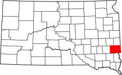
| County | Minnehaha |
| Area | |
• Total | 1.29 sq mi (3.34 km2) |
| • Land | 1.29 sq mi (3.33 km2) |
| • Water | 0.0039 sq mi (0.01 km2) |
| Elevation | 1,483 ft (452 m) |
| Population | |
• Total | 347 |
| • Density | 269.7/sq mi (104.13/km2) |
| Time zone | UTC-6 (Central (CST)) |
| • Summer (DST) | UTC-5 (CDT) |
| Area code | 605 |
| GNIS feature ID | 2584567 [2] |
Renner Corner is an unincorporated community and census-designated place in Minnehaha County, South Dakota, United States. Its population was 347 as of the 2020 census. [4] The community is located along South Dakota Highway 115, north of Sioux Falls.