Booge, South Dakota

Last updated

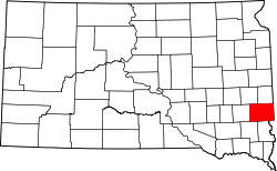
Booge is an unincorporated community in Red Rock Township, Minnehaha County, South Dakota, United States. The community sits on a major route of the Burlington Northern and Santa Fe Railway, and it is a half-way point between Garretson, South Dakota and Manley, Minnesota.

Contents

Geography

Booge is located at 43°38′45″N96°27′36″W / 43.645806°N 96.460041°W / 43.645806; -96.460041 . [1] Booge sits 2+12 miles (4.0 km) north of Interstate 90 on the Minnesota border on County Road 130 (CR 130) and one mile (1.6 km) west of Minnesota State Highway 23.

History

Booge was named after C. A. Booge, an official of the Sioux City and Northern Railroad Company on January 21, 1891. Booge was responsible for getting the railroad line extended into South Dakota.

Related Research Articles

<span class="mw-page-title-main">Minnehaha County, South Dakota</span> County in South Dakota, United States

Minnehaha County is a county on the eastern border of the state of South Dakota. As of the 2020 census, the population was 197,214, making it the state's most populous county. It contains over 20% of the state's population. Its county seat is Sioux Falls, South Dakota's most populous city. The county was created in 1862 and organized in 1868. Its name was derived from the Sioux word Mnihaha, meaning "rapid water," or "waterfall".

<span class="mw-page-title-main">Rock County, Minnesota</span> County in Minnesota, United States

Rock County is a county located in the southwestern corner of the U.S. state of Minnesota. According to the 2020 census, its population was 9,704. The county seat is Luverne.

<span class="mw-page-title-main">Kittson County, Minnesota</span> County in Minnesota, United States

Kittson County is a county in the northwestern corner of the U.S. state of Minnesota along the Canada–US border, south of the Canadian province of Manitoba. As of the 2020 census, the population was 4,207. Its county seat is Hallock.

<span class="mw-page-title-main">Hokah, Minnesota</span> City in Minnesota, United States

Hokah is a city in Houston County, Minnesota, United States. The population was 580 at the 2010 census. Hokah is located near the confluence of the Root and Mississippi rivers, opposite La Crosse, Wisconsin, and is part of the La Crosse metropolitan area.

<span class="mw-page-title-main">Crookston, Minnesota</span> City in Minnesota, United States

Crookston is a city in the U.S. state of Minnesota. It is the county seat of Polk County. The population was 7,482 at the 2020 census. It is part of the "Grand Forks, ND-MN Metropolitan Statistical Area" or "Greater Grand Forks".

<span class="mw-page-title-main">Erskine, Minnesota</span> City in Minnesota, United States

Erskine is a city in Polk County, Minnesota. The population was 403 at the time of the 2020 census. It is part of the Greater Grand Forks region.

<span class="mw-page-title-main">North Spearfish, South Dakota</span> Census-designated place in South Dakota, United States

North Spearfish is a census-designated place (CDP) in Lawrence County, South Dakota, United States. The population was 2,366 at the 2020 census.

<span class="mw-page-title-main">Mabank, Texas</span> Town in Texas, United States

Mabank is a town in Henderson, Van Zandt and Kaufman counties in the U.S. state of Texas. Its population was 4,050 at the 2020 census.

<span class="mw-page-title-main">Coteau des Prairies</span> Highland plateau in the north-central United States

The Coteau des Prairies is a plateau approximately 200 miles in length and 100 miles in width, rising from the prairie flatlands in eastern South Dakota, southwestern Minnesota, and northwestern Iowa in the United States. The southeast portion of the Coteau comprises one of the distinct regions of Minnesota, known as Buffalo Ridge.

<span class="mw-page-title-main">Rowena, South Dakota</span> Unincorporated community in South Dakota, U.S.

Rowena is an unincorporated community and a census-designated place (CDP) in Minnehaha County, South Dakota, United States. The population of the CDP was 68 at the 2020 census. It is located along South Dakota Highway 42.

<span class="mw-page-title-main">Sheyenne River</span>

The Sheyenne River is one of the major tributaries of the Red River of the North, meandering 591 miles (951 km) across eastern North Dakota, United States.

<span class="mw-page-title-main">Northern Plains Railroad</span>

The Northern Plains Railroad is a short line railroad that operates over 344 miles (554 km) of track in the northern U.S. state of Minnesota and the northern U.S. state of North Dakota.

<span class="mw-page-title-main">Buffalo Ridge</span> Range of hills in Minnesota, US

Buffalo Ridge is a large expanse of rolling hills in the southeastern part of the larger Coteau des Prairies. It stands 1,995 feet (608 m) above sea level. The Buffalo Ridge is sixty miles (97 km) long and runs through Lincoln, Pipestone, Murray, Nobles, and Rock counties in the southwest corner of Minnesota.

<span class="mw-page-title-main">Traverse Gap</span> River channel in Minnesota, US

The Traverse Gap is an ancient river channel occupied by Lake Traverse, Big Stone Lake and the valley connecting them at Browns Valley, Minnesota. It is located on the border of the U.S. states of Minnesota and South Dakota. Traverse Gap has an unusual distinction for a valley: it is crossed by a continental divide, and in some floods water has flowed across that divide from one drainage basin to the other. Before the Anglo-American Convention of 1818 it marked the border between British territory in the north and U.S. – or earlier, French – territory in the south.

Benclare is an unincorporated community in the extreme southeastern corner of Minnehaha County, South Dakota, United States.

<span class="mw-page-title-main">Bruce, Minnesota</span> Ghost town in Rock County, Minnesota, US

Bruce was the name of a town in Rock County, Minnesota, USA. The town has been completely abandoned, and no trace of it remains.

Ellis is an unincorporated community in south-central Minnehaha County, South Dakota, United States. Ellis is located approximately one mile west of the Sioux Falls city limits on Ellis Road, or 1.5 miles (2.4 km) north of South Dakota Highway 42. The Ellis & Eastern Railroad is based in Ellis, running 14.5 miles (23.3 km) to Brandon to the east. In 1995, the two largest commodities carried by trains were non-metallic minerals and chemicals, mostly for factories near Sioux Falls. The community is considered a part of the Sioux Falls metropolitan area.

<span class="mw-page-title-main">Verendrye, North Dakota</span> Ghost town in North Dakota, U.S.

Verendrye was a historic unincorporated community in McHenry County, North Dakota, United States, located approximately eight miles (13 km) northwest of Karlsruhe and 13 miles (21 km) northeast of Velva within Falsen Township. Although classified by the USGS as a populated place, it is considered a ghost town.

Morefield is an unincorporated community in central Minnehaha County in Sverdrup Township, South Dakota, United States. Morefield is 2 miles (3 km) northeast of Crooks, along an abandoned Chicago, Milwaukee, St. Paul and Pacific rail line that ran from Renner to Madison. It is also 3 miles (5 km) north of the Renner/Crooks exit on Interstate 29 on County road 133.

The Dakota Rail Trail runs 28.1 miles (42.6 km) from Wayzata to Lester Prairie, Minnesota. It is on part of the former track bed of the Hutchinson Spur of the Great Northern Railway. The railway line helped bring wheat and raw materials from Central Minnesota to the flour mills, factories and warehouses in Minneapolis from 1885 until 2001. The railway line, from which there are views of the countryside, was also designed to bring tourists to the communities on Lake Minnetonka in the late 1880s.

References

  1. "US Gazetteer files: 2010, 2000, and 1990". United States Census Bureau. February 12, 2011. Retrieved April 23, 2011.