Edison Township, South Dakota | |
|---|---|
 Edison Township | |
| Coordinates: 43°43′03″N96°35′29″W / 43.71750°N 96.59139°W | |
| Country | |
| State | |
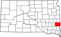
| Counties | Minnehaha |
| Area | |
• Total | 36.14 sq mi (93.59 km2) |
| • Land | 36.04 sq mi (93.35 km2) |
| • Water | 0.093 sq mi (0.24 km2) |
| Elevation | 1,470 ft (450 m) |
| Population (2020) | |
• Total | 545 |
| • Density | 15.1/sq mi (5.84/km2) |
| Time zone | UTC-6 (Central (CST)) |
| • Summer (DST) | UTC-5 (CDT) |
| Area code | 605 |
| FIPS code | 46-18380 |
| GNIS feature ID | 1267938 [1] |
Edison Township is a township in Minnehaha County, South Dakota, United States. The population was 545 at the 2020 census. [2]