Colton, South Dakota

Last updated

Colton, South Dakota
Colton South Dakota.jpg
South Main Avenue in Colton
Minnehaha County South Dakota Incorporated and Unincorporated areas Colton Highlighted.svg
Location in Minnehaha County and the state of South Dakota
Coordinates: 43°47′13″N96°55′41″W / 43.78694°N 96.92806°W / 43.78694; -96.92806
Country United States
State South Dakota
County Minnehaha
Incorporated1904 [1]
Government
  MayorTrevor Bunde
Area
[2]
  Total0.70 sq mi (1.82 km2)
  Land0.70 sq mi (1.82 km2)
  Water0.00 sq mi (0.00 km2)
Elevation
[3]
1,604 ft (489 m)
Population
 (2020) [4]
  Total738
  Density1,052.78/sq mi (406.34/km2)
Time zone UTC-6 (Central (CST))
  Summer (DST) UTC-5 (CDT)
ZIP code
57018
Area code 605
FIPS code 46-13380
GNIS feature ID1267334 [3]
Website coltonsd.govoffice3.com

Colton is a city in Minnehaha County, South Dakota, United States. The population was 738 at the 2020 census. [5]

Contents

Colton has the name of J. E. Colton, a railroad official. [6]

History

Creation

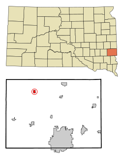
The town started with a creamery in 1897, made by J. E. Colton. Other businesses started to form around the creamery, making a Main Street. In 1901, the founder started a newspaper called "The Colton Courier" that stayed in place for years. The three other shareowners were W. O. Colton and Dave Crooks, the founder of Colton's Neighboring town, Crooks. Between 1905 and 1906 a railroad was built through Colton, which used to have passenger service. J. E. Colton was 53 years old when he died in 1910.

Schools

The first Colton school was made in 1879 by the town's founder, J. E. Colton, and was a one-room schoolhouse. From 1903 to 1905 a new, larger schoolhouse was built in place of the old one and began to teach high school subjects. In 1907 a high school was built that was meant to put students through for two years each. It met that goal, but lasted no more than two years, being put out of use in 1909. 1913 started a new four-year high school with six teachers that lasted much longer. Near the end of 1924, a new school was built out of brick. It used the same standard system as the previous school. The school stopped being used in 1967 when the school of Tri-Valley was constructed, which combined the students of several small towns.

Geography

According to the United States Census Bureau, the city has a total area of 0.70 square miles (1.81 km2), all land. [7]

Demographics

Historical population
CensusPop.Note
1910 407
1920 60849.4%
1930 575−5.4%
1940 6157.0%
1950 521−15.3%
1960 59313.8%
1970 6011.3%
1980 75726.0%
1990 657−13.2%
2000 6620.8%
2010 6873.8%
2020 7387.4%
U.S. Decennial Census [8] [4]

2010 census

As of the census [9] of 2010, there were 687 people, 302 households, and 184 families residing in the city. The population density was 981.4 inhabitants per square mile (378.9/km2). There were 320 housing units at an average density of 457.1 per square mile (176.5/km2). The racial makeup of the city was 98.4% White, 0.1% African American, 0.7% Native American, and 0.7% from two or more races. Hispanic or Latino of any race were 0.7% of the population.

There were 302 households, of which 30.8% had children under the age of 18 living with them, 47.0% were married couples living together, 7.9% had a female householder with no husband present, 6.0% had a male householder with no wife present, and 39.1% were non-families. 34.8% of all households were made up of individuals, and 16.5% had someone living alone who was 65 years of age or older. The average household size was 2.27 and the average family size was 2.92.

The median age in the city was 36.1 years. 26.2% of residents were under the age of 18; 5.7% were between the ages of 18 and 24; 29.2% were from 25 to 44; 23.2% were from 45 to 64; and 15.9% were 65 years of age or older. The gender makeup of the city was 48.6% male and 51.4% female.

2000 census

As of the census of 2000, there were 662 people, 266 households, and 184 families residing in the city. The population density was 948.1 inhabitants per square mile (366.1/km2). There were 285 housing units at an average density of 408.2 per square mile (157.6/km2). The racial makeup of the city was 99.09% White, 0.30% Native American, 0.15% Pacific Islander, 0.30% from other races, and 0.15% from two or more races. Hispanic or Latino of any race were 1.21% of the population.

There were 266 households, out of which 32.7% had children under the age of 18 living with them, 57.9% were married couples living together, 9.0% had a female householder with no husband present, and 30.5% were non-families. 27.4% of all households were made up of individuals, and 13.2% had someone living alone who was 65 years of age or older. The average household size was 2.43 and the average family size was 2.95.

In the city, the population was spread out, with 24.5% under the age of 18, 8.8% from 18 to 24, 27.3% from 25 to 44, 19.5% from 45 to 64, and 19.9% who were 65 years of age or older. The median age was 37 years. For every 100 females, there were 94.7 males. For every 100 females age 18 and over, there were 96.1 males.

The median income for a household in the city was $42,054, and the median income for a family was $45,139. Males had a median income of $28,958 versus $22,083 for females. The per capita income for the city was $18,189. About 3.6% of families and 4.1% of the population were below the poverty line, including 4.4% of those under age 18 and 4.6% of those age 65 or over.

Related Research Articles

<span class="mw-page-title-main">Brinsmade, North Dakota</span> City in North Dakota, United States

For people with the surname, see Brinsmade (surname).

<span class="mw-page-title-main">Page, North Dakota</span> City in North Dakota, United States

Page is a city in Cass County, North Dakota, United States. The population was 190 at the 2020 census. Page was founded in 1882.

<span class="mw-page-title-main">Lisbon, North Dakota</span> City in North Dakota, United States

Lisbon is a city in and the county seat of Ransom County, North Dakota, United States. The population was 2,204 at the 2020 census.

<span class="mw-page-title-main">Avon, South Dakota</span> City in South Dakota, United States

Avon is a city in Bon Homme County, South Dakota, United States. The population was 586 at the 2020 census.

<span class="mw-page-title-main">Chamberlain, South Dakota</span> City in South Dakota, United States

Chamberlain is a city in Brule County, South Dakota, United States. It is located on the east bank of the Missouri River, at the dammed section of the Lake Francis Case, close to where it is crossed by Interstate 90.

<span class="mw-page-title-main">Wagner, South Dakota</span> City in South Dakota, United States

Wagner is a city in Charles Mix County, South Dakota, United States. The population was 1,490 at the 2020 census. The city is served by Wagner Municipal Airport as well as YST Transit buses.

<span class="mw-page-title-main">Webster, South Dakota</span> City in South Dakota, United States

Webster is a city in and the county seat of Day County, South Dakota, United States. The population was 1,728 at the 2020 census.

<span class="mw-page-title-main">Burke, South Dakota</span> City in South Dakota, United States

Burke is a city in and county seat of Gregory County, South Dakota, United States. The population was 575 at the 2020 census.

<span class="mw-page-title-main">Freeman, South Dakota</span> City in South Dakota, United States

Freeman is a city in Hutchinson County, South Dakota, United States. The population was 1,329 at the 2020 census.

<span class="mw-page-title-main">Parkston, South Dakota</span> City in South Dakota, United States

Parkston is a city in Hutchinson County, South Dakota, United States. The population was 1,567 at the 2020 census.

<span class="mw-page-title-main">Lennox, South Dakota</span> City in South Dakota, United States

Lennox is a city in Lincoln County, South Dakota, United States, located 20 miles (32 km) southwest of Sioux Falls. The population was 2,423 at the 2020 census.

<span class="mw-page-title-main">Tea, South Dakota</span> City in South Dakota, United States

Tea is a city in Lincoln County, South Dakota, United States and is a suburb of Sioux Falls. The population was 5,598 at the 2020 census.

<span class="mw-page-title-main">Leola, South Dakota</span> City in South Dakota, United States

Leola is a small city in, and the county seat of, McPherson County, South Dakota, United States. It was founded on May 1, 1884, and named for Leola Haynes, daughter of one of the town's founders. The population was 434 as of the 2020 census.

<span class="mw-page-title-main">Baltic, South Dakota</span> City in South Dakota, United States

Baltic is a city on the Big Sioux River in northern Minnehaha County, South Dakota, United States. The population was 1,246 at the 2020 census.

<span class="mw-page-title-main">Crooks, South Dakota</span> City in South Dakota, United States

Crooks is a city in Minnehaha County, South Dakota, United States and is a suburb of Sioux Falls. The population was 1,362 at the 2020 census. Crooks was named New Hope until 1904. The town's present name honors W. A. Crooks, a local politician.

<span class="mw-page-title-main">Garretson, South Dakota</span> City in South Dakota, United States

Garretson is a city in Minnehaha County, South Dakota, United States. The city had a population of 1,228 at the 2020 census.

<span class="mw-page-title-main">Valley Springs, South Dakota</span> City in South Dakota, United States

Valley Springs is a city in Minnehaha County, South Dakota, United States. The population was 885 at the 2020 census.

<span class="mw-page-title-main">Mission, South Dakota</span> City in South Dakota, United States

Mission is a city on the Rosebud Indian Reservation in northern Todd County, South Dakota, United States. The population was 1,156 at the 2020 census.

<span class="mw-page-title-main">Elk Point, South Dakota</span> City in South Dakota, United States

Elk Point is a city in and county seat of Union County, South Dakota, United States. The population was 2,149 as of the 2020 census.

<span class="mw-page-title-main">Eagle Butte, South Dakota</span> City in South Dakota, United States

Eagle Butte is a city in Dewey and Ziebach counties in South Dakota, United States. The population was 1,258 at the 2020 census.

References

  1. "SD Towns" (PDF). South Dakota State Historical Society. Archived from the original (PDF) on February 10, 2010. Retrieved February 11, 2010.
  2. "ArcGIS REST Services Directory". United States Census Bureau. Retrieved October 15, 2022.
  3. 1 2 U.S. Geological Survey Geographic Names Information System: Colton, South Dakota
  4. 1 2 "Census Population API". United States Census Bureau. Retrieved October 15, 2022.
  5. "U.S. Census Bureau: Colton city, South Dakota". www.census.gov. United States Census Bureau. Retrieved February 21, 2022.
  6. Federal Writers' Project (1940). South Dakota place-names, v.1-3. University of South Dakota. p. 32.
  7. "US Gazetteer files 2010". United States Census Bureau. Archived from the original on July 2, 2012. Retrieved June 21, 2012.
  8. United States Census Bureau. "Census of Population and Housing" . Retrieved September 23, 2013.
  9. "U.S. Census website". United States Census Bureau . Retrieved June 21, 2012.