Tea, South Dakota

Last updated

Tea, South Dakota
Motto: 
"Tea...A Growing Tradition"
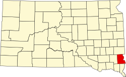
Lincoln County South Dakota Incorporated and Unincorporated areas Tea Highlighted.svg
Location in Lincoln County and the state of South Dakota
Coordinates: 43°27′20″N96°49′26″W / 43.45556°N 96.82389°W / 43.45556; -96.82389
CountryUnited States
State South Dakota
County Lincoln
Founded1894 [1]
Government
  Type Mayor-council government [2]
   Mayor Casey Voelker
   Council Members Ward I: Lynn DeYoung & Joe Weis
Ward II: Aaron Otten & Jim Erck
Ward III: Terry Woessner & Ruby Zuraff
   City Administrator Justin Weiland
  Finance OfficerDawn Murphy
  Planning & Zoning AdministratorKevin Nissen
Area
[3]
  Total3.787 sq mi (9.807 km2)
  Land3.787 sq mi (9.807 km2)
  Water0.000 sq mi (0.000 km2)
Elevation
[4]
1,490 ft (454 m)
Population
 (2020) [5]
  Total5,598
  Estimate 
(2023) [6]
7,381
  Density1,827/sq mi (705.4/km2)
Time zone UTC–6 (Central (CST))
  Summer (DST) UTC–5 (CDT)
ZIP Code
57064
Area code 605
FIPS code 46-63100
GNIS feature ID1267599 [4]
Sales tax 6.2% [7]
Website teasd.com

Tea is a city in Lincoln County, South Dakota, United States and is a suburb of Sioux Falls. The population was 5,598 at the 2020 census, [5] and was estimated to be 7,381 in 2023. [6]

Contents

Tea was laid out in 1894. [8] The name "Tea" was selected on account of its brevity. [9]

Geography

According to the United States Census Bureau, the city has a total area of 3.787 square miles (9.81 km2), all land. [3]

Demographics

Historical population
CensusPop.Note
1910 134
1920 16523.1%
1930 148−10.3%
1940 16511.5%
1950 151−8.5%
1960 18824.5%
1970 30260.6%
1980 729141.4%
1990 7867.8%
2000 1,742121.6%
2010 3,806118.5%
2020 5,59847.1%
2023 (est.)7,381 [6] 31.9%
U.S. Decennial Census [10]
2020 Census [5]

2020 census

As of the 2020 census, there were 5,598 people, 1,897 households, and 1,440 families living in the city. The population density was 1,647.0 inhabitants per square mile (635.9/km2). [11] There were 1,970 housing units. The racial makeup was 91.7% White, 1.2% African American, 0.9% Native American, 0.4% Asian, 0.0% Native Hawaiian, and 5.2% from two or more races. Hispanic or Latino of any race were 2.3% of the population. [12]

2010 census

As of the 2010 census, there were 3,806 people, 1,254 households, and 1,009 families living in the city. The population density was 2,250.2 inhabitants per square mile (868.8/km2). There were 1,354 housing units at an average density of 801.2 per square mile (309.3/km2). The racial makeup of the city was 96.9% White, 0.7% African American, 0.1% Native American, 0.1% Asian, 0.3% from other races, and 1.9% from two or more races. Hispanic or Latino of any race were 1.3% of the population.

There were 1,254 households, of which 59.1% had children under the age of 18 living with them, 63.2% were married couples living together, 12.6% had a female householder with no husband present, 4.7% had a male householder with no wife present, and 19.5% were non-families. 14.0% of all households were made up of individuals, and 2.2% had someone living alone who was 65 years of age or older. The average household size was 3.04 and the average family size was 3.35.

The median age in the city was 27.7 years. 37.5% of residents were under the age of 18; 7.6% were between the ages of 18 and 24; 38.3% were from 25 to 44; 13.9% were from 45 to 64; and 3% were 65 years of age or older. The gender makeup of the city was 50.6% male and 49.4% female.

2000 census

As of the 2000 census, there were 1,742 people, 590 households, and 489 families living in the city. The population density was 2,877.8 inhabitants per square mile (1,111.1/km2). There were 600 housing units at an average density of 991.2 per square mile (382.7/km2). The racial makeup of the city was 96.67% White, 0.40% African American, 0.34% Native American, 0.34% Asian, 0.06% Pacific Islander, 0.40% from other races, and 1.78% from two or more races. Hispanic or Latino of any race were 0.86% of the population.

There were 590 households, out of which 55.6% had children under the age of 18 living with them, 67.3% were married couples living together, 12.7% had a female householder with no husband present, and 17.1% were non-families. 13.1% of all households were made up of individuals, and 2.2% had someone living alone who was 65 years of age or older. The average household size was 2.95 and the average family size was 3.23.

In the city, the population was spread out, with 36.2% under the age of 18, 7.3% from 18 to 24, 40.8% from 25 to 44, 12.5% from 45 to 64, and 3.2% who were 65 years of age or older. The median age was 28 years. For every 100 females, there were 98.4 males. For every 100 females age 18 and over, there were 94.9 males.

As of 2000 the median income for a household in the city was $50,671, and the median income for a family was $52,297. Males had a median income of $32,734 versus $23,860 for females. The per capita income for the city was $17,719. About 2.1% of families and 3.1% of the population were below the poverty line, including 3.8% of those under age 18 and 5.8% of those age 65 or over.

Education

Tea Public Schools are part of the Tea Area School District. The Tea Area School District has three elementary schools, one middle school, and one high school. Students attend Tea Area High School. [13]

Parks

Tea contains three recreational areas: Tea Athletic Complex, Howling Ridge Park, and Prairie Trails Park. [14]

Related Research Articles

<span class="mw-page-title-main">Warwick, North Dakota</span> City in North Dakota, United States

Warwick is a city in Benson County, North Dakota, United States. The population was 55 at the 2020 census. Warwick was founded in 1907.

<span class="mw-page-title-main">Ayr, North Dakota</span> City in North Dakota, United States

Ayr is a city in Cass County, North Dakota, United States. The population was 11 at the 2020 census. Ayr was founded in 1883.

<span class="mw-page-title-main">Page, North Dakota</span> City in North Dakota, United States

Page is a city in Cass County, North Dakota, United States. The population was 190 at the 2020 census. Page was founded in 1882.

<span class="mw-page-title-main">Wales, North Dakota</span> City in North Dakota, United States

Wales is a city in Cavalier County, North Dakota, United States. The population was 10 at the 2020 census. Wales was founded in 1897. Gavilon is Wales' largest employer.

<span class="mw-page-title-main">New Rockford, North Dakota</span> City in North Dakota, United States

New Rockford is a city in Eddy County, North Dakota, United States. It is the county seat of Eddy County. The population was 1,361 at the 2020 census. New Rockford was founded in 1883.

<span class="mw-page-title-main">Hankinson, North Dakota</span> City in North Dakota, United States

Hankinson is a city in Richland County, North Dakota, United States. The population was 921 at the 2020 census. Hankinson was founded in 1886. It is part of the Wahpeton, ND–MN Micropolitan Statistical Area.

<span class="mw-page-title-main">Buxton, North Dakota</span> City in North Dakota, United States

Buxton is a city in Traill County, North Dakota, United States. The population was 348 at the 2020 census. Buxton was founded in 1880.

<span class="mw-page-title-main">Alamo, North Dakota</span> City in North Dakota, United States

Alamo is a city in Williams County, North Dakota, United States. The population was 53 at the 2020 census. Alamo was founded in 1916.

<span class="mw-page-title-main">Chamberlain, South Dakota</span> City in South Dakota, United States

Chamberlain is a city in Brule County, South Dakota, United States. It is located on the east bank of the Missouri River, at the dammed section of the Lake Francis Case, close to where it is crossed by Interstate 90.

<span class="mw-page-title-main">Wagner, South Dakota</span> City in South Dakota, United States

Wagner is a city in Charles Mix County, South Dakota, United States. The population was 1,490 at the 2020 census. The city is served by Wagner Municipal Airport as well as YST Transit buses.

<span class="mw-page-title-main">Lennox, South Dakota</span> City in South Dakota, United States

Lennox is a city in Lincoln County, South Dakota, United States, located 20 miles (32 km) southwest of Sioux Falls. The population was 2,423 at the 2020 census.

<span class="mw-page-title-main">Britton, South Dakota</span> City in South Dakota, United States

Britton is a city in and the county seat of Marshall County, South Dakota, United States. The population was 1,215 at the 2020 census.

<span class="mw-page-title-main">Dell Rapids, South Dakota</span> City in South Dakota, United States

Dell Rapids is a city in Minnehaha County, South Dakota, United States. The population was 3,996 at the 2020 census. It is known as "The Little City with the Big Attractions."

<span class="mw-page-title-main">Garretson, South Dakota</span> City in South Dakota, United States

Garretson is a city in Minnehaha County, South Dakota, United States. The city had a population of 1,228 at the 2020 census.

<span class="mw-page-title-main">Wilmot, South Dakota</span> City in South Dakota, United States

Wilmot is a city in Roberts County, South Dakota, United States. The population was 432 at the 2020 census.

<span class="mw-page-title-main">Elk Point, South Dakota</span> City in South Dakota, United States

Elk Point is a city in and the county seat of Union County, South Dakota, United States. The population was 2,149 as of the 2020 census.

<span class="mw-page-title-main">Tower City, North Dakota</span> City in North Dakota, United States

Tower City is a city in Barnes and Cass counties in the State of North Dakota. The population was 268 at the 2020 census.

<span class="mw-page-title-main">Iroquois, South Dakota</span> City in South Dakota, United States

Iroquois is a city on the border of Beadle and Kingsbury counties in South Dakota, United States. The population was 292 at the 2020 census. The school building is located in Kingsbury County, while the school parking lot is located in Beadle County. Highway 14 runs directly through Iroquois.

<span class="mw-page-title-main">Eagle Butte, South Dakota</span> City in South Dakota, United States

Eagle Butte is a city in Dewey and Ziebach counties in South Dakota, United States. The population was 1,258 at the 2020 census. It is adjacent to the North Eagle Butte CDP.

<span class="mw-page-title-main">Box Elder, South Dakota</span> City in South Dakota, United States

Box Elder is a city in Pennington and Meade counties in the State of South Dakota. The population was 11,746 at the 2020 census, making it the 10th most populous city in South Dakota. Ellsworth Air Force Base lies on the northeast side of the city.

References

  1. "SD Towns" (PDF). South Dakota State Historical Society . Retrieved February 16, 2010.
  2. "City Council & Staff". City of Tea, South Dakota. Retrieved April 13, 2024.
  3. 1 2 "2023 U.S. Gazetteer Files". United States Census Bureau. Retrieved April 13, 2024.
  4. 1 2 U.S. Geological Survey Geographic Names Information System: Tea, South Dakota
  5. 1 2 3 "Explore Census Data". United States Census Bureau . Retrieved April 13, 2024.
  6. 1 2 3 "City and Town Population Totals: 2020–2023". United States Census Bureau. April 13, 2024. Retrieved April 13, 2024.
  7. "Tea (SD) sales tax rate" . Retrieved April 13, 2024.
  8. Federal Writers' Project (1940). South Dakota place-names, v.1-3. American guide series. University of South Dakota. p. 63.
  9. Moyer, Armond; Moyer, Winifred (1958). The origins of unusual place-names. Keystone Pub. Associates. p. 129.
  10. "Census of Population and Housing". United States Census Bureau. Retrieved June 4, 2015.
  11. "US Census Bureau, Table P16: Household Type". United States Census Bureau. Retrieved April 13, 2024.
  12. "How many people live in Tea city, South Dakota". USA Today. Retrieved April 13, 2024.
  13. "Tea Area School District". Tea Area School District. Retrieved August 5, 2012.
  14. "Tea Parks". teasd.com. Retrieved April 19, 2018.