Timeline of South Dakota

Last updated

This timeline of South Dakota is a list of events in the history of South Dakota by year.

Contents

First people

Arikara man, wearing a bearskin, 1908 Bear's Belly by Edward Curtis, 1908.jpg
Arikara man, wearing a bearskin, 1908

16th century

17th century

1670-1707

1683

1699-1764

18th century

1700

1743

1745

1750

1762

1764-1803

1775

1780

1785

1790

1792

1796

1797

19th century

1800

1803

1804

1805

1806

1807

Manuel Lisa Manuel Lisa.JPG
Manuel Lisa

1808

1809

1810

1811

1812

1813

1815

1816

1817

1818

1822

1823

1825

1828

1831

1832

1837

1838

1839

1840

1842

1845

1847

1849

1851

1855

1856

1857

1858

1859

1860

1861

1862

1863

1864

1865

1866

1868

1869

1870

1872

1873

1874

1875

Miners in the Black Hills Custerblackhills.jpg
Miners in the Black Hills

1876

1877

1878

1879

1880

1881

1882

1883

1884

1885

1887

1889

1890

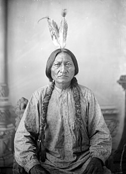
Sitting Bull, a Hunkpapa Lakota leader, was one of the principal Sioux leaders. Sitting Bull by D F Barry ca 1883 Dakota Territory.jpg
Sitting Bull, a Hunkpapa Lakota leader, was one of the principal Sioux leaders.
View of canyon at Wounded Knee, dead horses and Lakota bodies are visible. Woundedkneescenedeadandhorses.jpg
View of canyon at Wounded Knee, dead horses and Lakota bodies are visible.

1891

1895

1896

1897

1898

1899

20th century

1901

1903

1904

1905

1924

1927

Construction of the Mount Rushmore monument Mount Rushmore2.jpg
Construction of the Mount Rushmore monument

1933

1934

Dust Storms, "One of South Dakota's Black Blizzards, 1934" Dust Storms, "One of South Dakota's Black Blizzards, 1934" - NARA - 195304.tif
Dust Storms, "One of South Dakota's Black Blizzards, 1934"

1935

1936

Dust Bowl - Dallas, South Dakota 1936 Dust Bowl - Dallas, South Dakota 1936.jpg
Dust Bowl - Dallas, South Dakota 1936

1938

1946

1948

Oahe Dam from the International Space Station Pierre South Dakota.jpg
Oahe Dam from the International Space Station

1952

Late 1950s

1959

1961

1972

Cars jumbled together by the flood. Rapid City SD wea00703.jpg
Cars jumbled together by the flood.

1973

1978

1980

1981

1988

21st century

2002

2004

2012

2013

2019

See also

Related Research Articles

<span class="mw-page-title-main">Lakota people</span> Indigenous people of the Great Plains

The Lakota are a Native American people. Also known as the Teton Sioux, they are one of the three prominent subcultures of the Sioux people, with the Eastern Dakota (Santee) and Western Dakota (Wičhíyena). Their current lands are in North and South Dakota. They speak Lakȟótiyapi—the Lakota language, the westernmost of three closely related languages that belong to the Siouan language family.

<span class="mw-page-title-main">Sioux</span> Native American and First Nations ethnic groups

The Sioux or Oceti Sakowin are groups of Native American tribes and First Nations peoples from the Great Plains of North America. The Sioux have two major linguistic divisions: the Dakota and Lakota peoples. Collectively, they are the Očhéthi Šakówiŋ, or "Seven Council Fires". The term "Sioux", an exonym from a French transcription ("Nadouessioux") of the Ojibwe term "Nadowessi", can refer to any ethnic group within the Great Sioux Nation or to any of the nation's many language dialects.

<span class="mw-page-title-main">Flandreau, South Dakota</span> City in South Dakota, United States

FlandreauFLAN-droo is a city in and county seat of Moody County, South Dakota, United States. The population was 2,372 at the 2020 census. It was named in honor of Charles Eugene Flandrau, a judge in the territory and state of Minnesota. He is credited with saving the community of New Ulm, Minnesota, from destruction during conflict with the Sioux tribe in 1862.

<span class="mw-page-title-main">Manuel Lisa</span>

Manuel Lisa, also known as Manuel de Lisa, was a Spanish citizen and later, became an American citizen who, while living on the western frontier, became a land owner, merchant, fur trader, United States Indian agent, and explorer. Lisa was among the founders, in St. Louis, of the Missouri Fur Company, an early fur trading company. Manuel Lisa gained respect through his trading among Native American tribes of the upper Missouri River region, such as the Teton Sioux, Omaha and Ponca.

<span class="mw-page-title-main">The Dakotas</span> Region in the United States

The Dakotas is a collective term for the U.S. states of North Dakota and South Dakota. It has been used historically to describe the Dakota Territory, and is still used for the collective heritage, culture, geography, fauna, sociology, economy, and cuisine of the two states.

<span class="mw-page-title-main">Arikara War</span>

The Arikara War was an armed conflict between the United States, their allies from the Sioux tribe and Arikara Native Americans that took place in the summer of 1823, along the Missouri River in present-day South Dakota. It was the first Indian war west of the Missouri fought by the U.S. Army and its only conflict ever with the Arikara. The war came as a response to an Arikara attack on trappers, called "the worst disaster in the history of the Western fur trade".

<span class="mw-page-title-main">Arikara</span> Ethnic group

Arikara, also known as Sahnish, Arikaree, Ree, or Hundi, are a tribe of Native Americans in North Dakota. Today, they are enrolled with the Mandan and the Hidatsa as the federally recognized tribe known as the Mandan, Hidatsa, and Arikara Nation.

The Mdewakanton or Mdewakantonwan are one of the sub-tribes of the Isanti (Santee) Dakota (Sioux). Their historic home is Mille Lacs Lake in central Minnesota. Together with the Wahpekute, they form the so-called Upper Council of the Dakota or Santee Sioux. Today their descendants are members of federally recognized tribes in Minnesota, South Dakota and Nebraska of the United States, and First Nations in Manitoba, Canada.

<span class="mw-page-title-main">Hunkpapa</span> Traditional tribal grouping within the Lakota people

The Hunkpapa are a Native American group, one of the seven council fires of the Lakota tribe. The name Húŋkpapȟa is a Lakota word, meaning "Head of the Circle". By tradition, the Húŋkpapȟa set up their lodges at the entryway to the circle of the Great Council when the Sioux met in convocation. They speak Lakȟóta, one of the three dialects of the Sioux language.

<span class="mw-page-title-main">Great Sioux Reservation</span> Former Indian reservation in the United States

The Great Sioux Reservation initially set aside land west of the Missouri River in South Dakota and Nebraska for the use of the Sioux, who had dominated this territory. The reservation was established in the Fort Laramie Treaty of 1868. It included all of present-day western South Dakota and modern Boyd County, Nebraska. This area was established by the United States as a reservation for the Teton Sioux, also known as the Lakota: the seven western bands of the "Seven Council Fires".

<span class="mw-page-title-main">War Eagle (Dakota Leader)</span>

War Eagle was a Dakota-born tribal chief of the Yankton Sioux Tribe.

<span class="mw-page-title-main">Yankton Indian Reservation</span> Indian reservation in United States, Yankton Sioux

The Yankton Indian Reservation is the homeland of the Yankton Sioux Tribe of the Dakota tribe.

<span class="mw-page-title-main">Dakota people</span> Native American people in the mid northern U.S. and mid southern Canada

The Dakota are a Native American tribe and First Nations band government in North America. They compose two of the three main subcultures of the Sioux people, and are typically divided into the Eastern Dakota and the Western Dakota.

<span class="mw-page-title-main">Théophile Bruguier</span> Canadian fur trader

Theophile Bruguier was a French-Canadian fur trader with the American Fur Company. Bruguier is credited as being the first white settler of what would become Sioux City, Iowa.

<span class="mw-page-title-main">Lower Brule Indian Reservation</span> Reservation in South Dakota, United States

The Lower Brulé Indian Reservation is an Indian reservation that belongs to the Lower Brulé Lakota Tribe. It is located on the west bank of the Missouri River in Lyman and Stanley counties in central South Dakota in the United States. It is adjacent to the Crow Creek Indian Reservation on the east bank of the river. The Kul Wicasa Oyate, the Lower Brulé Sioux, are members of the Sicangu, one of the bands of the Lakota Tribe. Tribal headquarters is in Lower Brule.

Medary is an unincorporated community in Brookings County, South Dakota, United States. Founded in 1857 by the Dakota Land Company, it was one of the first towns in South Dakota. It is not tracked by the U.S. Census Bureau.

<span class="mw-page-title-main">History of South Dakota</span> Aspect of history

The history of South Dakota describes the history of the U.S. state of South Dakota over the course of several millennia, from its first inhabitants to the recent issues facing the state.

<span class="mw-page-title-main">Fort Pierre Chouteau</span> United States historic place

Fort Pierre Chouteau, also just Fort Pierre, was a major trading post and military outpost in the mid-19th century on the west bank of the Missouri River in what is now central South Dakota. Established in 1832 by Pierre Chouteau, Jr. of St. Louis, Missouri, whose family were major fur traders, this facility operated through the 1850s.

<span class="mw-page-title-main">Yankton Sioux Tribe</span> Federally recognized tribe in South Dakota, U.S.

The Yankton Sioux Tribe of South Dakota is a federally recognized tribe of Yankton Western Dakota people, located in South Dakota. Their Dakota name is Ihaƞktoƞwaƞ Dakota Oyate, meaning "People of the End Village" which comes from the period when the tribe lived at the end of Spirit Lake just north of Mille Lacs Lake. The CNWRR records state the name is alternately spelled with an "E" instead of an "I" or "Ehanktowan".

<span class="mw-page-title-main">Yankton Treaty</span>

The Yankton Treaty was a treaty signed in 1858 between the United States Government and the Yankton Sioux Tribe, that ceded most of eastern South Dakota to the U.S. Government. The treaty was signed in April 1858, and ratified by the United States Congress on February 16, 1859. In 1851 the Yankton and Yanktonai tribes were not included in the Traverse des Sioux Treaty. Governor Ramsey used the Nicollet map of the Upper Mississippi River basin from 1840 to draw the boundaries. He saw the Big Sioux River as a geographic feature separating the Sisseton and Yankton and Yanktonai tribes. Chief Waanata 1 of the Yanktonai claimed from Granite Falls to the Missouri river. Chief Struck-by-the-Ree of the Yankton claimed the land into Minnesota to the Jeffers Petroglyphs. The Yankton made their objections known. The Government realized the Yankton claim was so strong that the Yankton treaty was drawn up. As the Government felt it did not have free and clear title to the land for the statehood of Minnesota. Paragraph 1 of the 1858 Yankton treaty addresses these claims immediately. However, Struck-by-the-Ree would not sign without a provision for the Pipestone quarry. Article 8 was added giving the Yankton a one mile square Reservation at Pipestone. Struck-by-the-Ree signed and one month later Minnesota gained statehood. The Yanktonai being more remote failed to have their objections considered. The 1858 treaty immediately opened this territory up for settlement, resulting in the establishment of an unofficial local government not recognized by Washington. The treaty also created the primary 430,000 acre Yankton Sioux Reservation, now located in Charles Mix County in South Dakota.

References

This article incorporates public domain text: Robinson, Doane (1905). A Brief History of South Dakota. American Book Company. pp.  215–221.

  1. 1 2 3 "South Dakota State Historical Society". history.sd.gov. Retrieved 2018-06-25.
  2. 1 2 3 4 5 6 Hufstetler, Mark; Bedeau, Michael (1998). South Dakota’s Railroads: An Historic Context (PDF). South Dakota State Historic Preservation Office. Retrieved April 20, 2018.
  3. "Fort Randall". National Park Service. Retrieved April 20, 2018.
  4. Robinson, Doane (1902). South Dakota Historical Collections. South Dakota State Historical Society. p. 116. Retrieved May 20, 2015.
  5. Robinson, Doane (1904). History of South Dakota. B. F. Bowen. p.  250 . Retrieved 20 May 2015.
  6. 1 2 Springfield, South Dakota, Centennial. Springfield Times. 1970.
  7. South Dakota Department of Highways (1958). Annual Report to the Governor. p. 6. Retrieved 20 May 2015.
  8. Teller, Janet. "USGS Fact Sheet 037-02: The 1972 Black Hills-Rapid City Flood Revisited". pubs.usgs.gov. Retrieved 2015-05-20.
  9. "South Dakota Department of Transportation - Current Rail System". South Dakota Department of Transportation . Retrieved 2018-04-30.
  10. Whitney, Stu (April 7, 2015). "What really happened to land Citibank". Argus Leader . Retrieved May 21, 2015.