Big Bend Dam

Last updated
Big Bend Dam
USACE Fort Thompson Big Bend Dam.jpg
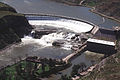
Big Bend Dam on the Missouri River, with Lake Sharpe in the background.
USA South Dakota relief location map.svg
Red pog.svg
Location of Big Bend Dam in the State of South Dakota.
Official nameBig Dam
Country United States
Location Buffalo/Lyman Counties, South Dakota.
Coordinates 44°02′58″N99°26′55″W / 44.049473°N 99.448586°W / 44.049473; -99.448586 Coordinates: 44°02′58″N99°26′55″W / 44.049473°N 99.448586°W / 44.049473; -99.448586
StatusOperational
Construction began1959;62 years ago (1959)
Opening date1963;58 years ago (1963)
Construction cost$107 million
Owner(s) United States Army Corps of Engineers logo.svg U.S. Army Corps of Engineers, Omaha District
Dam and spillways
Type of dam Embankment, Rolled-earth shale fill & chalk fill
Impounds Missouri River
Height95 ft (29 m)
Length10,570 ft (3,222 m) (including spillway)
Elevation at crest1,423 feet msl
Width (base)1,200 ft (366 m)
Dam volume17,000,000 cu yd (12,997,433 m3)
Spillways 8 - 40-foot x 38-foot tainter gates
Spillway typecontrolled (gated)
Spillway capacity270,000 cfs at 1,423 feet msl
Reservoir
Creates Lake Sharpe
Total capacity1,798,000 acre⋅ft (2.217800344×10⁹ m3)
Catchment area 5,840 sq mi (15,126 km2)
Surface area56,884 acres (23,020 ha)
Maximum length80 mi (129 km)
Maximum water depth78 ft (24 m)
Normal elevation1,420-1,423 feet msl
Power Station
Operator(s) U.S. Army Corps of Engineers
Commission dateOctober 1964
Turbines 8 Fixed blade, 81.8 rpm
Installed capacity 494,320 Kw
Annual generation 969 million kilowatt hours
Website
U.S. Army Corps of Engineers - Big Bend Dam / Lake Sharpe
Lake Sharpe with visible Big Bend Dam from space, August 1989. View is to the east-southeast. Lake Sharpe Big Bend.jpg
Lake Sharpe with visible Big Bend Dam from space, August 1989. View is to the east-southeast.

Big Bend Dam is a major embankment rolled-earth dam on the Missouri River in Central South Dakota, United States, creating Lake Sharpe. The dam was constructed by the U.S. Army Corps of Engineers as part of the Pick-Sloan Plan for Missouri watershed development authorized by the Flood Control Act of 1944. Construction began in 1959 and the embankment was completed in July 1963. Power generation began at the facility in 1964 and the entire complex was completed in 1966 at a total cost of $107 million. The hydroelectric plant generates 493,300 kilowatts of electricity at maximum capacity, with an annual production of 969 million kilowatt hours, [1] and meets peak-hour demand for power within the Missouri River Basin.

Contents

Located near Fort Thompson, South Dakota, just south of the Big Bend of the Missouri River, a large meander, Big Bend Dam creates Lake Sharpe, named after South Dakota Governor Merrill Q. Sharpe. The lake extends for 80 miles (130 km) up the course of the Missouri River passing through Pierre, the State Capitol, to Oahe Dam, another major power-generating and flood control dam. Lake Sharpe covers a total of 56,884 acres (23,020 ha) and drains an area just under 250,000 square miles (650,000 km2).

South Dakota Highway 47 crosses over the dam, connecting Lyman and Buffalo Counties. Big Bend Dam is located approximately 17 miles (27 km) north of I-90, and approximately 60 miles (97 km) southeast of Pierre.

The next dam upstream is Oahe Dam, near Pierre, and the next dam downstream is Fort Randall Dam, near Pickstown.

Native American tribes

The construction of the dam resulted in the dislocation of people on the Crow Creek and Lower Brule Reservations. The flooding of the land for the reservoir also resulted in the loss of limited plant life resources used by them for food and medicine.

A monument at Big Bend Dam dedicated in 2002, the Spirit of the Circle Monument, honors the more than 1,300 people who died over a three-year period in the 1860s at the Crow Creek Reservation near the present site of the dam. [2]

2011 Missouri River flood

For the first time in the dam's history, the US Army Corps of Engineers opened the dam's spillway gates on the morning of June 3, 2011. In response to the 2011 Missouri River Floods, the dam was releasing 150,000 cubic feet per second (4,200 m3/s), which greatly exceeded its previous record release of 74,000 cu ft/s (2,100 m3/s) set in 1997. [3]

See also

Related Research Articles

Missouri River Major river in the central United States

The Missouri River is the longest river in North America. Rising in the Rocky Mountains of western Montana, the Missouri flows east and south for 2,341 miles (3,767 km) before entering the Mississippi River north of St. Louis, Missouri. The river drains a sparsely populated, semi-arid watershed of more than 500,000 square miles (1,300,000 km2), which includes parts of ten U.S. states and two Canadian provinces. Although nominally considered a tributary of the Mississippi, the Missouri River above the confluence is much longer and carries a comparable volume of water. When combined with the lower Mississippi River, it forms the world's fourth longest river system.

Lake Sakakawea Man-made reservoir in North Dakota, United States

Lake Sakakawea is a large reservoir in the north central United States, impounded in 1953 by Garrison Dam, a U.S. Army Corps of Engineers dam located in the Missouri River basin in central North Dakota. Named for the Shoshone-Hidatsa woman Sakakawea, it is the largest man-made lake located entirely within the State of North Dakota, the second largest in the United States by area after Lake Oahe, and the third largest in the United States by volume, after Lake Mead and Lake Powell.

Garrison Dam Dam in McLean/Mercer Counties, North Dakota

Garrison Dam is an earth-fill embankment dam on the Missouri River in central North Dakota, U.S.. Constructed by the U.S. Army Corps of Engineers from 1947 to 1953, at over 2 miles (3.2 km) in length, the dam is the fifth-largest earthen dam in the world. The reservoir impounded by the dam is Lake Sakakawea, which extends to Williston and the confluence with the Yellowstone River, near the Montana border.

Fort Randall Dam Dam in Gregory County and Charles Mix County, South Dakota.

Fort Randall Dam is a 2.03 mi (3 km) long earthen dam which spans the Missouri River and impounds Lake Francis Case, the 11th largest reservoir in the U.S. The dam joins Gregory and Charles Mix County, South Dakota a distance of 880 river miles (1,416 km) upstream of St. Louis, Missouri, where the river joins the Mississippi River. The dam and Hydroelectric power plant were constructed by and are currently operated by the U.S. Army Corps of Engineers.

Pick–Sloan Missouri Basin Program

The Pick–Sloan Missouri Basin Program, formerly called the Missouri River Basin Project, was initially authorized by the Flood Control Act of 1944, which approved the plan for the conservation, control, and use of water resources in the Missouri River Basin.

Fort Peck Dam Dam in Montana, US

The Fort Peck Dam is the highest of six major dams along the Missouri River, located in northeast Montana in the United States, near Glasgow, and adjacent to the community of Fort Peck. At 21,026 feet (6,409 m) in length and over 250 feet (76 m) in height, it is the largest hydraulically filled dam in the United States, and creates Fort Peck Lake, the fifth largest artificial lake in the U.S., more than 130 miles (210 km) long, 200 feet (61 m) deep, and it has a 1,520-mile (2,450 km) shoreline which is longer than the state of California's coastline. It lies within the Charles M. Russell National Wildlife Refuge. The dam and the 134-mile-long (216 km) lake are owned and operated by the U.S. Army Corps of Engineers and exist for the purposes of hydroelectric power generation, flood control, and water quality management.

Fort Peck Lake

Fort Peck Lake, or Lake Fort Peck, is a major reservoir in Montana, formed by the Fort Peck Dam on the Missouri River. The lake lies in the eastern prairie region of Montana approximately 140 miles (230 km) east of Great Falls and 120 miles (190 km) north of Billings, reaching into portions of six counties.

Lake Sharpe

Lake Sharpe is a large reservoir impounded by Big Bend Dam on the Missouri River in central South Dakota, United States. The lake has an area of 56,884 acres (230.20 km2) and a maximum depth of 78 ft (24 m). Lake Sharpe is approximately 80 mi (130 km) long, with a shoreline of 200 mi (320 km). Lake Sharpe is the 54th largest reservoir in the United States. The lake starts near Ft. Thompson and stretches upstream to Oahe Dam, near Pierre. The lake is located within the following counties: Buffalo, Lyman, Hyde, Hughes, and Stanley. The Big Bend of the Missouri is about 7 miles (11 km) north of the dam.

Oahe Dam Dam in Hughes/Stanley counties, South Dakota

The Oahe Dam is a large earthen dam on the Missouri River, just north of Pierre, South Dakota, United States. The dam creates Lake Oahe, the fourth-largest man-made reservoir in the United States. The reservoir stretches 231 miles (372 km) up the course of the Missouri to Bismarck, North Dakota. The dam's power plant provides electricity for much of the north-central United States. It is named for the Oahe Indian Mission established among the Lakota Sioux in 1874.

Lake Oahe

Lake Oahe is a large reservoir behind Oahe Dam on the Missouri River; it begins in central South Dakota and continues north into North Dakota in the United States. The lake has an area of 370,000 acres (1,500 km2) and a maximum depth of 205 ft (62 m). By volume, it is the fourth-largest reservoir in the US. Lake Oahe has a length of approximately 231 mi (372 km) and has a shoreline of 2,250 mi (3,620 km). 51 recreation areas are located along Lake Oahe, and 1.5 million people visit the reservoir every year. The lake is named for the 1874 Oahe Indian Mission.

Crow Creek Indian Reservation Reservation in South Dakota, United States

The Crow Creek Indian Reservation is located in parts of Buffalo, Hughes, and Hyde counties on the east bank of the Missouri River in central South Dakota in the United States. It has a land area of 421.658 square miles (1,092.09 km2) and a 2000 census population of 2,225 persons. The major town and capital of the Crow Creek Sioux Tribe is Fort Thompson.

Gavins Point Dam Dam in Cedar County, Nebraska and Yankton County, South Dakota.

Gavins Point Dam is a 1.9 mi (3 km) long embankment rolled-earth and chalk-fill dam which spans the Missouri River and impounds Lewis and Clark Lake. The dam joins Cedar County, Nebraska with Yankton County, South Dakota a distance of 811.1 river miles (1,305 km) upstream of St. Louis, Missouri, where the river joins the Mississippi River. The dam and hydroelectric power plant were constructed as the Gavins Point Project from 1952 to 1957 by the United States Army Corps of Engineers as part of the Pick-Sloan Plan. The dam is located approximately 4 miles (6.4 km) west or upstream of Yankton, South Dakota.

Lake Francis Case

Lake Francis Case is a large reservoir impounded by Fort Randall Dam on the Missouri River in south-central South Dakota, United States. The lake has an area of 102,000 acres (410 km2) and a maximum depth of 140 ft (43 m). Lake Francis Case has a length of approximately 107 mi (172 km) and has a shoreline of 540 mi (870 km). The lake is the eleventh-largest reservoir in the United States and is located within the counties of: Charles Mix, Gregory, Lyman, Brule, and Buffalo. The lake stretches from Pickstown, South Dakota upstream to Big Bend Dam.

Lower Brule Indian Reservation Reservation in South Dakota, United States

The Lower Brulé Indian Reservation is an Indian reservation that belongs to the Lower Brulé Lakota Tribe. It is located on the west bank of the Missouri River in Lyman and Stanley counties in central South Dakota in the United States. It is adjacent to the Crow Creek Indian Reservation on the east bank of the river. The Kul Wicasa Oyate (lower…men…nation), the Lower Brulé Sioux, are members of the Sicangu, one of the bands of the Lakota Tribe. Tribal headquarters is in Lower Brule.

Bowman-Haley Dam Dam in Bowman County, North Dakota

Bowman-Haley Dam is an embankment dam located in Bowman County, North Dakota, in the southwestern part of the state. The dam is just over 2 miles north of the South Dakota border.

This timeline of South Dakota is a list of events in the history of South Dakota by year.

Oahe Downstream Recreation Area

Oahe Downstream Recreation Area is a state recreation area in Stanley County, South Dakota in the United States. The recreation area is named for being immediately downstream of the Oahe Dam and Lake Oahe, a U.S. Army Corps of Engineers dam and reservoir. The recreation area is located along the Missouri River and is popular for camping, fishing and other water-based recreation. The area is located about 7 miles upstream of Pierre - the state capitol. The recreation area was constructed by the U.S. Army Corps of Engineers following construction of Oahe Dam, and legislation passed by Congress transferred ownership of the recreation area to the State of South Dakota in 2002.

The Big Bend is a large meander of the Missouri River in South Dakota, now impounded by the Big Bend Dam, 7 miles (11 km) to its south, as part of Lake Sharpe.

References

  1. "Summary of Engineering Data – Missouri River Main Stem System" (PDF). Missouri River Division. U.S. Army Corps of Engineers. August 2010. Archived from the original (PDF) on 2012-02-07. Retrieved 2012-08-17.
  2. Melmer, David (June 19, 2002). "Dakota sacrifice honored". Indian Country Today. Retrieved 2008-09-27.
  3. "Missouri River Mainstem Reservoir Bulletin" (pdf). Army Corps of Engineers. Retrieved 18 June 2011.[ permanent dead link ]