
Caesar Creek State Park is a public recreation area located in southwestern Ohio, five miles (8 km) east of Waynesville, in Warren, Clinton, and Greene counties. The park is leased by the State from the U.S. Army Corps of Engineers, who in the 1970s erected a dam on Caesar Creek to impound a 2,830-acre (1,150 ha) lake. The total park area, including the lake, is 7,530-acre (3,050 ha).

Cave Run Lake, located south of Morehead, Kentucky, USA along Kentucky Route 801, is an 8,270-acre (33 km2) reservoir built by the U.S. Army Corps of Engineers. The 148 ft (45 m), half-mile dam construction began in 1965 and was completed in 1973. Cave Run Lake is in the northern part of the Daniel Boone National Forest. Cave Run Lake provides flood protection to the lower Licking River valley, supplies water to the area's communities, improves the Licking River's water flow conditions, and offers a habitat for various species of fish and wildlife. It is in Rowan, Morgan, Menifee, and Bath counties.

Lake Whitney is a flood control reservoir on the main stem of the Brazos River in Texas. It is located on River Mile Marker 442 and controls drainage for 17,656 square miles (45,730 km2) of Texas and parts of New Mexico. The reservoir encompasses a surface area of more than 23,500 acres and 225 miles (362 km) of shoreline. The area consists of rolling, tallgrass prairies; cedar trees; hardwood timber; and 100 ft (30 m) bluffs and rock points. Lake Whitney is also part of the Texas Lakes Trail Region of North Texas.

Hansen Dam is a flood control dam in the northeastern San Fernando Valley, in the Lake View Terrace neighborhood of Los Angeles, California. The dam was built by the U.S. Army Corps of Engineers, Los Angeles District in 1940. Hansen Dam was named after horse ranchers Homer and Marie Hansen, who established a ranch in the 19th century.

Foster Reservoir is a reservoir created by Foster Dam on the South Santiam River in the city of Foster, Oregon, United States. The reservoir is approximately 5.6 km (3.5 mi) long and covers approximately 494 ha when full. Primary use of the reservoir is recreation in the summer and flood control in the winter and spring.

Tuttle Creek Lake is a reservoir on the Big Blue River 5 miles (8 km) north of Manhattan, in the Flint Hills region of northeast Kansas. It was built and is operated by the Army Corps of Engineers for the primary purpose of flood control. Secondary functions of the project include release of water stores to maintain barge traffic on the Mississippi River during seasons of drought, maintenance of a multi-use conservation pool for fish and wildlife enhancement and recreation, and release of sufficient water in droughts to maintain water quality for downstream communities.

Clinton Lake is a reservoir on the southwestern edge of Lawrence, Kansas. The lake was created by the construction of the Clinton Dam, and the 35 square miles (91 km²) of land and water is maintained by the U.S. Army Corps of Engineers.

Wilson Lake is a reservoir in the U.S. state of Kansas, on the border of Russell County and Lincoln County. Built and managed by the U.S. Army Corps of Engineers for flood control, it is also used for wildlife management and recreation. Several parks are located along its shoreline, including Wilson State Park.

Perry Lake is a US Army Corps of Engineers operated reservoir in northeast Kansas. Its primary purposes are flood control, water reserve for nearby areas and regional recreation. The lake is approximately 11,150 acres (45 km²) in size, with over 160 miles (260 km) of shoreline. Perry Lake's full multi-purpose pool elevation is 891.5 feet (271.7 m) above sea level. Perry Lake is located about 40 miles (64 km) west of Kansas City, just northwest of Lawrence, Kansas. Its close proximity to Kansas City, Lawrence, and the state capitol, Topeka, make it a very popular destination, with the nickname "Paradise on the Plains".

Kettle Creek State Park is a 1,793-acre (726 ha) Pennsylvania state park in Leidy Township, Clinton County, Pennsylvania in the United States. The park is in a valley and is surrounded by mountains and wilderness. It features the Alvin R. Bush Dam built in 1961 by the U.S. Army Corps of Engineers as a flood control measure in the West Branch Susquehanna River basin. Many of the recreational facilities at the park were built during the Great Depression by the young men of the Civilian Conservation Corps. Kettle Creek State Park is seven miles (10 km) north of Westport and Pennsylvania Route 120. It is largely surrounded by Sproul State Forest.

Chatfield Dam and Reservoir is a dam and artificial lake located on the South Platte River, south of Littleton, Colorado. The dam and reservoir were built by the United States Army Corps of Engineers as a response to the disastrous flood of 1965. In addition to its primary purpose of flood control, it serves as one of many water supply reservoirs for the city of Denver, Colorado. In 1966, the U.S. Atomic Energy Commission projected a total federal cost of $74 million. Construction of the project was begun in 1967 and the dam was completed in 1975.

El Dorado Lake is a reservoir on the Walnut River 0.5 miles (0.80 km) northeast of El Dorado in the Flint Hills region of Kansas. Built and managed by the U.S. Army Corps of Engineers, it is used for flood control, recreation, and water supply. El Dorado State Park is located on its shore.
Grapevine Lake is an American reservoir located in the North Texas region, approximately 20 mi (32 km) northwest of Dallas and northeast of Fort Worth. It was impounded in 1952 by the US Army Corps of Engineers when they dammed Denton Creek, a tributary of Trinity River.

Lost Creek Lake is a reservoir located on the Rogue River in Jackson County, Oregon, United States. The lake is impounded by William L. Jess Dam which was constructed by the U.S. Army Corps of Engineers in 1977 for flood control and fisheries enhancement. The lake and dam were the first completed elements of the multi-purpose Rogue River Basin Project, consisting of Lost Creek Lake, Applegate Lake and the Elk Creek project. The lake is located approximately 27 miles (43 km) northeast of Medford.

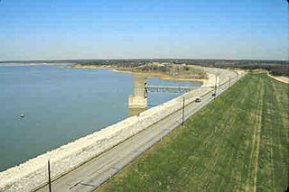
The Harlan County Reservoir includes a dam and a reservoir of 13,250 acres (54 km2) located in Harlan County in south-central Nebraska. Its southernmost part extends into northern Phillips County, Kansas. The reservoir is formed by a dam constructed by the U.S. Army Corps of Engineers on the Republican River, which starts in Colorado and ends in Kansas.

John Redmond Reservoir is a reservoir on the Neosho River in eastern Kansas. Built and managed by the U.S. Army Corps of Engineers, it is used for flood control, recreation, water supply, and wildlife management. It borders the Flint Hills National Wildlife Refuge to the northwest.

Kanopolis Lake is a reservoir in Ellsworth County in the Smoky Hills of central Kansas, about 31 miles southwest of Salina and a few miles southeast of the town of Kanopolis. The lake is formed by Kanopolis Dam. Completed in 1948 as a flood control and water conservation project of the United States Army Corps of Engineers, the dam impounds the Smoky Hill River.

Cherry Creek Dam is a dam in Arapahoe County, Colorado southeast of Denver.
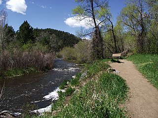
Bear Creek is a tributary of the South Platte River in central Colorado in the United States. It begins as a small creek up in the Mount Blue Sky Wilderness in Summit Lake and makes it's way through Evergreen, CO, Kittredge, CO, Idledale, CO and Morrison, CO before entering into Bear Ponds. The stream flows to a confluence with the South Platte River in Sheridan, Colorado, just south of Denver, and then into the South Platte River near Englewood. As it moves downstream, Kerr Gulch, Cold Spring Gulch and Saw Mill Gulch all add to its flow making it a sustainable river to fish from spring to fall, with close access to the Denver area.
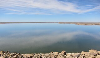
John Martin Reservoir is a reservoir on the Arkansas River in southeastern Colorado. Built and managed by the U.S. Army Corps of Engineers, it is used for flood control, irrigation, and recreation. John Martin Reservoir State Park lies on its shore.
